China Maritime Report No. 3: China's Distant-Ocean Survey Activities: Implications for U.S. National Security - Andrew S. Erickson
←
→
Page content transcription
If your browser does not render page correctly, please read the page content below
U.S. Naval War College
U.S. Naval War College Digital Commons
CMSI China Maritime Reports                                                                                                  Reports & Studies

11-2018

China Maritime Report No. 3: China’s Distant-
Ocean Survey Activities: Implications for U.S.
National Security
Ryan D. Martinson

Peter A. Dutton

Follow this and additional works at: https://digital-commons.usnwc.edu/cmsi-maritime-reports

Recommended Citation
Martinson, Ryan D. and Dutton, Peter A., "China Maritime Report No. 3: China’s Distant-Ocean Survey Activities: Implications for
U.S. National Security" (2018). CMSI China Maritime Reports. 3.
https://digital-commons.usnwc.edu/cmsi-maritime-reports/3

This Book is brought to you for free and open access by the Reports & Studies at U.S. Naval War College Digital Commons. It has been accepted for
inclusion in CMSI China Maritime Reports by an authorized administrator of U.S. Naval War College Digital Commons. For more information, please
contact repository.inquiries@usnwc.edu.
CHINA MARITIME STUDIES INSTITUTE
                                CENTER FOR NAVAL WARFARE STUDIES
                                     U.S. NAVAL WAR COLLEGE
                                      686 CUSHING ROAD (3C)
                                   NEWPORT, RHODE ISLAND 02841

         China’s Distant-Ocean Survey Activities:
           Implications for U.S. National Security

                         Ryan D. Martinson and Peter A. Dutton1

                               China Maritime Report No. 3
                                      November 2018
                              China Maritime Studies Institute
                                  U.S. Naval War College
                                  Newport, Rhode Island

Today, the People’s Republic of China (PRC) is investing in marine scientific research on a massive
scale. This investment supports an oceanographic research agenda that is increasingly global in
scope. One key indicator of this trend is the expanding operations of China’s oceanographic research
fleet. On any given day, 5-10 Chinese “scientific research vessels” (科学考查船) may be found
operating beyond Chinese jurisdictional waters, in strategically-important areas of the Indo-Pacific.
Overshadowed by the dramatic growth in China’s naval footprint, their presence largely goes
unnoticed. Yet the activities of these ships and the scientists and engineers they embark have major
implications for U.S. national security.

This report explores some of these implications. It seeks to answer basic questions about the out-of-

area—or “distant-ocean” (远洋)—operations of China’s oceanographic research fleet. Who is

organizing and conducting these operations? Where are they taking place? What do they entail?
What are the national drivers animating investment in these activities?

It comprises five parts. Part one defines the fleet, and the organizations that own and operate it. Part
two examines primary operating areas. Part three describes the range of activities conducted by
Chinese research vessels while operating in distant-ocean areas. Part four sketches the key strategic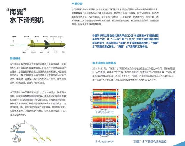
purposes driving state investment in out-of-area oceanography. Part five discusses the implications of
Chinese oceanographic research for U.S. national security.

Fleet Composition

Several different Chinese agencies, research institutes, and universities own and operate
oceanographic research vessels. Until 2018, the State Oceanic Administration owned by far the most
ships, including the large Xiang Yang Hong series of vessels. In March 2018, China’s National
People’s Congress passed legislation to dissolve the State Oceanic Administration, placing its
functions under the new Ministry of Natural Resources (MNR).2 Within the MNR, several institutes
conduct out-of-area research. Chief among them are the First, Second, and Third Institutes of
Oceanography. They own their own vessels and often embark their scientists aboard ships operated
by other groups. MNR oversees the Polar Institute of China, owner of the 20,000-ton Snow Dragon
polar research vessel. Each of the MNR’s regional bureaus—North, East, and South—also own and
operate ships capable of out-of-area research operations.

MNR vessels constitute the bulk of China’s National Marine Research Fleet. The National Fleet was
set up in 2012 in order to improve coordination between ship owners and foster information sharing.
This was an apparent attempt to emulate the University-National Oceanographic Laboratory System
(UNOLS), which coordinates civilian use of oceanographic research vessels in the United States.3 A
Coordination Commission formulates policy guiding use of the National Fleet.4 A government
official heads the Commission. Decisions made by the Commission are implemented by its office,
located within the MNR’s Department of Science and Technology.5

Several other organizations own ships that belong to the National Fleet. Two are major players in
distant-ocean operations: the Chinese Academy of Sciences (CAS) and China Ocean Mineral
Resources R & D Association (COMRA). CAS owns a handful of research vessels, including the
Shiyan 3, which in early 2018 surveyed Pakistan’s exclusive economic zone (EEZ), and the Kexue, a
frequent visitor to the Philippine Sea.6 CAS oversees several important oceanographic research
institutes: the Institute of Oceanology, the South China Sea Institute of Oceanology, and the Institute
of Acoustics, all of which own their own vessels and/or embark scientists aboard vessels owned by
other groups. COMRA is a quasi-governmental entity set up in the 1990s to promote China’s
exploration of sea bed resources in high seas areas.7 It owns one major distant-ocean research vessel:
the 5,600-ton, Soviet-built Dayang 1. Several Chinese universities also own ships belonging to the

China Maritime Report No. 3                                                                           2
National Fleet. Table 1 list major units of the National Fleet that conduct distant-ocean cruises.
 Figure 1 in the Appendix shows three key members of the National Fleet.

             Table 1. China’s National Marine Research Fleet (Distant-Ocean Vessels)8

Owner              Ship Name            Built   Home Port     Tons       Notes
Ministry of        Snow Dragon          1993    Shanghai      21,000t    Owned by the Polar Research
Natural                                                                  Institute.
Resources          Xiang Yang Hong 01   2016    Qingdao       5,000t     Owned by the First Institute of
(Former State                                                            Oceanography.
Oceanic
                   Xiang Yang Hong 03   2016    Xiamen        5,200t     Owned by the Third Institute of
Administration)
                                                                         Oceanography.
                   Xiang Yang Hong 06   1995    Qingdao       4,900t     Owned by the MNR North Sea
                                                                         Branch
                   Xiang Yang Hong 09   1978    Qingdao       4,400t     Owned by the MNR North Sea
                                                                         Branch. Mother ship of the Jiaolong
                                                                         deep-sea submersible.
                   Xiang Yang Hong 10   2014    Wenzhou       4,600t     Owned by the Second Institute of
                                                                         Oceanography.
                   Xiang Yang Hong 14   1981    Guangzhou     4,400t     Owned by the MNR South Sea
                                                                         Branch.
                   Xiang Yang Hong 18   2015    Qingdao       2,400t     Owned by the First Institute of
                                                                         Oceanography.
                   Xiang Yang Hong 19   2011    Shanghai      4,000t     Owned by the MNR East Sea
                                                                         Branch. Former China Marine
                                                                         Surveillance 50.
                   Xiang Yang Hong 20   1969    Shanghai      3,090t     Owned by the MNR East Sea
                                                                         Branch.
                   Haice 3301           2005    Guangzhou     4,000t     Owned by the MNR South Sea
                                                                         Branch. Former China Marine
                                                                         Surveillance 83.
Chinese            Kexue                2012    Qingdao       5,000t     Owned by the CAS Ocean Research
Academy of                                                               Institute.
Science (CAS)      Shiyan 01            2009    Guangzhou     2,500t     SWATH hull design. Owned by the
                                                                         South China Sea Institute of
                                                                         Oceanology.
                   Shiyan 03            1981    Guangzhou     3,300t     Owned by the South China Sea
                                                                         Institute of Oceanology
China Ocean        Dayang 1             1984    Qingdao       5,600t     Former Soviet survey ship.
Minerals R & D                                                           Purchased from Russia in 1994.
Association
(COMRA)
Dalian Maritime    Yukun                2008    Dalian        5,900t     N/A
University
Ocean University   Dong Fang Hong 2     1995    Qingdao       3,500t     N/A
of China
Xiamen             Jiageng              2017    Xiamen        3,700t     N/A
University

 China Maritime Report No. 3                                                                              3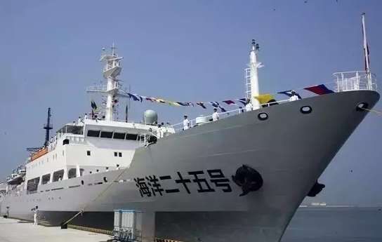
The MNR also oversees the China Geological Survey. Its vessels are active in distant-ocean areas,
though they do not belong to the National Fleet. The China Geological Survey administers the
Guangzhou Marine Geological Survey, owner of several research vessels. Its activities primarily
focus on exploration of seabed resources in Chinese-claimed areas, especially the South China Sea.
However, several of its ships—including the Haiyang 4 and Haiyang 6—routinely operate beyond
the First Island Chain.9 Another China Geological Survey affiliate, the Qingdao Institute of Marine
Geology, owns the 4,350-ton Haiyang Dizhi 9, which was commissioned in late 2017.
Table 2. The China Geological Survey Fleet (Distant-Ocean Vessels)
Owner Ship Name Built Home Port Tons
Guangzhou Marine Geological Haiyang 4 1980 Guangzhou 3,300t
Survey
Haiyang 6 2009 Guangzhou 4,600t
Haiyang Dizhi 8 2017 Guangzhou 6,900t
Haiyang Dizhi 10 2017 Guangzhou 3,400t
Qingdao Institute of Marine Geology Haiyang Dizhi 9 2017 Qingdao 4,350t
Primary Operating Areas
For decades, China’s oceanographic research activities were almost entirely concentrated within the
First Island Chain, in waters often referred to as the “near seas” (近海). These activities were largely
driven by military and sovereignty objectives.10 In the 1980s, China’s civilian research fleet surveyed
remote sections of the South China Sea, laying the foundation for China’s ultimate occupation of
seven land features in the Spratly Islands.11 Beginning in 2002, civilian experts led by the Second
Institute of Oceanography conducted surveys of the East China Sea, collecting data needed to
buttress China’s claim to seabed resources out to the Okinawa Trough—a claim that Japan rejects.12
In September 2003, the State Council approved Project 908, a comprehensive survey and assessment
of all Chinese-claimed maritime space in the near seas. It took over 30,000 scientists and technicians
more than eight years to complete.13
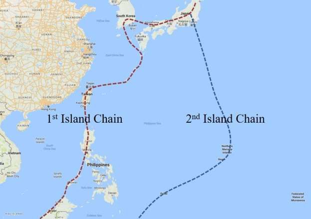
Chinese research vessels have operated beyond the First Island Chain since the 1970s. However, the
current scale of activities is without precedent in Chinese history. A review of China’s oceanographic
research activities in October 2017 illustrates the scale and geography of Beijing’s ambitions.
According to publicly available data, eleven research vessels operated out-of-area in that month:14
China Maritime Report No. 3 4
In early October, Xiang Yang Hong 18 conducted survey operations just north of
Okinotorishima, a Japanese coral feature in the Philippine Sea.
In early October, polar research ship Snow Dragon completed an 83-day Arctic cruise. It
transited Japan’s Tsugaru Strait on October 4th, arriving in Shanghai four days later.15
The first day of October saw the Dong Fang Hong 2 steaming south of Japan’s Kyushu
Island, part of a lengthy cruise that would take it from the high seas of the North Pacific to
Micronesia’s EEZ.
In first half of October, Xiang Yang Hong 10 operated in Micronesia’s EEZ and the U.S. EEZ
southwest of Guam.
In mid-October, COMRA’s Dayang 1 appeared west of Guam, remaining in the Philippine
Sea for two weeks, arriving at its home port of Qingdao on November 1st.
The Guangzhou Marine Geological Survey ship Haiyang 6 spent the first half of October
operating in the high seas north of Micronesia, in waters where China maintains contract
rights with the International Seabed Authority to explore for cobalt rich ferromanganese
crusts.
In the first half of October, and perhaps without precedent, a China Coast Guard cutter
(1307) escorted Xiang Yang Hong 09—the mother ship of the deep-sea submersible
Jiaolong—as it operated in an area west of the Marianas Islands. From October 14-16, the
pair sailed to a position southwest of Guam, within the U.S. EEZ, presumably for diving
operations in the Mariana Trench.
In October, Xiang Yang Hong 03 and Xiang Yang Hong 06 conducted separate surveys of the
Clarion-Clipperton Fracture Zone, an area southeast of Hawaii where China and several other
states possess mineral contract rights under the auspices of the International Seabed
Authority.
In the second half of October, CAS research vessel Kexue operated in the Philippine Sea,
including within the EEZs of Palau and Indonesia.
Xiang Yang Hong 01 spent October operating in the South Atlantic, the third leg of its
circumnavigation of the globe.16
China Maritime Report No. 3 5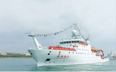
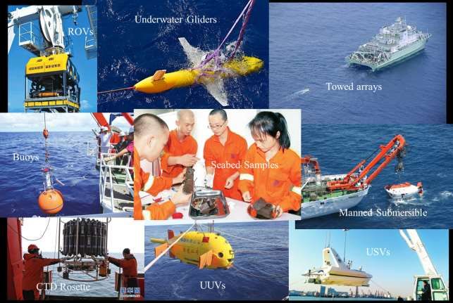
Figure 2 shows a map of Chinese operations in the Western Pacific in October 2017.

The bulk of China’s out-of-area research activities occur in the strategically important waters
between the First and Second Island Chains of the Western Pacific (See Figure 3).17 Some take place
in the large section of high seas in the Philippine Sea, where Chinese vessels can conduct marine
scientific research without permission from any coastal state. Chinese ships also commonly operate
in the huge EEZ of the Federated States of Micronesia and in the EEZ of the U.S. territory of Guam.
The International Seabed Authority has granted China rights to explore for seabed minerals in four
contract zones: two southeast of Hawaii, one east of Guam, and one southeast of Madagascar (see
Figure 4). Much activity observed in distant-ocean areas involves journeys to, from, and within these
contract zones. The Snow Dragon also regularly operates in the polar regions.18

Types of Research Activities

What do China’s oceanographic research vessels do at sea? Many of these ships, especially those
commissioned since 2012, are “comprehensive research vessels,” meaning they can perform a wide
range of research activities, and often do on any given cruise. They principally serve as platforms for
instruments, sensors and other equipment used to collect oceanic and atmospheric data.

Some sensors are attached to the ship. Many vessels, for instance, have “science masts” in the bow
for collecting meteorological data. All have acoustic and other sensors affixed to the hull; the newest
ships, like the Kexue, are fitted with “gondolas”—retractable structures on the bottom of the ship that
prevent bubbles from skewing measurements.19 Acoustic Doppler Current Profilers (ADCPs) direct
sound waves into the water column; returning echoes provide information on the direction and speed
of undersea currents. Multi-beam echo sounders use pulses of sound to obtain precise measurements
of ocean depth. This data can then be used to determine the contours, or bathymetry, of the seabed.
Ships engaged in bathymetric surveys operate in a characteristic “lawn-mower” pattern.

Some sensor are towed behind the ship. The CAS research vessel Shiyan 1, for instance, has a twin-
hull (SWATH) design, ensuring better stability while towing its acoustic array. Several of these
vessels can tow streamers used for seismic surveys. They direct sound waves into the seabed, with
the strength and pattern of returning echoes used to determine the geologic composition of the
subsoil, including potential oil and gas deposits.

China Maritime Report No. 3                                                                           6
Other equipment is lowered into the sea from stationary ships. The CTD rosette, for example,
collects information on the temperature and salinity of the water column at various depths. Since
these factors are associated with many undersea processes, they are key variables in much
oceanographic research.

Chinese research vessels deploy surface and subsurface buoys, which are equipped with instruments
that record environmental data, transmitting it back to China via satellite communications, or storing
it for later recovery and analysis.20 Chinese scientists have deployed indigenously-designed “White
Dragon” surface buoys in the Philippine Sea and Indian Ocean. These units are capable of collecting
and transmitting meteorological and oceanographic information in real-time.21 In 2017, Chinese
researchers moored a subsurface buoy in the northwest section of Micronesia’s EEZ (in the
Challenger Deep trough). This buoy—developed by a team of scientists from Northwest Polytechnic
University, China Ocean University, the CAS Institute of Acoustics, and the First Institute of
Oceanography—is equipped with hydrophones used to study deep-sea sound propagation.22

China’s oceanographic research vessels also host various types of underwater vehicles. The Xiang
Yang Hong 09, for example, deploys the Jiaolong deep-sea submersible, capable of taking Chinese
scientists to the some of the deepest locations in the ocean. Other vehicles are unmanned. These
include remotely-operated vehicles (ROVs) such as the Sea Horse and autonomous underwater
vehicles (AUVs) such as the Qianlong 1, 2, and 3, which are equipped with sensors and cameras to
explore for seabed resources. China’s research vessels also now deploy underwater gliders such as
the Sea Wing. Because of their endurance and economy, gliders make excellent platforms for
measuring basic characteristics of the undersea environment, such as temperature and salinity. In
August-September 2017, Xiang Yang Hong 03 launched two Sea Wing gliders in high seas areas
southeast of Hawaii.23 Chinese scientists have also deployed the Sea Wing in the Philippines EEZ, off
the country’s east coast (see Figure 5).

China’s out-of-area research vessels serve as platforms for the research and development of new
marine equipment and instruments. For example, engineers from a laboratory jointly founded by the
Xi'an Institute of Optics and Precision Mechanics and the Qingdao National Laboratory for Marine
Science and Technology conducted extensive testing of underwater optics technologies during a
2017 cruise to the Mariana Trench.24 The CAS Shenyang Institute of Automation routinely sends
engineers and scientists aboard research vessels heading to distant-ocean areas to test underwater
vehicles. For example, the Institute embarked several personnel aboard the Dayang 1, which left

China Maritime Report No. 3                                                                           7
Qingdao on March 20, 2018, to test the Institute’s new Qianlong 3 AUV in the South China Sea and
Western Pacific.25

Figure 6 shows the range of research activities conducted by China’s distant-ocean research fleet.

Strategic Purposes

China’s deployment of oceanographic research ships and related platforms in distant-ocean areas is
part of a massive program to collect oceanic data. What is the ultimate purpose of this collection
effort? Several interests drive the Chinese government’s investment in out-of-area oceanographic
research.26 Two of the main drivers have the greatest significance for U.S. national security. These
include a desire to 1) explore, and ultimately exploit, seabed resources in high seas areas and 2)
support the development of China’s blue-water naval capabilities. While not a major driver, Chinese
oceanographers also serve political functions for the Chinese party-state: as ambassadors of good
will, and tools with which to assert China’s maritime rights and interests.

        Seabed Resources

Interest in seabed resources is a big—perhaps the biggest—driver behind China’s distant-ocean
survey operations.27 PRC leaders regard international seabed areas as a potential source of minerals
to support China’s future economic development. This logic was summarized by State Oceanic
Administration Director Liu Cigui in remarks to China’s representative to the International Seabed
Authority in late 2013. Liu told Ambassador Dong Xiaojun, “China possesses a long coastline, vast
maritime space, and rich marine resources. But per capita endowments are low. To ensure the
sustainable development of our economy, we must continue to expand our maritime development
space. We must focus on the 250 million km2 of high seas. For the sake of future generations, we
must vie for more marine resources and maritime rights.”28 As this passage suggests, Chinese
discourse often regards seabed resource exploration and exploitation as a competition between states.
Much of China’s activities are driven by a desire to be the first country to commercially exploit
international seabed resources, and lead the industry.29

Marine science is closely entwined with the PRC’s strategic objective of transforming China into a
“maritime power” (海洋强国), which is largely an economic concept. This aim, first articulated in a
2003 planning document, was famously emphasized in Hu Jintao’s 18th Party Congress Work Report
(November 2012).30 Hu outlined the four key components of China’s maritime power strategy:

China Maritime Report No. 3                                                                            8
marine resources, the ocean economy, marine environmental protection, and maritime rights and
interests.31
Chinese leader Xi Jinping has personally expressed his commitment to explore and exploit seabed
resources in high seas areas. At a July 2013 Politburo meeting about China’s maritime power
strategy, Xi declared that China must “thoroughly perform ocean and polar scientific survey work,
perform deep-sea and distant-ocean survey research, expand international cooperation in marine
science and technology, and make preliminary preparations for exploiting ocean and polar
resources.”32 In a May 2016 speech at a national convention on scientific and technological
innovation, Xi again singled out the importance of deep-sea resources: “The deep sea contains
earthly treasures that aren’t remotely understood or developed. But if we want to obtain these
treasures, then we must master key technologies for entering the deep sea, surveying the deep sea,
and developing the deep sea.”33
The PRC is engaged in a whole-of-government effort to pursue commercial exploitation of seabed
resources in high seas areas.34 China currently possesses contract rights under the auspices of the
International Seabed Authority to explore for seabed resources in four separate zones. 35 Quasi-
governmental agency COMRA represented China in the first three contracts. The most recent
contract, signed in May 2017, was concluded by China Minmetals Corporation, a mining company.36
In February 2016, China passed the PRC Law on Exploration and Development of Resources in
Deep Sea Seabed Areas, aimed at laying the institutional foundation for the country’s move from
seabed resource exploration to resource exploitation.37
Table 3. Chinese Contracts to Explore for Seabed Resources in High Seas Areas
# Contract PRC Contract Party Location of Contract Resource Type
Period Zone
1 2001-2016, COMRA Clarion Clipperton Polymetallic nodules
2016-2021 Fracture Zone
(renewed)
2 2011-2026 COMRA Southwest Indian Ridge Polymetallic sulphides
3 2014-2029 COMRA Western Pacific Ocean Cobalt-rich ferromanganese crusts
4 2017-2032 China Minmetals Clarion Clipperton Polymetallic nodules
Fracture Zone
China Maritime Report No. 3 9China’s oceanographic research fleet serves on the front lines in this effort. Vessels conduct high-
resolution bathymetric surveys of high seas areas with potential deposits of seabed minerals, using
shipboard multi-beam echo sounders and new-generation UUVs for this purpose. In July 2018, for
instance, Xiang Yang Hong 10 completed a 250-day cruise to the Indian Ocean, during which it
surveyed part of COMRA’s 10,000 km2 contract zone in the Southwest Indian Ocean. The crew
deployed the UAV Qianlong 2, which conducted nine dives for a total of 257 hours.38 Data collected
during these types of surveys inform Chinese decisions about where to apply for future contract
rights, and which sections of existing contract zones merit additional focus. Aside from exploring for
seabed resources, Chinese research vessels also perform biologic surveys of areas contract zones, as
required under International Seabed Authority rules.
Naval Strategy39
During the command of Admiral Wu Shengli (2006-2017), the People’s Liberation Army Navy
(PLAN) dramatically expanded the content and geographic scope of its operations. No longer fixated
on preparing for and deterring war, the service came to embrace the diverse set of non-combat
missions for which navies are uniquely suited.40 Many of these operations took place in waters
beyond the First Island Chain, in what Chinese strategists call the “far seas” (远海).41 In 2008, the
PLAN sent its first task force to the Indian Ocean for anti-piracy operations off the Horn of Africa, a
watershed moment which, less than ten years later, resulted in the opening of China’s first overseas
base (in Djibouti).42 Beijing has used the PLAN in other non-combat roles, such as assisting
international efforts to dispose of Syria’s chemical weapons (2014), searching for missing Malaysian
airlines flight 370 in the Indian Ocean (2014), evacuating Chinese citizens from Yemen (2015),
holding joint exercises with Russia and other countries, and making countless port visits throughout
the Indo-Pacific.
The PLAN’s interest in the far seas is not confined to non-combat operations. During Admiral Wu’s
tenure, it also started conducting deployments and training to prepare the service to fight in the far
seas.43 Many conflict scenarios in East Asia could lead to hostilities between China the United States.
The U.S. Navy’s long-range precision strike capabilities, amply demonstrated during the conflicts of
the 1990s, have created a strong impetus for the PLAN to develop the ability to engage U.S. forces
beyond the First Island Chain—well before they arrive in theater.44 As a result, the ocean space
between the First and Second Island Chains has assumed great importance for Chinese naval
strategy.
China Maritime Report No. 3 10The geographic expansion of Chinese naval operations has created intense demands to speed mastery
of the “ocean battlespace environment” (海战场环境) in new ocean areas. Some of these demands
are met by the PLAN itself. The Chinese Navy, like the U.S. Navy, possesses a corps of
meteorologists and oceanographers that support the fleet. The PLAN operates a number of Type
636/636A distant-ocean survey ships, analogues of the U.S. Navy’s Pathfinder class hydrographic
survey ships. These ships perform bathymetric surveys and collect oceanographic and meteorological
data, which serve as inputs for the production of charts and the development and improvement of
forecasting systems. Indeed, the PLAN’s distant-ocean survey fleet has more than tripled since 2015.
Table 4 lists key elements of this fleet. Figure 7 shows PLAN distant-ocean survey ship Haiyang 25.
Table 4. The PLAN’s Distant-Ocean Survey Fleet45
Hull Number Name Built
Haiyang 20. Zhu Kezhen 2003
Haiyang 22 Qian Sanqiang 2008
Haiyang 23. Qian Xuesen 2015
Haiyang 24. Deng Jiaxian 2016
Haiyang 25. Qian Weizhang 2016
Haiyang 26 Chen Jingrun 2016
Haiyang 27 Wang Ganchang 2017
Haiyang 28 Zhu Guangya 2017
Haiyang 29. Mao Yisheng 2018
Oceanographers at civilian agencies and research institutes support the PLAN in a number of ways.
They share information, such as bathymetric data needed in the creation of charts. When the PLAN
began to routinize far seas operations, its knowledge of ocean areas beyond the First Island China
was extremely limited.46 To remedy this problem, the PLAN sought to leverage the data and
expertise resident in the Ministry of Land and Resources (predecessor of the current MNR). In
January 2009, the two signed the Agreement between the Ministry of Land and Resources and the
People’s Liberation Army Navy on Strengthening Geologic Surveying and Marine Mapping.47
Civilian oceanographers also support the PLAN through their efforts to model oceanic processes.
Especially important are the dynamic elements of the ocean battlespace environment, such as surface
and subsurface currents, tides, and surface and subsurface waves. These and related factors—such as
ocean temperature, density, and salinity—directly affect all manner of naval operations, from basic
China Maritime Report No. 3 11navigation to amphibious landings. Militaries that are more aware of current conditions and better able to predict future conditions have an advantage over their adversaries. In the words of one PLAN analyst, “the side with fuller, more accurate, and timelier mastery of the ocean battlespace environment will have the initiative on the battlefield.”48 Civilian oceanographers develop models for understanding oceanic phenomena. These models can then be applied to the development of combat systems and tactics needed by the fleet. The study of the dynamic ocean is especially important for undersea warfare. Temperature is a key factor affecting underwater sound propagation. The ability to know and predict the location of currents, eddies, and other oceanic phenomena confers an advantage to submarine commanders seeking to elude detection.49 To maximize the performance of sonar and other systems used to detect foreign submarines, navies must develop accurate oceanographic models for all of the ocean areas where they intend to operate. Chinese oceanographers are heavily funded to conduct research on the physical oceanography of the Philippine Sea. Their work helps the PLAN master the ocean battlespace environment in this strategically-vital ocean space. The Qingdao National Lab—in conjunction with the MNR and CAS—is leading an enormous project to build an integrated network of fixed and mobile sensors to monitor the undersea conditions in the Western Pacific, South China Sea, and the Indian Ocean. The evocatively-named “Transparent Ocean Project” is intended to achieve the ability to conduct large- scale, real-time ocean observation. Project scientists are developing models for understanding—and ultimately predicting—the dynamic undersea environment. Project funders and participants openly acknowledge the security objectives driving their scientific work.50 Though the network is still being developed, existing infrastructure is already serving the oceanographic needs of the PLAN. Data collected from sea-based sensors is shared with the MNR’s National Marine Environment Forecasting Center, which in turn supplies oceanographic and meteorological products to the PLAN.51 Like the Qingdao National Lab, the MNR conducts research to support China’s naval development. The First Institute of Oceanography describes its mission as “promoting progress in marine science and technology to serve management of the marine environment and marine resources, maritime national security, and marine economic development” (emphasis added).52 When Xiang Yang Hong 01 was commissioned in 2016, authoritative sources stated that its various tasks would include “comprehensive observation in the field of military oceanography.”53 The Third Institute of China Maritime Report No. 3 12
Oceanography likewise performs “military oceanography” and “projects for national defense
construction.”54 Research conducted by MNR entities is likely coordinated and shared with the
PLAN by means of mechanisms set up in 2009. In January of that year, the State Oceanic
Administration signed a major cooperative agreement with the PLAN, including provisions for
cooperation in marine science.55 The relationship between the two deepened as a result of a second
cooperative agreement signed in April 2017, intended to “further promote civil-military integrated
development in the maritime realm, and support the construction of a world-class navy.”56

Given the significant degree of civil-military integration in marine science, at least some Chinese
distant-ocean cruises involve activities more akin to “military surveys.” 57 That is, embarked scientists
are collecting data primarily intended to serve military aims, not “in order to increase scientific
knowledge of the marine environment for the benefit of all mankind,” as marine scientific research is
defined in the United Nations Convention on the Law of the Sea.58 China’s close civil-military
integration differs markedly from the U.S. approach of clearly distinguishing between military
surveys—which are only conducted by U.S. Navy special mission ships—and marine scientific
research, done by civilian academics aboard civilian-operated vessels.

Despite these known ties between the PLAN and civilian research institutes, civil-military integration
in marine science is far from perfect. Synergy is the ideal, not necessarily the reality. Chinese experts
in positions of authority candidly acknowledge shortcomings. For example, at the March 2018
legislative sessions in Beijing, State Oceanic Administration official Zhang Haiwen suggested a
degree of disappointment with achievements to date: “In recent years, there has been lots of
cooperation between the military and civilians, but in the marine field there are many more aspects of
civil-military integration that can be further developed, such as information sharing and ocean
monitoring, among others.59 Still, Chinese leaders recognize the problems and are taking steps to
remedy them. The April 2017 cooperative agreement (discussed above) was a step in that direction.60

        Maritime Diplomacy

China’s distant-ocean survey activities serve political functions. Chinese leaders employ research
platforms as tools of maritime diplomacy, both cooperative and competitive. Out-of-area marine
scientific research helps protect the PRC’s maritime rights and interests. According to a 2017 article
published under the byline of the State Oceanic Administration Party Committee, “China not only
possesses sovereignty, sovereign rights, and jurisdiction over three million square kilometers of

China Maritime Report No. 3                                                                           13
claimed jurisdictional maritime space. It also has extensive and broad maritime rights and interests in the polar regions, deep-sea areas, and other ocean areas.” 61 Chinese policymakers believe that maintaining a claim to these rights requires research activities to assert them. In March 2013, Haiyang 6 departed Guangzhou for a cruise to the eastern Pacific, presumably the Clarion-Clipperton Fracture Zone, to conduct resource, environmental, and biological surveys. An article published in a State Oceanic Administration periodical declared that the overarching purpose of the mission was to “safeguard China’s mineral resource rights and interests in international seabed areas.” 62 Guided by this mode of thinking, Chinese leaders could sanction, or perhaps even direct, the operations of oceanographic research vessels to challenge the excessive claims of other coastal states. The October 2017 operations of the Xiang Yang Hong 18 near Japan’s Okinotorishima (cited above) may have in part been motivated by such political considerations. China’s research fleet is also used as a tool of cooperative diplomacy. This function likely gained new impetus from the 21st Century Maritime Silk Road, Beijing’s ambitious initiative to bolster political and economic ties between China and countries rimming the Indian Ocean. In June 2017, China issued the Vision for Maritime Cooperation under the Belt and Road Initiative, which highlights cooperation in marine scientific research between China and countries along the 21st Century Maritime Silk Road.63 When abroad, vessels must periodically stop in foreign ports to take on fuel and provisions, make repairs, and swap out crew members. At these times, the vessels often host foreigner visitors, especially foreign scientists and civilian administrators. For example, from 18-22 April 2016 the CAS South China Sea Institute of Oceanology vessel Shiyan 1 docked in Colombo, Sri Lanka for replenishment after completing the first half of a cruise in the eastern part of the Indian Ocean. While in Colombo, faculty, students, and administrators from the University of Ruhuna were invited to tour the ship.64 Sometimes Chinese research vessels are tasked to help other countries survey their own jurisdictional waters. For example, the Second Institute of Oceanography has signed a number of agreements with Indian Ocean countries to help them survey their continental shelves. In June 2016, scientists aboard Xiang Yang Hong 10 conducted seismic and bathymetric surveys of the continental shelves of Mozambique and Seychelles. Lead scientist, Tang Yong, said that this cruise would enable China to “accumulate precious experience for engaging in international cooperation in the field of marine China Maritime Report No. 3 14
surveys and lay a foundation for deepening China-Africa cooperation in the field of marine science
and technology.”65

Aside from providing intangible political benefits, cooperation in marine science ensures Chinese
access to strategically-important ocean areas within other states’ EEZs.66 The Qingdao National Lab,
for instance, has conducted joint research with the Maldives Bureau of Meteorology on the physical
oceanography of waters adjacent to the Maldives. They performed two cruises, one from October-
November 2015 and the second in September 2017, during which they observed ocean temperature,
salinity, and currents using shipboard instruments. They also jointly deployed at least one subsurface
mooring.67

Implications

China’s out-of-area oceanographic research activities raise a number of concerns for U.S.
policymakers. The scale of Beijing’s investment in these operations now dwarfs that of any other
country, including the United States. When it was set up in 2012, the National Fleet comprised just
19 vessels.68 By the end of 2017, it had expanded to 50 ships, half classed as distant-ocean capable.69
This number does not include the five large hulls owned by the China Geologic Survey. The fleet
continues to expand. As of September 2017, ten other oceanographic research vessels were in various
stages of design and construction.70 The Chinese government is also funding development of a
catalog of other research platforms, including manned submersibles, AUVs, and surface and
subsurface moorings. China’s expanding investment contrasts markedly with declining government
support for marine science in the U.S.71 America’s UNOLS fleet possesses only nine large ships,
over half of which were commissioned more than twenty years ago. 72

Marine science is a key pillar of U.S. naval power. In their quest for truth, civilian oceanographers
create knowledge that can be translated into new systems, platforms, and tactics used by the fleet.
They are a source of ideas and insights that can help solve problems facing the military, both in
wartime and peacetime.73 They also educate the men and women who serve the military, as active
duty meteorologists and oceanographers, U.S. Navy scientists, and researchers in private industry.
America’s comparative neglect of marine science risks ceding the great discoveries of the future to a
strategic competitor, and weakening the U.S. oceanographic community just when it is most needed.

China is also pursuing a far more robust degree of civil-military integration than currently exists in
the U.S. Beijing has mobilized civilian scientists to directly serve military aims. The State Oceanic

China Maritime Report No. 3                                                                              15
Administration—now the Ministry of Natural Resources—is the biggest player in Chinese distant-
ocean research. Since 2009, it has worked closely with the PLAN to help lay the foundation for the
PLAN’s transformation into an oceanic navy. The Chinese Academy of Science and the Qingdao
National Lab also conduct research on behalf of the PLAN. Beijing’s approach to civil-military
integration in marine science makes it difficult for the U.S. to fully appreciate the naval significance
of Chinese collection operations.74

While the quantity of China’s distant-ocean research is unsurpassed, the quality of marine science in
the PRC still trails that of the U.S. In a February 2018 interview, renowned acoustician Yang Desen
from the Harbin Engineering University lamented China’s comparative lack of basic research,
paucity of basic data, and shortfall of well-trained scientists.75 PLAN scientist Da Lianglong
expressed similar views in March 2018. China’s basic marine research remains derivative: Chinese
scientists still tend to “follow and imitate others.” Truly innovative research is rare, and a gap
remains between China and the world’s maritime powers.76 However, given all that China has
achieved in the last fifteen years, U.S. policymakers would be foolish to assume Beijing cannot
overcome these challenges.

China’s distant-ocean survey activities may be a leading indicator of China’s evolving naval strategy.
They portend a future in which PLAN warships and submarines routinely operate on all the world’s
great oceans. This is true not just because Chinese research ships are laying the scientific foundation
for naval operations in new areas. They are also preparing for future activities to exploit seabed
resources, which the Chinese Navy will be asked to protect. Indeed, international maritime space
constitutes one of the new frontiers in Chinese national security thinking. The 2015 Science of
Military Strategy—an authoritative volume published by China’s National Defense University—
highlights “military struggle in the deep sea.” The authors identify China’s “international sea bed
resource extraction interests” as a key source of future insecurity. 77 The July 2015 revision to China’s
National Security Law added new text about the need to “safeguard the security of our nation’s
activities, assets, and other interests in…international seabed areas.”78 China possesses seabed
contract rights in strategically important locations: east of Guam and southeast of the Hawaiian
Islands. If China moves to exploit resources in these areas, it could justify decisions to bolster
Chinese naval presence.79

China’s distant-ocean survey activities also serve political purposes. These functions are subsidiary
to the economic and military drivers discussed above. Still, their efforts to forge closer ties with other

China Maritime Report No. 3                                                                            16
coastal states in the Indo-Pacific could create good will that Beijing can leverage in times and
circumstances where U.S. and Chinese interests collide. These interactions also allow China to
promote its views on the international maritime order, which differ markedly from those held in the
U.S.

This report addresses basic questions about China’s distant-ocean marine science. In doing so, it has
raised many new ones. Future work should closely examine specific civilian research projects. What
questions are Chinese scientists seeking to answer? Which oceanic phenomena are of greatest
interest? What instrument and techniques are they using to answer these questions? Follow-on
research should seek a far more detailed understanding of relationships between civilian research
institutes and the PLAN. What funding arrangements exist between the Chinese military and the
MNR, CAS, and the Qingdao National Lab? How are data and findings shared? How does the work
of civilian scientists and engineers get translated to the production of hardware, systems, and tactics
used by the PLAN? These questions, and many others, must be satisfactorily answered before we can
fully grasps the risks and challenges presented by Beijing’s growing interest in distant-ocean marine
science.

China Maritime Report No. 3                                                                           17
APPENDIX

               Figure 1. Key Members of China’s Distant-Ocean Research Fleet

                                          Kexue

                                   Xiang Yang Hong 01

                                        Dayang 1

China Maritime Report No. 3                                                    18
Figure 2. Chinese Survey Operations in the Western Pacific (October 2017)80 China Maritime Report No. 3 19
Figure 3. The “Island Chains”

China Maritime Report No. 3                                   20
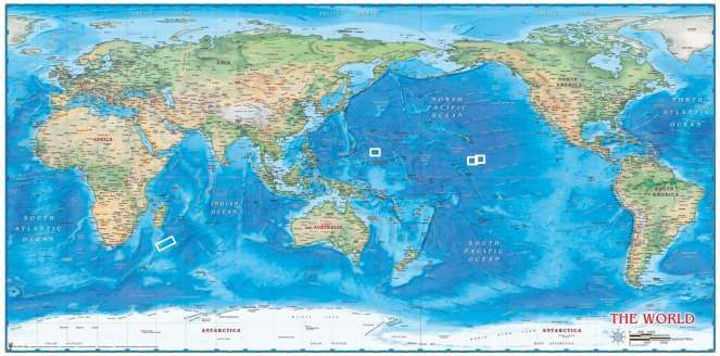
Figure 4. The Location of China’s Contract Zones with the International Seabed Authority

China Maritime Report No. 3                                                                   21
Figure 5. Company Brochure for the Sea Wing (showing operations in the Philippines EEZ)81

China Maritime Report No. 3                                                              22
Figure 6. Activities of China’s Distant-Ocean Research Fleet

China Maritime Report No. 3                                                    23
Figure 7. PLAN Distant-Ocean Survey Ship Haiyang 25

China Maritime Report No. 3                                             24
NOTES
1
 The views expressed here are the authors’ alone. They do not represent the estimates or policies of the U.S. Navy
or any other organization of the U.S. government. The authors thank Jay Batongbacal, Bill Murray, Paul Schmitt,
and Kathleen Walsh for their suggestions and insights. The authors accept sole responsibility for any errors or
shortcomings.
2
 The legislation says that the Ministry of Natural Resources will retain the State Oceanic Administration “brand”
(牌子), but it is unclear what that means in practice. 深化党和国家机构改革方案 [Plan for Deepening Reform of
Party and State Structures] 新华 [Xinhua] March 21, 2018, www.gov.cn/zhengce/2018-
03/21/content_5276191.htm#1
The MNR inherited the State Oceanic Administration’s responsibility for “organizing and carrying out marine
scientific surveys and investigations.” For information on its other marine-related functions, see 自然资源部职能配
置、内设机构和人员编制规定 [Regulations Regarding the Functional Configuration, Organization, and Staffing
of the Ministry of Natural Resources] 自然资源部网站 [Website of the Ministry of Natural Resources]
www.mlr.gov.cn/bbgk/sdfa/
3
    For a useful discussion about the rationale for creating the National Fleet, see 朱建华, 李尉尉, 徐伟 [Zhu Jianhua,
Li Weiwei, and Xu Wei] 建立国家海洋调查船队的思考 [“Thoughts on Establishing a National Marine Research
Fleet] 海洋开发与管理 [Ocean Development and Management] 2012, No. 9, pp. 6-9.
4
 The Commission includes representatives from the National Development and Reform Commission, Ministry of
Education, Ministry of Science and Technology, Ministry of Finance, and the Chinese Academy of Science. 国家海
洋调查船队协调委员会 [Coordination Commission of the National Marine Research Fleet] 国家海洋调查船队
[Website of the National Marine Research Fleet] www.cmrv.org/home/plus/list.php?tid=13.
5
 陆琦 [Lu Qi] 国家海洋调查船队成立 [“The National Marine Research Fleet Has Been Founded”] 中国科学报
[China Science Daily] April 19, 2012, http://news.sciencenet.cn/htmlnews/2012/4/262901.shtm
6
    张建松, 岑志连 [Zhang Jiansong and Qin Zhilian] “实验 3”号科考船上的“巴铁”科学家 [“‘Pakistan Friend’
Scientists Board the Scientific Research Vessel ‘Shiyan 3’”] 新华 [Xinhua] January 21, 2018,
http://sh.xinhuanet.com/2018-01/21/c_136911999.htm
7
 The “high seas” comprise all waters outside of coastal state jurisdiction. See United Nations Convention on the
Law of the Sea, Article 86.
8
    Information in this table comes from 国家海洋调查船队 [“Profile of China’s Marine Research Fleet”] 国家海洋
调查船队 [Website of the China Marine Research Fleet], http://www.cmrv.org/home/plus/list.php?tid=1
9
 The “First Island Chain” refers to the archipelago stretching from Japan to Indonesia via Taiwan, the Philippines,
Malaysia, and Brunei. See 中国人民解放军军语 [PLA Dictionary of Military Terms] (Beijing: Academy of
Military Science Press, September 2011), p. 952.
10
     韩永 [Han Yong] 科考:从“海”到“岛” [“Scientific Investigation: Moving from the ‘Seas’ to the ‘Oceans’”] 中
国新闻周刊 [China Newsweek] November 26, 2012, pp. 32-35. From the late 1970s to the late 1990s, Chinese
oceanographic research operations were guided by the mantra “thoroughly survey the China seas, make advances in
the three oceans, and land on Antarctica” (查清中国海、进军三大洋、登上南极洲). This objective was declared
at the State Oceanic Administration’s December 1977 National Planning Meeting for Marine Science and
Technology. 刘明 [Liu Ming] 党的十八大以来中国海洋科技发展政策 [“China’s Marine Sci-Tech Development
Policy Since the 18th Party Congress”] 中国海洋报 [China Ocean News] October 26, 2017, p. 2.

China Maritime Report No. 3                                                                                        25
11
John W. Garver, “China's Push through the South China Sea: The Interaction of Bureaucratic and National
Interests,” The China Quarterly, No. 132 (Dec., 1992), pp. 999-1028.
12
周超 [Zhou Chao] 用科研力量“主张”海洋权益--国家海洋局第二海洋研究所外大陆架划界工作 [“Use the
Power of Scientific Research to ‘Claim’ Maritime Rights and Interests—On the Second Institute of Oceanography’s
Work on the Extended Continental Shelf Boundary Delimitation”] 中国海洋报 [China Ocean News] February 26,
2016, p. 3. 中国东海部分海域二百海里以外大陆架划界案访谈 [“Discussion on China’s Project for Delimiting a
Continental Shelf Extending Beyond 200 Nautical Miles in Some Parts of the East China Sea”] 中央政府网站
[Website of the Government of the PRC] August 16, 2013, http://www.gov.cn/gzdt/2013-
08/16/content_2467982.htm
13
朱彧 [Zhu Yu] “908 专项”实施具有里程碑意义——访国家海洋局党组成员、副局长陈连增 [“The
Implementation of ‘Project 908’ was a Significant Milestone—An Interview with State Oceanic Administration
Party Committee Member and Deputy Director, Chen Lianzeng”] 中国海洋报 [China Ocean News] October 29,
2012, p. 6.
14
The International Convention for the Safety of Life at Sea (SOLAS) requires all vessel larger than 300GT on
international voyages to use the automatic identification system (AIS). When operating beyond the First Island
Chain, PRC research vessels often transmit AIS. See Website of the International Maritime Organization,
www.imo.org/en/OurWork/Safety/Navigation/Pages/AIS.aspx
All AIS data cited in the report come from www.marinetraffic.com
“China’s Ice Breaker Returns after First Arctic Rim Circumnavigation,” Global Times, October 10, 2017,
15
www.globaltimes.cn/content/1069635.shtml
“向阳红 01”科考船起航执行中国首次环球海洋综合科考 [“Research Vessel ‘Xiang Yang Hong 01’ Departs for
16
China’s First Global Comprehensive Marine Survey”] 海洋世界 [Ocean World] 2017, No. 9, pp. 6-9.
17
According to the PLA Dictionary of Military Terms, the Second Island Chain extends from the Japanese home
islands to Indonesia’s Halmahera and includes the Bonin Islands, Iwo/Volcano Islands, Mariana Islands, Yap
Islands, and Palau Islands. See PLA Dictionary of Military Terms, pp. 952-953.
18
For a very rich analysis of China’s activities in the polar regions, see Anne-Marie Brady, China as a Polar Great
Power (Cambridge: Cambridge University Press, 2017).
19
王晶 [Wang Jing] “该船的探测能力世界一流” [“‘That Ship’s Survey Capabilities are World-Class’”] 中国海洋
报 [China Ocean News] October 19, 2012, p. 3.
20
In February 2017, a team of scientists embarked on the Kexue completed China’s first “deep-sea, real-time
scientific observation network” comprising 20 submerged buoys. Located in the Western Pacific, this network
collects environmental information (temperature, salinity, and ocean current speed/direction) down to 3,000 meters,
transmitting the data to China by satellite once every hour. Chinese scientists can access the data from apps on their
cell phones. 张旭东 [Zhang Xudong] 我国首个深海实时科学观测网在西太平洋建成 [“China’s First Deep-Sea
Real-Time Scientific Observation Network Is Set Up in the Western Pacific”] 新华 [Xinhua] February 7, 2018,
www.xinhuanet.com/tech/2018-02/07/c_1122382482.htm
21
高倩 [Gao Qian] 十年,引领深海综合观测系统技术创新—“白龙浮标”实现深海海洋气候实时观测 [“Ten
Years, Leading Deep-Sea Comprehensive Observation System Technology Innovation—The ‘White Dragon
Surface Buoy” Achieves Real-Time, Deep-Sea Ocean Climate Observation”] 青岛海洋科学与技术试点国家实验
室 [Website of the Qingdao National Laboratory of Marine Science and Technology] May 5, 2017,
www.qnlm.ac/page?a=5&b=1&c=5&d=3&p=detail
22
郑雅楠] [Zheng Ya’nan] 我科学家首次听到海洋最深处声音: 在马里亚纳海沟布放万米全水深观测潜标
[“Chinese Scientists Hear Sounds from the Deepest Part of the Ocean for the First Time: They’ve Deployed a
China Maritime Report No. 3 2610,000-Meter Whole-Depth Observation Buoy in the Mariana Trench”] 中国海洋报 [China Ocean News]
December 28, 2017, p. 2.
23
“海翼”水下滑翔机完成大洋第 45 航次观测任务 [“The ‘Sea Wing’ Glider Completes Observation Task as Part
of the 45th Ocean Cruise”] 中国科学院网站 [Chinese Academy of Science Website] September 4, 2017,
http://www.cas.cn/zkyzs/2017/09/117/yxdt/201709/t20170905_4613336.shtml
24
The team tested an advanced underwater camera at depths of 7,000 and 10,000 meters. 张潇 [Zhang Xiao] 让西
安成为“海上丝绸之路”的技术起点 ——西安“水下光学”硬科技全国领先 中科院西安光机所副所长李学龙
[“Let Xi’an Become the Technological Starting Point of the ‘Maritime Silk Road’—Xi’an’s ‘Underwater Optics
Science and Technology Leads the Country, Says Deputy Director Li Xuelong”] 中国科学院西安光学精密机械研
究所 [Website of the CAS Xi'an Institute of Optics and Precision Mechanics ] February 13, 2018,
http://opt.cas.cn/xwzx/tpxw/201802/t20180213_4951641.html
25
陈灏 [Chen Hao] “大洋一号”青岛起航 “潜龙”“海龙”将双双入海 [“‘Dayang 1’ Departs from Qingdao,
‘Qianlong’ and ‘Hailong’ Go Along] 新华 [Xinhua] March 20, 2018, www.xinhuanet.com/tech/2018-
03/20/c_1122563001.htm
In late 2015, Xiang Yang Hong 10 took the Qianlong 1 and 2 on a research mission to the southwestern Indian
Ocean. To “ensure the smooth completion of the tasking,” ten scientists from the CAS Shenyang Institute of
Automation embarked with the ship. 沈阳自动化所两台大深度 AUV 将同时赴西南印度洋参加大洋第 40 航次
科考任务 [Two Deep-Sea AUV’s Designed By Shenyang Institute of Automation Will Head to the Southwest
Indian Ocean to Participate in the 40th Scientific Cruise”] 中国科学院沈阳自动化研究所网站 [Website of the CAS
Shenyang Institute of Automation] November 5, 2015,
www.sia.cas.cn/xxgk/szs/kxyj/kyjz/201511/t20151127_4474824.html
26
It is important to distinguish between the motives animating individual scientists—which vary, and are deeply
personal—and the motives of the state. This study only considers the latter.
27
For early reporting on China’s decision to heavily invest in marine science, and the economic drivers behind this
decision, see Jane Qiu, “China outlines deep-sea ambitions,” Nature Online, 6 July 2010,
www.nature.com/news/2010/100706/full/466166a.html?s=news_rss
28
This quote comes from an “internal publication” (内部刊物) now publicly available on the State Oceanic
Administration website. See 康明乐 [Kang Mingle ] 国家海洋局局长刘赐贵会见我驻牙买加大使董晓军 [“State
Oceanic Administration Director Liu Cigui Meets with China’s Ambassador to Jamaica, Dong Xiaojun”] 国际海洋
合作 [International Marine Cooperation] 2013, No. 5, P. 12,
www.soa.gov.cn/bmzz/jgbmzz2/gjhzsgatbgs/201303/P020170118564524494372.pdf
29
Chinese analysts and policymakers often describe the perceived competition for resources in international seabed
areas as a “new ocean enclosure movement.” See, for example, 国家海洋局党组书记、局长刘赐贵在中国大洋协
会成立二十周年庆祝大会上的讲话 [“Speech by State Oceanic Administration Party Secretary and Director Liu
Cigui at Celebration Commemorating the 20th Anniversary of the Founding of COMRA”] 国家海洋局 [State
Oceanic Administration Website] October 20, 2011,
www.soa.gov.cn/xw/dfdwdt/jsdw_157/201211/t20121108_16409.html
30
The State Council’s Outline for the National Marine Economy Development Plan (2003) called for China to
“gradually build itself into a maritime power.” See 国海洋经济发展规划纲要 [Outline for the National Marine
Economy Development Plan] 国家海洋局网站 [Website of the State Oceanic Administration] May 9, 2003,
www.soa.gov.cn/zwgk/fwjgwywj/gwyfgwj/201211/t20121105_5261.html
China Maritime Report No. 3 2731
胡锦涛在中国共产党第十八次全国代表大会上的报告 [Hu Jintao’s Report at the 18th Congress of the Chinese
Communist Party], 新华 [Xinhua] November 17, 2012, www.xinhuanet.com/18cpcnc/2012-11/17/c_113711665.htm
32
习近平同志在中共中央政治局第八次集体学习时的讲话 (2013 年 7 月 30 日) [“Xi Jinping’s Speech at the
CCP Politburo’s 8th Collective Study Session (July 30, 2013)”] 《太平洋学报》 [Website of Pacific Journal]
www.pacificjournal.com.cn/CN/news/news263.shtml
33
习近平 [Xi Jinping] 为建设世界科技强国而奋斗——在全国科技创新大会、两院院士大会、中国科协第九
次全国代表大会上的讲话 (2016 年 5 月 30 日)[“Struggle to Build China Into a World Sci-Tech Power”—
Speech at the National Sci-Tech Innovation Meeting, Meeting of the Two Academies, and the 9 th Congress of the
China Association of Science and Technology (May 30, 2016)] 新华 [Xinhua] May 31, 2016,
www.xinhuanet.com/politics/2016-05/31/c_1118965169.htm
34
In April 2017, China issued the 13th Five Year Plan for Resource Exploration and Development in Deep-Sea
Seabed Areas (《深海海底区域资源勘探与开发“十三五”规划).This plan is not publicly available. See 王宏
[Wang Hong] 深海法助力我国建设海洋强国 [“Deep Sea Law Helps China Become a Maritime Great Power”], 法
制日报 [Legal Daily] May 3, 2017, www.legaldaily.com.cn/government/content/2017-05/03/content_7131307.htm
35
China has a Permanent Mission to the International Seabed Authority, which produces a periodical called
International Seabed Information. Past issues of the periodical are available at 中华人民共和国常驻国际海底管理
局代表处网站 [Website of the Permanent Mission of the PRC to the International Seabed Authority] http://china-
isa.jm.china-embassy.org/chn/dbcxx/dbckw/gzhdxx/
36
“China Minmetals Corporation Signs Exploration Contract with the International Seabed Authority,” Website of
the International Seabed Authority, May 12, 2017, www.isa.org.jm/news/china-minmetals-corporation-signs-
exploration-contract-international-seabed-authority
37
中华人民共和国深海海底区域资源勘探开发法 [PRC Law on Exploration and Development of Resources in
Deep-Sea Seabed Areas] 新华 [Xinhua] February 26, 2016, www.xinhuanet.com/politics/2016-
02/26/c_1118175002.htm
38
中国大洋 49 航次科考满载而归 [“China’s 49th Ocean Research Cruise Returns with a Full Load”] 中华人民共
和国中央人民政府 [Website of the Central Government of the PRC] August 13, 2018, www.gov.cn/xinwen/2018-
08/13/content_5313507.htm
39
The PLA Dictionary of Military Terms defines “naval strategy” (海军战略) as “the policies (方针) and approach
(策略) for planning and guiding the overall construction and employment of the navy.” See PLA Dictionary of
Military Terms, p. 888.
40
This theme was highlighted in the 2013 National Defense White Paper. Information Office of the State Council,
The Diversified Employment of China's Armed Forces, April 2013. See also 吴胜利,刘晓江 [Wu Shengli, Liu
Xiaojiang] 建设一支与履行新世纪新阶段我军历史使命要求相适应的强大的人民海军—庆祝中国人民解放军
海军成立 60 周年 [“Build a Powerful People’s Navy That Is Compatible With the Requirements for the Military to
Perform Historic Missions in the New Age and New Period”] 求是杂志 [Qiushi] No. 9, 2009, pp. 8-9. See also 吴
胜利, 刘晓江 [Wu Shengli, Liu Xiaojiang] 牢记千钧重托 不负护航使命——写在人民海军执行远洋护航任务两
周年之际 [“Keep Firmly in Mind the Heavy Responsibility and Do Not Fail the Escort Mission—Written on the
Occasion of the Second Anniversary of the People’s Navy’s Conduct of Distant-Ocean Escort Tasks”] 求是杂志
[Qiushi] No. 24, 2010, p. 8. See also Andrew Erickson and Austin Strange, No Substitute for Experience: Chinese
Antipiracy Operations in the Gulf of Aden, CMSI Red Book No. 10, November 2013, pp. 4-5.
China Maritime Report No. 3 28You can also read