City of Palo Alto Bicycle + Pedestrian Transportation Plan - PUBLIC REVIEW DRAFT July 2011
←
→
Page content transcription
If your browser does not render page correctly, please read the page content below
PUBLIC REVIEW DRAFT

City of Palo Alto
Bicycle + Pedestrian Transportation Plan
July 2011

PREPARED BY:
Alta Planning + Design              OF THE BIK
Bicycle Solutions                AR
                               YE

                                            E

                                    2011
PREPARED FOR:                   PA
                                   L   O A LT
                                          O

City of Palo Alto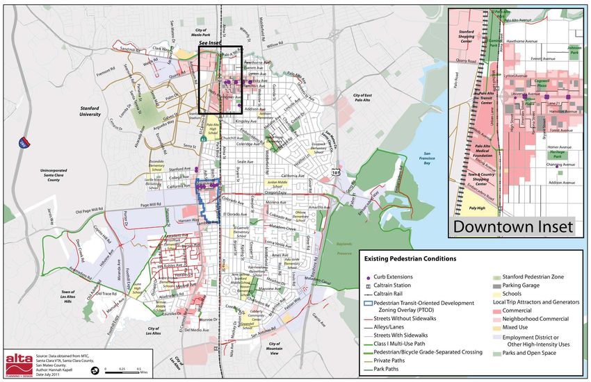
The City of Palo Alto is a community with an estimated 64,500 residents (a 10% increase from 2000) located
between the open space preserves of the foothills and the tidal flats of San Francisco Bay. With an established
grid network of streets, vibrant business districts, a well-known park and trail system, and direct proximity
to Stanford University, much of Palo Alto is highly walkable. Flat terrain, tree-lined streets, and a temperate
climate also make Palo Alto a relatively easy place to bicycle. Two U.S. Interstate highways, a major rail
corridor, and one county expressway divide the city into several distinct communities with unique circulation
patterns.

The 2011 City of Palo Alto Bicycle + Pedestrian Transportation Plan (BPTP 2011) exists to guide public and private
investments in the city’s non-motorized transportation facilities and related programs, and to comply with
state eligibility requirements for Bicycle Transportation Account (BTA) funds. Within Santa Clara County, a
current BPTP is required in order to include projects within the Valley Transportation Authority (VTA)
Bicycle Expenditure Plan (BEP). The BPTP 2011 expands the 2003 Bicycle Transportation Plan to include coverage
of pedestrian issues, priorities, and design standards in addition to revising the proposed bikeway network
and design guidelines. Many of its components will also be included in the upcoming update to the City’s
Comprehensive Plan Transportation Element. From planning citywide networks to reviewing private
development proposals, the BPTP 2011 is meant to provide the vision, design toolkit, and specific
recommendations that will increase walking and biking in Palo Alto now and for years to come.

Below is a summary description of key planning efforts that directly influenced the development of the Bicycle
+ Pedestrian Transportation Plan. Appendix D of this Plan provides a more detailed review of existing plans and
policies.

At the state level, the passage in 2008 of Assembly Bill 32 and Senate Bill 375 – which together require a
statewide reduction of greenhouse gas emissions (GHG) to 1990 levels by 2025 among other mandates – has
propelled a number of regional planning initiatives that positively influence the BPTP 2011 and transportation
investments in Palo Alto. Within the regional framework established by the Association of Bay Area
Governments (ABAG) and the Metropolitan Transportation Commission (MTC), new programs and funding
sources are being developed that emphasize:
    x   “Complete” streets and the routine accommodation of cyclists and pedestrians in all projects.
        The California Complete Streets Act (AB 1358) requires all cities and counties, when they update their
        general plan circulation element, to identify how the city or county will provide for routine
accommodation of all roadway users including motorists, pedestrians, bicyclists, people with
        disabilities, seniors and users of public transportation – or to design ‘complete streets’ for all users.
    x   Climate action and reduction targets for greenhouse gas (GHG) emissions. MTC ‘s Transportation
        2035 Plan, the regional blueprint for transportation investment, includes a new $400 million Climate
        Action Campaign to reduce the region’s carbon footprint and complement established programs such
        as the Transportation for Livable Communities (TLC) and Regional Bicycle Program. The Climate
        Action Campaign includes funding for the Safe Routes to School and Safe Routes to Transit
        programs, and an $80 million Climate Initiatives Program that aims to test new strategies to reduce
        transportation-related emissions and vehicle miles traveled, such as a regional Bike Share Program
        organized around the Caltrain corridor that will include Palo Alto.
    x   The integration of land use and transportation planning to support livable, walkable, transit-
        oriented communities. More than ever, the viability of transportation planning is viewed in the
        context of its ability to shape and serve compact neighborhoods and mixed-use centers that help
        reduce average trip lengths, promote transit patronage, and encourage more active and healthy
        lifestyles
While these ideas are not new, their widespread adoption in recent years has brought meaningful progress
toward policy goals and targets with “teeth” and improved practices and funding opportunities for non-
motorized facility planning and design.

The Valley Transportation Plan (VTP) 2035 is Santa Clara County’s long-range planning document that feeds
into (and is consistent with) MTC’s Regional Transportation Plan, and incorporates specific needs identified
by the Valley Transportation Authority (VTA) and individual municipalities, including Palo Alto. The VTP
2035 considers all travel modes and addresses the linkages between transportation and land use planning, air
quality, and community livability. The Bicycle Expenditure Plan (BEP) of the VTP 2035 identifies a need for
bicycle capital projects totaling over $330 million, which include major Cross-County Bicycle Corridors
(CCBC), 24 On-Street Bicycle Routes, 17 Trail Networks, and over 100 Across Barrier Connections (ABC)
project concepts. The large-scale projects identified for Palo Alto in the VTP 2035 include the Adobe
Creek/Highway 101 Bicycle/Pedestrian Grade Separation project.

The City of Palo Alto Comprehensive Plan establishes clear support and priority for investing in non-motorized
transportation, improving access to transit, and reducing dependence on single-occupant vehicles to improve
the overall efficiency of the transportation system. The existing Comprehensive Plan, which is under revision
at the time of this planning effort, includes a vision statement and variety of goals that strongly influence and
reflect the values of the Bicycle and Pedestrian Transportation Plan. These include the following:
    x   Goal T-1: Less Reliance on Single-Occupant Vehicles
    x   Goal T-3: Facilities, Services, and Programs that Encourage and Promote Walking and Bicycling
    x   Goal T-6: A High Level of Safety for Motorists, Pedestrians, and Bicyclists on Palo Alto Streets
    x   Goal C-5: Equal Access to Educational, Recreational, and Cultural Services for All Residents
To harmonize with the Comprehensive Plan Transportation Element revision process, the BPTP 2011 proposes no new goal statements. Instead, this Plan presents a manageable set of objectives, key strategies, and benchmarks to guide plan implementation, along with recommended policies and programs for consideration within the Comprehensive Plan update process. The 2007 Palo Alto Climate Protection Plan (CPP) targets a 15 percent reduction in greenhouse gas emissions from 2005 levels by 2020 to comply with state reduction goals. Recognizing that automobile travel comprises 36 percent of total GHG emissions within Palo Alto, the CPP recommends providing a transportation demand management (TDM) coordinator position. Medium-term recommendations are to expand pedestrian-friendly zoning regulations and to complete transit projects on El Camino Real and the Palo Alto Intermodal Transit Center. Unfortunately, the CPP does not make extensive reference to the 2003 Bicycle Transportation Plan or efforts to accelerate its implementation – despite the fact that 83 percent of auto-related emissions are from discretionary, non-commute trips within Palo Alto (i.e., a significant percentage of which could be converted to zero-emission walking or biking trips). The 2011 Bicycle + Pedestrian Transportation Plan incorporates recommendations and, consistent with the CPP, and targets increased funding for bicycle and pedestrian projects and programs. The 2003 Bicycle Transportation Plan identifies existing bikeways; analyzes bicycle and pedestrian accident data; and recommends new bikeways, bicycle education and safety programs, and bicycle support facilities (including bike parking). The recommended bikeways network features bicycle boulevards, bike lanes on arterial streets, new bicycle/pedestrian grade separations, and spot improvements at key intersections. The 2003 Plan also details recommended best practices for bicycle education and outreach programs, bicycle facilities design and maintenance, and enforcement. Notwithstanding the inclusion of a new pedestrian component, the BPTP 2011 is in many respects an update of the 2003 Plan, which remains a valuable reference document for bicycle planning in Palo Alto. The BPTP 2011 updates the 2003 Bicycle Transportation Plan to include a new policy framework, innovative facility design strategies (such as green bike lanes, cycletracks, and intersection through-markings), and a revised bikeway network and priority project list among other changes. The BPTP 2011 maintains many of the 2003 Plan recommendations and provides additional project recommendations including Pedestrian facilities to help better integrate facilities such as parks and community trails. The BPTP 2011 Plan provides project recommendations by categories to help prioritize implementation over the next five years, by which time another BPTP planning efforts should occur.
The 2011 Bicycle + Pedestrian Transportation Plan development
process included a public open house and an online survey to
solicit input from the general public. Members of the public
attended an initial open house in March 2011 to review early
project ideas and focus areas Over 500 completed the online
survey, providing significant feedback on a number of bicycle
and pedestrian topics. A second open house outreach effort is
scheduled for July 2011 during the public comment period of the
Draft BPTP 2011.
The BPTP was developed in coordination with the Palo Alto
Bicycle Advisory Committee (PABAC), an 11-member citizen
advisory committee with particular knowledge of and interest in
non-motorized issues and conditions. In addition to PABAC,
two meetings each were held with the City/School Traffic Safety Committee and the Planning &
Transportation Commission. The City/School Traffic Safety Committee is a partnership forum between
community leaders at each of the public schools in the City, Palo Alto Unified School District (PAUSD)
administrators, and City staff. The Planning & Transportation Commission is an appointed commission that
provides policy recommendations to the City Council on development and transportation projects. A bicycle
tour of one of the City’s new planned bicycle boulevards was held before a Study Session of the City Council
halfway through the BPTP 2011 development process. Presentation materials from these meetings were made
available online via the city planning department’s bicycle and pedestrian webpage.
A more detailed summary of the online survey results and public comments can be found in Appendix C.
The remainder of the City of Palo Alto Bicycle + Pedestrian Transportation Plan is organized as follows:
This chapter provides details on the policy and strategic frameworks that guided the Plan development
and will ultimately be used to measure progress and build accountability into the Plan implementation.
This chapter documents the main existing walking and biking infrastructure in Palo Alto, including the
existing bikeway network, as well as the programs that help deliver and promote both infrastructure and
non-infrastructure non-motorized solutions. The programs are organized according to the five “E”s of
transportation planning – Engineering, Education, Encouragement, Enforcement, and Evaluation.
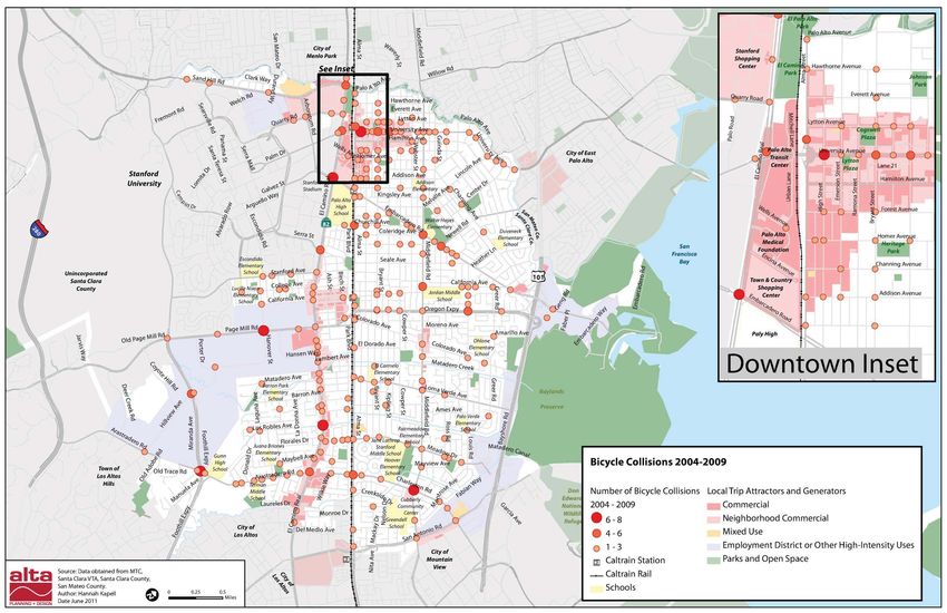
This Chapter summarizes available travel data, distinguishes types of trips made by walking and biking,
and assesses the collision history for both pedestrian and bicycles for the period 2004 to 2009.This chapter synthesizes existing conditions, recommends focus areas, and identifies new programs and strategies to support specific infrastructure investments. This chapter introduces the Recommended Bikeway Network and Priority Pedestrian Areas, and describes existing and recommended conditions by sub-area. This chapter proposes a prioritization strategy and list of projects to consider for implementation and further analysis in the coming years. This chapter also documents planning level costs associated with each project and/or facility type along with a short list of potential funding sources and a note on the Plan’s environmental analysis. This section provides facility design guidelines as a reference toolkit for implementing key projects and facilities. This section summarizes or identifies the location of information and analysis required for Bicycle Transportation Account Compliance. This section documents public comments received during the plan development process and the results of the Plan’s online survey This section is a detailed reference summary of federal, state, regional, county, and local plans and programs that influence the 2011 Bicycle + Pedestrian Transportation Plan, including a table summary of all relevant Comprehensive Plan Goals, Policies, and Programs. This section provides a table of priority projects, an expanded discussion summary, planning level cost estimates, and their relative ranking within eight bicycle and pedestrian categories; as well as descriptions and cost estimates for all proposed bikeways. This section is a more detailed list of potential funding sources, including a summary of the City of Palo Alto’s six-year Capital Improvement Project (CIP) plan.
As stated in Chapter 1, the BPTP 2011 builds on existing goal statements from the City of Palo Alto Comprehensive
Plan in an effort to provide direction and accountability for Plan implementation. The first section of this
chapter outlines five objectives, each with key strategies and benchmarks. This second section introduces a
set of guiding principles that were developed specifically for this Plan, which provide a strategic and
interdisciplinary ‘filter’ to assist project development and decision-making.

The following Plan objectives support the goals identified in the City of Palo Alto Comprehensive Plan and reflect
specific targets and mandates from the Climate Action Plan, the state Complete Streets Act and regional
Sustainable Communities Initiative, and the December 2009 Palo Alto City Council Colleagues Memorandum
outlining desired elements of the 2011 Bicycle + Pedestrian Transportation Plan.

Work commute trips are the primary source of peak period congestion on local streets, and significant
conversions to bicycling (and walking) can reduce the number of cars on streets and increase the efficiency of
the existing roadway network. A number of factors directly influenced by transportation investments and
policies contribute to bicycle commute demand.

    x   Target employment districts with enhanced bicycle facilities and improved connections to and across
        major barriers
    x   Improve planning coordination and physical connectivity with adjacent communities
    x   Support and expand large employer TDM programs (including the City’s and Stanford’s) and
        enforce/update existing transportation management plans
    x   Implement and promote the Caltrain-focused bicycle share program and seek to expand elsewhere
        within the city
    x   Continue to promote Bike to Work Day and related activities

    x   U.S. Census / American Community Survey
    x   Large employer TDM and/or business district surveys including Stanford University’s General Use
        Permit cordon counts; TMP reports
    x   Construction of new Across Barrier Connections
The City has a goal to reduce all GHG emissions by 15% from 2005 levels in order to comply with statewide
climate action targets. Since non-commute discretionary travel is the single largest source of GHG emissions
within Palo Alto (see Error! Reference source not found.), and since the majority of trips tend to be only a
ew miles in length, conversion to non-polluting walking and biking trips is both a high priority and viable
objective. This approach also helps directly link climate action priorities with future non-motorized funding
levels.
x Focus investments across and along the Residential Arterial and School Commute Corridor Network
to support the Safe Routes to Schools program
x Develop and implement a new Safe Routes to School Program with bicycle and pedestrian school
route maps and expanded education programs
x Expand education and encouragement efforts to include more regularly scheduled street closure
events, family bicycle outings, traffic skills training, “teaching rides,” pedestrian safety campaigns, and
innovative bicycle facility instruction
x Improve non-motorized access to shopping centers, mixed use districts, and grocery stores/farmer’s
markets; provide sufficient bicycle parking and ‘placemaking’ opportunities in these locations
x Remove and/or upgrade substandard bike lanes and trail crossing barriers to improve safety and
convenience
x Safe Routes to School (SR2S) project development; SR2S hand tallies and parent surveys
x Pedestrian and bicycle counts
x Total annual Vehicle Miles Travelled (VMT) and GHG emissions
Planners and public health officials are consistently making the connection between better bicycling and
walking facilities, increased physical activity and mental well-being, and reduced rates of obesity, diabetes,
asthma, and other chronic diseases. In a separate but related trend to encourage non-motorized travel, many
cities are more actively managing their streets to include vehicular closures and special events outside of peak
travel periods. Specific to Palo Alto, many school and open space areas are critical links in the (proposed)bicycle boulevard and off-street trail networks, which provides an opportunity to develop a more coherent
recreational system for the growing youth and family populations.
x Prioritize enhancements to the Bay to Ridge Trail corridor; consider designating spur trails and
secondary alignments that provide connecting off-street pathways
x Develop, sign, and promote a bicycle boulevard network that incorporates important linkages
through and across school and park properties
x Encourage and support the development of neighborhood greenways, linear park features, and “Safe
Routes to Parks” projects that utilize the designated bikeway network
x Promote regularly scheduled street closure events as a strategy to encourage physical activity and
provide unique non-motorized travel opportunities
x Develop a maintenance program to repave existing trails
x Expand trail networks along creeks through partnership projects with regional agencies including
the Santa Clara Valley Water District (SCVWD)
x Miles of bicycle boulevards, enhanced bikeways, and trails developed
x Numbers of pedestrians and bicyclists on key facilities, as determined by counts
x Number of annual street closure events
Pedestrians - especially children, seniors, and the disabled - represent the most vulnerable users of the street
network and have a civil right to be able to travel safely and conveniently in the public realm. While certain
streets may be more important for regional mobility, all streets should accommodate non-motorized travel
unless specifically prohibited under state law.
x Accelerate the installation of accessible curb ramps and pedestrian countdown signals in commercial
centers, school zones, around senior centers and hospitals, and near key transit stops or stations
x Develop a Complete Streets checklist and formal approval process for all infrastructure projects,
including major roadway maintenance, in order to identify and maximize pedestrian and bicycle
improvement opportunities.
x Improve top collision locations and other high volume pedestrian arterial crossings.x Study the feasibility of ‘road diets’ on all streets with two or more travel lanes per direction to allow
for dedicated bikeways and safer, more frequent pedestrian crossings
x Target transit facilities to enhance mobility and access, especially for seniors and youth
x Develop a focused signage program accessible to seniors
x Annual installation of ADA curb ramps and accessible pedestrian signals
x Top pedestrian and bicycle collision locations improved or studied
x Annual pedestrian and bicycle collisions
x Projects with Complete Street checklists completed and approved
The clarion call for climate action and sustainability necessitates a move toward integrated project scopes and
goals, as opposed to stand-alone single-purpose projects. To be sustainable (and increasingly to be
competitive for outside grant opportunities), projects must achieve progress in multiple disciplines so that the
whole is greater than the sum of its parts. Such an approach can leverage efficiencies of scale, while reducing
construction impacts on neighborhoods and businesses.
x Regularly coordinate scopes and timelines of roadway maintenance, utility, and private development
activities to identify potential collaboration opportunities on the bikeway network and within
priority pedestrian areas
x Evaluate and develop transportation programs and facilities using the Five “I”s – Integration,
Inclusion, Innovation, Investment, and Institutional Partnerships – in addition to the traditional five
‘E’s framework (described in Chapter 3)
x Development of “Plan Line Studies” along residential and commute arterial streets to guide design of
local projects and identify community improvements
x Total grant funding awarded for bicycle and pedestrian-related transportation improvements
x Projects completed involving multiple agency or departmental funding sponsors
x Pedestrian and bicycle facilities implemented by private developmentThe Five “I”s is a customized set of guiding principles developed for the 2011 Bicycle + Pedestrian Transportation
Plan that helps strategically organize and focus transportation investments. Used to guide Plan development
and prioritization, a brief description of the Five “I’s” is presented below:
In addition to integrating pedestrian needs into the new transportation plan, this principle seeks the
integration of non-motorized accommodation into the regular decision-making processes of Palo Alto. It
also serves to align the plan with sustainability and climate action goals that increasingly call for shared
accountability and the avoidance of planning “silos” and single-purpose projects.
Acknowledging that the “strong and fearless” cyclists (i.e. adult commuter and recreationists) are
reasonably well-served by the existing bicycle network, the principle of inclusion strives for actions and
projects that meet the needs of more novice cyclists and reach a broad spectrum of non-motorized users in
Palo Alto. This principle also speaks to the concept of “access for all” for those with mobility impairments
or without access to motor vehicles
This principle highlights the role of Palo Alto (and Stanford) as a national leader in good ideas with a
historic commitment to experimentation (i.e. learning by doing). These notions are crucial to advancing
non-motorized design, where lengthy approval processes and other constraints can unnecessarily hold up
the most trivial of advances.
Build and utilize relationships with Stanford University, adjacent jurisdictions, major employers (such as
Lorac Business Systems Inc, Hewlett-Packard, AOL, and Facebook), and the Palo Alto Unified School
District to realize the plan’s success. Explore private/public partnerships and ways to extend the sense of
accountability beyond and across public agencies.
Attract, leverage, and commit to a fair share of resources for bicycle and pedestrian facilities and
programs. Seek to use these resources efficiently, but understand that you typically get what you pay for.
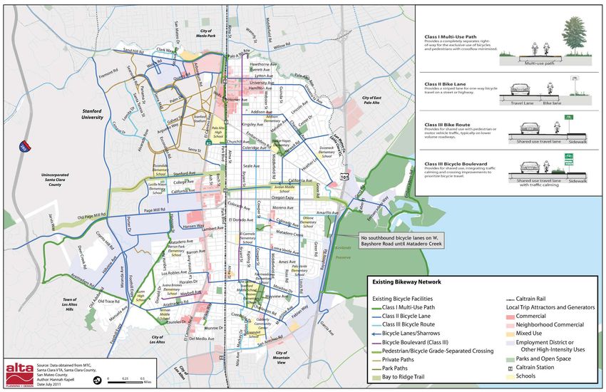
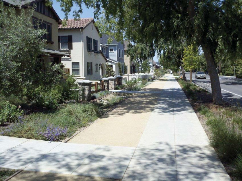
As a Plan strategy, maximize the competitiveness of the City of Palo Alto to receive outside grant funding.The City of Palo Alto, in combination with the Stanford University campus and related properties, includes a wide range of pedestrian conditions. Below are short descriptions of existing facility types and select assets, some of which are depicted in Map 1. Pedestrian activity is most often accommodated with dedicated facilities separated from motor vehicle traffic, i.e. sidewalks. The majority of Palo Alto contains a connected network of sidewalks, the main exceptions being southwest Palo Alto and other select corridors where residents do not desire them or where feasibility is extremely limited. In addition to sidewalks, 15 miles of Class I facilities and park paths offer additional separation from traffic.
Distinct from sidewalks and shared use paths, many unpaved trails exist both in the regional open space areas
and within larger private developments and parcels. These facilities include an extensive trail network
opposite the Bol Park Path and VA Medical Center in the Stanford Research Park and behind a recent
development near Loma Verde Avenue and Matadero Creek. Both areas are shown on
Map 1 – Existing Pedestrian Conditions as private paths but are not distinguished from other paved
surfaces.

Courtyards and pedestrian alleys/pass-throughs interior to city
blocks also provide important dedicated space for pedestrian
refuge and activity. Several well-executed examples are located in
downtown, including the Ramona Plaza development and the
Scott Street connection to Heritage Park, while additional
pedestrian cut-throughs are located in the California Avenue
Business District. Plazas, parks, and other semi-private open
spaces (including school grounds) are also particularly important
for neighborhood connections and pedestrian activity in Palo
Alto.

Stanford University’s central campus restricts motorized vehicles (except in limited circumstances) to
maintain a pedestrian and bicycle-friendly network of street malls and paths. While several visions have been
proposed for a similar pedestrian mall/zone in or near downtown Palo Alto without success, it is worth noting
that temporary (and less controversial) dedications of pedestrian space are often made during parades, street
festivals, farmer’s markets, and other events.
The term ‘shared facilities’ primarily refers to facilities shared between pedestrians and bicycles. However, it is
worth briefly noting the existing conditions and needs of shared-use paths and barrier crossings (distinct
from sidewalks). As the name implies, shared-use paths are off-road facilities where the mixing of bicycle and
pedestrian traffic occurs, which at times may cause conflict where bicycle speeds and/or peak volumes are
high or where visibility is restricted. These potential conflict conditions are exacerbated where there is
insufficient width to meet Caltrans Class I path standards (see Figure 3-1 on page 3-10), such as in older parks
and barrier crossings, and on several Stanford perimeter paths. In these locations barrier devices and/or
signage may exist to force bicycles to dismount or take extra precautions.

Despite much of the city having a network of interconnected sidewalks, as noted there are a few significant
exceptions. The majority of streets in the Barron Park and Monroe Park neighborhoods have unimproved
roadway edges or valley gutters without sidewalks due to the preference for maintaining a distinct rural
character. Although in some instances a soft shoulder is available for pedestrian travel, most of these streets
lack sufficient width for continuous facilities of any kind outside the travel way. Sidewalks are also not a
preferred option for many residents concerned with maintaining neighborhood character, impacting creek
riparian areas, or spending significant public resources in low-volume residential areas. Additional streets
with significant sidewalk gaps on at least one side of the street include Alma Street (Caltrain side, which has
no pedestrian destinations), Oak Creek and Palo Alto Avenues (along San Francisquito Creek), Oregon
Expressway, San Antonio Road approaching Highway 101, and several streets within Stanford Research Park.
Most service alleys and publicly owned surface parking lots require pedestrians and vehicles to share the
travel way. Distinct from streets without sidewalks, these facilities are typically narrower (alleys), next to
commercial activity centers, and prone to safety concerns (sight distance issues, personal security) if not well
lit or if accompanied by blank facades. Although not typically thought of as pedestrian facilities, the
predominance of these features in both the Downtown and California Avenue Business Districts makes them
especially relevant to existing conditions and as future improvement opportunities.

Technically, intersection crossings are instances of shared space between motorists and vehicles. Temporary
separation is achieved only through careful signing, striping, and/or signalization along with state and local
laws that require motorists to yield for pedestrians. While inventory data was not available, specific locations
and frequencies of the most prevalent intersection devices and controls are discussed below.

In California, it is legal for pedestrians to cross where any
two streets intersect, except at unmarked, uncontrolled
locations between adjacent signalized crossings or where
crossing is expressly prohibited. In Palo Alto, the most
common unmarked crossings are at stop-controlled
intersections and between signals along arterial roadways
where traffic control and pedestrian markings are not
provided at minor street intersections.

Marked crossings (crosswalks) reinforce the location and
legitimacy of pedestrian crossing activity, and may be
provided at either signalized or unsignalized intersections.
Marking crosswalks at unsignalized locations with more
than one lane of traffic per direction is discouraged,
however, due to the “double threat” collision scenario
where a near-lane vehicle who driver yields to the
pedestrian hides a far-lane vehicle whose driver does not
see or anticipate the pedestrian Fortunately, few if any
such crossings exist in Palo Alto, although there are a
number of unsignalized crosswalks across two-lane
arterials where motorist compliance remains low (such as at the Churchill Avenue and Castilleja Avenue
intersection). The vast majority of crosswalks in Palo Alto include “standard” thermoplastic marking. Other,
less frequent striping patterns include “high visibility” zebra style crosswalks (an example of which is
currently at Alma Street and Hamilton Avenue) and ladder striping (Arastradero Road at Terman Middle
School and Gunn High School). In most new installations, an advance limit line (a solid stripe similar to those
used at stop signs, set back four feet from the crosswalk) has been provided to limit encroachment by stopped
vehicles.

A pedestrian countdown signals integrates a separate display for pedestrians that uses three phases: “walk”;
flashing “don’t walk” with a countdown; and “don’t walk.” Pedestrian signals provide additional information
regarding the amount of remaining time during the flashing “don’t walk” pedestrian interval; the countdown
displays may improve pedestrians’ judgment about whether is safe to cross the intersection. Legally,
pedestrians are prohibited from beginning to cross an intersection when the flashing “don’t walk” display is
initiated, although in practice this provision is consistently ignored or misunderstood by pedestrians and is
rarely enforced. As a peripheral benefit, pedestrian countdown signals can aid cyclists approaching an
intersection in deciding whether or not to speed up to clear an intersection before the light changes.
Pedestrian countdown signals have been installed at various signal locations in Palo Alto, with the majority in
commercial areas and business districts and on major arterials. A citywide deployment has yet to occur. In
addition, many downtown signals do not yet have any pedestrian signal at all.

Pedestrian Lead Phases (a.k.a. “Leading Pedestrian Interval”) and
pedestrian-only phases (“Pedestrian Scrambles”, or “All Pedestrian”) are
signal options that allow staggered or exclusive pedestrian and vehicle
movements to limit conflict at high volume intersections.
“Pedestrian Lead” phases begin the “walk” phase several seconds before
adjacent motor traffic receives a green light, enabling pedestrians to
occupy the crosswalk and improving their visibility to motorists
preparing to turn. Pedestrian lead intervals are deployed by the City of
Palo Alto at the intersection of Alma Street and Homer Street, adjacent
to the Homer Tunnel. Pedestrian Lead intervals should be considered
along high-vehicle volume corridors such as Embarcadero Road at San
Antonio Road and on Oregon Expressway-Page Mill Road with
coordination from the County of Santa Clara.
“All Pedestrian” phases prohibit all vehicle movements while
pedestrians cross, allowing for diagonal walking movements if desired.
Examples of both treatments currently exist within Palo Alto. The City
of Palo Alto implements All Pedestrian phases at select intersections
along Suggested Routes to School including Arastradero Road at
Donald Drive-Terman Road and Embarcadero Road at Middlefield
Road.
Future traffic signal timing should consider All Pedestrian phases on
University Avenue in the Downtown during peak hours as well as
streetscape projects to improve pedestrian crossings and maintain
vehicle progression.
Curb ramps are transitions between the sidewalk and legal roadway crossings that provide a smooth grade
change for pedestrians – in particular patrons with disabilities and other wheeled devices – and for bicyclists
dismounting or reaching a nearby parking spot. An intersection corner may contain one or two curb ramps
depending on the location of signal poles, traffic controller cabinets, drainage inlets, private property
boundaries, and other potential complicating factors. Generally speaking, curb ramps must be ‘readily
accessible to and usable by’ persons with disabilities in order to comply with the intent of the Americans with
Disability Act (ADA), although best practice guidelines provide specific designs for various curb ramps. Such
guidance includes FHWA’s Designing Sidewalks and Trails for Access, Part II (2001) as well as the pending Public
Rights-of-Way Accessibility Guidelines from the Access Board (Draft 2011).

Curb extensions, or “bulbouts,” are extensions of the
sidewalk into the adjacent parking lane(s) that help
reduce pedestrian crossing distances and vehicular
turning radii, which is a major factor in how fast
vehicles are able to turn. Curb extensions also
provide more sidewalk space for pedestrian queuing,
landscaping, seating, and other amenities. Except
along the University Avenue and California Avenue
corridors, very few curb extensions exist in Palo
Alto. Within these business district corridors, curb
extensions exist along all four corners of University
Avenue at Emerson Avenue, Bryant Street, Cowper
Street, and Waverly Street. A brick low-level wall
separates the single curb bulb at the southeast
corner of High Street. An additional four or five pairs
of curb extensions are located on California Avenue,
which will likely see that number increase with the
upcoming streetscape design project.

Center medians, pedestrian refuge islands enable
pedestrians to wait after crossing one direction of
motor traffic, which are especially valuable on long
crossings of busy thoroughfares such as El Camino
Real, Oregon Expressway, and San Antonio Road.
According to the Department of Public Works, the
City maintains 388 medians, islands, gateways, and
traffic diverters. Many of these medians are
landscaped for much of their length yet still allow
pedestrians to wait safely before finding a gap in
traffic or waiting for a green signal phase.
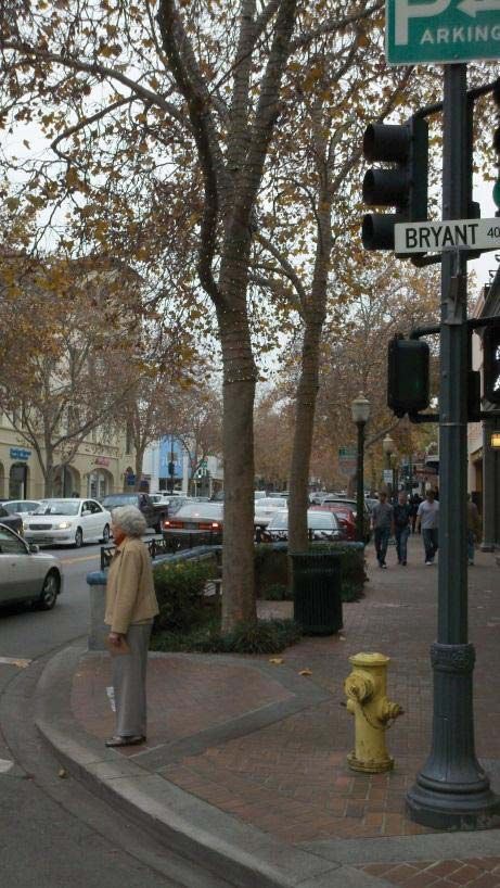
Commonly referred to as “pork chop” islands, these medians provide refuge from traffic yet are often less
pedestrian-friendly since they allow fast moving right turns. In older designs, narrow islands with curb ramps
force up-and-down movements that can be difficult for mobility-impaired persons. Newer designs provide at-
grade pedestrian cut-throughs that divide a large island.
The conversion of pork chop islands to widened sidewalks with bulb-out improvements help to better
integrate streets with land uses and are a common “Complete Streets” elements. The City of Palo Alto has an
active demonstration project at the intersection of El Camino Real and Stanford Avenue that includes the
conversion of two pork chop island facilities. Removal of pork chop islands can results in increased delay to
vehicle movements where heavy right turn movements exist and should be analyzed before deployment but
where implemented can help to greatly increase pedestrian safety through the increase of pedestrian dwelling
space at intersections.

Trees and landscaping, shelter from rain and wind, wayfinding, public art, pedestrian-scale lighting, seating,
newspaper-box corrals, sidewalk cafes, and many other interesting design features are all peripheral but
important components of the pedestrian realm in Palo Alto. These amenities are strongly encouraged in
Comprehensive Plan policies and programs, many of which are enforced and/or encouraged through design
guidelines in the Municipal Code.

In California, Caltrans designates three bikeway design types: Class I, II, and III Bikeways. Figure 3-1 shows
their general design standards. Palo Alto also has several enhanced Class III routes known as bicycle
boulevards (including Bryant Street, one of the nation’s first). These streets’ distinctive characteristics are
discussed separately below. In total, Palo Alto has nearly 65 miles of existing bikeways. Map 2 on page 3-19
illustrates the location of these bikeways.
Class I bikeways are also referred to as multi-use or shared-use paths. They are physically separated from a
roadway by either five feet of landscape or an impact barrier. Class I facilities are for exclusive use of non-
motorized transportation modes and must have a minimum paved width of eight feet as well as two-foot wide
graded shoulders. Palo Alto has 15.3 miles of Class I paths, as well as many additional paths that are physically
separated from traffic but whose narrow widths and/or surface treatments do not meet Class 1 requirements.
Many paths on the Stanford University campus also do not qualify as Class I facilities but are a significant
component of the greater Palo Alto area’s bicycle and pedestrian network. Although these “private paths” are
not included in the existing bikeway table, every effort has been made to include them on the Existing (and
Proposed) Bikeways Map.
Class II bikeways are striped lanes on roadways for one-way bicycle travel. Class II bike lanes on street
segments without parking must be at least four feet wide including any concrete gutter, with at least three
feet of asphalt. Bike lanes on streets with parallel parking must be at least five-feet wide, although many
communities are now adopting wider minimum width standards to reduce potential conflict with the “door
zone” and to encourage a wider range of cyclists.
The City of Palo Alto has 40 miles of Class II bike lanes, which exhibit a variety of widths and quality. Some
of the City’s bike lanes are time-restricted and revert to vehicle parking in the evenings and on weekends.
More detail on time-restricted, buffered, floating, and green painted bicycle lanes are included in Appendix A:
Design Guidelines.
Class III bikeways are signed bike routes where bicyclists share a travel lane with motorists. Typical
applications for Class III bike routes include roadways with bicycle demand but without adequate space for
Class II bike lanes, low-volume streets with slow travel speeds, especially those on which volume is low
enough that passing maneuvers can use the full street width, and as “gap fillers” for breaks in Class II lanes.
Palo Alto has eight miles of Class III bicycle routes, most of which are signed routes only and do not contain
shared lane marking (“sharrow”) markings. Application of sharrows is discussed in the proposed design
guidelines. High-demand Class III bikeway corridors under 2,000 vehicles per day (vpd) and over a half-mile
in length may be considered for designation as bicycle boulevards.
Bicycle boulevards are signed, shared roadways with especially low motor vehicle volume, such that motorists
passing bicyclists can use the full width of the roadway. Bicycle boulevards prioritize convenient and safe
bicycle travel through traffic calming strategies, wayfinding, and other measures. One key feature is that
unwarranted stop signs are “turned” - removed from the boulevard and placed on cross streets, improving
bicyclists’ average speed by minimizing unneeded stops. Palo Alto’s Bryant Street was the first bicycle
boulevard created in the United States.
The City generally prioritizes the following features when identifying or developing a potential bicycle
boulevard:
    x   Low traffic volumes
    x   Not attractive for vehicle through-traffic
    x   Free flow travel for bikes or reasonable ability to create right-of-way for bicycle traffic at
        intersections (i.e. removing or reversing unwarranted stop signs to prioritize bicycle travel)
    x   Traffic control at arterial crossings to assist crossing bicycle traffic
    x   Continuous streets with few jogs, and segments of a half-mile or longer
A 1982 study found that motor vehicle volumes remained consistently under 1,000 vpd along the Bryant Street corridor, despite reorientation of stop signs that also removed restrictions on through-movement for automobiles. In addition to turning stop signs, other common measures in Palo Alto to slow traffic and prioritize bicycle travel include traffic diverters, speed humps, traffic circles, and pedestrian/bicycle-only creek bridges. Palo Alto currently has 4.2 miles of bicycle boulevards, with another 2.5 miles planned for official designation in 2011 along the Castilleja-Park-Wilkie corridor. Both the Santa Clara County Valley Transportation Authority (VTA) and San Mateo County have designated bikeways of regional significance that traverse the City of Palo Alto. Additionally, local bikeways in the cities of Menlo Park, East Palo Alto, Mountain View, and Los Altos /Los Altos Hills connect at the city border. Table 3-5 lists bikeway connections from the City of Palo Alto to other Santa Clara County communities, ordered counterclockwise from the northern county line. Table 3-6 lists the connections between San Mateo County bikeways of countywide significance and the City of Palo Alto, ordered from southwest to northeast. The table includes connections to recreational routes such as Page Mill Road and commute routes such as Middlefield Road and Willow Place Path.
Bicyclists, like motorists, need a place to store their vehicle, whether a sidewalk rack to grab a coffee or a more
secure bicycle locker or cage for all-day parking near transit. Vandalism, theft, and convenience are all main
concerns for bicyclists, who typically expect parking close to their destinations. Where adjacent parking
facilities are not available, bicyclists tend to lock their bikes to street fixtures such as trees, and sign poles.
Use of street fixtures other than bicycle racks is problematic due to impacts to pedestrian facilities, instability
of the locked bicycle and deterioration of the streetscape and Complete Street concepts.
Bicycle parking is classified as short- or long-term, each
with distinct standards for type, capacity and placement:
    x   Short-term bike parking is usually a rack on the
        sidewalk or an on-street corral (bottom right)
        serving people bicycling for shopping, errands,
        eating, or recreation. Bicycle racks should support
        the bicycle at two or more points and should
        provide a moderate level of security by allowing the
        bike’s frame to be locked with a U-lock without
        lifting a wheel over the rack.
    x   Long-term bike parking encloses the bicycle and its accessories, and protects it from precipitation.
        This category is further divided into “individual-secure” facilities (bike lockers) and “shared-secure”
        facilities such as bike enclosures (“cages”) and bike stations. These facilities provide a high level of
        security but are often less convenient than racks for errands and shopping because it impractical to
        site them on public sidewalks.

Bicycle parking requirements for development ensures that bicyclists have somewhere secure and convenient
to park their bicycles at newly constructed buildings. The City’s current bicycle parking requirements do not
provide clear guidance to developers in terms of design and location and the rates of required parking do not
address the complexities of the street environment. Private development requirements for provision of bicycle
parking facilities are found in Chapter 18.83 of the Municipal Code, “Off-Street Parking and Loading
Regulations.” Typically, the number of parking spaces required is 10 to 25 percent of the automobile parking
requirement.

Wayfinding signs can help guide casual bicyclists and other users who are unfamiliar with city destinations
and can help them follow corridors involving multiple turns (common in Palo Alto). Although “Bike Route”
signs are located on most of the existing bicycle network (including all Class III bikeways and the “Ellen
Fletcher” Bryant Street Bicycle Boulevard), bicycle wayfinding signs are less comprehensive, located only at
strategic places in the bikeway network such as creek bridges and on routes connecting to the Bryant Street Bicycle Boulevard. Non-motorized travel within Palo Alto is constrained by several key linear barriers. In the north-south direction these include El Camino Real (State Route 82), Highway 101, and the Caltrain/Alma Street corridors. In the east-west direction these include four creek corridors (San Francisquito, Matadero, Barron, and Adobe). The provision and location of barrier crossings is a fundamental consideration for non-motorized travel, and there are currently long stretches where no such crossings exist. Below is a summary of existing pedestrian- and bicycle-only barrier crossings. Caltrain bisects Palo Alto in the north-south direction. While the train itself facilitates regional multimodal trips, the tracks and adjacent Alma Street corridor are a barrier to east-west bicycle and pedestrian circulation. The Homer Avenue Caltrain undercrossing for pedestrians and bicyclists opened in 2004. Its well- designed tunnel enables bicyclists to ride their bikes separate from pedestrians between the South of Forest Area (SOFA) neighborhood to the east and the Palo Alto Medical Foundation (PAMF) and Caltrain corridor path to the west side. The structure is 18 feet wide and 70 feet long with lighting and two skylights. The undercrossing roughly aligns with the Palo Alto Medical Foundation signal at El Camino Real, whose western leg has a path connecting to Stanford’s Lasuen Mall / path. Because of the potential importance of this axis as a Stanford non- motorized commute corridor, pedestrians and bicyclists would benefit from a more intuitive, signed connection between the undercrossing and signal. On the east side of the undercrossing, making Homer Avenue bidirectional for one or more blocks would create a direct bicycle connection to downtown and areas east of High Street. Two undercrossings are located in the transit center at Palo Alto Station, one along the University Avenue sidewalks under Alma Street and the tracks, the other underneath and across the Caltrain station platforms approximately one block to the north. Because both tunnels are relatively narrow for the peak pedestrian volume they serve, bicyclists are required to walk bicycles through them, although two-way riding is common on the University Avenue sidewalks. Many short- and long-term improvements have been previously suggested in this area, including a wider sidewalk tunnel on the north side of University Avenue, a new undercrossing facility near Everett Avenue (at the north end of the station complex), and a transformative
overhaul of the University Avenue interchanges with Alma, El Camino Real, Caltrain, and Palm Drive. The
combined usage of the transit center undercrossings is almost certainly the highest among all barrier crossings
in Palo Alto, although specific figures are not available.

The California Avenue undercrossing is located at Palo
Alto’s other Caltrain station and connects the California
Avenue business district and Evergreen Park/Ventura
neighborhoods with Old Palo Alto and Midtown. It is
heavily used due to its central location and the long
distances to the next closest surface crossings to the
north (Churchill Avenue, 0.6 miles) and south (Meadow
Drive, 1.3 miles). The current tunnel is narrow and its
ramp slopes do not meet ADA standards. Because of
unsafe speeding by bicyclists and skateboarders, two
uninviting but effective “maze” railings force cyclists to
walk their bikes. These mazes render the undercrossing
awkward for bicycles towing short cargo and child
trailers, and impassible to long bicycle cargo trailers.
Major connectivity and bicycle parking improvements are proposed and funded as part of the California
Avenue streetscape project, with additional access from the west provided by the Castilleja-Park-Wilkie
Bicycle Boulevard. Bicycle lanes and low traffic volumes on N California Avenue provide good bicycle access
from the east, while Jerry Bowden Park and the Oregon Expressway interchange at Alma Street provide mixed
conditions for pedestrians. Santa Clara County intends to study the replacement of the Alma Street/Oregon
Expressway bridge and should identify opportunities for improved connections from the southeast.

Embarcadero Road’s underpass of Alma Street and the
Caltrain line has wide sidewalks on both sides. Over 1,600
bicyclists used these sidewalks during a 12-hour period in
1978. In part because of the addition of the Homer Avenue
undercrossing, Embarcadero’s sidewalks now see only a
fraction of this activity, yet they remains an important
connection for many residents. The sidewalks in this
undercrossing are of a similar design quality to University
Avenue and provide direct access to the Town & Country
Shopping Center, Palo Alto High School (usually referred
to as “Paly High”), and the Caltrain Path. Connectivity on
the east side is made especially difficult by the confluence
of several skewed intersections, while high traffic
volumes and speeds limit the overall comfort of the
undercrossing, particular from the west.
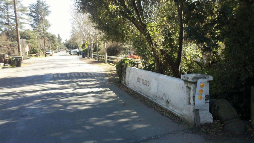
The undercrossing of Adobe Creek at Highway 101 is a popular access point for the Baylands and Shoreline
Park levee trails and other destinations (including Twisters Sports Center). It is generally only open for six
months (April 15 – October 15) because the path surface is only one foot above dry-season water level and is
regularly covered with mud and debris by even moderate storm flows. The undercrossing can be open for only
a few months during unusually wet years. The underpass is accessible from the west side of the highway via
Class II bicycle lanes on W. Bayshore Road and from the east via bike lanes on E. Bayshore Road as well as an
extensive network of Class I trails that extend to East Palo Alto and Mountain View. Two sets of mazes – one
at the E. Bayshore access point and one on the poorly-lit curve under the highway – create low-speed points
intended to minimize conflicts between pedestrians and bicycles, but which seriously deter bicycle trailers
and persons with mobility assistance devices (e.g. wheelchairs). An estimated 40,000 bicyclists and 3,000
pedestrians use the underpass during each of its half-year open periods.

The pedestrian/bicycle overpass south of Embarcadero
Road near Oregon Expressway spans over 1,000 feet
between St. Francis Drive/Oregon Avenue and E.
Bayshore Road. Part of the designated Bay to Ridge
Trail, it is the only existing year-round non-motorized
crossing of Highway 101 in Palo Alto. The bridge is
narrower than current Class I standards and
technically requires bicycles to be walked. The east and
west approaches are both located in relatively isolated
locations and are in need of comprehensive upgrades to
improve accessibility, visibility, and wayfinding. A
recent count effort identified 49 bicycles and 12
pedestrians using the overpass during a weekday
evening peak period, which equates to nearly 100,000
estimated annual users according to a non-motorized
travel demand model (Alta’s Seamless Travel Demand
Model) developed for and used by Caltrans.

Six pedestrian- and bicycle-only bridges help connect important bikeways and pathways within Palo Alto.
Three are located along San Francisquito Creek – two at Palo Alto Avenue in Downtown North and one west
of El Camino at Clark Way/Durand Way, connecting to San Mateo Drive in Menlo Park. One bridge each
across Matadero and Adobe Creeks provide through bicycle and pedestrian connectivity without through-
automobile connectivity on the unofficial southern end of the Bryant Street Bicycle Boulevard. A second
bridge across Adobe Creek connects Monroe Park to Wilkie Way and the soon-to-be upgraded Castilleja-
Park-Wilkie Bicycle Boulevard. These bridges are identified on both the existing and future bikeway maps.
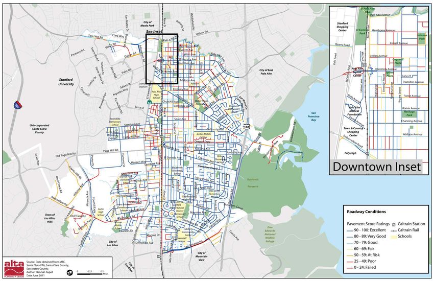
To shift people to bicycling and walking from other modes, a community must consider not just infrastructure
improvements but also programs that support and encourage the choice to bike or walk. Many programs can
be categorized according to the “Five E’s”: Engineering, Education, Encouragement, Enforcement, and
Evaluation. The Five E’s are commonly used to structure Safe Routes to Schools programs and are considered
in the League of American Bicyclists’ Bicycle Friendly City application.

The City, in collaboration with the Palo Alto Unified School District and parent volunteers from the Palo Alto
Council of PTAs, began to coordinate efforts to reduce congestion and improve safety for students on their
way to and from school in 1994, using the traditional three E’s of engineering, education and enforcement.
Since 2000, when this partnership was expanded to include the 4th ‘E’ of encouraging alternatives to single
family driving to school, the City has seen a significant and on-going increase in biking and walking to school
as a direct result of these efforts. Several schools now depend on maintaining high levels of non-motorized
student commuting to keep their school zones from being overwhelmed by motor vehicle drop-off and pickup
activity.
In Fall 2010, the Valley Transportation Authority (VTA) awarded Palo Alto a “Vehicle Emissions Reduction
Based at Schools” (VERBS) grant. With this grant the City will increase the reach and content of its existing
education, encouragement and evaluation programs by extending their efforts to four “Choice Program”
schools and conduct direct outreach to Spanish and Chinese language families. Because the grant was funded
through MTC’s Climate Action Initiative, the 5th ‘E’ of evaluation will also include assessment of greenhouse
gas emissions reductions. Each of the following ‘E’ categories offers additional highlights of the Safe Routes to
School Program.

Engineering strategies include City programs to provide high-quality infrastructure to support bicycling and
walking. A majority of the BPTP includes discussion and recommendations pertaining to engineering
strategies, although below is a select list of existing programs.

Many bicyclists consider pavement condition when selecting travel route, which includes the quality of
pavement markings, signal detection systems, and adjacent curb ramps. Map 3 depicts the latest pavement
quality information for Palo Alto streets, based on the Pavement Management System. Note that the map does
not reflect recent improvements to Arastradero Road between El Camino Real and Gunn High School.
The pavement condition index report is updated every four years to refine the priority of future street
resurfacing and surface treatment programs. Each winter, a list of streets for the annual resurfacing program
is prepared with input from the Transportation Manager and Palo Alto Bicycle Advisory Committee (PABAC)
to ensure that bicycle priority streets are included. Continued coordination with the resurfacing program
provides a unique opportunity to implement recommendations of the BPTP 2011 and allows for efficient
coordination of funding sources.
You can also read