CityOS connection - Decode
←
→
Page content transcription
If your browser does not render page correctly, please read the page content below
CityOS connection

H2020-ICT-2016-1     DECODE   D5.2 CityOS connection
                       0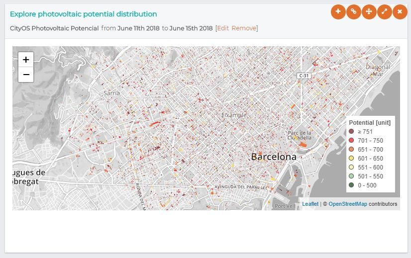
Project no. 732546

                                          DECODE
DEcentralised Citizens Owned Data Ecosystem
D5.2 CityOS connection
Version Number: V1.0
Lead beneficiary: IMI BCN
Due Date: June 30th
Author(s): Oleguer Sagarra, Javier Rodríguez, Francesca Bria (IMI BCN), Francisco
Sacramento Gutierres, Mirko Marras, David Laniado (Eurecat)
Editors and reviewers: Guy Samuel, Jordi Coscolla (TW)

Dissemination level:
PU    Public                                                                                                   X

PP    Restricted to other programme participants (including the Commission Services)

RE    Restricted to a group specified by the consortium (including the Commission
      Services)

CO Confidential, only for members of the consortium (including the Commission
      Services)

Approved by: Francesca Bria (Chief Technology and Digital Innovation Officer,
Barcelona City Hall)
Date: 02/07/2018

This report is currently awaiting approval from the EC and cannot be not considered to be a final version.

H2020-ICT-2016-1                                        DECODE                              D5.2 CityOS connection
                                                             1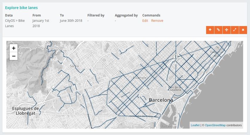
Table of Contents
Abbreviations                                                                    3
1 Introduction                                                                   4
  1.1 Scope of BCNNow & relation to previous deliverables                        5
2 CityOS                                                                         7
  2.1 What it is                                                                 8
  2.2 Data provision                                                             9
  2.3 Infrastructure                                                             9
  2.4 Connection status                                                        11
3 Technical connection details                                                 12
  3.1 CityOS Data Description                                                  12
  3.2 Connection with CityOS API                                               14
  3.3 CityOS Connection to BarcelonaNow                                        19
Conclusions                                                                    23
References                                                                     24

H2020-ICT-2016-1                       DECODE               D5.2 CityOS connection
                                          2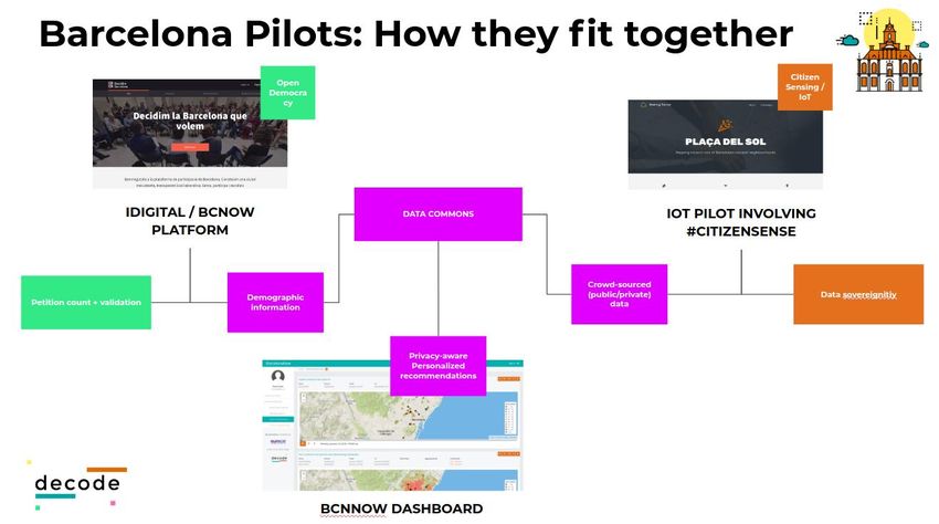
Abbreviations
BCN           Barcelona
CityOS        Operating System of the City
IMI           Municipal Institute of Information Technology / Institut Municipal d’Informatica
WP            Work Package
BCNNow        Barcelona Now (the dashboard system described in detail in deliverable D5.3)
ASIA          Application of Integrated Attention Systems / Aplicatiu de Sistemes Integrats
              d’Atenció
IRIS          Incidents, Claims and Suggestions / Incidencies, Reclamacions i Suggeriments
SME           Small and medium-sized enterprise
API           Application Programming Interface
WFS           Web Feature Service
IMI           Municipal Institute of Information Technology / Institut Municipal d’Informàtica
KVP           Keyword Value Pair
OAUTH2        Open Authorization
JSON          JavaScript Object Notation
OGC           Open Geospatial Consortium
CRC           Coordinate Reference System
WGS           World Geodetic System

H2020-ICT-2016-1                             DECODE                      D5.2 CityOS connection
                                                3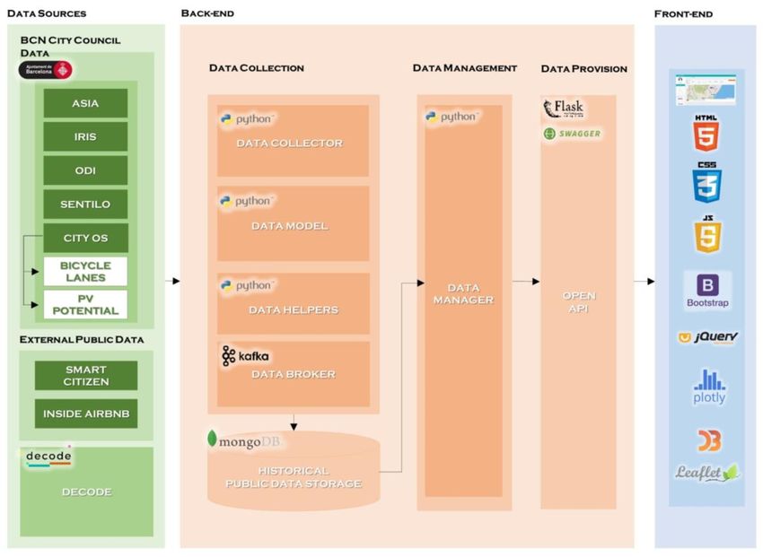
1 Introduction
DECODE aims to fulfill multiple goals related to data sovereignty, which means giving
back control and onwership over their data to citizens. To achieve such a goal, many
disciplines and actors must come together, including citizens, SME’s, private larger
companies as well as public institutions. Public institutions are particularly important as its
engagement with DECODE can lead to establish a sustainable environment where to
grow a consistent privacy-preserving and rights respectin públic data infrastructure
and a community beyond the duration of the project. The participation of two city
councils in the project ensures that the assets generated in form of cryptography,
privacy-aware tecnologies, data commons licencing and societal models of data
management can be field tested in real scenarios, but for this efficient, hybrid, forms of
integration between citizen-owned infrastructures and public administrations must be
developed.

Such an infrastructure is BCNNow, which aims at being the meeting point where data
generated through the DECODE pilots meet citizens and public deliberation. BCNNow
will be a tool used by DECODE users to generate visualizations, obtain personalized
views and information based on both publicly available data, privately owned one and
crowd-sourced one. BCNNow adds a visualization and interaction layer to the different
components of the DECODE ecosystem1.

In Barcelona this infrastructure is developed starting from a new approach to data
management initiated by the Barcelona City Council and led by the CTIO Francesca
Bria. Barcelona has issued a new Data Directive that mandates data sovereignty,
privacy and security by design and data ethics, as a set of ethical standards for the
digital transformation. This means that these standards are integrated as clauses into
government’s contracts and procurement processes. This positions Barcelona as
pioneer of a new data commons approach here described. The City also defines data
as a públic infrastructure, a new meta-utility like wàter, electrivity, roads, and the air we
breath. Data should be controlled by citizens and accessible with appropriate privacy-
protection, data entitlements, and ethical standards to all citizens, local entrepreneurs,
and other organisations that are able to build future data-driven services that deliver
públic value.

In this Deliverable, we describe how this vision is realised within the DECODE project, by
integrating DECODE with the core data architecture of the City of Barcelona. We detail
a new enhancement added to the BCNNow dashboard, following the overall
infrastructure and design laid out on D5.1 and D5.3. BCNNow is now connected to the
Data Lake of the city council of Barcelona, named CityOS. Since the Data Lake is not

1   See “D1.4 First version of DECODE Architecture|DECODE “ 31 Oct, 2017.
H2020-ICT-2016-1                             DECODE                     D5.2 CityOS connection
                                                 4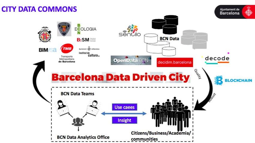
yet in production phase, the data currently being shared via the platform is not
exhaustive, but the technical foundations are there to allow for a generalization of the
types of data being shared once more datasets are added to the city council platform.

The document is organized as follows: The first section section places in context the
current deliverable with the whole project. Section two provides a high level description
of the architecture of the CityOS and its relation to the BCNNow infrastructure. Section
three gives technical details on the connection between both infrastructures and a
final section finalises the document with some concluding remarks.

1.1 Scope of BCNNow & relation to previous
deliverables
The general scope of BCNNow and its relation to the BCN Pilots, project tasks and
deliverables is highly detailed in the earlier deliverable D5.1. In this document, suffice it
to say that as the shape of the BCN pilots becomes more defined, thanks to the
iterating agile procedure used in this project (see deliverable D1.1 for more details), so
does the key role of BCNNow as an interface for data consumption of pilot users. This is
schematically shown in the diagram below, where we can see that BCNNow must fulfill
a role in being the platform where DECODE Pilot case users in Barcelona will be able to
visualize their data rights as well as collectively deliberate over them in order to shape
and define a City Data Commons that will be described in the future deliverable D2.5
“Digital democratisation: a heuristic framework”, and will be also the main area of study
for WP5 and WP2.

                   Figure 1: Schema of relations between BCN Pilots and BCN Now.

H2020-ICT-2016-1                             DECODE                       D5.2 CityOS connection
                                                 5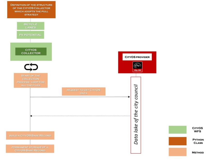
It is important to note that the learnings of the interaction with public officials to make
this connection possible is constituting a valuable output of research. This output
combines with the current work being developed to allow the BCN City Council to host
different variations of DECODE Nodes developed in the framework of WP4 and more
concretely in the deliverable D4.8 “Hardware prototype and reference platform
running the DECODE OS” and in the next deliverable D4.6 “Deployment and integration
for the DECODE OS and HUB platform”. The vision behind this work is to make DECODE a
critical component of teh BCN City Data infrastructure, that will allow the city to move
towards its vision of developing a decentralised, privacy-enhancing and rights preservin
Data Commons.

DECODE – with all its components- will allow citizens to be in control of the their own
data, and to decide what data they want to share with the city hall as a “common
good” that can improve públic services, while at the same time maintaining its
ownership and setting the terms of use through the DECODE entitlement and data
commons licencing framework. In this way, BCN will be able to implement a mixed
públic-commons approach to data management that will allow a better ridistribution
of wealth and value generated from the city data. See below the City Hall frameworks
that includes this implementation of DECODE:

                         Figure 2: Barcelona Data Commons Framework

H2020-ICT-2016-1                          DECODE                      D5.2 CityOS connection
                                             6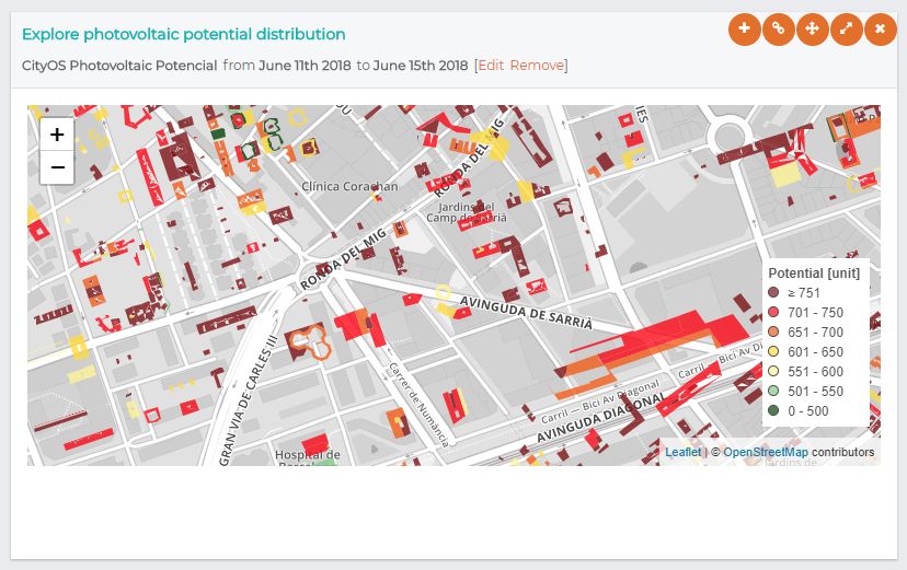
2 CityOS
In short, and following the schema of D5.1, we complement the information given there
with the details concerning the CityOS infrastructure.

Technology is not neutral, nor the infrastructures that allow for it to be put to service. The
city of Barcelona, in line with its technological sovereignty strategy, wants to foster
citizen’s control of data and the common good. Its strategy in the recent years has
been aimed at developing a city model based on new technologies, renewable
energies, efficient and sustainable transport and also reliable data management tools.
This last point made possible the launch of the CityOS initiative, that is currently is in its
last stage of development and will be launched officially in the upcoming weeks with
the shocase of new data-driven services.

CityOS can be described as a Big Data technology platform that will give Barcelona
real-time knowledge of all data related to city functioning, such as mobility
management, energy efficiency, population management, local meteorology, etc,
and thus the potential ability to predict and anticipate all kinds of situations, including
critical events. “CityOS” is the City Platform actuating like a operative system that
gathers city data and manages information access. The platform integrates with
legacy City Council applications and with new platforms like DECODE.

The city has conceptualised an urban platform offering decoupled, common and
simple connections to all city data and information about City Council services. Then
platform also allows open connection for third party data consumers, and provides
interoperability with other platforms.

H2020-ICT-2016-1                           DECODE                     D5.2 CityOS connection
                                              7
2.1 What it is
The main objectives are:

   ●   Correlate and integrate the maximum data related to the city (municipal and
       non-municipal databases, sensor systems, social networks, etc.)
   ●   Enable the different services offered by the City to be managed both
       horizontally (between departments) and vertically (via a global supervision
       centre)
   ●   Increase the efficiency and efficacy of city services, helping to improve
       predictability and anticipate emergencies.
   ●   Provide real-time support to decision-making and improve citizens’ quality of life
       and the control over their data.
   ●   Infrastructure based on open source Big Data technology that uses single-
       window access and internal data management.

Currently CityOS is being developed and it is entering its final phase, where the majority
of services are put to production. With the connection of Barcelona Now to the
platform, a route is being opened for more integration of DECODE services and citizen-
rights enhancing technologies to the public infrastructure.

The details of the CityOS infrastructure are outside of the scope of this deliverable, but a
graphical description of its role in connecting users to data sources is provided below.

                       Figure 3: CityOS, a graphical overview of its functions.

H2020-ICT-2016-1                              DECODE                              D5.2 CityOS connection
                                                  8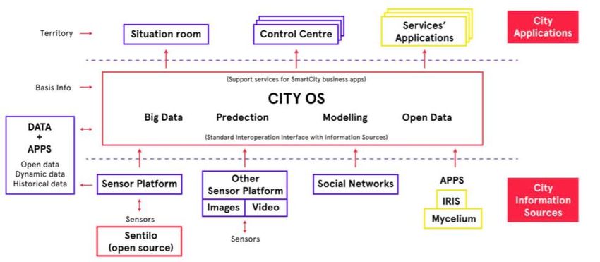
2.2 Data provision
BCNNOW will be connected to CityOS via public API. Regarding the CityOS data
available, it will work with both internal City Council data and with external agencies’
data with information on the city that are under municipal control, albeit not directly
managed by City Council institutions.

The available internal City Council data are:
    ● Adjudication of contracts.
    ● Subsidies.
    ● Municipal Action Plan projects.
    ● Districts.
    ● Open Data BCN*2. Open data infrastructure of the city with several public
    datasets.
    ● Sentilo*. The sensor platform of the city.
    ● IRIS*.The platform that stores citizen demands and requirements.
    ● ASIA*. The platform that stores the agenda of all public activities and record
    record all city buildings usage.
    ● Decidim Barcelona*
External agencies:
       ●        Other public sensor platforms.
       ●        Video platforms.

2.3 Infrastructure
In order to connect to the CityOS platform with BCNNow infrastructure, CityOS has
made available a provisional API that allows to reach their Web Feature Service (WFS)
publisher3. Once a request has been performed from BCNNow infrastructure to CityOS
platform, the INET API Connect gets the petition and redirects it to the Corporate API
Connect, then following the same flow it is sent to the City OS API Manager, where the
procedure to consume the datasets available is started.

The following schema shows the CityOS technical architecture and how it is connected

2 All the data sources termed with * were already connected (using a different approach) to
BCNNow in the context of deliverable D5.1.
3 For more detailed information see chapter 3. Technical connections details.

H2020-ICT-2016-1                           DECODE                      D5.2 CityOS connection
                                                 9
with BCNNow.
Figure 4: BCN Urban Platform high level integration
Figure 5: CityOS high level infrastructure and connection to BCNNow.
H2020-ICT-2016-1 DECODE D5.2 CityOS connection
102.4 Connection status
The status of the connection is in the testing phase, non production. CityOS staff holds it
in the last step of validation, just pending to the internal security test to be put in
production stage.
H2020-ICT-2016-1 DECODE D5.2 CityOS connection
113 Technical connection details
3.1 CityOS Data Description
The CityOS Data Collector was linked to BCNNOW infrastructure considering the
characteristics of the Web Feature Service (WFS) "cityos:ptt_carril_bici" and
“cityos:potencial_fotovoltaic”, through a Provisional API provided by the “Institut
Municipal d’Informàtica (IMI) del Ajuntament de Barcelona”. CityOS is connected via
private access token (TBD). The WFS "cityos:ptt_carril_bici" is related with qualified areas
which the regulations establish as exclusively destined for the circulation of bicycles,
those that the signaling allows and those for which there is an express authorization
(Ajuntament de Barcelona, 2018). On the other hand, the WFS
“cityos:potencial_fotovoltaic” is related to the solar and thermal potential of the roofs
of Barcelona (Ajuntament de Barcelona, 2013).
The characteristics of each source of information are presented in Tables 1 and 2.
HEADER CONTENT
G URLs http://ajuntament.barcelona.cat/digital/en/digital-transformation/city-data-commons/cityos (CityOS
E Blog).
N http://opendata-ajuntament.barcelona.cat/data/es/dataset/carril-bici ("Carriles Bici de la ciudad de
E Barcelona” in Open Data BCN).
R Short Description Bicycle lanes in the city of Barcelona. The data doesn't provide information on the directionality of the
A Bicycle lanes.
L Provision Constraint -
I Provision Method Batch process update to Web Feature Service (WFS) with OAuth2 authentication.
N Update Rate Weekly.
F
O Historical Data? -
R Connection Type Batch CityOS API.
M
A Access Permission Private.
T
Data Format JSON.
I
O Status Available.
N
Current Size TBD
Original Record Structure Geometry coordinates (latitude-longitude pairs in CRS “EPSG:25831”) ∙ Geometry type (LineString).
EventCode (Integer) ∙ ID1 (Integer) ∙ ID2 (String) ∙ MD_DATA_PUBLISHED (Year/Month/Day/Hour) ∙
MD_DATA_QUALITY (empty) ∙ MD_DATA_STRUCTURED (String) ∙ MD_DELTA_MODE (String) ∙
MD_ID_PROCES MD_DELTA_MODE (String) ∙ MD_IMPORT_MODE (String) ∙ MD_LOPD (Integer) ∙
MD_NORM_JOB_NAME (String) ∙ MD_NORM_TIME (String) ∙ MD_PRIORITY (Integer) ∙ MD_RAW_TIME
(unix timestamp) ∙ MD_ROW_IS_VALID (String) ∙ MD_SECURITY_LEVEL (Integer) ∙ MD_SRC_ENTITY (String) ∙
MD_SRC_SYSTEM (String) ∙ MD_SRC_TIME (String) ∙ MD_VALIDATION_TIME (String) ∙ NOM_FINAL (String) ∙
TYPE_GEOMETRIA (String).
D Data Collection Type -
A
Source Data Preprocessing Coordinates conversion Custom ED50 to WGS84:
T
ED50 / UTM zone 31N (long_cityos:ptt_carril_bici/ 1000 + 400000, lat_cityos:ptt_carril_bici / 1000 +
A
4500000)
L Source Structure Adaption “ID”: item['properties']['ID'],
A “SOURCE”: “cityos:ptt_carril_bici”,
Y “PROVIDER”: "cityos",
E “PUBLISHER”: None,
“TYPE”: "ptt_carril_bici",
H2020-ICT-2016-1 DECODE D5.2 CityOS connection
12HEADER CONTENT
R “LOCATION": {
“LONGITUDE”: CENTROID().X,
I “LATITUDE”: CENTROID().Y,
N “ALTITUDE”: None,
F “DISTRICT”: DISTRICTE,
O “BARRI”: BARRI,
R “STREET_TYPE”: TIPUS_VIA,
M “STREET_NAME”: CARRER,
A “STREET_NUMBER”: NUMERO,
T “CITY_NAME”: “Barcelona”
I "GEOMETRY":
O }
N “TIMESTAMP”: C(item['properties']['MD_DATA_PUBLISHED']),
“PAYLOAD”: {
“Id1”: ID1,
“Id2”: ID2,
“EventCode”: EVENTCODE,
}
Source Duplicates ID1 and ID2 do not exist in ALL(PAYLOAD.Id1, PAYLOAD.Id2).
Checking
Table 1: Characteristics of the information integrated in the Bicycle lanes data collector.
HEADER CONTENT
G URLs http://ajuntament.barcelona.cat/digital/en/digital-transformation/city-data-commons/cityos (CityOS
E Blog).
N
E Short Description Solar Map of Barcelona - Potential of roofs for photovoltaic and thermal use.
R
A Provision Constraint -
L Provision Method Batch process update to Web Feature Service (WFS) with OAuth2 authentication.
I Update Rate -
N Historical Data? -
F
O Connection Type Batch CityOS API.
R Access Permission Private.
M
A Data Format JSON.
T Status Available.
I
O Current Size TBD
N
Original Record Structure Geometry coordinates (latitude-longitude pairs in CRS “EPSG:25831”) ∙ Geometry type (Polygon).
BUILDID (String) ∙ CNT_BUILD_ (Integer) ∙ CO2_TH (Integer) ∙ CODIFICACIO (String) ∙ ELEMENT (String) ∙
EventCode (Integer) ∙ ID1 (Integer) ∙ MD_DATA_PUBLISHED (Year/Month/Day/Hour) ∙ MD_DATA_QUALITY
(Integer) ∙ MD_DATA_STRUCTURED (String) ∙ MD_DELTA_MODE (String) ∙ MD_ID_PROCESS (String) ∙
MD_IMPORT_MODE (String) ∙ MD_LOPD (Integer) ∙ MD_NORM_JOB_NAME (String) ∙ MD_NORM_TIME
(String) ∙ MD_PRIORITY (Integer) ∙ MD_RAW_TIME (unix timestamp) ∙ MD_ROW_IS_VALID (String) ∙
MD_SECURITY_LEVEL (Integer) ∙ MD_SRC_ENTITY (String) ∙ MD_SRC_SYSTEM (String) ∙ MD_SRC_TIME
(String) ∙ MD_VALIDATION_TIME (String) ∙ POW_TH (Integer) ∙ SUITABILITY (String) ∙ SUM_MODARE
(Integer).
D Data Collection Type -
A
Source Data Preprocessing Coordinates conversion Custom ED50 to WGS84:
T
ED50 / UTM zone 31N (long_cityos:potencial_fotovoltaic/ 1000 + 400000, lat_cityos:potencial_fotovoltaic /
A
1000 + 4500000)
L Source Structure Adaption “ID”: item['properties']['ID'],
A “SOURCE”: “cityos:potencial_fotovoltaic”,
Y “PROVIDER”: "cityos",
E “PUBLISHER”: None,
R “TYPE”: "potencial_fotovoltaic",
“LOCATION": {
H2020-ICT-2016-1 DECODE D5.2 CityOS connection
13HEADER CONTENT
“LONGITUDE”: CENTROID().X,
I “LATITUDE”: CENTROID().Y,
N “ALTITUDE”: None,
F “DISTRICT”: DISTRICTE,
O “BARRI”: BARRI,
R “STREET_TYPE”: TIPUS_VIA,
M “STREET_NAME”: CARRER,
A “STREET_NUMBER”: NUMERO,
T “CITY_NAME”: “Barcelona”
I "GEOMETRY":
O }
N “TIMESTAMP”: C(item['properties']['MD_DATA_PUBLISHED']),
“PAYLOAD”: {
“id”: id,
“PowTh”: POW_TH,
“EventCode”: EventCode,
“Suitability”: SUITABILITY,
“SumModare”: SUM_MODARE,
}
Source Duplicates id does not exist in ALL(PAYLOAD.id).
Checking
Table 2: Characteristics of the information integrated in the Photovoltaic (PV) potential data collector.
3.2 Connection with CityOS API
The CityOS platform uses the WFS specification version 1.1.0 and supports both GET and
POST HTTP methods (Table 3). The platform implements three operations defined by the
WFS standard:
Operation Description
GetCapabilities Retrieve service metadata.
DescribeFeatureType Generate a schema description of features types serviced by the
service.
GetFeature Retrieve features from the service and output them using the JSON
representation.
Table 3: Web Feature Service (WFS) specifications provided by the CityOS platform.
When the HTTP GET method is used, the parameters are appended to the URL using a
Keyword Value Pair (KVP) encoding. Table 4 presents the list of the common
parameters, supported by all WFS operations.
Operation Description Possible values
service The requested service. WFS
request The requested GetCapabilities, DescribeFeatureType, GetFeature
H2020-ICT-2016-1 DECODE D5.2 CityOS connection
14operation.
version The requested version of 1.1.0
the service.
Table 4: Parameters supported by the CityOS WFS operations.
An authenticated user with OAuth 2.0 can be granted access to both restricted
datasets and benefit from extended quotas for API calls. The API features an
authentication mechanism for users to be granted their specific authorizations.
For the CityOS platform to authenticate a user, the CityOS collector shall include the
following elements:
● Token OAUTH2 obtained with https://apigateway.bcn.cat/imi/cityosinet/imi-
oauth-provider/oauth2/token
● Grant_type: "client_credentials":
"X-IBM-Client-Id"
"X-IBM-Client-Secret"
● Authorization: "Bearer + Access Token (e.g.
AAIkODE4NzNkMjAtYmFhMy00ZGZiLTkyZjctOWE3OTViYjkwNTI4HJGNpDA9y_LARV
mFvOERESFbEySHWiz2pfiFmnoqMsu0-
1X82VnmytYCMzTLAZnlp5rFzMjtjfohy3GvNm2moVIk6a4fZBExTPmFcuQ4oYNQ54hD
NYmtVqxDVzHzpkMA).
● Scope: none.
Passing the API key of an authorized user will return the JSON response with the list of
accessible datasets for this user.
Therefore, the Get requests can be consumed by the API of BCNNOW and visualized
through the BCNNOW dashboard, which provides an interface allowing requests for
geographical features (Figure 4). The vector data deployed through the collector such
as geographic coordinates, points, lines, and polygons describing points, lines and
areas are stored as geospatial data in MongoDB, allowing the execution of temporal
and spatial queries on a CityOS collections that contains geospatial shapes (lines and
polygons and points). These data can be used by the BCNNOW dashboard, and
displayed on the screen using scalable shapes, labels, legends and widgets (Figures 5, 6
and 7).
H2020-ICT-2016-1 DECODE D5.2 CityOS connection
15Figure 6: Workflow for the connection of CityOS with BCNNOW infrastructure.
Figure 7: Barcelona Now dashboard with the representation of the WFS "cityos:ptt_carril_bici" as lines in the
city map.
H2020-ICT-2016-1 DECODE D5.2 CityOS connection
16Figure 8: Barcelona Now dashboard with the representation of the WFS "cityos:ptt_carril_bici" as lines in the
city map, together with coloured circles representing bicing bikes availability.
H2020-ICT-2016-1 DECODE D5.2 CityOS connection
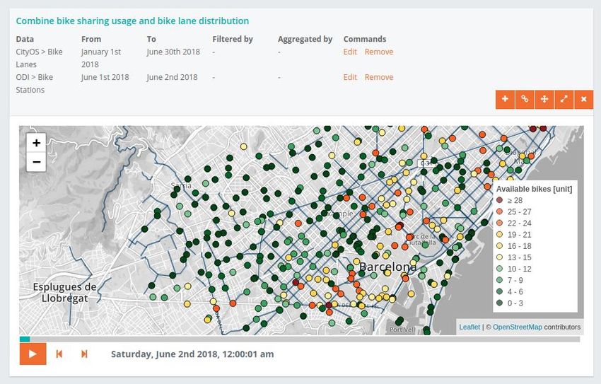
17Figure 9: Barcelona Now dashboard with the representation of the WFS "cityos:potencial_fotovoltaic" as
polygons in the city map.
H2020-ICT-2016-1 DECODE D5.2 CityOS connection
183.3 CityOS Connection to BarcelonaNow
The two Web Feature Service (WFS) are presented as geographic data according to
Open Geospatial Consortium (OGC), in the coordinate system ETRS89 / UTM zone 31N
(EPSG:25831). The WFS "cityos:ptt_carril_bici" is composed of data about geo-located
features represented primarily by lines. On other hand, the WFS
“cityos:potencial_fotovoltaic” is composed of data about geo-located features
represented primarily by polygons (Table 5).
CityOS WFS Geometry attributes
cityos:ptt_carril_bici ● Geometry coordinates (e.g. latitude-longitude pairs for the Id '187':
[[166021.44309607, 0, 0], [166021.44309607, 0, 0]])
● Geometry type - 'LineString'
● Geometry name - 'GEOMETRY'
● CRS: 'EPSG:25831'
cityos:potencial_fot ● Geometry coordinates (e.g. latitude-longitude pairs for the Id '1342':
ovoltaic [[[425419.26009317, 4576451.42906721, 0],
[425419.26009317, 4576451.42906721, 0],
[425424.34109316, 4576440.5500672, 0],
[425428.57009315, 4576431.50906719, 0],
[425380.73109321, 4576409.30006716, 0],
[425378.83109321, 4576404.22006716, 0],
[425375.58109322, 4576391.63906714, 0],
[425406.57009318, 4576355.3790671, 0],
[425405.22109318, 4576351.8140671, 0],
[425400.72109318, 4576339.91006708, 0],
[425391.1010932, 4576331.73006707, 0],
[425373.23409322, 4576352.14406709, 0],
[425354.95109324, 4576373.03006712, 0],
[425355.92009324, 4576375.62906712, 0],
[425357.16109324, 4576377.61006712, 0],
[425361.22109323, 4576384.38906713, 0],
[425336.26009327, 4576413.13906717, 0],
[425333.70109327, 4576411.92906716, 0],
[425331.73109327, 4576416.11006717, 0],
[425330.85109327, 4576418.30006717, 0],
[425416.07009317, 4576458.25906722, 0],
[425419.26009317, 4576451.42906721, 0]]] )
● Geometry type - 'Polygon'
● Geometry name - 'GEOMETRY'
● CRS: 'EPSG:25831'
Table 5: Geometry attributes of the CityOS WFS.
The CityOS collector in addition to the authorization credentials and token OAUTH2 URL,
also required the implementation of standardization of the source data and specific
geographic functions related to the geometries associated with the two services, lines
and polygons.
H2020-ICT-2016-1 DECODE D5.2 CityOS connection
19The integration of data from WFS with a new access method requires a pre-processing
step in order to provide a unified view of them. The pre-processing phase receives the
original data provided by the CityOS WFS, and transforms them to a standardized JSON
format. For each data source, attribute names have been translated to English. The
implementation of the data model of the CityOS collector was based on the GIS
Metadata and on the Data Documentation of both WFS, provided by IMI.
The CityOS collector has its folder with four files: a configuration file, two payload
definition files, and an execution file.
● The first one, the configuration file, includes a Python class that defines a JSON
record with all the configuration parameters needed by the collector. The
CityOS collector requires the definition of the following configuration variables:
○ Source name.
○ Token URL.
○ Base URL.
○ WMS for the datasets "cityos:ptt_carril_bici" and
"cityos:potencial_fotovoltaic".
○ Token credentials:
■ Client Id.
■ Client secret.
■ Headers "X-IBM-Client-Id" and "X-IBM-Client-Secret".
○ Authorization grant type: "client_credentials".
○ Scope: "none"
● The second and third ones, the payload definition files, contain a Python class
with all the record attributes which are specific of that kind of data source,
getter and setter methods, and a method which returns a JSON record
containing all the tabular attributes. Table 6 shows the structure of the payload
field for an instance of a CityOS Base Record (one for each CityOS service).
CityOS payloads Tabular attributes
CityOSBicycleLanesPayload ● Id1(e.g. '187')
● Id2 (e.g. 'PTT_CARRIL_BICI.836')
● EventCode (e.g. '051')
CityOSPVPotentialPayload ● Id (e.g. '1342')
● PowTh (e.g. '794')
● EventCode (e.g. '051')
● Suitability (e.g. 'very good')
● SumModare (e.g. '19')
Table 6: Tabular attributes integrated in the payload of CityOS WFS.
H2020-ICT-2016-1 DECODE D5.2 CityOS connection
20● The fourth one, the execution file, contains a Python class with four methods:
start() is the main method whose purpose is to loop for all the files to be
accessed or all the API calls to be executed. For API access, it calls the
sendRequest() which takes a URL as parameter and returns the data retrieved
from that URL. According to the access method, sendRequest() is able to get
data in JSON format by using the proper Python package. Once the data is
retrieved, start() calls saveData(). This method has the purpose of accessing
each record represented in the original format, calling buildRecord() to create
an instance of the record coded in the internal unified format for that data
source and using store() from StorageHelper to save the record into MongoDB
(Figure 8). It should be emphasized that for each instance (‘CityOS Base
Record’), the payload field structure depends on the specific data source that
we considered, so we have a different structure for each data source.
Concerning the transformation of Coordinate Reference System (CRC), the
coordinates of the CityOS standard (ETRS89 / UTM zone 31N (EPSG:25831)) had to
be converted to WGS84 standard (EPSG:4326).
Finally, the centroid creation function (lines to points and polygon to points) was
also implemented in the execution file.
Figure 10: UML Sequence Diagrams: CityOS Collector.
H2020-ICT-2016-1 DECODE D5.2 CityOS connection
21The public data records are stored into Decode MongoDB. At the moment, we have
the following CityOS collections:
● "cityos:ptt_carril_bici": (299 records). Information on bike line geometries in Barcelona.
● “cityos:potencial_fotovoltaic”: (over 112.000 records). Information on green solar
energy production of building roofs (polygon geometry) in Barcelona.
H2020-ICT-2016-1 DECODE D5.2 CityOS connection
22Conclusions
This deliverable further consolidates the BCNNow tool sketched and deployed
throughout D5.1 and D5.3 by adding a new connection to the city council data
infrastructure. It provides a technical description of the connection as well as a frame
where to place both BCNNow and the CityOS (the data lake of the city council) within
the context of the DECODE project.
This feat marks an important hallmark as it further interconnects the DECODE project to
an advanced Big Data tool that can be considered as integral part of the core data
infrastructure of the city council. Achieving such a connection has allowed also to
develop research on the dynamics and procedures needed for widen DECODE
adoption into administrative institutions.
With this new addition, the BCNNow tool closes its initial phase of acting as a public
dashboard. While BCNNow already adds a lot of value providing a unique, centralized,
and customizable visualization tool for a group of datasets never gathered together
before, by starting a second phase of development, we aim to allow, in conjunction
with other DECODE technologies being developed in the context of the project, for a
more personalized experience and control over data gathered by users in a privacy-
respectful way.
This second stage of BCNNow will be permanently informed by the evolution of the
pilots and the feedback produced with the iterative and agile methodology being
used therein.
H2020-ICT-2016-1 DECODE D5.2 CityOS connection
23References
Ajuntament de Barcelona (2018). Bicicleta. Retrieved from
http://ajuntament.barcelona.cat/bicicleta/es/servicios/vias-de-circulacion/tipo-de-
via/carriles-bici
Ajuntament de Barcelona (2013). Mapa Solar de Barcelona - Potencial de les cobertes
per a ús fotovoltaic i tèrmic. Infraplan Barcelona SL. Document: 130225_Public Solar
BCN.pdf, Data: 25/02/2013.
Ajuntament de Barcelona (2018): Government Measure concerning ethical
management and accountable data: Barcelona Data commons
https://ajuntament.barcelona.cat/digital/sites/default/files/2018_mesuradegovern_en.
pdf
H2020-ICT-2016-1 DECODE D5.2 CityOS connection
24You can also read