Coastal Modelling 101 - Mitchell Smith Australian Water School Webinar 19th May 2021
←
→
Page content transcription
If your browser does not render page correctly, please read the page content below
Coastal Modelling 101
Mitchell Smith
Australian Water School Webinar 19th May 2021
Introduction
Coastal Modelling vs Flood Modelling

The Challenge

The Astronomical Tide

Climate, Weather and the Ocean

Spectral Wave Modelling

Review and Conclusions
Introduction
This presentation is a short ‘taster’ in coastal modelling

The examples developed today are from TUFLOW FV and SWAN

Aimed at new coastal modellers or with those interested in
understanding more.

I’ve kept the theory to a minimum

If you’d like to understand more check out ‘Astronomical Tide’
and ‘Waves’ pages of: coastalwiki.org/wiki/Main_Page

Please ask lots of question in the Q & A line.
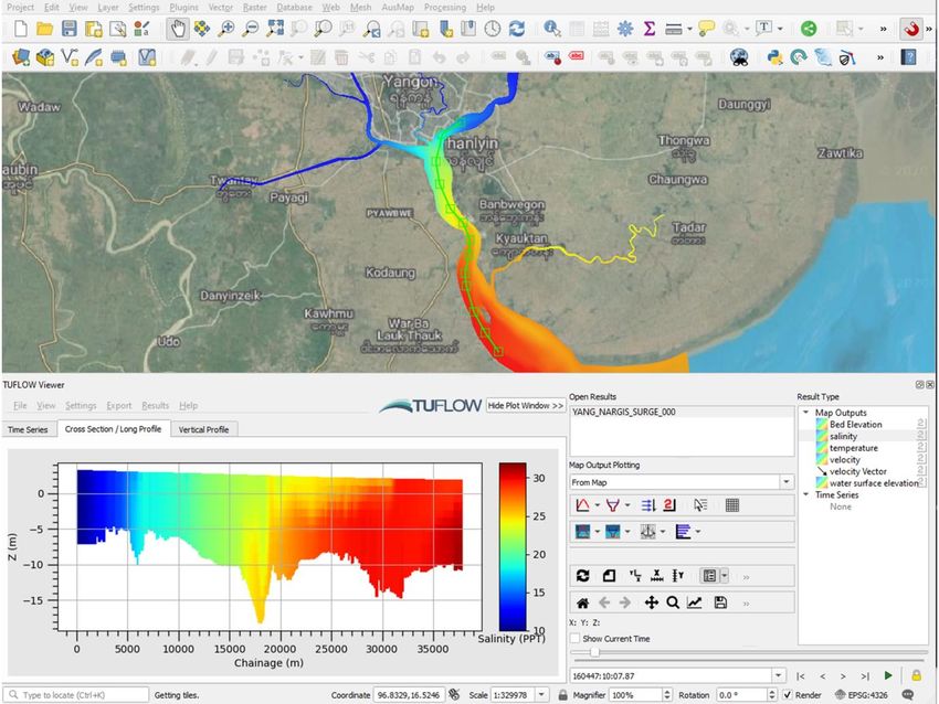
TUFLOW FV TUFLOW’s Flexible Mesh Engine and
Environmental Toolkit
•   1D, 2D & 3D (CPU or GPU) Hydrodynamics

•   Advection-Dispersion/Diffusion

•   Atmospheric Heat Exchange

•   Sediment Transport

•   Water Quality

•   Particle Tracking

•   Windows or Linux OS

•   Spectral Wave Coupling (Single or Two-way)

•   Range of Utilities, Python/MATLAB Libraries

•   QGIS, SMS, GIS Mesher, SWAN GIS Tools

                                     https://www.tuflow.com/products/tuflow-fv/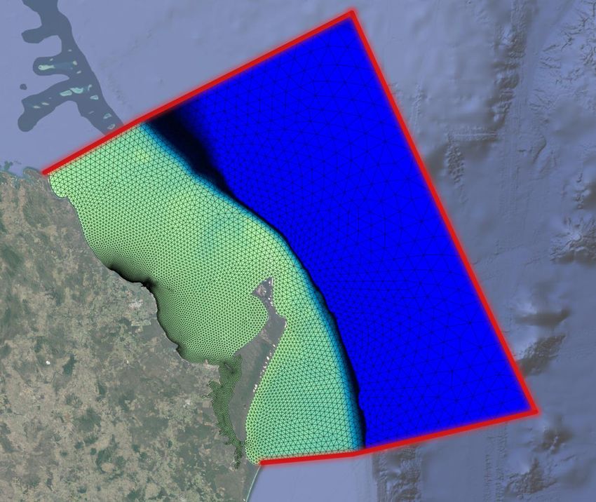
Modelling – A few definitions for this talk…
Rivers and Flood modelling – The areas of our
catchments influenced primarily by rainfall and to a
lesser extent groundwater

Estuaries – the region where the astronomical tide
and riverine systems meet and mix

Coastal* – Seaward of the coastline 100-250km

Ocean circulation models – Global and model
offshore processes
Flood and Coastal Model Interactions
Coastal processes that affect flood modelling        River processes that affect coastal modelling

Tailwater (Astronomical Tide, Storm Tide, Static)    Freshwater river flows can be important in the
                                                     estuary
River mouth morphology
                                                     Do flood flows affect the ocean level?
Interaction of salt and freshwater can affect flow
behaviour – stratification, however for big floods   Coastal sediments and nutrients
this is typically reduced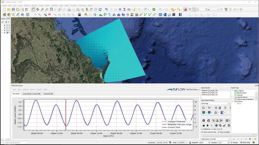
Coastal Modelling – A few applications

Coastal and fluvial inundation   Port development/optimisation       Contaminant or species fate

Storm tide                       Marine structure analysis           Aquaculture

Tsunami                          Capital and operational dredging    Ocean outfalls and point source
                                                                     discharges
Wave overtopping                 Ship navigation and route
                                 optimisation                        Ocean, lake and estuarine water
Stratified systems
                                                                     quality, algal blooms, plankton etc.
                                 Morphological analysis, bed scour
Coastal protection design
                                 and deposition                      Animal migration
Metocean and offshore design
                                 Beach morphology                    Salvage, rescue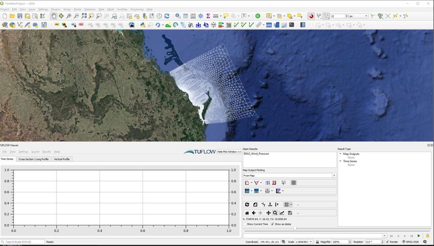
Scale

                    Flooding                      Coastal                          Ocean

Temporal Scale      Hours to days                Hours to years             Days to hundreds of years

Spatial Scale    Meters to kilometres   Meters to thousands of kilometers            Global
Processes
Rainfall is no longer the star of the show…

Astronomical Tides

The interaction between the atmosphere and ocean is
important

Coastal model boundary conditions tend to use gridded
inputs – vary in space and time

3D effects often need to be considered, salinity, temperature

Waves
The Challenge
The Challenge
Build a coastal hydrodynamic model to match the observed water level
Urangan – 24th -30th January 2013
The Steps
1. Develop the model domain

2. Run with the astronomical tide only

3. Run with astronomical tide + meteorological influences (Air pressure and wind)

Along the way I’ll discuss:

1. The various datasets we need

2.   The physical processes
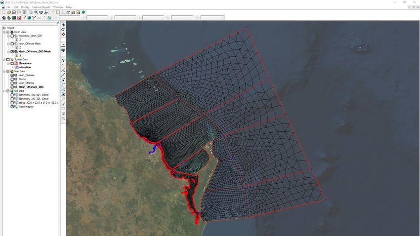
1. Develop a Hydrodynamic Model
Coastal vs. Flood Models
Both types of models require similar features

Bathymetry/Topography

Computational Grid/Mesh

Boundary Conditions

Model Selection i.e. bed roughness, turbulence

Calibration!!!
TUFLOW FV
Computational
Domain
Bathymetry
Admiralty Charts (Analogue or digital)

Online data services

Estuaries – Often have to source new
data (survey) or derive from cross
sections

Storm tide/Tsunami – LiDAR
2. Run an Astronomical Tide Only Model
Why are the Astronomical Tides Important?
Water levels and currents

Intertidal areas – mangroves,
mudflats, seagrass

Coastal morphology, beaches

Coastal infrastructure

Navigation
Where the tides start and end for a lot of flood modellers

             https://www.msq.qld.gov.au/Tides/Tidal-planes
Astronomical Tide
Long period waves driven by the differences in gravitational
attraction at various locations on our rotating earth to the
moon and sun
Time of year, changes in the moon’s orbit, earth’s orbit and
the earth’s axial tilt affect the tides
Can be broken down into a series of partial tides called tidal
constituents
These forces are influenced by the continents, ocean
bathymetry and Coriolis Force
And thus the tides differ greatly across the globe
https://climate.nasa.gov/climate_resources/246/video-global-ocean-tides/Tidal Constituents
Astronomical Tide
                    Coral Sea Eastern Australia
South Western AustraliaAstronomical Tide
Coral Sea Eastern AustraliaAstronomical Tide
Coral Sea Eastern Australia
In PhaseAstronomical Tide
Coral Sea Eastern AustraliaAstronomical Tide
Coral Sea Eastern AustraliaAstronomical Tide
Coral Sea Eastern AustraliaAstronomical Tide
Coral Sea Eastern AustraliaAstronomical Tide
Coral Sea Eastern AustraliaAstronomical Tide
Coral Sea Eastern Australia
How do we know what these are?Astronomical Tide
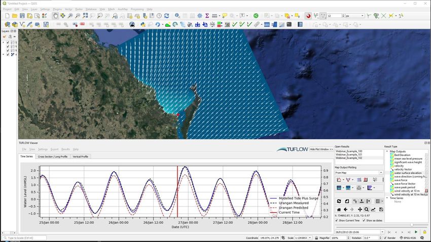
Western Australia2. Run an Astronomical Tide Only Model Model setup One month simulation January 2013 Source and apply astronomical tide boundaries Calibrate to tidal predictions at Bundaberg and Urangan
Tide Data
Water level point predictions

Gridded tidal predictions

https://www.esr.org/research/polar-
tide-models/tmd-software/

https://pypi.org/project/pyTMD/

We have tools to assist with using
these
Model Simulation
One month Jan 2013
Time and spatially varying water level boundaries (Astronomnical Tide)
Compared to tidal predictions at Bundaberg and Urangan
Astronomical Tide Calibration

Model Simulation
One month Jan 2013
Time and spatially varying water level boundaries (Astronomnical Tide)
Compared to tidal predictions at Bundaberg and Urangan
The Challenge
Build a coastal hydrodynamic model to match the observed water level
Urangan – 24th -30th January 2013
Climate, Weather and the Ocean
Climate, Weather and the Ocean
Ocean and atmosphere are intimately coupled
Differential heating of the earth
Redistribution of heat drives atmospheric circulation
This in turn ‘pushes’ the ocean around affecting ocean
circulation
Storms are embedded as weather events in these
larger climate and oceanic processes
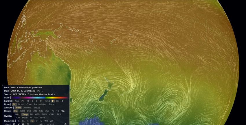
https://earth.nullschool.net/about.htmlClimate, Weather and the Ocean
Winds tend to ‘push’ the ocean around and in
turn ocean temperature can affect the wind
Ocean currents lead to convergence,
divergence, upwelling, downwelling
Western boundary currents
Wind or density driven currents
https://earth.nullschool.net/about.htmlHow do we model the weather, climate, ocean anomalies? So how do we allow for these effects… Well we are lucky in 2021 Meteorological (NOAA/NCEP ECMWF BoM) Mean sea level pressure and wind speed Air temperature, relative humidity, short and longwave radiation, cloud cover, precipitation (For 3D modelling not covered today) Ocean (HYCOM BRAN2020 Copernicus) Wind waves Salinity, temperature, currents, mean sea surface anomalies (3D modelling, not covered today)
How do we model the weather, climate, ocean
anomalies?
So how do we allow for these affects…
How do we model the weather, climate, ocean
anomalies?
Show weather data on model
The Challenge
Build a coastal hydrodynamic model to match the observed water level
Urangan – 24th -30th January 2013
Discussion
Passage of a storm created a storm tide at Urangan

Good astronomical tide calibration

Modelling of astronomical tides only was not enough to reproduce observed water levels

Inclusion of gridded wind and pressure data required
Extending the Challenge
During the storm a fishing boat capsized and sank

An investigation needs to be completed to estimate the
wave conditions at the wreck site at the peak of the event

Significant wave height and peak wave period

To answer these questions we need to shift our thinking
from currents and water levels to wind waves
Spectral Wave Modelling
Wind Waves
Sea is a complex combination of waves with different
directions, heights and speeds

Generated by shear and resonance by the wind

The longer and harder the wind blows over a given
fetch the larger the waves grow until equilibrium

Sea waves and swell waves
Why are Ocean Waves Important?
Distribute energy

Upper ocean mixing

Structural design

Navigation

Sediment transport and coastal
morphology

Recreation

                                 https://www.abc.net.au/news/2021-04-12/port-fairy-big-surf-damage-sea-level-rise/100063670
Estimating Wave Conditions Build a spectral wave model Model the evolution of wave energy Wave dissipation, wave generation, wave interactions, wave setup and much more. ‘Coastal wave model’ SWAN – Delft University of Technology http://swanmodel.sourceforge.net/ ‘Offshore wave models’ WAVEWATCH III, WAM
SWAN GIS Tools
SWAN GIS Tools (Free with TUFLOW QGIS Plugin)

Not a wave model – Developed by TUFLOW to
help you build SWAN wave model domains and
input files with GIS

Builds .swn control files, wave spectra, nesting
(where relevant), bathymetry, wind files.

Released soon. Contact support@tuflow.com if
you would like to try it out.
Waves
Data

Modelling process

SWAN >> Then drop into TUFLOW FV
Spectral Wave Model Outputs
To address our brief we need to report:

1. Significant wave height (average of the highest 1/3 of waves)

2. Peak wave period (the time between successive wave crests)

These are output directly by SWAN along with many other optional outputs
Waves
Results

We are interested in significant wave height (average of the highest 1/3 of waves)

Peak wave period (the time between successive wave crests)

                                      4m

                                      9s
Integrating Wave and Hydrodynamic Models Wave model outputs can be applied to TUFLOW FV to affect currents and water levels Can be used as inputs to TUFLOW FV’s sediment transport module Can also be run together in coupled mode with TUFLOW FV https://awschool.com.au/resources/webinar-2d-and-3d-sediment-transport-and-morphological-modelling/
Review and Conclusions
Conclusions
Flood and ocean models aren’t too different

The scale and the processes that we need to include are different (noting we didn’t go 3D today)

Water levels and currents due to the astronomical tides vary across the globe in time and space

The ocean and the atmosphere are intricately coupled to each other

Water levels at the coast often exceed the predicted astronomical tide (due to ‘tidal residuals’)

Ocean wind waves are an important process to consider
Conclusions
Models help us to extend our knowledge away from measurements and also allow scenarios and
designs to be tested

Calibration

There are great models out there, however ultimately it’s how we use them…
Thank you!!!

           Q                     A

               info@tuflow.com
You can also read