COHSAT LOW CARBON HUB PROJECTS 2020 2021
←
→
Page content transcription
If your browser does not render page correctly, please read the page content below

CoHSAT Low Carbon Hub Projects 2020 – 2021

About CoHSAT .................................................................................................................................................................................. 1
Healthy Streets and Active Travel, 2020-2021 – summary of findings ........................................................................ 2
1. The opportunities to convert St Giles into a public space ........................................................................................... 6
2. Creation of a Popup Experience on projects to improve active travel in Oxford .............................................. 10
3. Advice Guide - The provision of good quality, on-road cycle parking where none exists at present ...... 14
4. Assisting the development of new Healthy Streets and Active Travel groups in several market towns.. 17
5. Feasibility of producing a 15 minute neighbourhood tool to understand Walkability in Oxfordshire .... 20

CoHSAT undertakes a number of projects each year. This is the report for our projects for 2021-2022.
With thanks to the Low Carbon Hub for its essential support.

For further information on our five projects for 2020-2021 and other CoHSAT activities see
http://www.cohsat.org.uk or email us at info@cohsat.org.uk.

About CoHSAT
The Coalition for Healthy Streets and Active Travel (CoHSAT) is a group of voluntary and campaigning
organisations working across Oxfordshire to create attractive, accessible and people-friendly streets. We
will do this by encouraging efficient, active, low carbon and sustainable travel, which will reduce traffic,
air pollution and noise, and enable healthy and thriving communities. More details can be seen at
http://www.cohsat.org.uk.

The 10 CoHSAT members are: Low Carbon Oxford North, Low Carbon West Oxford, Pedal and Post,
Oxford Friends of the Earth, Oxford Pedestrians Association, Oxford Civic Society, Cyclox, Rose Hill and
Iffley Low Carbon, Oxfordshire Liveable Streets and Oxfordshire Cycling Network.

Healthy Streets and Active Travel, 2020-2021 – summary of findings

Our five activities have focused primarily on awareness-raising and education. We are particularly
delighted about the success of the popup shop and that we have helped six of the market towns take up
active travel initiatives. The Walkability Index is a unique contribution to identifying neighbourhoods that
lack amenities within easy access. The data project will help groups access active travel data which
support their researches and discussions on the way that active travel is developing in Oxfordshire. And
our briefing paper on Bike Hangars provides the launch-pad for Oxford City Council and Oxfordshire
County Council to make cycle parking safer.
 We have enjoyed undertaking these five activities and hope that our findings will promote action on
active travel and healthy streets in Oxfordshire.

The opportunities to convert St Giles into a public space

The time has come to transform St Giles, to make it a more important attribute in Oxford’s historic centre
through a focus on pedestrians and cyclists, rather than cars and parking. The County Council has been
proposing substantial, but piecemeal, changes since 2016, but has not activated them yet. The public are
extremely enthusiastic about the benefits of a newly-configured space. And changes, such as removing
the parking, could happen now, without being dependent on any other city-centre developments. The
narrowing of the traffic lanes could similarly occur, though would be more sensible if linked to the
installation of the Worcester Street bus gate. Any loss in revenue from the car-parking would be offset by
re-invigorating the whole area with new cafés, greenery, florists, sculptures and even an Oxford Eye (a
smaller version of the London one). As the retail sector declines, post-Covid, the benefits of new
attractions are needed to enhance the City’s historic centre. Similar arguments apply to Broad Street as
we portrayed last year.

Led by Low Carbon Oxford North, CoHSAT gives an inspirational overview of what this important
townscape could look like. All that is needed now is the political determination to deliver a new and
inspiration piece of public realm for Oxford.

Creation of a Popup Experience on projects to improve active travel in Oxford

CoHSAT opened a popup shop in the centre of Oxford to feature projects that improve active travel in
Oxford. It was open from 26 July to 1 August 2020. There were 360 visitors, mainly those already
interested and semi-knowledgeable about the proposals. There were 14 major initiatives displayed
representing options that would improve many areas of Oxford – not all in the City centre. We believe
the shop has advanced awareness of what could be achieved while making the City healthier, safer and
more attractive, whether for pedestrians or cyclists, residents or tourists.

The most support was given to our proposals for:
   • Broad Street to be car-free;
   • St Giles to be mainly pedestrianised, with no parking and narrower road;
   • Hythe Bridge Street to be pedestrianised and Worcester Street car park made into a public space
   • Iffley Road with wide, segregated cycle paths and off-street parking;
   • Low Traffic Neighbourhoods (LTNs) – with several requests for new areas, eg Marston,
      Wolvercote, Kennington, Littlemore, New Hinksey.

                                                                                                   Page 2 of 23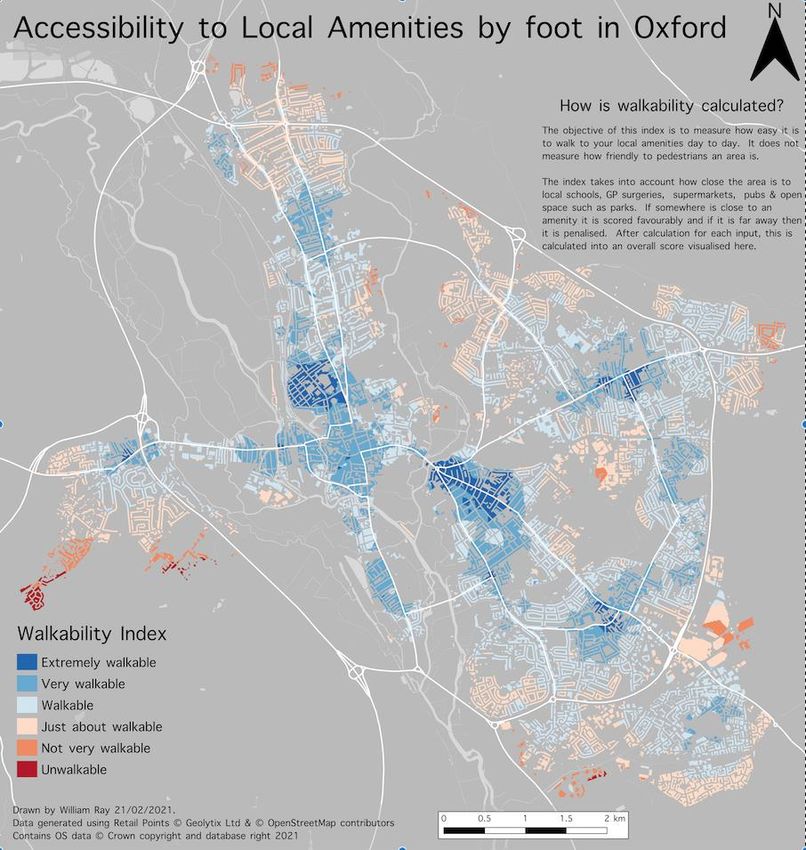
There was little support for proposals to make Cowley Road and the High Street one-way and, generally,
there is widespread concern about how the disabled and elderly move around. Bus gates were the focus
of considerable debate. Over half our visitors were supportive and many of the remainder were happy to
have accurate information and to enter into reasoned discussions. Generally, those in support of bus
gates are looking at the wider Oxford picture, whereas many of those most worried have a personal
perspective and would need to make real changes to their lives, so timing and communications are key
to allow for these adjustments.

CoHSAT is delighted to have run the shop and particularly glad that so many people demonstrated their
support and pleasure at the exhibition. We had a lot of good discussions: the calibre of the comments
was high, with most visitors giving the issues real thought.

The provision of good quality, on-road cycle parking where none exists at present

There is increasing interest in the way that bikes are stored on the street, particularly from:

   •   Those households living in properties with no front or accessible gardens;
   •   People with expensive, electric bikes that want to make sure they are securely protected;
   •   People concerned about bike theft generally.

One solution is to instal bike hangars that provide covered, lockable storage for six bikes at a time. These
are placed on the road, not the pavement, and each internal space is rented out to a bike owner. The
bike hangar is big enough to accommodate most bikes with a small trailer.

We discovered there is a lack of advice about how to get a bike hangar installed. We have – led by Low
Carbon West Oxford – collated the available information, talked to the suppliers, to Oxford City Council
and to communities who have them. We have written up our findings in an accessible advice guide. This
includes who to contact for permission, what the costs are, when to contact the local residents and so
forth. We have also assembled the names of some suitable streets in Oxford. As a result, there is an
opportunity for Oxford City Council and Oxfordshire County Council to use this research as a launch pad
and to progress with installing bike hangars into Oxford. The experience of other communities is that
once one or two are installed, there is a proliferation of demand. Some people use the arrival of a bike
hangar as the spur to get an (electric) bike and to become a regular cyclist.

Assisting the development of new Healthy Streets and Active Travel groups in several
market towns

CoHSAT wanted to use its campaigning experience in Oxford to help develop active travel plans in some
of the other 19 major towns in Oxfordshire. There is growing and widespread interest throughout the
county. We originally planned to help 5 towns, but have managed to support initiatives in 6 so far.
Collectively this involves 143,400 Oxfordshire residents.

   •   Abingdon – developed a detailed Local Cycling and Walking Plan, which is being considered by
       the County Council. If adopted it assists in securing investment;

                                                                                                   Page 3 of 23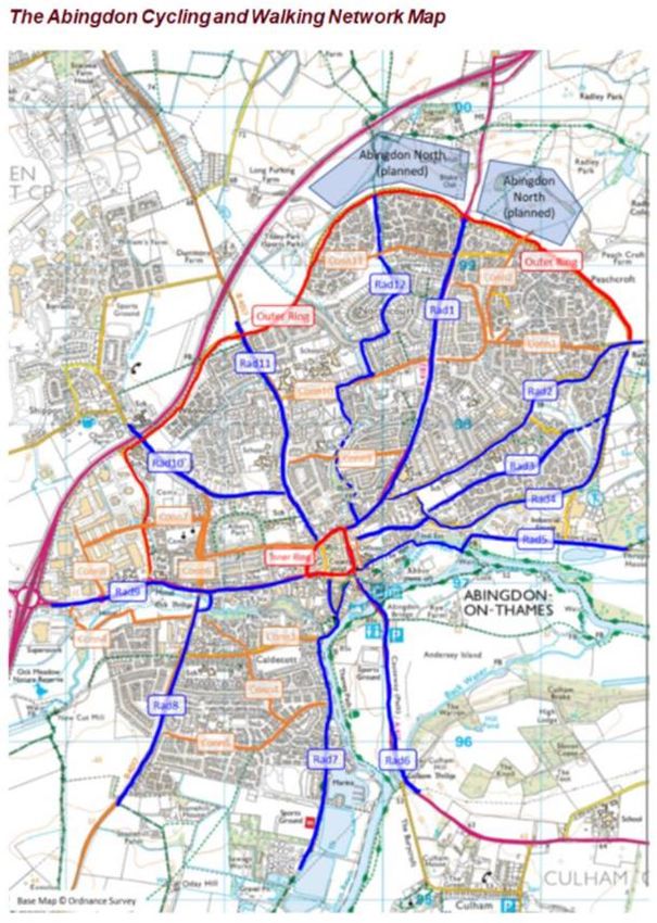
•   Banbury - an enthusiastic and growing group to improve cycling and reduce some of the worst
       air pollution in the county;
   •   Bicester BUG (Bicycle Users Group) - has had to focus on roundabout design, but is ready to
       tackle more active travel issues;
   •   Chipping Norton – planning a new cycle track to link with Kingham station;
   •   Faringdon – developing a cycling plan;
   •   Wantage – pedestrianisation of the Market Place is expanding into work on a Local Cycling and
       Walking Infrastructure Plan.

The outreach has been led by Oxfordshire Liveable Streets, with financial support from the Midlands Co-
op. One important lesson is that there are often several groups in an area that, with a little networking
and prompting, can coalesce into a self-sustaining and pro-active hub. The enthusiasm is often there, but
disparate.

Feasibility of producing a 15 minute neighbourhood tool to understand Walkability in
Oxfordshire

The unique and innovative Walkability Index has been produced by Cyclox through a very useful
collaboration with one of their members, Will Ray – a highly skilled geospatial statistician. This, we hope,
will develop into a useful tool for local authorities to identify where support for active travel is most
needed.

The map of the Walkability Index shows who in Oxford can walk, on existing routes, to five basic
amenities in less than 15 minutes: the core concept behind the 15-minute neighbourhood (15MN). The
measurements are based on walking, though anyone on a bike could get there more quickly. The
information was collated from a range of sources and the basic amenities chosen by the team were:

   •   General practice surgeries (GPs);
   •   Supermarkets;
   •   Schools;
   •   Pubs, and;
   •   Publicly-accessible green spaces.

The resultant map rates streets in terms of their walkability. The index creates a score for proximity of
each amenity and creates an overall score at street level which is plotted on the map to give a
visualisation of those streets and communities close to and further away from basic amenities. Residents
living in less walkable areas are more likely to get into a car, or need a good bus service. The Walkability
Index, therefore, identifies where additional amenities and services need to be provided, so people can
be encouraged to cycle or walk, rather than use the car. This will result in less air pollution and carbon
dioxide emissions.

In a parallel activity, CoHSAT has started to assemble a digital resource that lists the sources and types of
information about travel-related issues generally, such as those used in the Walkability Index. The aim is
to help those wanting to understand the statistics and trends in Oxford and Oxfordshire or produce their
own reports. This is an ongoing project and will help to identify where there are omissions, as well as
where contributory data (eg on obesity and collisions) can be found.

                                                                                                    Page 4 of 23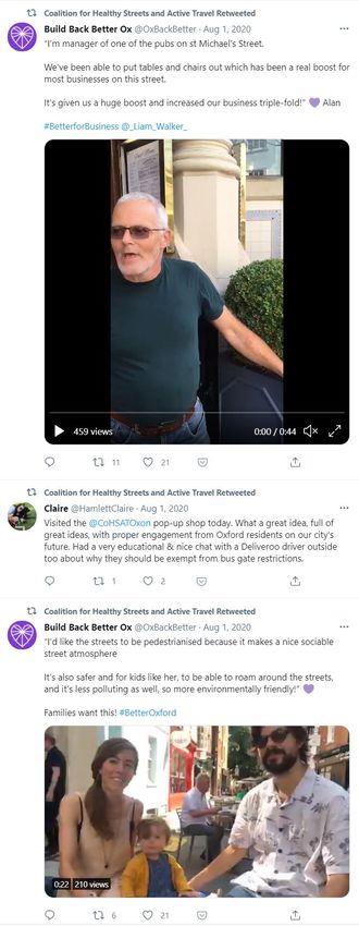
Statistical analysis of travel trends is becoming more important. For instance, the new Local Travel and
Connectivity Plan consultation from Oxfordshire County Council lists several measurable items. These are
often based on what is available, but not necessarily those central to the topic. For instance, there is
nothing mentioned about the length of segregated cycle paths, nor on the width of pavements.

For further information on these five investigations and other CoHSAT activities see
http://www.cohsat.org.uk or email us at info@cohsat.org.uk.

                                                                                               Page 5 of 23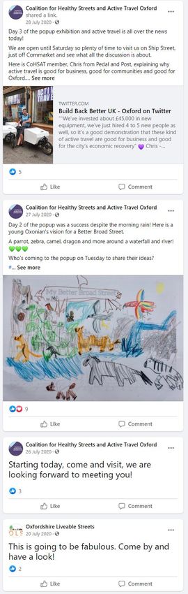
1. The opportunities to convert St Giles into a public space

Context
When Oxfordshire County Council adopted the Oxford Transport Strategy (LTP4)1 in 2016, there were
clear references to the need to redesign St Giles:

             ‘Public realm schemes, which include rationalisation of on-street vehicle parking such as those
            for St Giles and Broad Street, will provide opportunities for increasing cycle parking’(p23);

            ‘There is a need for major improvements to public realm and ‘sense of place’ in the city centre. In
            the short term, the pedestrianisation of George Street and Queen Street, as well as public realm
            improvements to St Giles, Magdalen Street and Frideswide Square will greatly improve the quality
            of public place within the city centre’ (p24);

            ‘consolidation of public parking into fewer locations, predominantly underground (eg new
            Westgate car park), with existing surface car parks redeveloped for other uses and on-street
            parking rationalised as part of public realm improvements (for example, St Giles and Broad Street)
            (p29).

By February 2021, five years later, none of these beneficial, though piecemeal, suggestions for St Giles
had been implemented, despite the precedent set in the City when Cornmarket was pedestrianised and
all traffic removed during the main part of the day.

CoHSAT undertook an extensive re-assessment of St Giles to provide the basis for detailed development
plans. A contributory reason for the remodelling of St Giles is that under the adopted Local Cycling and
Walking Infrastructure Plan (LCWIP) for Oxford, the number of cyclists using Banbury and Woodstock
Roads (and, therefore, often St Giles) will double by 2031. The plans for the redevelopment of Banbury
and Woodstock Roads are being formulated, from the beginning of 2021 with, at least, some strong
implications for the future shape of St Giles.

St Giles is also affected by the Zero Emission Zone’s green plan and by Connecting Oxford’s proposed
busgate/traffic filter in Worcester Street. Both of these will result in less traffic in St Giles.

The site
St Giles is a wide road from the centre of Oxford City leading north to the start of the Banbury and
Woodstock Roads. It is about 350m in length, stretching from the Martyr’s memorial in the south to the
war memorial, St Giles church and graveyard in the north. It has historic buildings on both sides: the east
(St John’s College) and the west (St Cross College, the Taylorian and small businesses). Both sides of the
road contain magnificent plane trees. The road is important for cars, buses, cyclists, pedestrians and
tourist coach parking (at the southern end, outside the Taylorian). 2

At least some of the road is owned by St John’s College and in September, when there is no Covid, there
is the annual 4-day St Giles Fair, when the road is totally closed to traffic.

1
    https://www.oxfordshire.gov.uk/residents/roads-and-transport/connecting-oxfordshire/policy-and-overall-strategy
2
    A satellite view can be found at: https://www.maps-streetview.com/United-Kingdom/Oxford/streets.php?street=ST+GILES%27

                                                                                                                             Page 6 of 23
From the back of the pavements on both sides, St Giles is 63m wide. The majority of the space (Figure 1)
is dedicated to vehicle use, as road (28m, 44%) or parking (23m 37%), with relatively narrow cycle paths
and pavements and a 1m-wide central division

Figure 1: Cross section of St Giles today looking north

There are no bus stops on St Giles nor is there a pedestrian crossing. The one-way Pusey Street enters in
the middle of the west side, but this has limited traffic. There are no other streets joining St Giles. On the
east side at the southern end, there is a walled-off grass and tree area, which is the private property of St
John’s College. It makes the eastern carriageway narrower at that end. The present status of this is not
known – it is not a burial ground, but water-tanks were installed under it during the second world war.

At the southern end on the west side, Beaumont Street feeds traffic into St Giles, together with buses
coming up from Magdalen Street. The City and County Councils are proposing to instal a traffic-filtering
system (aka a bus gate) on Worcester Street. This was due to happen in Autumn 2020, but has been
delayed. When this happens, the traffic travelling between Beaumont Street and St Giles will be limited to
taxis and blue-badge holders and, perhaps, the tourist sightseeing bus. The buses coming up from
Magdalen Street will not be affected. An excellent opportunity to reassess St Giles occurs when the
Worcester Street traffic filter is installed, hopefully some time in 2021, although most of the proposals
below are not dependent on this.

The proposal
Building on the somewhat tentative proposals in the Oxford Transport Strategy, cited above, there is a
real opportunity to reallocate space on St Giles, to reduce the dominance of the car and enhance the
historic and attractive townscape – to return most of St Giles to pedestrians.

With the amount of width there is in St Giles, there are numerous options for how it could be refigured.
As Figure 2 shows, there is ample room for adequate road (two 5m carriageways) and cycle space (two
3m wide segregated lanes). This would enable there to be pedestrianised spaces of 20-25m width on
each side. These would provide wonderful opportunities for imaginative ideas - for cafés, for seating, for
flower kiosks, for sculptures - to make St Giles an even more attractive place to walk, visit and dwell. It
would become a new, tourist destination in our historic city.

Figure 2: Potential vision of St Giles with enhanced public realm: a cross section from West to East, with no parking and reduced
road space. The trees and the central division would stay in the same place as in Figure 1.

                                                                                                                      Page 7 of 23
An illustration of how it could look is given in Figure 3, from Joelle Darby of Original Field. St Giles could
become the place to have a passegiata and enjoy an enhanced public realm.

Figure 3: Space reallocated in St Giles to provide a segregated cycle track, kiosks and sculptures in the old parking area and a
pedestrian crossing. Looking north and west

This remodelling of St Giles could start immediately – the car parking could be removed before the
Worcester Street traffic filter is installed. In the longer term, consideration should be given to a scheme
that puts the people in the centre, literally, and the traffic on the outer edges. This would have the
benefit of a very large central space, providing even more attractions for pedestrian enhancing its
popularity – like Las Ramblas in Barcelona. However, there would be issues if there continues to be two-
way traffic on both Woodstock and Banbury Roads, necessitating some crossing over to get to the edges
of St Giles. There are implications for these more extensive proposals from the imminent plans for
Woodstock and Banbury Roads.

These plans for St Giles were displayed at CoHSAT’s pop-up shop in July 2020. The vast majority of the
comments from the public were supportive, or even ecstatic:

    o    St Giles is so wide and it’s brilliant to see public space reallocated to people not traffic!
    o    Absolutely wonderful! I have longed for this.
    o    Like it – especially moving the tourist buses out (cf Cambridge, Winchester, Bath …)
    o    Yes please! Looks amazing. Thank you.
    o    Segregated cycle lanes – yes!! Essential
    o    St Giles would be so good transformed!
    o    Wonderful.
    o    Don’t forget older and disabled people
    o    More space for people!
    o    San Sebastian has brilliant pedestrian and cycle routes in Spain
    o    Disabled people need to get within 50m of every part of the city (A criteria for a blue badge)
    o    Spot on.
    o    Better to have cars / buses /… in roads to side – with centre free, like Las Ramblas
    o    Great idea!
    o    Yes! We so need it.
                                                                                                                        Page 8 of 23
o    Yes let’s get this motorway-width road made into a beautiful public square.
       o    This is such a great idea and would/could become a real location/spot in Oxford. The trees and
            space that already exist there mean this just makes perfect sense. It’s a no-brainer.
       o    Thank you for getting us all thinking and believing in making Oxford a cycling city.
       o    Love this! St Giles now might be the worst possible use of space in Oxford

International evidence
There are numerous international precedents for making large, central, traffic-dominated spaces into car-
free attractive areas of public realm. The most famous is probably the conversion of Times Square in New
York3. Other examples in Europe have been successful 4 and the precedent was set in Oxford with the
pedestrianizing of Cornmarket.

Summary
There are great opportunities to transform one of the most attractive streets in Oxford – St Giles. It could
become mainly a wonderful pedestrianised area, under the lovely plane trees. Cafés, stalls, planting,
sculptures could all be encouraged and would contribute to reinvigorating the way people use this
central space. This could be achieved without impairing traffic flow, purely be narrowing the traffic lanes
and removing parking. The proposals could be implemented as of now, but will be enhanced when the
Worcester Street bus gate is installed and there is less through traffic.

3
    https://ny.curbed.com/2017/4/19/15358234/times-square-snohetta-before-after-photos
4
    https://ec.europa.eu/environment/pubs/pdf/streets_people.pdf
                                                                                                    Page 9 of 23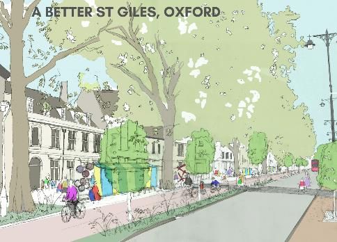
2. Creation of a Popup Experience on projects to improve active travel in Oxford

CoHSAT opened a popup exhibition in the centre of Oxford on projects to improve active travel in
Oxford. This activity replaced the original proposal to look at the mismatch of narrow pavements and
wide roads on certain streets.

There were 14 major initiatives displayed representing options that would improve many areas of Oxford
– not all in the City centre. The idea for a popup shop was supported by the CoHSAT committee and
Simon Pratt and Brenda Boardman (the CoHSAT co-chairs) decided that it was a ‘now or never’ time. The
County Council had to apply for the Government’s Emergency Active Travel Fund (EATF) by 7 August and
we wanted to try and influence their thoughts. The decision was taken to proceed on 26 June 2020 – a
month before the shop opened.

We leased premises in Ship Street, off Cornmarket, from Jesus College, for two weeks for a peppercorn
rent, though the electricity bill cost £200. The shop was perfect for us, as it was clean, did not smell, had a
lot of shelves, excellent lighting and carpeting. We had very limited access prior to opening.
All the material for the exhibition was assembled on Slack, which proved to be an excellent portal, with a
channel for each project. Once we started gathering information, the ideas and suggestions just rolled in.
Virtually none of the material that was eventually used in the shop existed in a format that was suitable
for public display beforehand. We were joined by several enthusiasts from groups like Build Oxford Back
Better and XR. Some of whom just wanted ‘pretty pictures’ whereas in CoHSAT we were determined to
get as much realism as possible, eg emergency vehicles could still access colleges.

Much of the success of the shop resulted from the extraordinary and inspiring illustrations provided by
Andy Coram, a professional photoshop artist, and Joelle Darby of Original Field, a landscape specialist
who did the sketches. Other items were discovered, such as Kathy Shock’s beautiful plan for Broad Street,
the Rose Hill petition on Iffley Road (for quotes) and XR’s large words from their busgates
demonstration.
Major practical and artistic support was also provided by Stig, Zuhura Plummer and Charlie Hicks,
together with CoHSAT members.

CoHSAT’s then project manager, Abena Poku-Awuah, has her own company - Legacy Events Group Ltd.
LCON gave Abena and Legacy a contract, to show she was employed and to clarify the responsibilities.
Legacy then added the popup shop to their public liability insurance, signed the lease with Jesus College
and took responsibility for health and safety. We could not have done it without Abena’s generosity over
the bureaucracy and her unstinting support.

The main cost, of nearly £600, was the printing of 120 posters and 350 postcards. Funding was provided
by this Low Carbon Hub Large Grant 2020, together with donations from three other CoHSAT members.
Early on we confirmed the week of 26 July – 1 August as the latest that we could influence the County
Council’s EATF thoughts. It was a lot of work to get high resolution images of everything, and to clearly
state for the printers what we wanted, to what size, portrait or landscape. These specifications required a
fairly detailed layout plan of how to mount the exhibition in the shop. Everything was taken to the
printers on Monday 20 July. We used Minuteman Press and were very pleased with their standards. They
sent me proofs electronically before printing, which helped.

We opened from 10-4 for each of the 7 days and had roughly equal numbers of visitors. Getting
volunteers was not as easy as expected (3 pairs x 2 hours each) and we certainly benefitted from some
helpful XR people. All personnel were expected (by the visitors) to be well informed about a wide range

                                                                                                    Page 10 of 23
of travel-related issues. This was rarely possible, but often there were other visitors that could help with
debates.
With Abena’s help, we got a press release out to the media, together with tweets co-ordinated by Charlie
Hicks of Build Oxford Back Better. We got coverage on BBC local tv and radio, Jack FM, the front page of
the Oxford Mail and a mention in the Oxford Times.
We had 360 visitors and took about 50 individually written postcards to county councillors. Over 90% of
the visitors were people who were already interested, very few were passers-by from Cornmarket. We
were, therefore, dealing with the semi-knowledgeable, who often had real concerns, good questions: eg
‘What is a busgate’. The popup shop was primarily a public information and awareness exercise. By and
large, the supportive people are doing so from an Oxford perspective, whereas those with worries are
usually concerned about the impact on them as individuals.
The most support was given to our ideas for:
• Broad Street
• St Giles
• Hythe Bridge Street
• Iffley Road
• Low Traffic Neighbourhoods (LTNs) – with several requests for new areas, e.g. Marston,
Wolvercote, Kennington, Littlemore, New Hinksey
There was little support for:
• Cowley Road (if 1-way)
• High Street, ditto
Busgates were the focus of considerable debate. Over half our visitors were supportive and many of the
remainder were happy to have accurate information and to enter into reasoned discussions.
The materials from the exhibition can be viewed online on the CoHSAT website at
http://cohsat.org.uk/popup. A video gathering perspectives of people visiting the exhibition and on the
streets of Oxford was produced by Jack Bradley and can be seen at the same link. We have not put up
the exhibition anywhere else, though there were some groups initially interested. The majority of the
material has not dated and is still relevant, so could be displayed again.
CoHSAT are extremely glad to have done the popup shop, though it was a non-trivial activity. It made us
firm up on a lot of ideas and has definitely resulted in progressing the debate. We were particularly
delighted at the enthusiasm and support shown by our visitors and hope that both Oxfordshire County
council and Oxford City Council realize there is a groundswell of public opinion that wants to see the City
reinvigorated with wonderful, new public realm and active travel facilities.
For further information on our five 2020-2021 projects and other CoHSAT activities see
http://www.cohsat.org.uk or email us at CoHSATOxon@gmail.com.
Page 11 of 23Page 12 of 23
Social media activity about the Popup Experience on the CoHSAT Facebook and Twitter accounts

                                                                                          Page 13 of 23
3. Advice Guide - The provision of good quality, on-road cycle parking where
none exists at present
What is a bike hangar?
A bike hangar provides secure, covered storage for bikes for an annual fee, usually in groups
of six. The hangar is on-street or in an accessible, unused space, perhaps created when a
traffic filter is introduced as in the photo.
The cover is unlocked by the renter, with a key, and opens up so the bike can be installed
inside, before shutting and locking the cover. Even if it has a small trailer, the bike can fit in.
The bike hangar is likely to last several years. The bike hangar is about 2.5m long, the length
of half a car.
When are they most useful?
Many areas have housing which makes it difficult or impossible to store bicycles within their
boundaries. This leads to bikes being locked next to properties on pavements and causing
obstructions to pedestrians, people with child buggies or those using disability scooters and
wheelchairs. Opportunities exist where there are:
• terraced streets with no or small front gardens and no side/rear access;
• flats;
• properties with no suitable area for storage inside the house;
• areas with particularly narrow pavements;
• where there is a high proportion of households using bikes, not cars.
In addition, bikes are less secure when not locked to a structure and more vulnerable to
theft. This is becoming more important with valuable electric bikes. The police in Oxford are
concerned about the high level of cycle thefts and treat it as a priority.
Who provides the bike hangar?
Page 14 of 23The main commercial company is Cyclehoops and they will provide and install the bike
hangar for about £3150 (+VAT) in Oxford. The price is dependent on how many are installed
at one go, with savings if there are several.
Each individual bike-owner rents a space, that is specific to them, from Cyclehoops. This
costs £72 a year currently for each cycle space, less if there is a subsidy. This yearly rental
covers the cost for a twice yearly maintenance of the hanger to make sure the pneumatic
opening is working and other elements are safe (this could be outsourced to a local group or
business).
How to proceed?
There are several things to do prior to discussions with the residents, to ensure that the
proposal is workable, without raising false expectations.
• Discuss with the local highways authority (the County Council) and the planners (the
District Council) their attitudes to bike hangars. This combines well with discussions
about Controlled Parking Zones as it is easy to allocate space at this point;
• Discuss with the local councillors to gauge their support;
• Get a short-list of appropriate streets, to confirm with the councils and for a Cyclehoops
representative to visit and assess the options.
A site will not be suitable if it is:
• Too close to a corner;
• Covering drains or blocking entrances;
• Adjacent to street furniture or lights;
• Very sloping, in any direction;
• Might be affected by tree roots;
• In an area with a high proportion of students or low-income households who are unlikely
to want to pay for storage;
• In a street where everyone has a car and there is already considerable pressure on
parking spaces (and there would be a lot of opposition), unless there is a nearby space
(as in the photo above) that cannot be used for car parking. There is a need to discuss
use of road space for all users.
• Too far from likely bike users (50 metres recommended).
Next steps
Working on a strategy to implement the introduction of covered bike hangers is an
important aspect; normally a straightforward approach of public consultation, below, would
seem to be reasonable. However, experience from London Boroughs suggests this may raise
objections before any real consideration of the issues is made. This appears to be predicated
on the notion that cars can dominate roads and car parking is the central issue for use of
space. An alternative approach may be to make a proposal with all the possible elements in
place and then consult.
Arrange a public meeting, attended by the local councillors and council staff, and leaflet the
households in the street to invite them about it. This meeting might be arranged by a local
community group or by the council representatives themselves.
Page 15 of 23Have a speaker at the meeting who can address the issues of air pollution and congestion
from cars and the need to switch to more active travel in general.
Have a speaker from the council who can reiterate council policies towards reducing carbon
emissions in the immediate future and the role of transforming the way we travel as part of
that policy. The council may want to subsidise the first few bike hangars, in order to get the
concept adopted. Experience from the London Boroughs is that demand increases
dramatically, once a few successful bike hangars have been introduced.
Try and make sure there are representatives of the disabled, pedestrians, parents of young
children in the room. There will be opposition from the existing residents who own cars if
parking places are to be lost, but they are not the only groups to be considered.
It may be sensible to have a public meeting that covers several roads where bike hangars are
proposed, to make good use of the speakers’ time. This will also be important as gaining
revision of planning rules costs about £2000 for a single or number of sites, which makes
smaller proposals less financially viable.
The council may take the decision to instal some bike hangars, at their own cost, regardless
of any apparent opposition. In which case, the local environmental groups can help drum up
support from likely users. It is anticipated that some people will become cyclists, now that
there is secure storage available, and some others will switch from a pedal to an electric bike.
Given the problems of local funding in the recovery stage following Covid-19 it may also be
helpful to gain support for finance from organisations and businesses supporting carbon
reduction in areas, especially to support their employees cycling to work.
A further strategy may be to begin a campaign to raise the issue of the dominance of cars in
road space use, before introducing statistics on possible use. Cyclehoops would be willing to
be involved in collecting requests for the use of cycle hangers in streets and areas, as they do
in London, at no local expense.
Page 16 of 234. Assisting the development of new Healthy Streets and Active Travel groups
in several market towns
Context
CoHSAT wants to help develop initiatives in the other major towns in Oxfordshire and in the
original proposal planned to stimulate activity by holding public meetings either (a) where a
Local Cycling and Walking Infrastructure Plan (LCWIP) has been produced (Didcot, Bicester,
as well as Oxford) or (b) where a need has been identified. For instance in Abingdon,
monitoring local pollution levels is already underway, together with a survey to establish
whether residents want to close Northcourt Road to through traffic.
Abingdon will be the initial focus, in conjunction with Abingdon Carbon Cutters. Other likely
market towns have already been identified by OCN and OLS, as there is an active group or
keen individuals, which would appreciate some extra support, to establish a new community
group. The development of new groups will make it easier to press the County Council to
take more action, for instance with the Local Transport and Connectivity Plan 5 (LTCP5). OLS
has a grant of £1,950 from the Midcounties Co-op Community Fund for this activity and will
contribute this as matched funds for the CoHSAT bid.
The original intention was to hold a series of face-to-face meetings in each of the towns to
establish the level of interest. This would be followed up with a workshop to co-design the
broad principles of traffic management and street design, with stakeholders including
Councillors.
Sadly Covid-19 put paid to these ambitions, but we have made surprisingly good progress
through the medium of virtual meetings and we are pleased to report on activity in several
towns across the County.
Policy background
Local Cycling and Walking Infrastructure Plans (LCWIP) are increasingly seen as the way into
Government funding and are already influencing funding allocations to local authorities. In
Oxfordshire, the County Council has completed LCWIPs in Oxford and Bicester. A plan for
Didcot is in development, with others under consideration for Kidlington and Abingdon.
The Government published Gear Change: A bold vision for cycling and walking in July 2020,
with the stated ambition that: “Places will be truly walkable. A travel revolution in our streets,
towns and communities will have made cycling a mass form of transit. Cycling and walking
will be the natural first choice for many journeys with half of all journeys in towns and cities
being cycled or walked by 2030.”
The document confirmed: “The £2bn of funding for cycling and walking that the Government
announced in May 2020 is new money, representing a sixfold increase in dedicated cycling
and walking funding.” It was accompanied by new cycling design guidance which sets out
the much higher standards they will now require if schemes are to receive funding.
Page 17 of 23Abingdon
CoHSAT convened a meeting largely drawn from members of Abibike and Abingdon Carbon
Cutters in May 2020. This led to the formation of a working group that surveyed and
designed a comprehensive walking and cycling network for the town, published in
September 2020 [link]. The Abingdon Cycling and Walking Network Plan was developed by
Abingdon Liveable Streets, a collaborative, community-based group which includes members
of Abibike, Abingdon Carbon Cutters, Abingdon Freewheeling, Abingdon Health Walks and
the Town Council. The plan is being actively considered by the County Council, with a view to
including it in their LCWIP programme.
Wantage
Wantage Active Travel – a new group, started to form in 2020 and gathered momentum in
the first lockdown. The first projects were supporting partial pedestrianisation of Market
Place and input to the County Council’s Emergency Active Travel Fund bid (latter via
CoHSAT). They have since been adding members to the interest group and having
discussions via Zoom. They are now planning an online meeting on 17th Feb 2021 to kick off
the next phase, which is to develop a walking and cycling plan – a ‘Community LCWIP’ for
the town.
Chipping Norton
A few people got in contact with CoHSAT during 2020 and we put them in touch with each
other, and gave them advice about how to proceed. They are now starting to consider
developing a plan for a town LCWIP and a walking and cycling route to Kingham station,
largely following the line of the old railway.
Bicester
Bicester Bicycle Users Group (BUG) formed in 2019. CoHSAT has been advising them
through the year while they developed and responded to road and housing developments.
There is a particular issue with a high speed roundabout that we helped them raise to
County Cabinet Member level (although the design has been improved it has not been
changed from a high-speed design to a more appropriate compact design).
Faringdon
Mark Harrison, Chair of Farcycles is now leading a team to develop a walking and cycling
plan for Faringdon. He has also volunteered to be a Cycling UK Regional Coordinator for the
Cycle Advocacy Network.
Banbury
A number of individuals and groups contacted CoHSAT members during 2020 and they were
eventually brought together for a meeting organised by Banbury Community Action Group
(CAG) in January 2021. The engagement on the day and subsequent feedback was very
positive:
Page 18 of 23“The Banbury CAG cycling initiative group is most appreciative of all the suggestions,
advice, support and encouragement you sent our way. We will reflect on your
suggestions and build on what we learnt last night, to take the project forward. We
appreciate that even the 'quick wins' might be somewhat slow, but hopefully our
enthusiasm and that of many other Banbury residents, will eventually produce results,
and cycling will eventually be a safer, more pleasant, and therefore more common
means of transport in the town.”
At the meeting, CoHSAT members stressed the importance of the following, based on our
learning in Oxford:
1. Involvement and support of local Councillors is vital
2. A broad coalition of groups is important, particularly in a town like Banbury where
levels of cycling are relatively low
3. While a network plan for the town is the ultimate ambition, advocating for practical
measures that make a real difference is a good starting point
See the Figure 1 map below of the Abingdon LCWIP.
Figure 1: Map of Abingdon LCWIP
Page 19 of 235. Feasibility of producing a 15 minute neighbourhood tool to understand
Walkability in Oxfordshire
1. What is a 15-minute-neighbourhood?
Over the last few decades, people have made fewer and fewer journeys on foot or by bike as
services and amenities have become dispersed and located in places only accessible by car.
Local neighbourhoods should be places where people should be able to meet and connect
with others. They should be places where it is possible to linger and enjoy being in the open
air, places that can be reached without having to get into a car, places you can get to for
most of your daily needs and where your workplace is.
What does this mean for local communities? It means being able to access amenities such as
supermarkets, cafés, pubs, green spaces, schools, pharmacies, all within a 15-minute walk
there and a 15-minute walk back. It means that there needs to be workplace spaces within
communities rather than in business parks in the periphery. It means neighbourhoods need
to be more compact rather than a sprawl.
The Coalition for Healthy Streets and Active Travel have begun to promote the concept with
a view creating a major campaign to change policy and practice of our councils, and of
developers, and stop the current trend of building in car dependency into the everyday lives
of so many people. This will mean finding ways through policy change of encouraging local
amenities, moving away from out-of-town retail parks and supermarkets, and changing
transport planning to enable more people to walk, cycle and take public transport.
The kinds of policy changes needed to create 15-minute-neighbourhoods are:
• Creating affordable homes and diversity in housing development, which are suitable
for people at different life stages;
• Bringing in jobs and services into local areas through incentivising inward investment
into communities and discouraging out of town developments;
• Maximising use of local community buildings such as schools so they can be used for
a range of activities 24/7;
• Creating safer local communities that get people out of cars, through the creation of
Low Traffic Neighbourhoods, low emission zones, home zones, cycle streets, and
removing through traffic;
• Adopting 15-minute-neighbourhood as a key principle in local plans and in local
transport strategies.
All this of course depends on creating a planning system that makes sustainable
neighbourhoods the obvious solution.
Page 20 of 232. A Walkability Index for Oxford
One of the first activities we have done in CoHSAT is to create a Walkability Index. A
member of Cyclox, Will Ray, who is a geographer and spatial mapper worked with CoHSAT
on creating an index, using proximity to supermarkets, green space (parks, playing fields and
allotments), pubs, schools and GP surgeries.
Will produced the following map rating streets in terms of their walkability. (For technical
details behind the creation of this map see the appendix.)
From this map you can see that the most walkable areas in the city are near district centres,
Summertown, Jericho, Cowley Road, Temple Cowley, Headington. The areas with the least
Page 21 of 23workable areas tend to be in the peripheries of the city, and several are in the more deprived
parts of the city, Blackbird Leys, Cowley and Barton. The lack of local amenities probably
contributes to making these places less desirable to live in and locking in car dependency in
those communities that can least afford a car.
3. Next steps
The concept of a 15-minute neighbourhood (15MN) is that the amenities that are most
important to you are within a 15-minute walk of your home. This is an idea in development
and there is little evidence of what constitutes the ‘most important amenities’ for people in
different localities.
CoHSAT will devise a questionnaire asking people to identify the amenities that matter most
to them, and those that are important, but less vital. We anticipate that the responses will
vary according to the size of the development people live in, ranging from Oxford to small
villages in Oxfordshire.
The results will help to inform policy and assist in initiatives that make it more possible for
basic amenities to be taken to people, rather than expecting people to travel to them,
whether by car or expensive (and infrequent) bus. The effect would be a stronger community
and less polluting car travel.
Appendix. Technical details of the creation of the Walkability Index for
Oxford
Quantifying walkability is extremely difficult, but one aspect the accessibility of local
amenities is one way that you can measure how feasible it is to walk around your local
neighbourhood during your everyday activities. A lot of this data is widely available and has
been used in this project. Open Street Map was used to create a “network” to perform the
analysis on including roads, local footpaths and rights of way. To produce a more accurate
representation of where you can walk, dual carriageways and motorways were removed from
the network (in Oxford this was just the ring road which you can’t walk on anyway).
Amenities data was collected from open street map too using the Overpass API. Schools, GP
surgeries and Pubs were collected from this source. Other amenities like dentists, nurseries
and coffee shops are also available but were not used in this version of the index. A filtered
Ordnance Survey product called Open Map Greenspace was also used to model access to
open space. The point dataset of access points was used rather than the greenspace polygon
product. Lastly, the free to use Geolytix Retail Points dataset was used to locate
supermarkets in Oxford.
Firstly, an isoarea analysis was conducted on each the individual datasets producing a raster
result with distances to the different classes of amenities. Distance rather than time was used
as the unit of measurement and a walking speed of 4.5km/hr was used as the default walking
speed. This is the same speed as used by Google in their navigation applications. The raw
rasters were then binned into 5 classes; 0-500m, 500-1000m, 1000-1500m, 1500-2000m and
Page 22 of 232000m+. Each of these classes were allocated a score of 1 to 5, with 1 being the closest and
5 for the areas furthest away.
The above was repeated for all five inputs and combined into an overall score. This
contained scores of 5-25 as there were five inputs into the model. This was then split into 5
classes.
Score Label Definition
5 Extremely Walkable All amenities are within a 500m walk
6-7 Very Walkable Most amenities are within 500m walking
distance but some are further away.
8-10 Walkable All amenities are within 1km walking distance.
11-15 Just about Amenities will be around 1km away, some
Walkable maybe further away.
16-21 Not very Walkable Almost all amenities are will be 1-1.5km walk
away or further.
22-25 Unwalkable Most amenities are over 2km walk away.
Further improvements
• Weightings could be used
• Other inputs like coffee shops and nurseries, pharmacies
• Missing OSM data
• Access to public transport
• Tweaking of the class boundaries.
https://www.ordnancesurvey.co.uk/business-government/products/open-map-greenspace
https://www.geolytix.co.uk/#geodata
Page 23 of 23You can also read