Committee Report Business Item No. 2020-2 JT
←
→
Page content transcription
If your browser does not render page correctly, please read the page content below
Committee Report
                                                                       Business Item No. 2020-2 JT

Community Development Committee
Meeting date: January 6, 2020

Environment Committee
Meeting date: January 14, 2020

For the Metropolitan Council meeting of January 22, 2020

Subject: City of Waconia 2040 Comprehensive Plan and Comprehensive Sewer Plan, Review File
22018-1
Proposed Action
That the Metropolitan Council adopt the attached Advisory Comments and Review Record and take the
following actions:

Recommendations of the Community Development Committee
   1. Authorize the City of Waconia to put into effect the portion of its 2040 Comprehensive Plan
      pertaining to areas within the City’s boundaries as of November 19, 2019, and those portions of
      Laketown Township for which the City has existing Orderly Annexation Agreement (OAA).
   2. Advise the City of Waconia that the Council has reviewed the remainder of the Plan and has
      found no regional system conformance or policy consistency issues at this time. Because the
      City does not have the legal authority to plan and zone for areas within Waconia Township in
      the absence of an OAA, the City may not put those portions of the Plan into effect at this time.
      At such time as the City of Waconia acquires jurisdiction of the lands planned for future
      urbanization in Waconia Township either through an Orderly Annexation Agreement or
      annexation by ordinance, the City will need to submit appropriate plan amendments to the
      Council for further review and action.
   3. Advise the City to implement the advisory comments in the Review Record for Surface Water
      Management, Land use, and Water Supply.

Recommendation of the Environment Committee
   1. Approve the City of Waconia’s Comprehensive Sewer Plan.

Summary of Community Development Committee Discussion/Questions
Senior Planner, Raya Esmaeili, presented the staff’s report to the Committee. No representatives from
the City of Waconia were in attendance.

The Community Development Committee unanimously recommended approval of the proposed action
with no questions or discussion at its meeting on January 6, 2020.
Summary of Environment Committee Discussion/Questions
No comments or questions. The Environment Committee approved the proposed action on its consent
agenda at the January 14, 2020 meeting.

Page - 1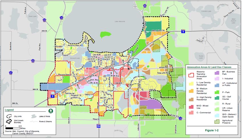
Joint Business Item No. 2020-2

Community Development Committee
Meeting date: January 6, 2020

Environment Committee
Meeting date: January 14, 2020

For the Metropolitan Council meeting of January 22, 2020

Subject: City of Waconia 2040 Comprehensive Plan and Comprehensive Sewer Plan, Review File
22018-1
District(s), Member(s): District 4, Deb Barber
Policy/Legal Reference: Metropolitan Land Planning Act (Minn. Stat. § 473.175), Minn. Stat. §
473.513
Staff Prepared/Presented: Raya Esmaeili, Senior Planner (651-602-1616)
                          Angela R. Torres, Local Planning Assistance Manager (651-602-1566)
                          Kyle Colvin, Engineering Programs, Manager (651-602-1151)
Division/Department:              Community Development / Regional Planning
                                  Environmental Services / Technical Services
Proposed Action
That the Metropolitan Council adopt the attached Advisory Comments and Review Record and take the
following actions:

Recommendations of the Community Development Committee
   1. Authorize the City of Waconia to put into effect the portion of its 2040 Comprehensive Plan
      pertaining to areas within the City’s boundaries as of November 19, 2019, and those portions of
      Laketown Township for which the City has existing Orderly Annexation Agreement (OAA).
   2. Advise the City of Waconia that the Council has reviewed the remainder of the Plan and has
      found no regional system conformance or policy consistency issues at this time. Because the
      City does not have the legal authority to plan and zone for areas within Waconia Township in
      the absence of an OAA, the City may not put those portions of the Plan into effect at this time.
      At such time as the City of Waconia acquires jurisdiction of the lands planned for future
      urbanization in Waconia Township either through an Orderly Annexation Agreement or
      annexation by ordinance, the City will need to submit appropriate plan amendments to the
      Council for further review and action.
   3. Advise the City to implement the advisory comments in the Review Record for Surface Water
      Management, Land use, and Water Supply.

Recommendation of the Environment Committee
   1. Approve the City of Waconia’s Comprehensive Sewer Plan.

Page - 2 | METROPOLITAN COUNCIL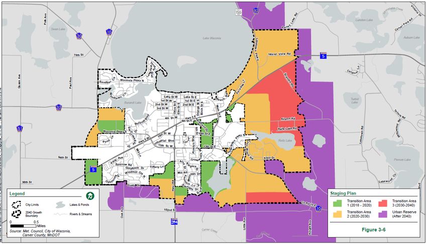
Advisory Comments
The following Advisory Comments are part of the Council action authorizing the City of Waconia to
implement its 2040 Comprehensive Plan (Plan).

Community Development Committee
   1. As stated in the Local Planning Handbook, the City must take the following steps:
          a. Adopt the Plan in final form after considering the Council’s review recommendations as
              contained in the body of this report.
          b. Submit one hard copy and one electronic copy of the Plan to the Council. The electronic
              copy must be submitted as one unified file.
          c. Submit to the Council a copy of the City Council resolution evidencing final adoption of
              the Plan.
   2. The Local Planning Handbook also states that local governments must formally adopt their
      comprehensive plans within nine months after the Council’s final action. If the Council has
      recommended changes to the Plan, local governments should incorporate those recommended
      changes into the Plan or respond to the Council before “final adoption” of the comprehensive
      plan by the governing body of the local governmental unit. (Minn. Stat. § 473.858, subd. 3)
   3. Local governments must adopt official controls as identified in their 2040 comprehensive plans
      and must submit copies of the official controls to the Council within 30 days after the official
      controls are adopted. (Minn. Stat. § 473.865, subd. 1)
   4. Local governmental units cannot adopt any official controls or fiscal devices that conflict with
      their comprehensive plans or which permit activities in conflict with the Council’s metropolitan
      system plans (Minn. Stats. §§ 473.864, subd. 2; 473.865, subd. 2). If official controls conflict
      with comprehensive plans, the official controls must be amended within 9 months following
      amendments to comprehensive plans (Minn. Stat. § 473.865, subd. 3).
Environment Committee
    1. The Council-approved Comprehensive Sewer Plan becomes effective only after the Plan
       receives final approval from the local governmental unit’s governing body. After the Plan
       receives final approval from the City and the Comprehensive Sewer Plan becomes effective,
       the City may implement its Plan to alter, expand, or improve its sewage disposal system
       consistent with the Council-approved Comprehensive Sewer Plan.
    2. A copy of the City Council resolution adopting its 2040 comprehensive plan, including its
       Comprehensive Sewer Plan, must be submitted to the Council.

Page - 3 | METROPOLITAN COUNCIL
Background
The City of Waconia is located in central Carver County. It is surrounded by the townships of Laketown
and Waconia.

The City submitted its 2040 Comprehensive Plan (Plan) to the Council for review to meet the
Metropolitan Land Planning Act requirements (Minn. Stat. §§ 473.851 to 473.871) and the Council’s
2015 System Statement requirements.

Review Authority & Rationale
Minn. Stat. § 473.175 directs the Metropolitan Council to review a local government’s comprehensive
plan and provide a written statement to the local government regarding the Plan’s:

   •   Conformance with metropolitan system plans
   •   Consistency with the adopted plans and policies of the Council
   •   Compatibility with the plans of adjacent governmental units and plans of affected special
       districts and school districts

By resolution, the Council may require a local government to modify its comprehensive plan if the
Council determines that “the plan is more likely than not to have a substantial impact on or contain a
substantial departure from metropolitan system plans” (Minn. Stat. § 473.175, subd. 1).

Each local government unit shall adopt a policy plan for the collection, treatment, and disposal of
sewage for which the local government unit is responsible, coordinated with the Metropolitan Council's
plan, and may revise the same as often as it deems necessary (Minn. Stat. § 473.513).

The attached Review Record details the Council’s assessment of the Plan’s conformance, consistency,
and compatibility, and is summarized below.

 Review Standard                    Review Area                                    Plan Status
 Conformance                        Regional system plan for Parks                 Conforms
 Conformance                        Regional system plan for Transportation,       Conforms
                                    including Aviation
 Conformance                        Water Resources (Wastewater Services           Conforms
                                    and Surface Water Management)
 Consistency with Council Policy    Thrive MSP 2040 and Land Use                   Consistent
 Consistency with Council Policy    Forecasts                                      Consistent
 Consistency with Council Policy    2040 Housing Policy Plan                       Consistent
 Consistency with Council Policy    Water Supply                                   Consistent
 Consistency with Council Policy    Community and Subsurface Sewage                Consistent
                                    Treatment Systems (SSTS)
 Compatibility                      Compatible with the plans of adjacent and      Compatible
                                    affected governmental districts
Thrive Lens Analysis
The proposed 2040 comprehensive plan is reviewed against the land use policies in Thrive MSP 2040.
To achieve the outcomes identified in Thrive, the metropolitan development guide defines the Land Use
Policy for the region and includes strategies for local governments and the Council to implement. These
policies and strategies are interrelated and, taken together, serve to achieve the outcomes identified in
Thrive.

Funding
The Metropolitan Council awarded the City a Planning Assistance Grant of $32,000 to complete its
2040 comprehensive plan. The first half of this grant was paid to initiate the local planning process. The

Page - 4 | METROPOLITAN COUNCIL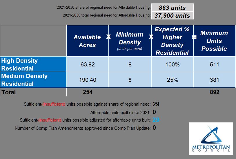
second half of the grant will be paid after Council authorization of the City’s plan, local adoption, and
the City’s submittal of final reporting requirements.

Known Support / Opposition
There is no known local opposition to the 2040 comprehensive plan.

Page - 5 | METROPOLITAN COUNCIL
REVIEW RECORD
City of Waconia 2040 Comprehensive Plan

Review File No. 22018-1, Business Item No. 2020-2 JT

The following Review Record documents how the proposed Plan meets the requirements of the
Metropolitan Land Planning Act and conforms to regional system plans, is consistent with regional
policies, and is compatible with the plans of adjacent and affected jurisdictions.

Conformance with Regional Systems
The Council reviews plans to determine conformance with metropolitan system plans. The Council has
reviewed the City’s Plan and finds that it conforms to the Council’s regional system plans for Regional
Parks, Transportation (including Aviation), and Water Resources.

Regional Parks and Trails
Reviewer: Colin Kelly, Community Development (CD) - Regional Parks (651-602-1361)
The Plan conforms to the 2040 Regional Parks Policy Plan (RPPP) for the Regional Parks System
element. Carver County is the Park implementing agency for the Regional Parks System components
in the City of Waconia, for which the Plan accurately describes the Regional Parks System
components. Regional Trails located within the City include the Lake Waconia-Carver and County Road
10 regional trail search corridors (Figure 1). There are no State or Federal recreation lands within the
City.

Regional Transportation, Transit, and Aviation
Reviewer: Russ Owen, Metropolitan Transportation Services (MTS) (651-602-1724)
The Plan conforms to the 2040 Transportation Policy Plan (TPP). adopted in 2015. It accurately reflects
transportation system components of the TPP as well as applicable land use policies for regional
transitways. The Plan is also consistent with Council policies regarding community roles, the needs of
non-automobile transportation, access to job concentrations, and the needs of freight. The Plan is
compatible with the plans of adjacent and affected governmental units, including the City of Victoria and
Carver County.

Roadways
The Plan conforms to the Highways system element of the TPP. The Plan accurately accounts for the
metropolitan highway system of principal arterials, of which there are none in Waconia. It also
discusses any right-of-way preservation needs.

The Plan accurately reflects the regional functional classification map of A-minor arterials and has
delineated major and minor collectors.

The Plan identifies all the required characteristics of the community’s roadways, including existing and
future functional class, right-of-way preservation needs, and existing and forecasted traffic volumes for
principal and A-minor arterials. Forecasting was done consistent with regional methodology. The Plan
also includes guidelines on how access will be managed for principal and A-minor arterials.

The Plan identifies roadway and corridor studies that include recommendations regarding alignments,
changes in access, and/or changes in land use. They include the TH 5 Corridor Study (2008), the
Carver County Roadway Safety Plan (2013) and the downtown Master Plan
(2014).

Page - 0
Transit
The Plan conforms to the Transit system element of the TPP. It shows the location of existing transit
routes and facilities and acknowledges the City is within Transit Market Areas IV and is a Freestanding
Town Center.

The Plan is consistent with the policies of the Transit system element of the TPP. The Plan addresses
community roles related to its Community Designations, as well as the opportunities and challenges
related to its Transit Market Areas.

Aviation
The Plan conforms to Aviation system element of the TPP. The Plan includes policies that protect
regional airspace from obstructions, addresses seaplane use.

Bicycling and Walking
The Plan is consistent with the Bicycling and Pedestrian chapter of the TPP. The Plan identifies existing
and future segments of, and connections to, the Regional Bicycle Transportation Network (RBTN) and
regional trails. The Plan identifies the Tier 1 corridor on TH 5 and the Tier 2 corridor extending
southeast towards Chaska.

The Plan is also consistent with Bicycle and Pedestrian policies of the TPP by planning for local
pedestrian and bicycle connections to transit, regional trails, regional job concentrations, and other
regional destinations as identified on the RBTN map.

Freight
The Plan is consistent with Freight policies of the TPP. The Plan identifies the needs of freight
movement in and through the community, including accessibility to freight terminals and facilities.
These specific needs include the Tier 3 freight corridor on TH 5 and CSAH 10, that provides
connectivity to the Tier 1 network on Highway 212.

Transportation Analysis Zones (TAZs)
The Plan conforms to the TPP regarding TAZ allocations. The City’s TAZ allocations for employment,
households and population appropriately sum to the Metropolitan Council’s citywide forecast totals for
all forecast years.

The City’s planned land uses and areas identified for development and redevelopment can
accommodate the TAZ forecasted allocations in the Plan, and at densities consistent with the
community’s Thrive designation and applicable TPP policies.

Water Resources
Wastewater Service
Reviewer: Kyle Colvin, Environmental Services (ES) – Engineering Programs (651-602-1151)
The Plan conforms to the 2040 Water Resources Policy Plan (WRPP). It represents the City’s guide for
future growth and development through 2040. It also includes growth forecasts that are consistent with
the Council’s forecasts for population, households, and employment.

Current wastewater treatment services are provided to the City by the Metropolitan Council
Environmental Services (MCES). All wastewater generated within the City is conveyed through Council
Interceptors 8083 and 9204. All flow is treated at the Council’s Blue Lake Wastewater Treatment Plant
in Shakopee. The Plan projects that the City will have 9,500 sewered households and 10,200 sewered
employees by 2040. The Metropolitan Disposal System with its scheduled improvements has or will
have adequate capacity to serve the City’s growth forecasts.

Page - 1 | METROPOLITAN COUNCIL
The Plan provides sanitary flow projections in 10-year increments. The rationale for the projections is
given in the Plan and determined appropriate for planning local services. The Council is committing to
provide the level of wastewater service based on the sewered forecasts as stated in the sewer element
of the Plan.

The Land Use Plan reflects an overall minimum residential sewered density that is consistent with
Council policy for future sewered residential growth for Emerging Suburban Edge communities.

The Plan defines the City’s goals, policies, and strategies for preventing and reducing excessive inflow
and infiltration (I/I) in the local municipal (City) and private sanitary sewer collection systems. The Plan
includes a summary of activities and programs intended to mitigate I/I in both the public and private
property systems, including work related to sanitary sewer pipe lining, maintenance hole structure
repair and replacement, and pipe replacement. Some of these activities are included in the City’s on-
going street reconstruction program. The City also has a private property inspection and repair
program.

The Plan describes the requirements and standards for minimizing I/I and includes a copy of City
Ordinance, Section 403, that prohibits the discharge of any uncontaminated stormwater or groundwater
to the sanitary sewer system through roof drains, sump pumps, footing drain tiles, or swimming pools.
The Ordinance also includes the ability for the City to require inspections of private property for
conformance and require the disconnection of such discharges if discovered.

The Plan describes the sources, extent, and significance of existing I/I within the entire wastewater
collection system and provides a description of an implementation plan for preventing and eliminating
excessive I/I from entering both the municipal and private property sewer systems. The Plan states that
approximately 15% of the residential homes were constructed prior to 1970 when private service
laterals were predominately vitrified clay tile pipe. However, the Plan states that, starting in 2009, the
City implemented a private service evaluation program in the oldest part of the City, whereby 92% of
the services were inspected. 46% (264 properties) were found to be “non-compliant” and 85% (221) of
those were repaired or replaced. The City has included in its private property I/I mitigation program a
financial assistance component whereby the first $7,000 in repair costs are covered by City funds.

By comparing three years of wastewater flow volumes (2015-2017), and the winter versus summer
month periods, the City has determined that between 5% and 12% of the City’s average annual
wastewater volume is from I/I, and peak monthly flow can be as high as 30% I/I.

Comprehensive Sewer Plan Comments
The Sewer Element of the Plan has been reviewed against the requirements for Comprehensive Sewer
Plans for Emerging Suburban Edge communities. It was found to be complete and consistent with
Council polices and the regional wastewater system plan. Upon adoption of the Plan by the City, the
action of the Council to approve the Comprehensive Sewer Plan becomes effective. At that time, the
City may implement its Plan to alter, expand, or improve its sewage disposal system consistent with the
approved Comprehensive Sewer Plan. A copy of the City Council Resolution adopting its Plan needs to
be submitted to the Metropolitan Council for its records.

Surface Water Management
Reviewer: Jim Larsen, CD – Local Planning Assistance (651-602-1159)
The Plan is consistent with Council policy requirements and in conformance with the Council’s 2040
WRPP for local surface water management. City of Waconia lies within the oversight boundaries of the
Carver (County) Watershed Management Organization (CWMO). The City submitted a draft Local
Water Management Plan (LWMP) update to the Metropolitan Council (Council) on July 20, 2018.
Council Water Resources staff reviewed and commented on the draft LWMP to the City and CWMO on
September 5, 2018. The Plan incorporates the City’s most recent draft LWMP in Appendix 6-C that was
reviewed by the Council and CWMO.

Page - 2 | METROPOLITAN COUNCIL
Advisory Comments
When available, we request that the City provide the date the CWMO approved the LWMP, and the
date the City adopted the final LWMP. We also request that the City provide a copy of the final adopted
LWMP that will be included in the final Plan document that the City adopts, if it differs from the April
2018 draft LWMP submitted to the Council with its Plan on March 30, 2019.
Consistency with Council Policies
The Council reviews plans to evaluate their apparent consistency with the adopted plans of the Council.
Council staff have reviewed the City’s Plan and find that it is consistent with the Council’s policies, as
detailed below.
Forecasts
Reviewer: Todd Graham, CD – Research (651-602-1322)
The Plan includes the Metropolitan Council forecast for the City in Table 1.1 of the Plan. For reference,
Council forecasts are shown in Table 1 below.
Table 1. City of Waconia Forecasts
Census Estimated Council Forecasts
2010 2018 2020 2030 2040
Population 10,697 13,124 14,200 20,600 24,000
Households 3,909 4,703 5,400 8,000 9,500
Employment 5,578 7,325 7,600 8,700 10,200
Table 3.3 in the Plan details land use development by 2040; and the land supply accommodates the
forecasted growth for the community.
The City will likely be 10% short of the 2020 households forecast. Growth in the current decade has
been significantly slower than what the City has previously represented. The City noted Council staff’s
advisory comment, but is not requesting a forecast revision at this time.
Thrive MSP 2040 and Land Use
Reviewer: Raya Esmaeili, CD – Local Planning Assistance (651-602-1616)
The 2040 comprehensive plan is consistent with Thrive MSP 2040 and its land use policies. The Plan
acknowledges the Thrive community designation of Emerging Suburban Edge (Figure 2). Thrive
describes Emerging Suburban Edge communities as areas that are in the early stages of transitioning
into urbanized levels of development.
Emerging Suburban Edge communities are expected to plan for forecasted population and household
growth at average densities of at least 3-5 units per acre for new development and redevelopment, and
target higher-intensity developments in areas with better access to regional sewer and transportation
infrastructure, connections to local commercial activity centers, transit facilities, and recreational
amenities.
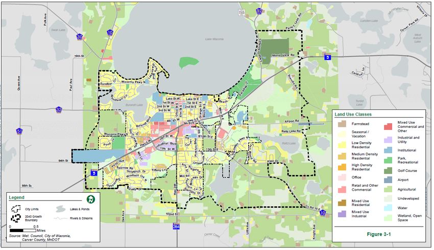
The existing land uses in the City are predominately residential (approximately 45%), with most of the
existing office (0.57%), retail and other commercial (5.66%), and industrial land uses (3.24%) near
State Highway 5 in the central part of the City. Areas on the edges of the City boundaries are mainly
agricultural and wetland/open space (Figure 3).
The Plan is consistent with Thrive for land use and residential density policies for an Emerging
Suburban Edge community designation. As shown in Table 2 below, planned residential densities in the
City between 2017 and 2040 result in an overall minimum density of 3.39 units per acres, which is
consistent with Thrive land use policies.
Page - 3 | METROPOLITAN COUNCILTable 2. Planned Residential Density, City of Waconia
2017-2040 Change
Density
Category Min Max Net Acres Min Units Max Units
Low Density Residential 2 4 521.1 1,042 2,084
Medium Density Residential 4 10 277.4 1,110 2,774
High Density Residential 8 22 120.4 963 2,649
Mixed Use Residential* 10 30 58.0 580 1,740
TOTALS 919.0 3,115 7,508
*30% residential Overall Density 3.39 8.17
The Plan includes objectives related to compact and efficient growth of the perimeter areas of the City.
It includes policies related to maximizing development in existing neighborhoods and prioritizing growth
in areas already served by services. The future land use plan identifies areas with higher intensity of
use, such as commercial, business park, and industrial, around major transportation corridors. It also
prioritizes access to amenities for residential neighborhoods.
Orderly Annexation
The City has an existing orderly annexation agreement (OAA) with Laketown Township. The City’s Plan
acknowledges the OAA and identifies that the land will be annexed from the Township into the City
based on the staging plan, as shown in Figure 5. The area within the OAA is planned to support most of
the City’s planned future growth. As areas are annexed into the City to accommodate the forecasted
growth, the land uses for these areas will reflect Emerging Suburban Edge development patterns.
The City previously had an OAA with Waconia Township, but that agreement expired in 2014 and was
not renewed by the two jurisdictions. Therefore, the City no longer has authority to plan for areas within
Waconia Township. The Plan acknowledges this limitation, while setting goals and policies for future
growth if annexation petitions are received from property owners within the Township. These areas are
illustrated in Figure 3. Acreage included in Table 2 does not include these areas within Waconia
Township.
Agricultural Preserves
There are several large parcels within the orderly annexation area with Laketown Township that are
enrolled in the Agricultural Preserves Program. Parcels enrolled in the Agricultural Preserves Program
must reflect an agricultural designation in the future land use with a maximum density of 1 unit per 40
acres, as required by state law (Minn. Stat. § 473H), until they expire out of the program. As shown in
Figure 4, these areas are depicted with an overlay on the Future Land Use map. The Plan explains that
these parcels will continue to be guided by Carver County at a density of 1 unit per 40 acres until (if
ever) they are annexed to the City, in accordance with their expiration date out of the program.
Advisory Comments
When properties outside of the existing OAA with Laketown Township are annexed into the City, the
City must submit a comprehensive plan amendment to reflect the new boundary and future land use of
the newly annexed properties.
Housing
Reviewer: Tara Beard, CD – Housing (651-602-1051)
The Plan is consistent with the 2040 Housing Policy Plan. Waconia is a growing outer ring suburb that
primarily consists of single-family homes. As of 2016, approximately 81% of its existing housing stock
was single-family. The Plan notes that future growth will require higher intensity development in areas
with better access to regional sewer and transportation infrastructure.
Page - 4 | METROPOLITAN COUNCILThe Plan notes that the City had more than 4,695 housing units in 2016. While roughly 62% of those units were affordable to households earning 80% of the Area Median Income (AMI) or less (or $68,000 for a family of four), affordable options decreased to just 2.5% for households earning 30% AMI or less (or $27,100). Roughly 22% of Waconia households earning 80% AMI or less were housing cost burdened. The Plan notes a need for more affordable housing, and more diverse housing options, including senior housing, to meet the needs of its existing residents. The Plan acknowledges the City’s share of the region’s need for affordable housing in the 2021-2030 decade, which is 863 units. With 254 acres of land guided for higher density residential development in that time period (Figure 6), the Plan sufficiently promotes the availability of land to support that share. The Plan addresses its existing and future housing needs in its implementation plan, which describes the policies, programs and other tools that the City will consider. Tools discussed in the Plan include participation in Livable Communities Act programs, as well as local tools such as issuing housing revenue bonds and creating Tax Increment Financing districts. The implementation plan also states the City will continue to work closely with the Carver County Community Development Agency to meet its existing and future affordable housing needs. Water Supply Reviewer: Lanya Ross, ES – Water Supply Planning (651-602-1803) The Plan is consistent with 2040 WRPP policies related to water supply. Because the City owns and operates a municipal public water supply system, they must include a Local Water Supply Plan (LWSP) as part of the 2040 Plan. The City prepared a LWSP that was submitted to both the Minnesota Department of Natural Resources (DNR) and to the Council with their preliminary comprehensive plan on July 20, 2018. The initial LWSP was considered complete by the Council in a letter to the City on October 1, 2018. However, the Council requested that any changes made after DNR’s technical review of the LWSP be resubmitted to Council. On March 30, 2019, the City submitted the LWSP to the Council as part of their 2040 Plan original submission. The Plan was again considered complete and consistent regarding Water Resources Policy Plan policies related to water supply, and Council staff shared some water supply- related advisory comments in a letter on April 23, 2019. The City updated the LWSP in response to some of the advisory comments and submitted an updated Plan to the Council on October 3, 2019. With the revised LWSP, the City’s 2040 Plan is consistent regarding WRPP policies related to water supply, including the policy on sustainable water supplies, the policy on assessing and protecting regional water resources, and the policy on water conservation and reuse. The Council shared the updated Plan and Council’s review comments with the DNR. The DNR has not yet approved the LWSP. Advisory Comments If changes are made to this LWSP resulting from DNR’s review or from changes during a comprehensive plan amendment, the City will need to provide the Council and DNR with the updated information. Community and Subsurface Sewage Treatment Systems (SSTS) Reviewer: Jim Larsen, CD – Local Planning Assistance (651-602-1159) The Plan indicates that there are neither any individual SSTS nor any public or privately-owned Community Wastewater Treatment Facilities within current City boundaries. The City is fully served by a local wastewater collection system that ultimately flows to the MCES system for conveyance to and treatment at the MCES Blue Lake Wastewater Treatment Plant. All new development, redevelopment, and surrounding areas when annexed are required to be connected to the local collection system. Page - 5 | METROPOLITAN COUNCIL
Special Resource Protection
Solar Access Protection
Reviewer: Cameran Bailey, CD – Local Planning Assistance (651-602-1212)
The Plan is consistent with statutory requirements (Minn. Stat. § 473.859) and Council policy regarding
planning for the protection and development of access to direct sunlight for solar energy systems as
required by the Metropolitan Land Planning Act (MLPA). The Plan includes the required planning
elements.

Aggregate Resource Protection
Reviewer: Jim Larsen, CD – Local Planning Assistance (651-602-1159)
The Plan indicates, consistent with the Council’s aggregate resources inventory information contained
in Minnesota Geological Survey Information Circular 46, that there are no known aggregate resource
deposits within the City or its Orderly Annexation Area.

Historic Preservation
Reviewer: Raya Esmaeili, CD – Local Planning Assistance (651-602-1616)
The Plan includes objectives and policies for preservation of historic resources. The Plan lists seven
buildings within the City that are listed on the National Register of Historic Places. It also identifies
policies for evaluation and rehabilitation so historic structures. The Plan mentions that the City will
coordinate with Carver County Historical Society for assistance, prepare a historical resource survey,
and evaluate properties for historic designations. The City will encourage conservation of existing
resources through public education and local design review.

Plan Implementation
Reviewer: Raya Esmaeili, CD – Local Planning Assistance (651-602-1616)
The Plan includes a description of and schedule for any necessary changes to the capital improvement
program, the zoning code, the subdivision code, the SSTS code, and the housing implementation
program.

The Plan describes the official controls and fiscal devices that the City will employ to implement the
Plan, with capital improvements planning detailed in the appendix 4-A of the Plan.

Compatibility with Plans of Adjacent Governmental Units and Plans of
Affected Special Districts and School Districts
The proposed Plan is compatible with the plans of adjacent jurisdictions. No compatibility issues with
plans of adjacent governmental units and plans of affected special districts and school districts were
identified.

Documents Submitted for Review
In response to the 2015 System Statement, the City submitted the following documents for review:

   •   July 20, 2018: Waconia Preliminary 2040 Comprehensive Plan
   •   March 30, 2019: Waconia 2040 Comprehensive Plan
   •   April 2, 2019: Local Water Supply Plan and Local Surface Water Plan Review Dates
   •   September 23, 2019: Revised 2040 Comprehensive Plan Responding to Council Incomplete
       Items for Wastewater, Land Use, Housing, Mapping, Transportation, Surface Water
       Management, and Water Supply.
   •   October 1, 2019: Revised Water Resources Chapter
   •   October 3, 2019: Updated Water Supply Plan and Revised Water Resources Chapter
   •   November 7, 2019: Revised information on Land Use, Housing, and TAZ Tables
   •   November 25, 2019: Revised 2040 Comprehensive Plan

Page - 6 | METROPOLITAN COUNCIL
Attachments Figure 1: Location Map with Regional Systems Figure 2: Thrive MSP 2040 Community Designations Figure 3: Existing Land Use Figure 4: 2040 Future Land Use Figure 5: Development Staging Map Figure 6: Land Guided for Affordable Housing Page - 7 | METROPOLITAN COUNCIL
Figure 1. Location Map with Regional Systems

Page - 8 | METROPOLITAN COUNCIL
Figure 2. Thrive MSP 2040 Community Designations

Page - 9 | METROPOLITAN COUNCIL
Figure 3. Existing Land Use

Page - 10 | METROPOLITAN COUNCIL
Figure 4. 2040 Future Land Use

Page - 11 | METROPOLITAN COUNCIL
Figure 5. Development Staging Map

Page - 12 | METROPOLITAN COUNCIL
Figure 6. Land Guided for          Affordable
Housing

Page - 13 | METROPOLITAN COUNCIL
You can also read