WATERSHED LAND TRUST, INC. IN-LIEU FEE PROGRAM
←
→
Page content transcription
If your browser does not render page correctly, please read the page content below

WATERSHED LAND TRUST, INC. IN-LIEU FEE PROGRAM
                    NWK-2010-01443
           Prospectus Mitigation Instrument
                           for the

         Diamond Creek Tributary Crossing
             (WLT ILF011-Chase County)

                        Submitted to:
            United States Army Corps of Engineers
                 Kansas City District Office
                        Submitted by:
                 Watershed Land Trust, Inc.

                       March 23, 2021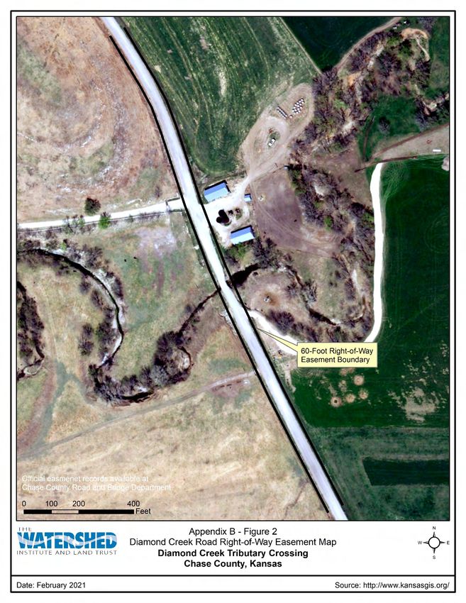
Diamond Creek Tributary Crossing Prospectus Mitigation Instrument

                                                   TABLE OF CONTENTS

INTRODUCTION ...........................................................................................................................1
OBJECTIVES ..................................................................................................................................3
SITE SELECTION ..........................................................................................................................3
SITE PROTECTION INSTRUMENT ............................................................................................6
BASELINE INFORMATION .........................................................................................................6
  Geomorphology ...........................................................................................................................6
  Fish Community ........................................................................................................................10
DETERMINATION OF CREDITS ...............................................................................................11
CREDIT RELEASE SCHEDULE .................................................................................................12
MITIGATION WORK PLAN .......................................................................................................13
OPERATION AND MAINTENANCE PLAN .............................................................................14
PERFORMANCE STANDARDS .................................................................................................14
MONITORING REQUIREMENTS ..............................................................................................15
  Longitudinal Profile and Cross Section Surveys .......................................................................15
LONG TERM MANAGEMENT PLAN .......................................................................................16
ADAPTIVE MANAGEMENT PLAN ..........................................................................................16
FINANCIAL ASSURANCES .......................................................................................................16
EXECUTION AND AGENCY CONCURRENCE.......................................................................17
REFERENCES ..............................................................................................................................21

                                                               TABLES

Table 1: Diamond Creek Tributary Profile Summary ..............................................................…...7
Table 2: Diamond Creek Tributary Geomorphology Classification Summary ........................…...7
Table 3: Diamond Creek Tributary Geomorphology Classification Summary ........................…...8
Table 4: Flint Hills Regional Curve Data Comparison to Diamond Creek Tributary Survey ..….10
Table 5: Diamond Creek Tributary Geomorphology Tracking Table .................................…......15

                                                              FIGURES

Figure 1: Hymer 7.5’ Quadrangle Map ...........................................................................................2
Figure 2: HUC 8 Watershed Map .........................................................................................….......3
Figure 3: Neosho SA Map .....................................................................................................….......4
Figure 4: Diamond Creek Tributary Aquatic Habitat Reconnection ....................................….......5
Figure 5: Diamond Creek Tributary Concrete Box Culvert a) Inlet and b) Outlet. .............….......7
Figure 6: Flint Hills Regional Curve Plots ...........................................................................….......8
Figure 7: Proposed Crossing Profile ..................................................................................….......13
Figure 8: Husker Steel Span Bridge at WLT ILF006-Jefferson County Project.................….......14

Watershed Land Trust, Inc. ILF Program                                                                                                      i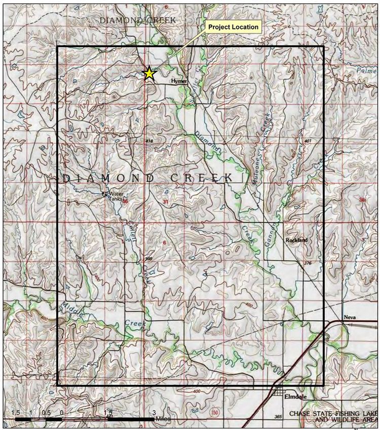
Diamond Creek Tributary Crossing Prospectus Mitigation Instrument

                                    APPENDICIES

A:   Photolog
B:   Operation and Maintenance Recordation
C:   Longitudinal Profile and Cross Section Surveys
D:   Example Span Bridge Design
E:   WLT Response to USACE and Kansas IRT Mitigation Plan Comments

                                     March 23, 2021

Watershed Land Trust, Inc. ILF Program                                                ii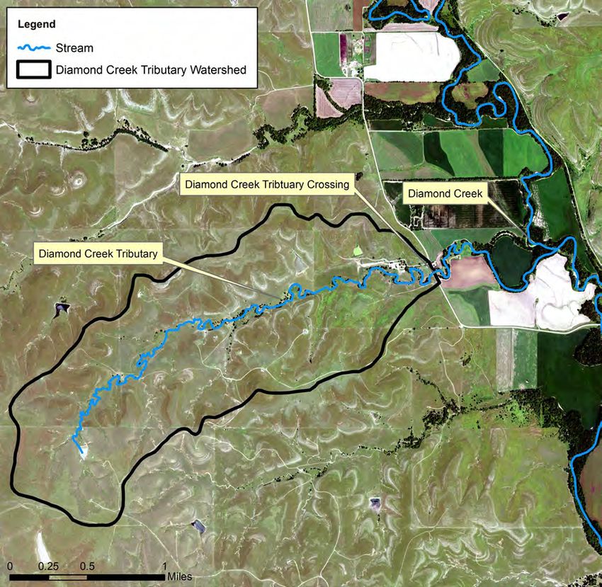
Diamond Creek Tributary Crossing Prospectus Mitigation Instrument

                                      INTRODUCTION

On April 10, 2008, the U.S. Army Corp of Engineers (USACE) and the U.S. Environmental
Protection Agency (USEPA) issued regulations governing compensatory mitigation for activities
authorized by permits issued by the Department of the Army (DA) (Federal Register, Vol. 73. No.
70, pp 19594-19705). These regulations (Final Rule) establish performance standards and criteria
for the use of permittee-responsible compensatory mitigation, mitigation banks, and in-lieu fee
(ILF) programs to implement compensatory projects for activities authorized by USACE permits.
Watershed Land Trust, Inc. (WLT) is a 501(c)(3) non-profit natural resources management
company, and a USACE approved, Kansas statewide ILF provider. WLT ILF program’s
fundamental purpose is to provide compensatory mitigation to offset aquatic resource impacts
resulting from unavoidable losses to waters of the United States (WOUS) authorized by USACE
permits (WLT 2013). Specifically, the WLT ILF program will utilize restoration, establishment,
enhancement, and/or preservation techniques of aquatic resources through funds paid to WLT by
a USACE permit recipient to satisfy compensatory mitigation requirements.

To mitigate existing WLT ILF projects and anticipated mitigation needs, WLT is partnering with
Chase County, Kansas to remove a perched, undersized concrete box culvert on a unnamed
tributary to Diamond Creek and replace it with a span bridge. WLT provided USACE and the
Kansas Interagency Review Team (IRT) a site information packet for WLT ILF project
consideration. On December 18, 2020, Kansas IRT members and USACE unanimously approved
the project for WLT ILF project development. WLT’s ILF program in-stream and mitigation plan
provides information on the mitigation strategy as outlined in In-Lieu Fee Program Instrument
Outline for Proposed In-Lieu Fee Programs in the States of Kansas and Missouri (USACE 2010).

WLT’s ILF program Diamond Creek Tributary crossing (Site) is in Section 18, Township 18
South, and Range 7 East. The approximate center is 38.48985 degrees north latitude and 96.70667
degrees west longitude and is in the Hymer 7.5-minute U.S. Geological Survey (USGS)
Quadrangle (Figure 1). The Site is about 11-miles northwest of Elmdale, Chase County, Kansas
on Diamond Creek Road. A photolog showing site conditions is in Appendix A.

Watershed Land Trust, Inc. ILF Program                                                        1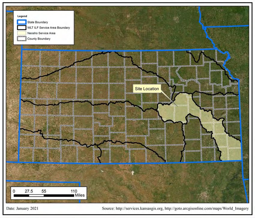
Diamond Creek Tributary Crossing Prospectus Mitigation Instrument

                                       Figure 1: Hymer 7.5’ Quadrangle Map

Source: Copyright @2013 National Geographic Society, i-cubed, http://www.kansasgis.org/

Watershed Land Trust, Inc. ILF Program                                                           2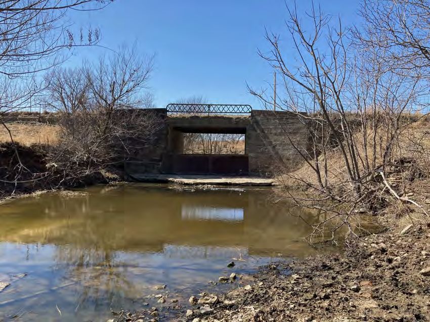
Diamond Creek Tributary Crossing Prospectus Mitigation Instrument

                                                OBJECTIVES

WLT’s mitigation objective is to remove the perched, undersized concrete box culvert. The culvert
will then be replaced a 40-foot span bridge. Mitigation activity objectives are to:

    •   Restore aquatic organism passage, reconnecting about 4.8-miles of Diamond Creek
        Tributary.
    •   Restore existing riffle/pool sequence at the crossing.
    •   Restore reach geomorphology by increasing crossing width to accommodate bankfull
        discharge.

                                               SITE SELECTION

The Site is located on an unnamed tributary to Diamond Creek, a tributary to Diamond Creek and
the Cottonwood River. The Diamond Creek tributary is a first order stream draining approximately
1.6-square miles (USGS 2021). The tributary originates in Chase County uplands and flows about
4.8-miles northeasterly to the confluence with Diamond Creek (USGS 2021). The site is located
within the 11070203 Lower Cottonwood HUC 8 watershed (Figure 2).

                                        Figure 2: HUC 8 Watershed Map

           Source: https://www.kansasgis.org

Watershed Land Trust, Inc. ILF Program                                                         3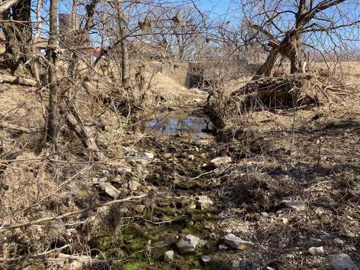
Diamond Creek Tributary Crossing Prospectus Mitigation Instrument

As described in the WLT (2013) ILF Instrument, the ILF program serves Kansas. The Kansas City
District USACE and the Kansas Interagency Review Team (IRT) determined HUC watersheds
(adapted from Seaber at al. 1987) are an appropriate basis to develop Kansas service area (SA)
boundaries or areas of similar biologic character of aquatic systems. WLT’s ILF program is
divided into 10 unique SAs where WLT may offset authorized USACE aquatic impacts within the
same SA as the aquatic impact. Figure 3 shows the Neosho SA boundary, the Site’s SA.

                                   Figure 3: Neosho SA Map

This Site will offset Neosho SA authorized USACE stream aquatic impacts by removing a perched,
undersized concrete box culvert. The culvert will be replaced with a span bridge. The span bridge
will promote aquatic organism passage (AOP) reconnecting about 4.8-miles of Diamond Creek

Watershed Land Trust, Inc. ILF Program                                                         4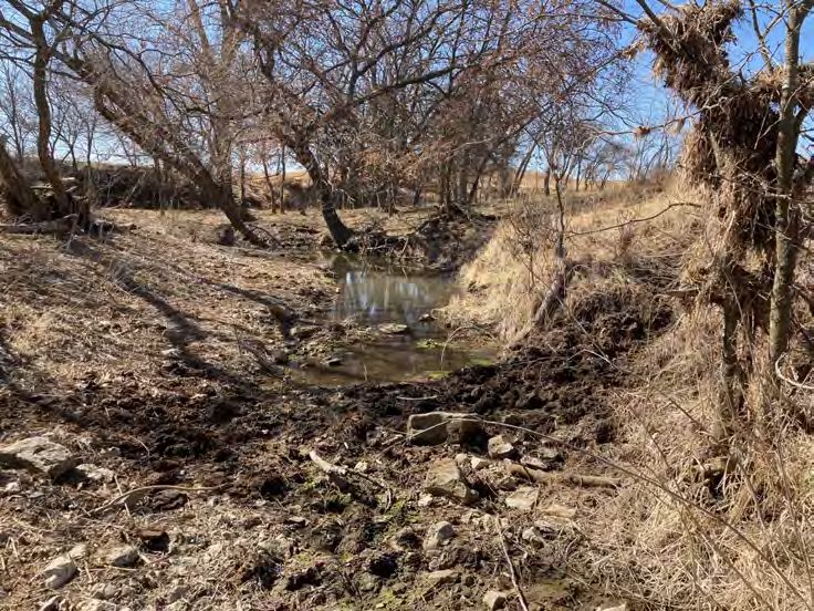
Diamond Creek Tributary Crossing Prospectus Mitigation Instrument

tributary (Figure 4), restore existing tributary riffle/pool sequence at the crossing, and restore reach
geomorphology by allowing the bankfull discharge to through the crossing. WLT’s Neosho SA
stream credit ledger information can be found on USACE’s Regulatory In-Lieu Fee and Bank
Information Tracking System (RIBITS) website.

                  Figure 4: Diamond Creek Tributary Aquatic Habitat Reconnection

    Source: FSA NAIP 2019, USGS National Hydrography dataset

The Site is ecologically suitable for stream mitigation as the existing concrete box culvert
limits/prohibits aquatic organism passage and is undersized compared the bankfull width. The site
is limited to the existing Chase County right-of way easement.

Watershed Land Trust, Inc. ILF Program                                                                5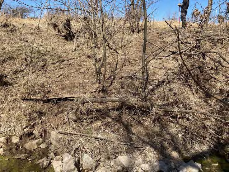
Diamond Creek Tributary Crossing Prospectus Mitigation Instrument

                            SITE PROTECTION INSTRUMENT

Through consultation with USACE and Kansas IRT, the site will be protected under Section 404
of the Clean Water Act by Chase County, as the entire site lies within the county’s right-of-way
easement and all mitigation credits will be generated below the Diamond Creek tributary’s
ordinary high-water mark. The site will be recorded as a permanent mitigation project in Chase
County’s operation and maintenance plan (Appendix B). Chase County is responsible for operating
and maintaining county road and bridges, consistent with this mitigation plan purpose. Chase
County contact information is:

                              Chase County Road and Bridge Department
                              300 Pearl Street
                              Cottonwood Falls, KS 66845

                                 BASELINE INFORMATION

WLT’s ILF program in conjunction with USACE and Kansas IRT approval has chosen this Site
to complete stream mitigation activities. WLT has collected and will continue to collect
information on the channel morphology. The purpose of the baseline information is to ensure WLT
will meet proposed ecological performance-based standards.

Geomorphology

To document the baseline geomorphology, WLT completed a longitudinal profile survey
extending at least two riffle/pool sequences upstream and downstream of Diamond Creek Road.
Longitudinal profile summary data is presented in Table 1. WLT also surveyed two riffle cross
sections upstream and one downstream of the crossing to classify the Diamond Creek tributary.
WLT classified the Diamond Creek Tributary Reach as a Rosgen (1994) C4/1 stream type with
and average bank height ratio of 1.0. Cross section and profile plots are presented in Appendix C.
The geomorphology classification results are presented in Table 2. Downstream from Diamond
Creek Road, the reach flows over exposed bedrock and Cross Section 3 is representative of the
bedrock influenced channel shape.

The existing crossing consists of a 16-foot wide, 15-foot high—including a 3-foot-high concrete
floor—concrete box culvert with floor slope of 0.01868 feet/feet. Water flows through the concrete

Watershed Land Trust, Inc. ILF Program                                                          6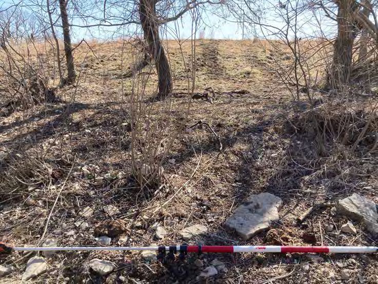
Diamond Creek Tributary Crossing Prospectus Mitigation Instrument

box culvert as sheet flow and at the culvert outlet, the stream has about a 0.6-feet vertical drop to
the downstream pool (Figure 5). Existing crossing conditions prevent most AOP to 4.1-miles of
upstream habitat within the Diamond Creek tributary (Figure 4).

                       Table 1: Diamond Creek Tributary Profile Summary

                                       Minimum                Average              Maximum
 Riffle Slope (ft/ft)                  0.01938                0.03632               0.05903
 Pool Slope (ft/ft)                    0.00055                0.00068               0.00078
 Run Slope (ft/ft)                     0.00377                0.00820               0.01251
 Glide Slope (ft/ft)                   0.00209                0.00223               0.00240
 Pool-Pool Spacing (ft)                 57.52                  111.83                211.07
 Pool Length                            13.95                   44.92                163.07

          Table 2: Diamond Creek Tributary Geomorphology Classification Summary

                                                Upstream Riffle     Downstream Riffle
                                                      XS                  XS
            Bankfull Width (Ft)                      19.44                38.3
            Bankfull Mean Depth (Ft)                   1.5                 1.4
            Width/Depth Ratio                         13.3                27.9
            Width of Floodprone Area (Ft)             57.9                80.8
            Entrenchment Ratio                         3.0                 2.1
            Channel Materials D50                    28.48             Bedrock
            Average Water Surface Slope            0.00823              0.00823
            Sinuosity                                 1.71                1.71
            Stream Type                                C4                  C1

        Figure 5: Diamond Creek Tributary Concrete Box Culvert a) Inlet and b) Outlet.

   a)                                                 b)

Watershed Land Trust, Inc. ILF Program                                                             7
Diamond Creek Tributary Crossing Prospectus Mitigation Instrument
WLT used regional curve data from previous Flint Hills stream surveys to calibrate Diamond
Creek tributary bankfull discharge and channel dimensions. Table 3 and Figure 6 compares the
regional curve data used for calibrating Diamond Creek tributary drainage area to bankfull
discharge, bankfull cross-section area, bankfull width, and bankfull mean depth. To calculate the
Diamond Creek Tributary bankfull mean velocity, WLT used Manning’s n of 0.033, the average
between small C4 and C1 streams without vegetation influence (Rosgen 1994).
Table 3: Flint Hills Regional Curve Data Comparison to Diamond Creek Tributary Survey
Flint Hills Regional Curve Diamon Creek Tributary Survey
Bankfull Discharge (cfs) 96.17 120.6
Bankfull Area (Sq Ft) 29.21 25.5
Bankfull Width (Ft) 29.21 19.9
Bankfull Mean Depth (F) 1.21 1.3
Figure 6: Flint Hills Regional Curve Plots
Watershed Land Trust, Inc. ILF Program 8Diamond Creek Tributary Crossing Prospectus Mitigation Instrument
Figure 6: Flint Hills Regional Curve Plots (continued)
Watershed Land Trust, Inc. ILF Program 9Diamond Creek Tributary Crossing Prospectus Mitigation Instrument
Figure 6: Flint Hills Regional Curve Plots (continued)
Fish Community
Kansas Department of Wildlife, Parks, and Tourism (KDWPT) (KDWPT 1994-2018) has
completed multiple stream assessment surveys on Diamond Creek and similar-sized streams
within the Site’s HUC 10 watershed (1107020302). KDWPT’s (1994-2018) historic fish
community for Diamond Creek is listed in Table 4. WLT did not observe live mussels or mussel
shells during the geomorphology survey.
Table 4: Diamond Creek and HUC 1107020302 Watershed 1st Order Stream Fish Community
(KDWPT 1994-2018)
Common Name Scientific Name Diamond Creek 1st Order Streams
Black Bullhead Ameiurus melas
Bluegill Lepomis macrochirus
Bluntface Shiner Cyprinella camura
Bluntnose Minnow Pimephales notatus
Brook Silverside Labidesthes sicculus
Cardinal Shiner Luxilus cardinalis
Central Stoneroller Campostoma anomalum
Channel Catfish Ictalurus punctatus
Watershed Land Trust, Inc. ILF Program 10Diamond Creek Tributary Crossing Prospectus Mitigation Instrument
Table 4: Diamond Creek and HUC 1107020302 Watershed 1st Order Stream Fish Community
(KDWPT 1994-2018)
Common Name Scientific Name Diamond Creek 1st Order Streams
Channel Darter Percina copelandi
Common Carp Cyprinus carpio
Creek Chub Semotilus atromaculatus
Fantail Darter Etheostoma flabellare
Flathead Catfish Pylodictis olivaris
Fathead Minnow Pimephales promelas
Freshwater Drum Aplodinotus grunniens
Golden Redhorse Moxostoma erythrurum
Green Sunfish Lepomis cyanellus
Largemouth Bass Micropterus salmoides
Logperch Percina caprodes
Longear Sunfish Lepomis megalotis
Orangespotted Sunfish Lepomis humilis
Orangethroat Darter Etheostoma spectabile
Red Shiner Cyprinella lutrensis
Redfin Shiner Lythrurus umbratilis
Sand Shiner Notropis stramineus
Shortnose gar Lepisosteus platostomus
Slenderhead Darter Percina phoxocephala
Slim Minnow Pimephales tenellus
Smallmouth Buffalo Ictiobus bubalus
Spotted Bass Micropterus punctulatus
Stonecat Noturus flavus
Suckermouth Minnow Phenacobius mirabilis
Topeka Shiner Notropis topeka
Western Mosquitofish Gambusia affinis
White Crappie Pomoxis annularis
Yellow Bullhead Ameiurus natalis
DETERMINATION OF CREDITS
WLT proposes to complete in-stream mitigation work within the Chase County right-of-way
easement. WLT’s in-stream mitigation strategy includes removing the existing perched concrete
box culvert and replacing the culvert with a 40-foot span bridge. WLT will generate stream credits
through connecting aquatic habitats and improving geomorphic stability by passing the bankfull
discharge through the span bridge. WLT is using the KSMG, Version 3 (USACE 2018) with
Watershed Land Trust, Inc. ILF Program 11Diamond Creek Tributary Crossing Prospectus Mitigation Instrument
consultation with USACE and the Kansas IRT to determine stream credits generated by the
mitigation activity. If a change in stream credits assessment methods occurs, the currently
approved stream credits will be grandfathered and remain unchanged.
CREDIT RELEASE SCHEDULE
Upon approval by USACE, in consultation with the Kanas IRT, the stream credits will become
available for use by WLT in accordance with the described schedule. WLT will provide detailed
descriptions of credits releases commensurate with associated accomplishment of mitigation
activities and/or performance standards. Generally, credit releases will follow the three criteria
described below.
1. 20-percent of the total proposed stream credits shall be available to satisfy Lower Republican-
Kansas SA projects when: (1) USACE approves the mitigation plan and (2) WLT’s financial
assurances have been appropriately established and funded.
2. 30-percent of the total number of the generated stream credits shall become available to satisfy
Neosho SA projects when construction is complete, WLT submits an As-Built report, and
USACE approves construction in consultation with the Kansas IRT. Chase County will
complete required local, state, and federal permit applications and receive permit approval
prior to construction.
3. 10-percent of the total number stream credits shall become available annually to satisfy Lower
Neosho SA projects following submittal of annual monitoring reports that demonstrate WLT
has satisfied in-stream performance standards for a minimum period of five years (i.e.
minimum monitoring period). Success of each annual monitoring report for five years will
result in the summation of the remaining 50-percent of total stream credits.
USACE, in consultation with the Kansas IRT, shall release credits to WLT following the proposed
credit release schedule. WLT will submit documentation to USACE to support completed
performance milestones. USACE will supply WLT’s documentation to the Kansas IRT. After
USACE has received comments from Kansas IRT members, USACE will accept or reject the
performance milestones. USACE shall make this determination within 30 days of the end of the
comment period and shall notify WLT and the Kansas IRT of their decision.
Watershed Land Trust, Inc. ILF Program 12Diamond Creek Tributary Crossing Prospectus Mitigation Instrument
USACE, in consultation with the Kansas IRT, may modify the credit release schedule, adjust the
number of available credits, or suspend credit sales or transfers if USACE determines there are
deficiencies in the ecological performance standards or mitigation plan requirements.
MITIGATION WORK PLAN
The mitigation work plan consists of removing the perched, concrete box culvert replacing it with
a Husker Steel 40-foot long by 24.5-foot-wide span bridge. Based on the longitudinal survey, WLT
does not recommend stream grade control structures as the profile suggests that the pool habitat
be expanded beneath the span bridge. Figure 7 shows an example of a proposed profile at the
crossing. Pool depths can vary and should be consistent with upstream and downstream pools
documented in the longitudinal profile. Figure 8 shows a picture of a Husker Steel span bridge
from the approved WLT ILF006-Jefferson County project. Appendix D and an example span
bridge design with plan view, profile, and typical cross sections. WLT will provide USACE and
the Kansas IRT with final plans once available.
Figure 7: Proposed Crossing Profile
Watershed Land Trust, Inc. ILF Program 13Diamond Creek Tributary Crossing Prospectus Mitigation Instrument
Figure 8: Husker Steel Span Bridge at WLT ILF006-Jefferson County Project
OPERATION AND MAINTENANCE PLAN
WLT has partnered with Chase County to operate and maintain the proposed span bridge. Chase
County will enter the span bridge into Kansas Department of Transportation (KDOT) bridge
inventory and will receive biannual inspections. Maintenance objectives will be to maintain
Diamond Creek tributary hydrology as permitted. Other maintenance activities will be to remove
any nuisance, exotic, or non-native plants as listed by the State of Kansas.
PERFORMANCE STANDARDS
The proposed mitigation activity will improve channel geomorphology by replacing a perched,
undersized culvert with a span bridge. For stable geomorphology dimension, pattern, profile, and
fish passage, the passage opening should be as large as the bankfull channel to allow no backwater
or increased velocity during the bankfull event (KU Transportation Center 2015). An objective,
measurable procedure to document crossing effectiveness is to complete pre- and post-construction
longitudinal profile and cross section surveys. A longitudinal profile survey provides a method for
providing detailed information about the streambed form such as identifying riffle/pool sequence
dimensions, identifying the length and depth of accumulated sediment or areas of scour, and a way
to determine the natural stream gradient (KU Transportation Center 2015 and Harman et al 2012).
A cross section survey provides a method to determine the area of sediment accumulation or scour
and streambank slope, to determine if lateral migration is the result of stable but active dynamic
Watershed Land Trust, Inc. ILF Program 14Diamond Creek Tributary Crossing Prospectus Mitigation Instrument
channel processes or result of a stream out of equilibrium, and to determine changes is area, width,
and depth (Harman et al 2012). The objective monitoring data will help validate ecological
function by making evident geomorphology stability and aquatic organism effectiveness.
Performance Standards
1. The average water surface slope, streambed elevation, and cross section area will be within 10-
percent of as-built survey dimensions.
MONITORING REQUIREMENTS
WLT will monitor the Kansas ILF project for a minimum of five years post-construction to support
performance standard achievements and to recommend maintenance or adaptive management (if
needed). USACE may extend or waive monitoring based upon performance standard results.
USACE, through coordination with the Kansas IRT, maintains the authority to modify, extend or
waive monitoring requirements. WLT will submit to USACE and Kansas IRT an annual
monitoring report that includes information described in this section.
Longitudinal Profile and Cross Section Surveys
WLT will complete, on an annual basis for five years post-construction, longitudinal profile and
cross section surveys at locations consist with data presented in Appendix C. The longitudinal
survey will extend at least two riffle/pool sequences upstream and downstream of the completed
crossing. WLT will compare monitoring surveys with the as-built survey to determine slope,
streambed elevation, and cross section deviations. The data will be entered into Table 5.
Table 5: Diamond Creek Tributary Crossing Geomorphology Tracking Table.
Monitoring Year
Survey Parameter Pre-Construction As-Built 1 2 3 4 5
Profile Slope 0.00823 ft/ft
Upstream Streambed Elevation 985.2 ft
Cross Section Cross Section Area 28.3 sq ft
Downstream Streambed Elevation 983.44 ft
Cross Section Cross Section Area 52.5 sq ft
Watershed Land Trust, Inc. ILF Program 15Diamond Creek Tributary Crossing Prospectus Mitigation Instrument
LONG TERM MANAGEMENT PLAN
Chase County will be responsible for long-term management of the span bridge structure in
accordance with permit and mitigation plan requirements. Potential maintenance activities include
invasive species removal, trash/woody debris removal, and as-needed site inspections.
ADAPTIVE MANAGEMENT PLAN
If the span bridge cannot be built as approved without significant change orders, WLT will notify
USACE. Significant modifications to the permitted design will require USACE approval, in
consultation with the IRT, prior to change order approval. Active input from the IRT is welcome
and encouraged. WLT will use an adaptive management approach to deal with unforeseen issues.
If unforeseen circumstances arise so that the mitigation project cannot meet performance
standards, then WLT will approach USACE with suggestions or changes that are commensurate
toward meeting mitigation objectives. If necessary, performance standards may require revising.
Any revisions will be commensurate or superior to original performance standards.
FINANCIAL ASSURANCES
The WLT ILF Program is committed to funding quality compensatory mitigation project sites that
construct, monitor, and provide long-term management for aquatic natural resources throughout
the state of Kansas. The WLT ILF Program incorporated financial assurances into its cost-per-unit
and will retain pooled financial assurances in a contingency fund within a Certificate of Deposit
(CD) account, like other ILF programs in USACE Kansas City District. This ensures a high level
of confidence that the WLT ILF Program Rock Creek Stream Mitigation Site will be successfully
completed and maintained in accordance with applicable performance standards. WLT will notify
USACE at least 120 days in advance of any principal withdrawal from the contingency fund or
termination of the account.
Watershed Land Trust, Inc. ILF Program 16Diamond Creek Tributary Crossing Prospectus Mitigation Instrument
EXECUTION AND AGENCY CONCURRENCE
The Kansas City District, Corps of Engineers, along with the members of the Interagency Review
Team, have participated with the In-Lieu Fee (ILF) sponsor (Watershed Land Trust, Inc. [WLT])
in the development of the Diamond Creek Tributary Crossing Final Mitigation Plan. The Plan
represents ILF Project Site #11 under the current WLT ILF instrument.
I have determined that the final plan is complete and that the development of ILF Project Site #11
will provide appropriate compensation for impacts to streams associated with unavoidable impacts
to these resources that resulted from activities authorized by the Kansas City District’s issuance of
Department of the Army permits.
_________________________________________ Date: ________________________
Mark D. Frazier
Chief, Regulatory Branch
Operations Division
Watershed Land Trust, Inc. ILF Program 17Diamond Creek Tributary Crossing Prospectus Mitigation Instrument INTERAGENCY REVIEW TEAM CONCURRENCE: The U.S. Environmental Protection Agency, along with the members of the Interagency Review Team, has participated with the In-Lieu Fee (ILF) sponsor (Watershed Land Trust, Inc. [WLT]) in the development of the Diamond Creek Tributary Crossing Final Mitigation Plan. The Plan represents ILF Project Site #11 under the current WLT ILF instrument. I concur that the final plan is complete and that the development of ILF Project Site #11 will provide appropriate compensation for impacts to streams associated with unavoidable impacts to these resources that resulted from activities authorized by the Kansas City District’s issuance of Department of the Army permits. _________________________________________ Date: ________________________ Jeffery Robichaud Director Water, Wetlands and Pesticides Division Watershed Land Trust, Inc. ILF Program 18
Diamond Creek Tributary Crossing Prospectus Mitigation Instrument

INTERAGENCY REVIEW TEAM CONCURRENCE:

The U.S. Fish and Wildlife Service, along with the members of the Interagency Review Team, has
participated with the In-Lieu Fee (ILF) sponsor (Watershed Land Trust, Inc. [WLT]) in the
development of the Diamond Creek Tributary Crossing Final Mitigation Plan. The Plan represents
ILF Project Site #11 under the current WLT ILF instrument.

I concur that the final plan is complete and that the development of ILF Project Site #11 will
provide appropriate compensation for impacts to streams associated with unavoidable impacts to
these resources that resulted from activities authorized by the Kansas City District’s issuance of
Department of the Army permits.

_________________________________________                   Date: ________________________
Jason Luginbill
Kansas Field Supervisor
U.S. Fish and Wildlife Service

Watershed Land Trust, Inc. ILF Program                                                         19
Diamond Creek Tributary Crossing Prospectus Mitigation Instrument

INTERAGENCY REVIEW TEAM CONCURRENCE:

The Kansas Department of Wildlife, Parks and Tourism, along with the members of the
Interagency Review Team, has participated with the In-Lieu Fee (ILF) sponsor (Watershed Land
Trust, Inc. [WLT]) in the development of the Diamond Creek Tributary Crossing Final Mitigation
Plan. The Plan represents ILF Project Site #11 under the current WLT ILF instrument.

I concur that the final plan is complete and that the development of ILF Project Site #11 will
provide appropriate compensation for impacts to streams associated with unavoidable impacts to
these resources that resulted from activities authorized by the Kansas City District’s issuance of
Department of the Army permits.

_________________________________________                   Date: ________________________
Mike Miller
Assistant Secretary
Kansas Department of Wildlife, Parks and Tourism

Watershed Land Trust, Inc. ILF Program                                                         20
Diamond Creek Tributary Crossing Prospectus Mitigation Instrument

                                       REFERENCES

Harman, W., R. Starr, M. Carter, K. Tweedy, M. Clemmons, K. Suggs, C. Miller. 2012. A
      Function-Based Framework for Stream Assessment and Restoration Projects. US
      Environmental Protection Agency, Office of Wetlands, Oceans, and Watersheds,
      Washington, DC EPA 843-K-12-006.

Kansas Department of Wildlife, Parks and Tourism (KDWPT). 1994-2018. Stream Survey and
      Assessment Program Database. Ecological Services Section, Pratt, KS.

KU Transportation Center. 2015. Kansas Fish Passage Guide: A guide for constructing stream
      crossings on local road and private drives to provide for fish passage. Kansas Local
      Technical Assistance Program. Lawrence, Kansas.

Rosgen, D.L. 1994. A Classification of Natural river. Catena Vol. 22, 169−199.

Seaber, P.R., Kapinos, F.P., and Knapp, G.L. 1987. Hydrologic Unit Maps. U.S. Geological
       Survey Water-Supply Paper 2294. U.S. Government Printing Office. 63 p.

U.S. Army Corps of Engineers (USACE).

   2010.    In-Lieu Fee Program Instrument Outline for Proposed In-Lieu Fee Programs in the
            States of Kansas and Missouri. February. Accessed on-line at:
            http://www.nwk.usace.army.mil/regulatory/CompMit/compmit.htm.

   2018     Kansas Stream Mitigation Guidance - Version 3 – August 13, 2018. Kansas City
            District Regulatory Office.

U.S. Geological Survey (USGS). 2021. National Hydrology Database Plus High Resolution
      database. Accessed online at: NHDPlus High Resolution (usgs.gov)

Watershed Land Trust, Inc. (WLT). October 2013. Watershed Land Trust Aquatic Resource
      Mitigation Program – State of Kansas.

Watershed Land Trust, Inc. ILF Program                                                  21
Diamond Creek Tributary Crossing Prospectus Mitigation Instrument
APPENDIX A
PROJECT PHOTOLOG
Watershed Land Trust, Inc. ILF ProgramWLT ILF Program
WLT ILF011-Chase County
Appendix A Photolog
Photo Number: 1
Client: USACE/Kansas IRT
Description: Concrete box culvert
inlet.
Direction: East
Photographer: Brock Emmert
Date: March 11, 2021
Photo Number: 2
Client: USACE/Kansas IRT
Description: Beginning of stream
profile survey looking upstream
Direction: North
Photographer: Brock Emmert
Date: March 11, 2021
A-1WLT ILF Program
WLT ILF011-Chase County
Appendix A Photolog
Photo Number: 3
Client: USACE/Kansas IRT
Description: XS1 1 looking
upstream
Direction: North
Photographer: Brock Emmert
Date: March 11, 2021
Photo Number: 4
Client: USACE/Kansas IRT
Description: XS1 looking
downstream.
Direction: South
Photographer: Brock Emmert
Date: March 11, 2021
A-2WLT ILF Program
WLT ILF011-Chase County
Appendix A Photolog
Photo Number: 5
Client: USACE/Kansas IRT
Description: Left bank at XS1
Direction: East
Photographer: Brock Emmert
Date: March 11, 2021
Photo Number: 6
Client: USACE/Kansas IRT
Description: Right bank at XS1
Direction: West
Photographer: Brock Emmert
Date: March 11, 2021
A-3WLT ILF Program
WLT ILF011-Chase County
Appendix A Photolog
Photo Number: 7
Client: USACE/Kansas IRT
Description: XS2 looking
upstream
Direction: Southwest
Photographer: Brock Emmert
Date: March 11, 2021
Photo Number: 8
Client: USACE/Kansas IRT
Description: XS2 looking
downstream
Direction: Northeast
Photographer: Brock Emmert
Date: March 11, 2021
A-4WLT ILF Program
WLT ILF011-Chase County
Appendix A Photolog
Photo Number: 9
Client: USACE/Kansas IRT
Description: Left bank at XS2
Direction: Northwest
Photographer: Brock Emmert
Date: March 11, 2021
Photo Number: 10
Client: USACE/Kansas IRT
Description: Right bank at XS2
Direction: Southeast
Photographer: Brock Emmert
Date: March 11, 2021
A-5WLT ILF Program
WLT ILF011-Chase County
Appendix A Photolog
Photo Number: 11
Client: USACE/Kansas IRT
Description: Concrete box culvert
outlet.
Direction: West
Photographer: Brock Emmert
Date: March 11, 2021
Photo Number: 12
Client: USACE/Kansas IRT
Description: XS3 looking
upstream.
Direction: West
Photographer: Brock Emmert
Date: March 11, 2021
A-6WLT ILF Program
WLT ILF011-Chase County
Appendix A Photolog
Photo Number: 13
Client: USACE/Kansas IRT
Description: XS3 looking
downstream
Direction: East
Photographer: Brock Emmert
Date: October 22, 2020
Photo Number: 14
Client: USACE/Kansas IRT
Description: Left bank at XS3
Direction: North
Photographer: Brock Emmert
Date: March 11, 2021
A-7WLT ILF Program
WLT ILF011-Chase County
Appendix A Photolog
Photo Number: 15
Client: USACE/Kansas IRT
Description: Right bank at XS3
Direction: South
Photographer: Brock Emmert
Date: March 11, 2021
Photo Number: 16
Client: USACE/Kansas IRT
Description: Concrete box culvert
inlet
Direction: N/A
Photographer: Austin Roth
Date: March 11, 2021
A-8WLT ILF Program
WLT ILF011-Chase County
Appendix A Photolog
Photo Number: 17
Client: USACE/Kansas IRT
Description: Left bank and
concrete box culvert outlet
Direction: N/A
Photographer: Austin Roth
Date: March 11, 2021
Photo Number: 18
Client: USACE/Kansas IRT
Description: Concrete box culvert
and Diamond Creek Road
Direction: North
Photographer: Austin Roth
Date: March 11, 2021
A-9Diamond Creek Tributary Crossing Prospectus Mitigation Instrument
APPENDIX B
OPERATION AND MAINTENANCE RECORDATION
Watershed Land Trust, Inc. ILF ProgramAppendix B
NOTICE OF PERMANENT MITIGATION PROJECT
That on or about_______________, Chase County and Watershed Land Trust, Inc. (WLT) entered
into a Memorandum of Understanding regarding the Diamond Creek tributary on Diamond Creek
Road, with the approval of the US Army Corps of Engineers (Corps).
1. This Appendix is to be filed as a permanent record in the Chase County’s operation and
maintenance (O&M) plan.
2. The bridge and stream project are part of a permanent mitigation project under the WLT
ILF Program.
3. All mitigation activity will occur below the ordinary high-water mark (OHWM) of the
Diamond Creek Tributary and is located within Chase County’s right-of-way (ROW).
4. Any proposed modification to the bridge or stream channel within the ROW will require
prior approval from the Corps.
5. The Corps address is: Corps Kansas State Regulatory Office, 2710 NE Shady Creek
Access Road, El Dorado, KS 67042.
6. The official file number for the Corps is: NWK-2010-01443, WLT ILF011-Chase County.
7. Attached hereto are the official ROW easement descriptions, Project Location Map, and
Project Layout Map.
Filed into the Chase County operation and maintenance plan this ____________ day of
_________________, 2021.
By,
_________________________
Name
_________________________
Title
Seal
B-1B-2
B-3
Diamond Creek Tributary Crossing Prospectus Mitigation Instrument

                                                                   APPENDIX C

                    LONGITUDINAL PROFILE AND CROSS SECTION SURVEYS

Watershed Land Trust, Inc. ILF Program
C-1
C-2
C-3
C-4
Diamond Creek Tributary Crossing Prospectus Mitigation Instrument

                                                                   APPENDIX D

                                             EXAMPLE SPAN BRIDGE DESIGN

Watershed Land Trust, Inc. ILF Program
Diamond Creek Tributary Crossing Prospectus Mitigation Instrument
APPENDIX E
WLT RESPONSES TO USACE AND KANSAS IRT MITIGATION PLAN
COMMENTS
Watershed Land Trust, Inc. ILF ProgramYou can also read