COMPREHENSIVE PLAN FOR - West Lakeland Township Washington County, Minnesota - Prepared By
←
→
Page content transcription
If your browser does not render page correctly, please read the page content below

COMPREHENSIVE PLAN FOR
                                 West Lakeland Township
                                 Washington County, Minnesota

Adopted: October 11, 2010                                Prepared By:
                                       West Lakeland Township Board
                                            And Planning Commission

WEST LAKELAND TOWNSHIP, MINNESOTA

          COMPREHENSIVE PLAN

                     Prepared by
 West Lakeland Township Board and Planning Commission

           Dated: October 11, 2010

                                                        1
TOWN BOARD

           Dan Kyllo, Chair
         Ron Goette, Supervisor
        Dave Schultz, Supervisor

    TOWN PLANNING COMMISSION

           Dr. Ray Swanson
             Loren Kalel
            Mark Votava
             Dale Borash
              Ed Gorman
             Betsy Vance
            Erik Knutson
             Dave Dupay

2
TABLE OF CONTENTS
1)   Introduction............................................................................................................. 5
2)   Authorization........................................................................................................... 7
3)   Community Overview ............................................................................................. 7
4)   Population Analysis ............................................................................................... 8
5)   Economic Analysis ................................................................................................. 8
6)   Major Development Issues .................................................................................... 9
  a)      Pre-Existing Nonconforming Commercial Uses ........................................... 9
  b)      Interstate 94...................................................................................................... 9
  c)      Airport Facilities............................................................................................... 9
  e)      Zoning ............................................................................................................. 12
7) Surface Water Management Plan ........................................................................ 12
8) Agricultural Trends............................................................................................... 23
9) Land Use Plan ....................................................................................................... 23
  a)      Introduction .................................................................................................... 23
  b)      Existing Land Use .......................................................................................... 23
  c)      Natural Resource Areas ................................................................................ 24
  d)      Aggregate Resources .................................................................................... 25
  e)      Land Use Policies and Plan .......................................................................... 25
  f)      Land Use Summary ....................................................................................... 31
10) Housing Plan ......................................................................................................... 31
11) Public Facilities Plan ............................................................................................ 32
12) Transportation Plan .............................................................................................. 32
13) Sanitary Sewer Plan ............................................................................................. 39
14) Stormwater Drainage Plan ................................................................................... 40
15) Surface Water/Ground Water Management Plan ............................................... 43
16) Parks and Open Space Plan ................................................................................ 43
17) Miscellaneous Public Facilities or Services ....................................................... 44
18) Energy and Solar Access ..................................................................................... 45
19) Historic Preservation............................................................................................ 45
20) Implementation ..................................................................................................... 45
21) Conclusion ............................................................................................................ 45
22) Appendix: West Lakeland Township 2000 Census Data ................................... 46

                                                                                                                               3
EXHIBITS

Figure 1 - West Lakeland Township ............................................................................ 5
Figure 2 - Regional Area Planning Map ....................................................................... 6
Figure 3 - Lake Elmo Airport Surface Noise ............................................................. 10
Figure 4 - Lake Elmo Airport and Overlay Zone ....................................................... 11
Figure 5 - Zoning Map ................................................................................................. 13
Figure 6 – Wetland Inventory Map ............................................................................. 14
Figure 7 - Watershed Boundaries .............................................................................. 15
Figure 8 - Steep Slope Areas ...................................................................................... 25
Figure 9 - Possible Mining Area ................................................................................. 28
Figure 10 - Present Land Use ..................................................................................... 29
Figure 11 - Future Land Use ....................................................................................... 30
Figure 12 – Recommended Street Spacing for IRCs ................................................ 33
Figure 13 – Recommended Street Spacing for Non-IRCs ........................................ 34
Figure 14 – TAZ Forecasts West Lakeland ............................................................... 35
Figure 15 – TAZs in West Lakeland ........................................................................... 36
Figure 16 - Road Jurisdictional Map .......................................................................... 37
Figure 17 - Future Road Plan ..................................................................................... 38
Figure 18 - Middle St. Croix Water Management Boundaries .................................. 41
Figure 19 - Valley Branch Watershed District Drainage Pattern Map ..................... 42

4
1) Introduction
  West Lakeland Township is, by definition, an urban Township located along the St. Croix
  River in east central Washington County; a rural residential community, proud of the unique
  lifestyle enjoyed by its residents. The goals of the residents expressed through this
  Comprehensive Plan include to continue and to encourage this unique rural lifestyle, to
  preserve a rural environment, and to limit the need for urban services.

                                Figure 1 - West Lakeland Township

                                                                                                5
Figure 2 - Regional Area Planning Map

6
The Township is governed by an elected three member board, meeting monthly in public
  session. Part time staff as needed include at present a Township attorney, consulting
  engineer, building inspector, clerk, treasurer, two deputy clerks, animal control officer,
  treasurer, and town road maintenance personnel. Other public services are contracted as
  needed from the County, nearby communities or private sector as required.
  By State Statute, West Lakeland Township is required to prepare and submit a
  Comprehensive Plan. The local Comprehensive Plan is a public document that describes how
  that community views future development over a specified planning period.

2) Authorization
  This Comprehensive Plan is prepared pursuant to the Metropolitan Land Planning Act,
  Minnesota Statutes Section 473.175 and Sections 473.851 to 473.872. Major
  metropolitan systems are not altered by the contents of this Plan, nor are any major
  changes in Township policy presented.

3) Community Overview
  When Minnesota became a state in 1858, and townships were being organized,
  Lakeland Township was proposed to extend from Stillwater to Afton on Lake St. Croix.
  However, there were already several communities established along the St. Croix River,
  with most people living in Baytown Village (Bayport) and Shanghai Cooley (Lakeland).
  Both communities’ citizens objected to going to other places to vote or do business.

  The township formation committee came up with a compromise: the north half of the
  township became Baytown and the south half Lakeland. Lakeland was organized as a
  township October 20, 1858.

  When Lakeland incorporated as a village in July of 1950, West Lakeland was split off
  and organized as a Township. The village kept the developed land and the new
  township became strictly rural. West Lakeland remained agricultural in character until
  the 1960’s, when a housing boom occurred. Divided by Minnesota State Highway 12,
  the newly created Township of 8,400 acres was populated by small farms and rural
  homes of area residents on large, self contained lots. Older homes characteristic of the
  St Croix Valley remain in the area. Much of its history, however, is shared by its
  neighbors. The residents and farms have contributed much to the unobstructed lifestyle
  of the Township. This rural life is one which allows the area residents to enjoy the
  benefits of a rural community close to an urban center. All residents can enjoy the
  atmosphere of open space and the rural pace important to Minnesota’s high quality of
  life through loosely knit neighborhoods, decentralized in nature, with curved paved
  streets and rolling terrain. It is a family community, close to urban centers, but with the
  benefits of rural living.

  The Metropolitan Council now considers West Lakeland Township a “Diversified Rural”
  planning area (See Figure 2). Because of the extent of development within the
  Township, West Lakeland will not be able to meet the requirements for this planning
  area and should have our designation change to “Rural Residential”.

                                                                                                7
4) Population Analysis
    The population of West Lakeland Township has been growing steadily, over the almost sixty
    years of its existence. The residents and population forecasters, therefore, continue to see the
    Township as essentially rural with a low density beyond the year 2030. Indeed, this is the goal of
    the residents. Population forecasts supplied by the Metropolitan Council and from the 1990 and
    2000 Census indicate the following figures for West Lakeland Township

                                     Table 1 – Population Analysis
          Year       Population      Households       Density        Households   Employm
                                                      (persons       per Acre     ent
                                                      per acre)
          1970       772             186              0.09           0.24         10
          1976       1,128           305              0.13           0.27         50
          1980       1,315           350              0.15           0.27         50
          1990       1,500           450              0.18           0.30         50
          2000       3,542           1,093            0.42           0.31         75
          2010       3,860           1,290            0.45           0.33         300
          2020       3,950           1,400            0.47           0.35         300
          2030       4,190           1,510            0.49           0.36         300

    At these predicted rates, the average density for the Township at maximum predicted households
    will be well within any limits necessary to maintain the rural character of the Township.
    Continuing slow growth assures the rural atmosphere will remain. The Township expects
    moderate growth but plans to accommodate this growth without providing urban services.

    The Township is a bedroom community for families of area residents coexisting with a small
    amount of nonresidential uses. The majority of the residents live in individual single family
    homes. Most of these homes are on a minimum lot size of two and one-half acres. Lots without
    homes are also platted and available. Future land use will continue along these same lines.
    Homes will predominate as they have done in the past. Commercial activities are limited by
    zoning ordinance. For detailed results of the 2000 census, see Appendix.

5) Economic Analysis
    West Lakeland Township, at present, is economically stable. The Township is primarily
    dependent upon employment from outside the community.

    The Township’s income is derived from property taxes, interest on invested reserves, and fees for
    services. Little income is generated by the Township itself. Most of the residents are employed
    outside the Township, with commercial enterprises within the community remaining very few
    and small.

    The Township government has remained capable of meeting its financial requirements with
    current funding sources. Any future capital needs will be met with existing funding sources.

8
6) Major Development Issues
An assortment of circumstances outside of the Township’s jurisdiction currently influences
the Town Board’s ability to plan and zone as a truly autonomous unit. The intent to be an
influential, meaningful body of government is important to both the Town Board and the
community. It is important as part of a need to maintain grassroots control close to the
residents themselves. As of this time, the following items still substantially affect the
Township’s ability to self-govern.
a) Pre-Existing Nonconforming Commercial Uses
The following nonconforming uses in the Township existed prior to the current zoning
ordinance:
Stillwater Towing* Black’s Nursery Tower Asphalt
Children’s Farm* St. Croix Academy Sharp Auto Parts
Liquid Transport Roettger Welding Bryan Rock *
Aggregate Industries * Tiller Corporation *
* Currently outside the present commercial zone
There is no plan to phase out these preexisting uses as they are widely dispersed and not
an excessive burden on the Township. The Township has elected to limit future
commercial development to presently commercially zoned areas
b) Interstate 94
Interstate Highway 94, operated by the Federal Highway Administration and the
Minnesota Department of Transportation lies largely on the southern border of West
Lakeland Township, following the route of old US Highway 12. West Lakeland hosts a
State rest area, a State truck weigh station, a State bicycle trail, and a State maintained
frontage road which could serve a large portion of the commercial zone of the Township.
It is reasonable to assume that commercial pressures will continue along this corridor.
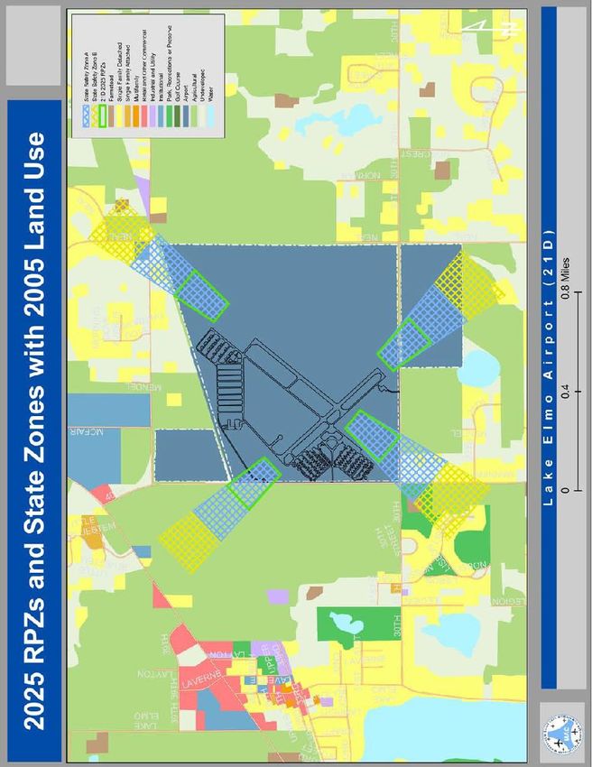
c) Airport Facilities
There are no airport facilities in West Lakeland Township except the eighty (80) acres
owned but currently unused by the Metropolitan Airports Commission adjacent to the
Lake Elmo Airport. The major part of this airport lies in Baytown Township, outside the
zoning authority of West Lakeland. The Township, furthermore, does not endorse
expansion of this facility at this time. Airport overlay, noise and safety zones also impact
the planning decisions in the Township. The Township will consider future rezoning in
other than developed residential sites in the above mentioned areas to reduce friction
between uses.
Lake Elmo Airport is a general aviation airport whose major runways trend
northeast/southwest (14/32) and southwest/northeast (4/22). Landings and takeoffs from
the northwest/southeast runway can affect residents of the Township. At present the
airport primarily supports general aviation propeller aircraft, although small jet aircraft
have used the airport.
910
Figure 3 - Lake Elmo Airport Surface Noise11
Figure 4 - Lake Elmo Airport and Overlay ZoneThe Township will comply with the Federal Aviation Administration and the Minnesota
Department of Transportation regulations restricting the height of structure that could
affect navigable airspace. The Township will incorporate provisions in its revised codes
and ordinances to control these structures.
The eastern edge of West Lakeland is adjacent to the St. Croix River. The St. Croix River
is one of 60 lakes or rivers in the metropolitan area that are designated as seaplane use
areas by MN/DOT. Lake Elmo, which lies approximately three miles west of West
Lakeland, is also designated as a seaplane use area. The Township will adopt appropriate
safety controls when land use ordinances are updated.
d) Scenic River Designation
A small portion of land in West Lakeland Township is regulated as to development by
qualifying for St. Croix Scenic River designation. The established, mandated
development ordinances are explicit as to land use both at present and in the future. These
ordinances have been adopted by the Washington County Board of Commissioners for
use throughout the County.
e) Zoning
The 1,000 foot corridor north and south of the centerline of I-94, within the Township is
currently zoned Residential/Agricultural by the Washington County Board of
Commissioners (See Figure 4). West Lakeland Township has designated this area as
commercially zoned since 1957. Under the current Township zoning ordinances this area
has been reduced considerably. Voluntary rezoning by landowners has lead to a great
deal of agreement by the County and Township on most zoning issues along I-94.
7) Surface Water Management Plan
a) PURPOSE OF THE PLAN AND SUMMARY
This Local Surface Water Management Plan will guide West Lakeland Township in
conserving, protecting and managing its surface water resources. This plan has been
created to meet the requirements detailed in Minnesota Statutes 103B and Minnesota
Rules 8410, administered by the Minnesota Board of Water and Soil Resources. This
plan is also consistent with the goals and policies of the Metropolitan Council’s Water
Resources Management Policy Plan, and the plans of the watershed management
organizations having jurisdiction within the Township.
West Lakeland Township is located within the geographic area of two watershed
management organizations (WMO’s) - the Valley Branch Watershed District and the
Middle St. Croix Watershed Management Organization (Figure 7 - Watershed
Boundaries).
12Figure 5 - Zoning Map
13Figure 6 – Wetland Inventory Map 14
Figure 7 - Watershed Boundaries

                                  15
The eastern area of West Lakeland Township drains to the St. Croix River through the
Middle St. Croix WMO. The western portion of the community drains to the Valley
Branch Watershed and from there to the St. Croix River. The plans for these WMO’s
were approved by the Minnesota Board of Water and Soil Resources (BWSR) between
2005 and 2007. Based on the completion of the watershed plans for the watershed
organizations within West Lakeland Township, the Township is required to complete this
local surface water management plan by 2008. The Middle St. Croix WMO Watershed
Management Plan will expire in 2014. The Township will need to update this LSWMP
within two years of the expiration date of its local watershed plans.
The Middle St. Croix WMO has completed a wetland inventory and management plan in
2005, including a functions and values assessment of wetlands within West Lakeland
Township and other communities in the WMO. The Valley Branch Watershed District is
currently completing the functions and values assessments and management plans for
wetlands within that District, and is estimating completion of the wetland assessment and
management plan during 2008-09.
b) Water Resource Management Agreements
The watershed organizations within West Lakeland Township have each adopted rules or
performance standards for the management of surface waters within their jurisdictions.
The Township works cooperatively with the WMO’s in communicating on development
activities, and alerts landowners and developers about potential district permits, review
processes or other enforcement. West Lakeland Township is a member of the Middle St.
Croix Water Management Organization, and has signed the Joint Powers Agreement that
created and maintains the WMO.
The Township will continue to cooperate with the Middle St. Croix Watershed
Management Organization and Valley Branch Watershed District to enforce surface
water management regulations within the community under this Local Surface Water
Management Plan.
c) Land and Water Resources Inventory
1) Surface Water Resources
a. Valley Branch Watershed District
The Valley Branch Watershed District (VBWD) drains Valley Creek, and from
the creek to the St. Croix River, an Outstanding Resource Value Water. The
Watershed District includes a number of sub-watersheds that drain to landlocked
basins (lakes or wetlands), as well as sub-watersheds that drain to Valley Creek.
The major sub-watershed districts within the VBWD that are located within West
Lakeland Township include Horseshoe Lake, Barton Pit, Mergens Pond, Rest
Area, West Lakeland Storage sub-watersheds. The Watershed also includes
numerous wetlands within the sub-watersheds.
The Watershed District has classified lakes in the District for management. The
classifications of lakes within West Lakeland Township include the following;
Horseshoe Lake and Mergens Pond as low priority. The West Lakeland Storage is
classified as a stormwater pond.
16b. Middle St. Croix WMO
The Middle St. Croix Watershed Management Plan notes that the hydrologic
system of the Middle St. Croix watershed is unique among watersheds in
Washington County in that it is not one contiguous watershed draining to one
outlet. The Middle St. Croix watershed drainage system includes two general
areas:
i. an area of small ponds, most of which are landlocked, and
ii. an area with many perennial and ephemeral streams that flow parallel to each
other and into the St. Croix River. The eastern portion of the Township is
located in the second area, including the St. Croix River bluffs. DNR
Protected Waters and Wetlands identified within West Lakeland Township is
McKean’s Pond.
2) Priority or Outstanding Water Resources
While there are no high priority lakes or trout streams within West Lakeland
Township, the wetland west of Stagecoach, south of 19th Street Court and north of the
cul-de-sac at the end of Park Avenue is considered one of highest ranking wetlands in
terms of biological diversity and the community is part of the watershed area for
Valley Branch, a designated Trout Stream. All of the Township drains to the St.
Croix River which is classified as Outstanding Resource Value Water by the State of
Minnesota.
3) Upland Resources
The pre-settlement vegetation in West Lakeland Township was dominated by oak
savanna and oak openings, with smaller areas of hardwood forest and prairies. Much
of this original vegetation has been replaced as a result of agricultural or residential
land use. Very few areas of relatively natural vegetation remain today within West
Lakeland Township. These areas were identified by the Minnesota DNR’s Natural
Heritage Program. The areas include a high grade oak savanna woodland area on the
east side of the township. Other natural and scenic resources of West Lakeland
Township include the steep topography near the lakes and St. Croix River, and the
aggregate resources in the eastern portion of the community near the St. Croix River
bluffs.
4) Groundwater Resources and Issues
Due to local soils and geology, the aquifers in and near West Lakeland Township are
highly sensitive to contamination. Most soils in the area are classified as moderate to
highly permeable, and bedrock is close to the surface in the eastern portion of the
Township, including the bluff areas near the St. Croix River. Past land use practices
have polluted groundwater aquifers in the area. A well advisory area has been
established in the Baytown - West Lakeland area. The Baytown/West Lakeland
Special Well Construction Area (SWCA) has been identified from just west of the
Lake Elmo Airport through West Lakeland Township, Baytown Township and
Bayport to the St. Croix River. The area of contamination is approximately six
square miles in size. The main source of volatile organic compounds (VOCs)
17causing groundwater contamination in the Baytown/West Lakeland SWCA has been
identified as a former metal working shop in Lake Elmo. The West Lakeland
Township SWCA is currently being monitored by the Minnesota Pollution Control
Agency. Pond levels in the area are tied to groundwater aquifers. Management of
the SWCA may affect several large ponds/wetlands.
d) Surface Water Resource Issues
1) St. Croix River
The St. Croix River is a National Wild and Scenic River, and a resource of national,
state, and local concern. Efforts to manage the water quality in the river may impact
future land use and land development activities within West Lakeland Township as
well as other communities within the St. Croix River Basin.
a. The St. Croix River Basin Planning Team identified water quality degradation of
the St. Croix River as a significant issue. Increased urbanization and agricultural
activities in the St. Croix River Watershed are predicted to lead to continued
decline in the river’s water quality. To prevent this degradation, the St. Croix
River Basin Planning Team established a goal to reduce nutrient loading to the St.
Croix River Basin by 20%.
b. West Lakeland Township will adopt and enforce the policies and performance
standards listed in section 5.0 of the MSCWMO’s 2006 Watershed Management
Plan to protect the water quality of the surface waters found within Westland
Lakeland Township and the MSCWMO. The standards include management of
surface water quality and quantity, volume control standards, and standards for
erosion control, wetland management, and bluff protection. The Township will
cooperate with VBWD in the enforcement of its rules that help to protect the
quality of the St. Croix River. The Township will also manage land use to remain
rural in character, which will help to protect the St. Croix River and its associated
bluffs and natural resources.
2) Valley Branch Watershed District
The Valley Branch Watershed District Plan identifies the following significant issues
that affect surface waters within West Lakeland Township:
• water quality degradation due to agricultural and residential land uses and
management
• potential erosion and sedimentation, and resulting pollution due to development
• current and potential flooding issues, particularly among the landlocked basins in
the District.
The Goals and Policy section of this plan identifies the specific areas in which West
Lakeland Township will contribute to the efforts to protect and improve surface and
ground water management within the Watershed District.
3) Middle St. Croix Watershed
18No priority lakes have been identified within the Middle St. Croix Watershed area.
The watershed drains through several creeks to the St. Croix River. Managing runoff,
erosion, and sediment control to minimize impacts to the St. Croix is a concern within
this watershed area. The Watershed includes numerous land-locked basins.
Managing the volume and rate of runoff to avoid flooding and impacts to these basins
are an issue of concern within the watershed. The MSCWMO Plan identifies the
following key issues for surface and ground water management within the WMO:
• Stormwater runoff impacts surface waters, particularly nutrients and other
pollutants.
• Development and urbanization may result in increased opportunities for
erosion and sedimentation. This is particularly identified in gully areas along
the St. Croix River.
• Local decision makers, land managers and the general public need education
on storm water and groundwater issues and the best ways to manage land to
protect water resources.
• Proper management of wetland resources.
• Protection of the St. Croix River.
e) Goals and Policies
West Lakeland Township will protect and manage its valuable water and natural
resources. The Township recognizes the need to work with others, including the Valley
Branch Watershed District (VBWD), Middle St. Croix Watershed Management
Organization (MSCWMO), Washington County, and the State of Minnesota to achieve
its goals for the protection of surface waters, ground water and related natural resources
within the community.
The VBWD has adopted its Watershed Management Plan and rules, and has the primary
role for enforcing surface water regulations within portions of West Lakeland Township
included in the VBWD. The Township will continue this relationship, and will support
the VBWD efforts by updating and enforcing its Zoning and Subdivision Ordinance, as
described in the goals and policies that follow. The goals and policies of this Local
Surface Water Plan listed below.
The MSCWMO has adopted its Watershed Management Plan which includes polices and
performance standards. The MSCWMO requests that its member communities update
their own ordinances for surface water management to cooperatively enforce the
MSCWMOs policies and performance standards within West Lakeland Township. The
MSCWMO Board will review projects for compliance when the following conditions
occur (see section 6.2.1 of the MSCWMO Watershed Management Plan):
Any project undertaking grading, filling, or other land alteration activities that
involve movement of earth or removal of vegetation on greater than 10,000
square feet of land.
All major subdivisions - major subdivisions are defined as subdivisions with 4 or
more lots.
Any project with wetland impacts.
Any project with grading within public waters.
19Any project with grading within the wetland buffer as identified in the plan.
Any project with grading within 40-feet of the bluff line.
Redevelopment on a site of five acres, or more, where pervious surface is
disturbed and final impervious surface, in aggregate, exceeds one acre or 5% of a
site, which causes a change in runoff characteristics, or removal of vegetation.
Development projects that impact 2 or more of the member communities.
Additionally, the following activities will trigger review by MSCWMO staff only,
but does not need full board approval:
Performance Standards in Section 5 of the WMP will apply to development within the
Middle St. Croix watershed and focus on stormwater management, erosion and sediment
control, and wetland protection. The Performance Standards will apply to all projects that
trigger the MSCWMO review process. In addition, whenever a project requires a building
permit that adds five hundred square feet of additional impervious surface or a project
requires a variance from the current local impervious surface zoning requirements for the
property, the Performance Standards will apply. Building permits for new construction in
an approved major subdivision that meets the requirements of the Performance Standards
are exempt from the water quantity and quality standards as long as the individual
property does not exceed impervious surface percentage approved for the given parcel in
that subdivision. All projects regardless of whether public or private can be reviewed.
The township will adopt and enforce the MSCWMO policies and performance standards
for surface water management within the Township areas that are part of the MSCWMO.
Goal 1:
West Lakeland Township is committed to a goal of non-degradation of the lakes,
wetlands, streams, and groundwater within the Township, and will work with local
WMO’s, Washington County and State agencies to achieve this goal.
1) Policies
a. The Township will work cooperatively with local Watershed Organizations, state
agencies and landowners to protect local wetlands, lakes, streams and
groundwater, to preserve the values of these resources for future generations.
b. The Township concurs with the Valley Branch Watershed District’s Water
Management Plan and rules and the Middle St. Croix Watershed Management
Organizations Watershed Plan, Policies and Performance Standards.
c. The VBWD will continue to enforce surface water regulations within the
Township area that is within the District’s boundaries.
d. The Township will update its Ordinance to include the MSCWMO performance
standards and requirements for stormwater management, wetland management,
and resource protection. The Township will enforce these requirements, with
review and implementation assistance from MSCWMO staff and Board. The
ordinance revisions will be completed after adoption of the Comprehensive Plan,
along with other Ordinance updates to implement the plan, and will include the
following:
• A revised erosion and sediment control ordinance that is consistent with
NPDES Construction Stormwater permit and MS4 permit requirements and
20incorporates the MSCWMO’s policies and performance standards for erosion
and sediment control.
• Wetland management requirements that include the MSCWMO’s policies and
performance standards for wetland management, buffer standards, and results
of the wetland functions and values assessment completed by the MSCWMO.
• Standards for control of peak runoff so that land-altering activities do not
increase peak stormwater flow from development sites for a 24-hour
precipitation event with a return frequency of 2, 10 and 100 years, and
encourages the use of filtration and infiltration to control runoff.
• Standards for management of stormwater quantity and quality that is
consistent with the MSCWMO performance standards. The Ordinance will
incorporate volume control standards that require retention of the first 1.0” of
runoff for all impervious areas of the site, plus 0.25” of runoff for areas with
compacted soils.
• Standards that require the use of best management practices for development
and redevelopment to reduce Total Suspended Solids (TSS) and Total
Phosphorus (TP) to 80% and 50%, respectively.
• Standards for construction will be reviewed on slopes greater than 12% and
within 40 feet of the top of bluff lines. Land alteration activities will be
reviewed within 20 feet of the top of bluff lines.
e. The Township will support the VBWD implementation of its standards for control
of peak runoff, infiltration and filtration, and best management practices to
control Total Suspended Solids (TSS), Total Phosphorus (TP), and runoff from
development or redevelopment within the Township. The District will play the
primary role in reviewing the stormwater plans for development applications
within its portion of the Township, and implement its rules through the review
and permit process. The Township will play the primary role in stormwater
permitting within the MSCWMO portion of the Township. The MSCWMO will
review applications and provide comments to the Township for these reviews.
f. The Township will manage land use to support protection of surface and ground
waters within the Township through its Zoning and Subdivision Ordinance,
including:
• Land Use Plan and Zoning Regulations
• Subdivision Regulations #131 (County ordinance)
• Shoreland Ordinance #2002-01(County ordinance)
• Floodplain Ordinance #2002-94 (County ordinance)
• Erosion and Sediment Control Ordinance
• Revision of its Stormwater Management Ordinance.
g. The Township will cooperate with the County in managing land use to protect
ground water resources.
Goal 2: Protect the quality of local lakes.
1) Policies
a. The Township supports the Valley Branch Watershed District’s goals for managing
lakes in the Township.
21b.The Township will implement its land use plan, and zoning and subdivision
ordinances to protect shoreland areas and lake water quality, and work with the
VBWD to achieve lake management goals.
c. The Township will continue to cooperate with Washington County to manage
shoreland areas under the Washington County Shoreland Ordinance, which has
been approved by the Minnesota DNR.
Goal 3: Protect wetland resources.
1) Policies
a. The Township will support the Watershed Organizations’ Wetland Management
Plans. These plans include functions and values assessments of the wetlands in
the Township, and wetland management requirements.
b. The Township will continue to contract with the Washington Conservation
District to provide wetland management services to the Township.
c. The Township supports and will adopt Watershed Management Organization
requirements for pretreatment of stormwater prior to discharge into all wetlands,
and will enforce these requirements throughout the Township.
d. The Township supports and will adopt VBWD and MSCWMO requirements for
wetland buffers based on the functions and values assessments and wetland
classifications identified in the WMO Wetland Management Plans, and will
enforce these requirements.
e. Wetlands that have not been inventoried will be required to complete a functions
and values assessment as a part of the development application. VBWD and
MSCWMO rules regarding wetland management will be applied based on the
results of the assessment and the wetland classification.
Goal 4: Protect the quality of Outstanding Resource Value Waters (ORVW), including
the St. Croix River and Valley Creek.
1) Policies
a. The Township will work with the Watershed Management Organizations and other
agencies to achieve the non-degradation goals for ORV Waters by implementing its
Zoning and Subdivision Ordinances, including new standards identified in this Plan.
Goal 5: Protect groundwater quality.
1) Policies
a. The Township will cooperate with the Minnesota Pollution Control Agency,
Minnesota Department of Health, and local watershed management organizations
to address groundwater quality issues, and enforce its Zoning and Subdivision
ordinance to protect groundwater quality.
Goal 6: Manage ground water recharge areas.
1) Policies
a. The Township will cooperate with the Minnesota Pollution Control Agency,
Minnesota Department of Health, and local watershed management organizations
to manage groundwater recharge areas.
Goal 7: Manage Inspection and Maintenance of Stormwater Facilities and Water Level
Control Structures.
221) Policies
a. The Township will develop an annual inspection and maintenance schedule of
these facilities (e.g. cleaning catch basins, trash racks, etc.) that is consistent with
MS4 requirements.
b. The township will schedule inspections for 20% of the inventoried stormwater
facilities and control structures as required by MS4.
c. The Township will develop a repair and maintenance plan upon completion of the
scheduled inspections and will implement and budget for this plan on an annual
basis. The township has no plans for future public projects and doesn't own any
facilities; therefore, the township does not have a Capital Improvement Plan.
d. The Township will street sweep annually, and when necessary, Township streets
and roads.
Goal 8: Clean-up and Contain Local Spills
1) Policies
The Township will cooperate with the Minnesota Pollution Control Agency to clean-
up and contain any reported contaminant or pollutant spill as directed by the MPCA
8) Agricultural Trends
The Township’s location near a rapidly developing metropolitan area has placed
development pressures on landowners. In addition, some residents are also using smaller
acreages for individual recreational farming. It is the Township’s intention to structure its
policies so that each farmer may have the maximum assistance in holding land for
agricultural purposes for as long as possible. With a commitment from the farmer and the
Township, preservation ordinances will be encouraged to allow continuing agricultural
practices on suitable acreage. Reasonable measures to encourage the preservation of the
agricultural land areas will be taken.
9) Land Use Plan
a) Introduction
The land use plan in the following paragraphs provides the major purposes for this
Comprehensive Plan. The environment is the most valuable resource the Township has to
offer its residents and it wishes to see the character and the quality of the land preserved.
These paragraphs provide the intent behind current land use ordinances, and serve as a
guide for making future planning and zoning decisions.
b) Existing Land Use
The major purpose of the land in West Lakeland Township is as rural residential large
lots for single family homes. Rural residential land use is defined by the Township as a
single family home on a minimum of two and one half acres. The need for public
facilities is to be kept to a minimum. These homes are to be as self-sufficient as possible
by providing on site sewer and water. private wells are permitted by Minnesota
Department of Health. A portion of the Township lies within a Well Advisory Area due
to the ground water pollution originating in neighboring community. Minnesota
23Department of Health has established special requirements for water wells located in this
area. Private on-site septic systems require soil tests and percolation studies before
Washington County will permit them. Periodic inspections and pumping of holding tanks
are also required by Washington County.
Other land uses existing in West Lakeland Township include agriculture and commercial
uses, both pre-existing, non-rural uses and compatible uses such as mining. These mining
operations provide construction material while providing income and employment
opportunities for the landowner, the Township, Washington County and the State of
Minnesota. After mining is complete, the land is reclaimed and put to its best use.
Landfills are inconsistent with a long range residential land use plan and are not
permitted. A landfill, as defined as any type of disposal facility designed for the purpose
of storing solid waste, such as, but not limited to, garbage, refuse, industrial waste, fly
ash and hazardous waste as described in the Washington County Waste Management plan
is not in harmony with the Township’s goal of a rural residential character.
Future land use will continue along these same lines. Single family homes will
predominate as they have done in the past. The Town Board, moreover, has established
the two and one half acre lot with one buildable acre as the minimum permissible lot size.
Because of the Township’s proximity to the Twin Cities, it is reasonable to conclude that
the slow residential growth as predicted by the Metropolitan Council will continue.
c) Natural Resource Areas
Important natural resources available to the township include the land itself, St. Croix
River, and numerous wetlands. The quality of the soils for residential development is
generally suitable. Constraints to building are in those areas of high or steep slopes.
While it is possible to build in these areas, consideration must be made to the limitations
of the site.
24Figure 8 - Steep Slope Areas
A final constraint to building is in the drainage ways running through the Township.
Protection of wetlands and drainage ways restrict development and are important to the
Township when development plans are reviewed. Where easements for the surface water
management are obtained by, but not limited to, the following organizations: Valley
Branch Watershed, Middle St Croix Water Management Organization, and Washington
County.
d) Aggregate Resources
Dolomite aggregate is considered to be a valuable resource, and is encouraged to be
mined where economically feasible and no current conflicting land use, such as area
recreation or existing residences, exist. Mining is managed through conditional use
permits in all residential zones. Existing mining operations will be encouraged to be
retained for as long as economically viable. Most of the land suitable and economical to
mine is already owned by mining companies. Only four undeveloped areas of the
Township remain as possible mining locations and each of these may have problems
developing. All other are either developed or previously had the gravel extracted.
e) Land Use Policies and Plan
The Township is primarily to be a rural residential zoning district, along with small
commercial areas. This zoning classification allows single family homes on two and one
half acres with one acre buildable and with 160 feet of frontage on a public road. The lots
25are to be created when described by platting or simple subdivision to Washington County
and West Lakeland Township standards.
Lots will be permitted only if soil tests show that the particular parcel will be able to
maintain on-site sewage disposal system for the foreseeable future. When soils are not
suitable or other constraints (such as surface water management) are encountered, larger
lots may be required.
Appropriate land development must not aggravate water surface runoff or flooding
problems within the lot or to neighbors. Appropriate development will also provide
adequate buildable lots, properly constructed, hard surfaced public roads, utility and
drainage easements, and buried utilities. Subdivision and development ordinances have
been and will continue to be adopted to ensure the attainment of these goals. West
Lakeland’s intent is to provide an opportunity for resident landowners to provide a single
site for a property owner to provide a residence for himself and his family while
protecting, preserving and even enhancing the rural environment and lifestyle.
The responsibility for creating a buildable lot lies with the developer of the site, not the
purchaser or the Township. The specifications for a plan and any individual lots are
provided in the Township codes.
The current zoning ordinance affords additional protections for increasingly larger
parcels of at least five or more acres and permits a degree of livestock and other
agricultural practices consistent with what might be considered appropriate for hobby
farming. These provisions are granted by Township zoning ordinances.
A second level of protections can be secured voluntarily and unilaterally by the
landowner, from the Township, with the objective on the part of the Township to be
officially supportive and to encourage agricultural, open space, and conservation
practices. A commitment of the landowner to these community goals brings a return
commitment from the Town Board to help the landowner continue these agricultural
practices. This type of land use may also keep the property eligible for “green acres” tax
consideration.
A final level of protection, separate, but granted on a similar voluntary, individual basis
by the community, is the Agricultural Preserves Program. Parcels of forty or more acres
in size can qualify for state agricultural preserve benefits providing the requirements of
the state statutes are met and certified to the Township clerk.
The method of assigning the appropriate zoning and land use to the parcel of land will be
a process of conditional use permits that extends and defines the acceptable use beyond
rural residential limits. The commitments and obligations of each party are detailed in the
specific conditional use obligations of each party are detailed in the specific conditional
use permit. Rather than granting these benefits to outlined areas of the Township, the
Town Board has chosen to grant these land use variations through the conditional use
permit process by individual parcel application. This allows the legal and economic
26protections offered to the maximum number of residents and at the same time, ensures a
guarantee of a maximum of open space and agricultural land for as long a time as
possible
The Township’s goal is to encourage and preserve the rural open space nature of the area
despite a growing population and additional development. Since the Township does not
plan to expand public services, an individual allotment process can prove beneficial to all
concerned. A system of permits would allow each case to be considered on individual
merit and suitability.
Within the small commercial areas some of the allowed uses in the Neighborhood
Commercial Zone with a conditional use permit include, but not limited to, bakeries,
banks, office buildings, drug stores, arts and crafts stores, government buildings, florists,
and coffee shops. Some of the allowed uses within the Highway Commercial Zone with
a conditional use permit include, but not limited to, convenience food stores, government
buildings, car washes, physical fitness centers, and restaurants. The uses are allowed
through a conditional use permit to ensure the best fit with the residential community,
which is always in close proximity to all commercial activities.
2728
Figure 9 - Possible Mining AreaFigure 10 - Present Land Use
29Figure 11 - Future Land Use 30
f) Land Use Summary
     The most important use of land in the Township now and in the future is to provide
     homes for residents and their families. Some future commercial development will provide
     more jobs for residents within our own community. Home occupations, through properly
     granted conditional use permits, will provide some of this economic opportunity. People
     are important, and the land use plans are devised so that each resident may make the
     maximum use of the land while preserving its character and rural atmosphere for the
     whole community. Innovation and individuality are important when developing land
     within these guidelines.

     At present there exists approximately 1,400 acres of agricultural or underdeveloped land
     within the residential acres of West Lakeland Township, with an additional 500 acres
     designated for mining to take place in the near future. These estimates include 50 small
     minor subdivisions (lot splits). At an average estimated lot size of 4 acres (4 acre average
     lot size is used to due steep terrain, wetlands, and additional necessary roads in remaining
     areas.) this would leave approximately 525 residential home sites available. At present
     development rates, this would leave the Township fully developed by the year 2020.
     These estimates are based on approximately 480 acres being developed other than
     residential (i.e. public, semi-public, or commercial uses). In addition, these estimates are
     based on maximum development, and do not include those properties which could remain
     underdeveloped, (i.e. agricultural or large estates).

10) Housing Plan
  The existing housing stock consists of moderately aged to new homes for housing a single
  family, most are resident owners. Currently, there are 1,200 households in the Township;
  with the current development trend, the Township should reach full development within the
  next 20 years. Rental housing is minimal in the Township. There is no public housing
  planned in as much as the Township classifies this as an urban public service, not in keeping
  with the rural nature of the Township. Moreover, the Township does not plan to provide the
  services needed to sustain a workable public housing system. The Township is, and is wishes
  to be, a quiet, rural community.

  1990, and 94% since 1960. Housing values are above the area average, and residents take
  pride in their homes and maintain them with care. The Town employs a building inspector
  who, along with the Township Board, monitors the condition of the housing stock. Universal
  building codes have been adopted to ensure quality housing stock.

  The Building Inspector or Township Board investigates complaints and takes appropriate
  course of action. Current methods of addressing these complaints have been satisfactory.

  The Township Board in no way limits or restricts home rehabilitation loans and/or grants to
  be made to its low or moderate income residents through the Washington County HRA
  and/or local lending institutions.

                                                                                              31
11) Public Facilities Plan
The rural self-sufficient nature of the Township is interpreted as meaning the Township will
allow the residents to provide for themselves as much as possible. Some basic services,
however, are necessary in any town or community, such as roads, road maintenance, and
arrangements for police, fire protection, and emergency medical services.
Other services, however, are unnecessary for the lifestyle established in the community.
These services are more than can be expected in a rural environment. It is the Township’s
intention to delay the provision of these services as long as possible, if providing them at all.
Specific services are addressed in the following sections.
12) Transportation Plan
The existing transportation facilities consist of a network of public roads with one Interstate
Freeway, one State Highway, five County collector routes, and various Township roads
connecting the developments and residences. Interstate 94 passes through the Township in an
east/west direction serving commuter traffic to and from St. Paul. All of the public roads are
paved and it is required by ordinance that roads now built as part of a plat or subdivision be
paved and prepared to County and Township standards and deeded to the Township. The
Township has no intention to construct roads on its own initiative.
The major purpose of the roads in the Township is to serve the residents by connecting them
with major thoroughfares and neighboring urban centers. The Township roads are maintained
at Township expense. There has been an ongoing effort to locate development off these
major thoroughfares in the interest of safety and aesthetics.
Since creation of this plan, the Township has developed a partial road plan that shows
possible future extensions of Township roads. This map is intended as a guide for some, but
not for all, future local road connections.
The road system in West Lakeland Township includes several different functional classifications.
Interstate 94 is a Principal Arterial, and one of the heaviest traveled roads in the Metropolitan area.
Highway 36, another Principal Arterial, runs east/west about three miles north of the Township.
Principal Arterials are generally the most heavily traveled roads in the area; they are designed to
carry longer trips at higher speeds with minimal local access. With the exception of Interstate 94
and Manning Avenue, all roads in the Township are two lanes.
West Lakeland also includes two types of “A” minor arterials; County Trunk Highways 10 and 21
are designated as expanders, which are intended to provide through traffic for areas with
development. County Trunk Highway 15, running along the west edge of the Township and State
Trunk Highway 95, running along the east side of the Township, are both connectors, roads
intended to link cities outside the developed area. The Township Road Network is considered
by the Township as a single Traffic Analysis Zone (TAZ), a subset of the I-94 East TAZ
identified by the Metropolitan Council.
32Figure 12 – Recommended Street Spacing for IRCs
33Figure 13 – Recommended Street Spacing for Non-IRCs 34
TAZ Forecasts for West Lakeland Twp
                                               (As of December, 2009)

                                                           POPULATION                        HOUSEHOLDS                      TOTAL EMPLOYMENT

                                               TAZ         2000         2010   2020   2030   2000    2010    2020    2030    2000   2010   2020
                                                          2030

                                               1114        795          864    890    955    244     280     310     340     0      40     40     40
                                               1195        1,406        1536   1570   1655   451     530     555     600     0      10     10     10
                                               1196        1,346        1460   1490   1580   406     480     535     570     313    40     40     50

                                               Totals      3,547        3860   3950   4190   1,101   1,290   1,400   1,510   313    90     90
                                                          100

                                                           RETAIL EMPLOYMENT                 NON-RETAIL EMPLOYMENT

                                               TAZ         2000         2010   2020   2030   2000    2010    2020    2030

                                               1114        0            0      0      0      0       40      40      40
                                               1195        0            0      0      0      0       10      10      10

     Figure 14 – TAZ Forecasts West Lakeland
                                               1196        25           25     25     25     288     15      15      25

                                               Totals      25           25     25     25     288     65      65      75

35
Figure 15 – TAZs in West Lakeland 36
Figure 16 - Road Jurisdictional Map
                                      37
Figure 17 - Future Road Plan 38
The principal arterials and the minor arterials in the Township should be sufficient to handle
  existing and future development within the Township for the next twenty years, since the majority
  of the Township is already developed. The Metropolitan Council’s Regional 2030 Transportation
  Policy Plan indicates that as of 2030, there are no congested highways in the Township. The plan
  does indicate congestion on I-94, and marks it as medium-high for operating priority and park and
  ride priority, and as a high priority Interregional Corridor.

  The Township will work with the State of Minnesota and Washington County to assure that Minor
  Arterials in the Township are protected and upgraded as needed to handle additional traffic.

  The existing bicycle/pedestrian path, located on the north side of I-94, is available for general all
  purpose bicycling. It is maintained and regulated the State of Minnesota Dept. of Transportation.
  The township has no present plans to extend or expand the path or add additional paths.

  a) Access Management
      West Lakeland Township works with Washington County to regulate the number of access
      points to the County roads and with MDOT regarding access onto State and U.S. Highways. In
      order to promote a safe and efficient transportation system, spacing and access guidelines are
      incorporated into the Townships subdivision regulations. Guidelines describe access spacing
      on principle arterials, minor arterials, collectors and local roads. The land use associated with
      proposed access points also determines the appropriate spacing.
  b) Transit
      West Lakeland Township is outside of the Metropolitan Transit Taxing District. Therefore,
      there is no regular route transit service existing or planned for the Township. The Township is
      in Market Area IV. Service options for Market Area IV include dial-a-ride, volunteer driver
      programs, and ridesharing. Rural dial-a-ride service is provided by Human Services Inc.

13) Sanitary Sewer Plan
  Existing sewage facilities consist of an on-site septic system for each residence. All of the
  residences currently in the Township are thus served with very minor difficulties. These
  difficulties are not due to failure of the ground, but failures of the construction or antiquated
  systems being repaired by the homeowner. The Township will continue with this method of
  service on its minimum two and one half acre lot with the understanding that “buildable” is
  to include a guarantee that a proper onsite septic system can be installed to meet community
  requirements as specified in building ordinances. It is also noted by West Lakeland’s Town
  Board that the Metropolitan Council, at this time, does not wish to extend the MUSA lines
  into the Township. By permitting construction only with appropriate sewage systems on site,
  the community will limit the need for such services.

  There were approximately 1,200 individual sewage treatment systems in the Township in
  2006. The Township recognizes the need to monitor not only the new systems that are
  installed, but also existing systems. In order to comply with State Rules Chapter 7080 and to
  protect the groundwater resource, the Township has entered into an agreement with
  Washington County whereby Washington County and West Lakeland Township have
  cooperatively developed an ISTS (Individual Sewage Treatment Services) Management

                                                                                                          39
You can also read