Central Place and Liminal Landscape in the Territory of Populonia - MDPI
←
→
Page content transcription
If your browser does not render page correctly, please read the page content below
land
Article
Central Place and Liminal Landscape in the Territory
of Populonia
Giorgia Maria Francesca Di Paola 1,2
 1   Department of Historical Science and Cultural heritage, University of Siena, Via Roma n. 56,
     53100 Siena, Italy; giorgiadipaola@hotmail.com
 2   Department of Humanistic Studies, University of Foggia, Via Arpi n. 176, 71121 Foggia, Italy

 Received: 2 July 2018; Accepted: 29 July 2018; Published: 3 August 2018

 Abstract: This article aims to outline new data on the urbanization of Populonia starting from
 its foundation, with particular reference to the results of archaeological surveys carried out by
 the University of Siena since the 1980s. The landscape archaeology approach has allowed us to
 reconstruct the Etruscan city’s organization of settlements as well as its management of resources.
 In addition, this investigative tool has proven the most effective method to detect both places of
 economic or ideological centrality and specific liminal landscapes in the territory of Populonia.
 The urban development of the Etruscan city represents an anomalous case for several reasons that
 are mainly dependent on its shape, which required unconventional choices in the organization and
 management of its territory and natural resources. Our research leads us to suggest that the Etruscan
 city’s acropolis seems to have played the role of central place starting right from the establishment of
 the city. Within some of the new acquisitions coming from my PhD research we have to consider the
 feature of the hilltop fortresses system and the detection of a “liminal landscape” in the northeastern
 stretch of the territory between Populonia and Volterra. This particular part of the landscape had
 been a sacred district with a strong peripheral character and possibly close connections to the central
 place thanks to the significant availability of natural resources.

 Keywords: landscape archaeology; Populonia; settlement organization; supply basin; central place;
 hilltop fortresses; liminal landscape; connectivity; viewshed analysis; sacred areas

1. Introduction
      This paper aims to outline some of the most important phases of Populonia’s urban development
starting from its foundation, with particular reference to the results of archaeological surveys carried
out by the University of Siena since the 1980s. My new data on the urbanization of Populonia is
one of the most significant results of my PhD research project focused on the development of the
Populonia frontier and territory with respect to the neighboring Etruscan centers of Volterra to the
north, and Vetulonia and Roselle to the south. To pursue this goal, I reconstructed both the organization
of the settlements and the management system of resources applied by Populonia on the longue durée,
moving from the Late Bronze–Early Iron Age to the Hellenistic period. In this paper, I concentrate on
the period between the 6th century BC to the 3rd century BC, before Populonia was incorporated into
the Roman Empire.
      From this point of view, my PhD research could be included in the general branch of knowledge
concerning the definition of the political and ethnic frontiers between one or more communities.
Although the human need to establish cultural-group borders already existed long before, it was only
starting from the end of the 19th century that the frontier became a subject of study. Some scholars
investigated this field by making historical border reconstructions, within the context of military
interests of colonialism and nationalism politics [1] (p. 23). F. J. Turner, on the contrary, studying

Land 2018, 7, 94; doi:10.3390/land7030094                                          www.mdpi.com/journal/land
Land 2018, 7, 94                                                                                     2 of 16

the frontier in American history, interpreted it entirely as free lands to colonize, taking no interest
in indigenous people living there [2]. From the 1950s, when most European colonies gained their
independence, some scholars, such as Owen Lattimore, considered the frontier as the area of interaction
between people from different cultures [3]. The scientific debate of the 1970s saw the predominance
of both the core–periphery model and the emergence of the world system theory [4], well-suited to
explain the hierarchical organizations of trade connections in the world. In terms of archaeological
perspective, this system was the first theoretical model that tried to explain the influence of the contacts
between different communities on promoting cultural changes in specific ethnic groups [5–7]. During
the last two decades of the 20th century, some areas of research highlighted an idea of the frontier as
a permeable meeting zone and cultural exchange area depending both on the flexibility of the political
authority and the elasticity of its territorial control [8,9].
      Although political frontiers can be considered some of the most visible evidence of ethnic identity
in pre-Roman central Italy, my study specifically deals with political frontiers on the sub-regional
level [10]. As G. Cifani, L. Ceccarelli and S. Stoddart note, “In pre-Roman Etruria, as a general rule,
we can say that frontiers take a number of forms depending on the configuration of the power centers,
the physical circumscription of the area and the topography of the landscape” [10] (p. 164).
      The need to study and define the territorial limits of specific communities requires the interaction
with other scientific approaches, such as spatial archeology and landscape archaeology, specifically
to understand the ways in which people in the past constructed and used the environment around
them. The first approach encourages the application of both modern geographic-economic models and
statistics to archaeological evidence in order to interpret site distributions in the landscape [11] (p. 9).
Among the most interesting interpretative models, we have to mention: (1) the Early State Module,
applied at first to Mycenaean Greece state societies, then to Etruscan cities [12] (pp. 3–59); this method
was recently implemented by the XTENT model that permits variations in the size of territory, also
evaluating the “friction” of the physiography of the landscape [13]; (2) the Thiessen Polygon Method,
to describe settlement patterns based on territorial divisions centered on a single site or feature; (3) the
peer polity interaction to explain change in society and in material culture [14]. A recent update is
also the landscapes of power theory that aims to develop analytical models to simulate and study
political arrangements of ancient territories. This approach intersects various disciplines, such as social
archaeology, anthropology and geography [15–17].
      Landscape archaeology is an area of study that surpasses the conventional boundaries between
disciplines and provides a fresh perspective and a powerful investigative tool to address research
questions related to the conscious and the unconscious shaping of the land and the process of
organizing space, involving interactions between the physical environment and human presence.
      Landscape is never inert: people are directly associated with it, rework it, appropriate it and
contextualize it [18] (p. 3). As Ashmore notes, “prominent among the meaning of landscape are power
and identity, variously defined and expressed in sundry forms” [19]. As landscape delineates memory
and declares identity, the land itself plays a fundamental role in social-cultural order and in human
relationship [20]. Furthermore, “as a community merges with its habitus through the actions and
activities of its members, the landscape may become a key reference point for expressions of individual,
as well as group, identity” [21].
      Thus, the methodological approach chosen to carry out the detection of Populonia frontiers and
the development of its territory was basically multidisciplinary and it derived from: (1) a detailed
collection of records and knowledge coming from different sources, such as archive documents,
historical and epigraphic sources, as well as archeological and geological data; and (2) the setting-up
of a specific geographic information system, capable of storing, managing and analyzing the different
kinds of data and displaying them on a map.
      Since the 1980s, thanks to the results from archaeological surveys carried out by the University
of Siena, research on the territorial organization of Populonia has improved and the landscape
archaeology approach, as a whole, has shown itself to be the most effective method of identifying the
Land 2018, 7, x FOR PEER REVIEW 3 of 16
Since
Land 2018, 7, 94the
1980s, thanks to the results from archaeological surveys carried out by the University 3 of 16
of Siena, research on the territorial organization of Populonia has improved and the landscape
archaeology approach, as a whole, has shown itself to be the most effective method of identifying the
structural
structuralcontext
contextofofPopulonia
Populonia(Figure
(Figure1).
1). The
The detection
detection of of aaspecific
specificliminal
liminallandscape
landscapeasaswell
well
asas
thethe
feature of the hierarchical fortified system are some of the new data coming from my
feature of the hierarchical fortified system are some of the new data coming from my PhD research. PhD research.
They
Theyalso
alsocontribute
contributetotorecognize
recognizePopulonia’s
Populonia’splaces
placesofofeconomic
economicor orideological
ideologicalcentrality
centralityas
aswell
well as
as to
re-evaluate “marginal
to re‐evaluate landscapes”
“marginal landscapes”in the surrounding
in the surrounding territory.
territory.
Figure1. 1.General
Figure Generalmap
mapofof archaeological
archaeological surveys
surveys in
in the
the territory
territoryof
ofPopulonia
Populoniaundertaken
undertakenbyby
the
the
UniversityofofSiena
University Sienasince
since1980s.
1980s.
2. The Birth of Populonia in the Early Iron Age and its Urban Development
2. The Birth of Populonia in the Early Iron Age and its Urban Development
The urban development of Populonia represents an anomalous case for several reasons that are
The urban development of Populonia represents an anomalous case for several reasons that
mainly dependent on its shape, which required unconventional choices in the organization and
are mainly dependent on its shape, which required unconventional choices in the organization and
management of its territory and natural resources [22] (Figure 2).
management of its territory and natural resources [22] (Figure 2).
Firstly, Populonia was the only Etruscan city that was directly on the coast. It occupied the hills
Firstly, Populonia was the only Etruscan city that was directly on the coast. It occupied the hills of
of Poggio del Telegrafo and Poggio del Castello and overlooked the Gulf of Baratti. During the 5th
Poggio
centurydel BC,
Telegrafo
whenand thePoggio del Castello
territory and overlooked
of Populonia reached the its Gulf of Baratti.
maximum During the
expansion, it 5th century
stretched
BC, when the territory
approximately from of Populoniatoreached
Donoratico its maximum
the north and the Alma expansion,
river toit stretched
the southapproximately
of the Piombino from
Donoratico to the north and the Alma river to the south of the Piombino headland
headland [23]. In ancient times the landscape was very different: there were many coastal lagoons [23]. In ancient times
the landscape
that, was very
particularly in thedifferent:
Piombino there were
area, many
made thecoastal
headlandlagoonsinto that, particularly
a particular kindinofthe Piombino
peninsula
area, made
[24,25]. ThethePopulonia
headlandsurrounding
into a particular kind ofvaried:
was highly peninsula
it was[24,25]. The Populonia
characterized surrounding
by a succession was
of hills
highly varied: it was characterized by a succession of hills and flat lands,
and flat lands, by the presence of hot sulphur springs and was traversed by many rivers. Thus, the by the presence of hot
sulphur springs from
city benefited and was traversed
a territory by great
with manypotential,
rivers. Thus,richthein city benefited
natural fromThe
resources. a territory
coastal with great
lagoons
potential, rich in natural
served numerous resources.
functions: The coastal
they supplied lagoons food
fundamental served numerous
resources, for functions: they
instance, here supplied
fish were
fundamental
farmed andfood salt resources,
produced;fortheyinstance, here fish
provided werefor
harbors farmed and salt produced;
medium‐size boats; theythey provided
served as
protective‐climate
harbors for medium-size areasboats;
during
theywinter
servedgrazing along the transhumance
as protective-climate areas during routes and during
winter grazing along
cultivation
the transhumancecyclesroutes
of grainandand trees [26,27].
during In addition
cultivation cycles oftograin
this formidable food supply,
and trees [26,27]. Populonia
In addition to this
formidable food supply, Populonia could draw on other resources in the form of mixed sulphides and
iron ore extracted from the quarry of the Campigliese district and the Island of Elba, as well as the
Buca delle Fate site.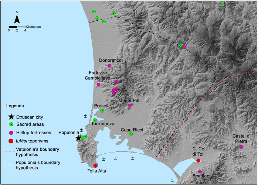
Land 2018, 7, x FOR PEER REVIEW                                                                          4 of 16

could
Land   draw
     2018, 7, 94on other resources in the form of mixed sulphides and iron ore extracted from the quarry
                                                                                                   4 of 16
of the Campigliese district and the Island of Elba, as well as the Buca delle Fate site.

          Figure
          Figure 2.
                 2. Populonia:
                    Populonia: the
                               the acropolis
                                   acropolis site.
                                             site. The
                                                   The Early
                                                       Early Iron
                                                             Iron Age
                                                                  Age Poggio
                                                                      Poggio del
                                                                             del Telegrafo settlement.
                                                                                 Telegrafo settlement.

     Secondly, there are not many literary sources about Populonia, but one of the most interesting
     Secondly, there are not many literary sources about Populonia, but one of the most interesting
legendary traditions is referred to by the Late Antiquity writer Servius, who indicated Populonia as
legendary traditions is referred to by the Late Antiquity writer Servius, who indicated Populonia as
the last city founded among the Etruscan centers; he also suggested three possible provenences of
the last city founded among the Etruscan centers; he also suggested three possible provenences of the
the founders: as settlers from Corsica, or from Volterra, or as a group that forced out a previous
founders: as settlers from Corsica, or from Volterra, or as a group that forced out a previous community.
community. Although this source is not easily verified, the hypothesis of a close relationship
Although this source is not easily verified, the hypothesis of a close relationship between the Island of
between the Island of Corsica and Populonia might be deduced from the analogies of specific
Corsica and Populonia might be deduced from the analogies of specific material culture and funerary
material culture and funerary practices during the 9th and the 8th century BC [28]. It is significant
practices during the 9th and the 8th century BC [28]. It is significant that the same analogies can also
that the same analogies can also be identified in the Iron Age material culture, including both
be identified in the Iron Age material culture, including both imported and imitation goods [29] as
imported and imitation goods [29] as well as funerary practices from Sardinia and the Island of Elba.
well as funerary practices from Sardinia and the Island of Elba. Some rituals present here have been
Some rituals present here have been directly attributed to Sardinian and Corsican influences: for
directly attributed to Sardinian and Corsican influences: for instance, the early adoption of burial
instance, the early adoption of burial rituals and the practice of burying a group of people in caverns
rituals and the practice of burying a group of people in caverns or natural clefts spread throughout the
or natural clefts spread throughout the Island of Elba and is well attested in the Riparo Biserno site
Island of Elba and is well attested in the Riparo Biserno site (San Vincenzo-Livorno). A high level of
(San Vincenzo‐Livorno). A high level of connectivity must have linked these local communities.
connectivity must have linked these local communities. Thus, it is likely that the maritime trades in
Thus, it is likely that the maritime trades in this part of the Tyrrhenian Sea were controlled by clan
this part of the Tyrrhenian Sea were controlled by clan families who lived in Populonia, and on the
families who lived in Populonia, and on the Islands of Elba, Corsica and Sardinia. The situation
Islands of Elba, Corsica and Sardinia. The situation could also be proved by the lack of material culture
could also be proved by the lack of material culture coming from areas external to this specific trade
coming from areas external to this specific trade network [30]. In the late Iron Age, Vetulonia took part
network [30]. In the late Iron Age, Vetulonia took part in this trade network, too and it seemed to be
in this trade network, too and it seemed to be in competition with Populonia [31] (p. 286). The Island
in competition with Populonia [31] (p. 286). The Island of Elba, in all probability, was included in the
of Elba, in all probability, was included in the Populonia dominions at least from the Early Iron Age,
Populonia dominions at least from the Early Iron Age, if not before [32]. The Villanovan Populonia
if not before [32]. The Villanovan Populonia appears to be the hub of a geographical district rich in
appears to be the hub of a geographical district rich in resources and not only as a crucial junction of
resources and not only as a crucial junction of Tyrrhenian passage but also of the main Mediterranean
Tyrrhenian passage but also of the main Mediterranean routes [22].
routes [22].
     Thirdly, the growth of Populonia seems to differ slightly from the “city‐territory” model, or
     Thirdly, the growth of Populonia seems to differ slightly from the “city-territory” model,
urbs‐ager, based on the city’s prevalent role over its countryside. Populonia appears closer to the
or urbs-ager, based on the city’s prevalent role over its countryside. Populonia appears closer to the
example of some Magna Grecia colonies’ territorial evolutions, such as Metaponto [33],
example of some Magna Grecia colonies’ territorial evolutions, such as Metaponto [33], characterized
characterized by a strong dualism of the political center on the acropolis and the surrounding lands.
by a strong dualism of the political center on the acropolis and the surrounding lands. This duality
This duality is highlighted by the analysis of the relationship that the city established with its supply
is highlighted by the analysis of the relationship that the city established with its supply basin [26]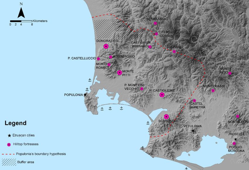
Land 2018, 7, 94 5 of 16
Land 2018, 7, x FOR PEER REVIEW 5 of 16
(p. 73). In the Late Bronze Age, the top of the Piombino headland was unpopulated. By contrast,
basin [26] (p. 73). In the Late Bronze Age, the top of the Piombino headland was unpopulated. By
many small settlements appeared along the coastline and in the Campigliese district. Based on
contrast, many small settlements appeared along the coastline and in the Campigliese district. Based
our current knowledge, the biggest coastal settlement was located on Poggio del Molino: we can
on our current knowledge, the biggest coastal settlement was located on Poggio del Molino: we can
probably
probablylinklinkthe
theVilla
Villadel
delBarone
Barone necropolis
necropolis toto this
thissite,
site,which
whichwas wasfound
found less
less than
than 500500 m away
m away [34].[34].
Revealed through chance archaeological finds, the other coastal sites—Villa
Revealed through chance archaeological finds, the other coastal sites—Villa Salus [35], Riva degli Salus [35], Riva degli
Etruschi
Etruschi[36]
[36](pp.
(pp.123–124),
123–124),LaLaTorraccia
Torraccia[36]
[36](p.(p.125),
125),Centro
CentroVelico/Casone
Velico/Casone[37] [37]and
andTorre
TorreMozza
Mozza[36]
(pp.
[36] (pp. 125–126)—could be interpreted as small specialized manufacturing settlements. Theonly
125–126)—could be interpreted as small specialized manufacturing settlements. The onlysite
wesite
canwebecan
surebe of, in of,
sure terms of itsofkind
in terms of manufacturing
its kind of manufacturing activities, is the
activities, Centro
is the Centro Velico/Casone
Velico/Casonesite
where salt was
site where saltextracted [31]. [31].
was extracted In the InCampigliese
the Campigliese district, richrich
district, in mixed
in mixed sulfides
sulfidesand iron
and ore,
iron the
ore, sites
the
had thehad
sites specific functionfunction
the specific of controlling miningmining
of controlling activity:activity:
a clear aexample is the Vallin
clear example is thedel Mandorlo
Vallin del
Mandorlo[38]
settlement settlement
(Figure[38]
3). (Figure 3).
Figure3.3.GIS
Figure GISgeneral
generalmap
map of
of Populonia’s
Populonia’s settlement
settlementdistribution
distributionduring
duringthe Late
the Bronze
Late Age
Bronze andand
Age thethe
Early Iron Age.
Early Iron Age.
In the Early Iron Age, the area of the historical city, corresponding to Poggio del Telegrafo and
In the
Poggio Early
del Iron Age,
Castello, the area ofby
was populated thea historical
communitycity, corresponding
with evident statustomarkers
Poggio anddel Telegrafo
segmentedand
Poggio del Castello,
into family clans, as was populateddata
archaeological by asuggest
community withsite
[39]. This evident statusbecause
was chosen markers of and segmented
its dominant
into
andfamily clans,
naturally as archaeological
defensible data suggest
position overlooking [39]. Thisterritory,
neighboring site was thechosen
port,because
the Gulfof ofits dominant
Baratti as
and naturally defensible position overlooking neighboring territory, the port,
well as the ancient coastal lagoons and the Island of Elba and, with good weather conditions, the the Gulf of Baratti
asIsland
well as of the ancient
Capraia andcoastal lagoons
Cape Corse [40].and
Thethe
timeIsland
periodof of
Elba
the and,
city’swith
earlygood weather seems
development conditions,
to
correspond
the to the abandonment
Island of Capraia and Cape Corse of the LateThe
[40]. Bronze
time Age settlements
period along
of the city’s the development
early coastline. Although
seems to
archaeological
correspond evidence
to the is lacking,
abandonment ofsome argument
the Late Bronze forAge
this settlements
interpretation can be
along themade at leastAlthough
coastline. for the
archaeological evidence is lacking, some argument for this interpretation can be made at least this
Gulf of Baratti area, where the necropolis overlaps the previous settlement. It is possible to relate for the
phenomenon
Gulf to thewhere
of Baratti area, simultaneous concentration
the necropolis overlapsof the
the previous
population in the historical
settlement. city area,
It is possible as partthis
to relate
of a larger commitment
phenomenon to planning,
to the simultaneous which also involved
concentration the gulf [22]in
of the population (p.the
61).historical
The arrangement
city area,ofasthepart
Early Iron Age necropolis was anomalous in comparison with other Etruscan
of a larger commitment to planning, which also involved the gulf [22] (p. 61). The arrangement cities, such as Veio,
ofTarquinia,
the Early Cerveteri
Iron Age and Vulci, where
necropolis the funerary
was anomalous in areas entirely with
comparison enclosed
otherthe settlements
Etruscan [41]
cities, (p. as
such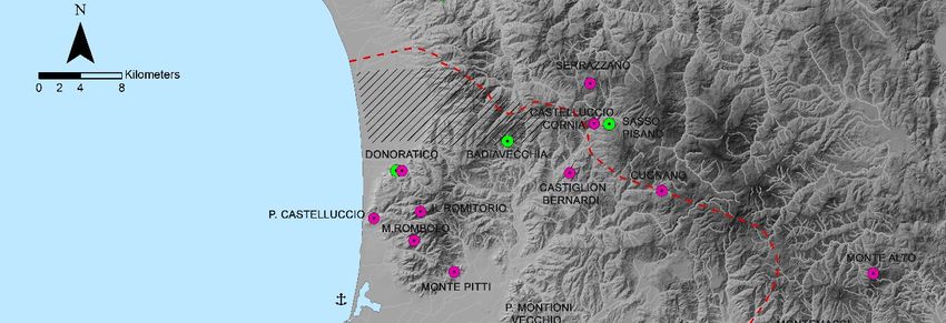
Land 2018, 7, 94 6 of 16
Land 2018, 7, x FOR PEER REVIEW 6 of 16
Veio, Tarquinia, Cerveteri and Vulci, where the funerary areas entirely enclosed the settlements [41]
(p. 105). Because of the particular shape of the ancient coastal landscape, the necropoli were laid
105). Because of the particular shape of the ancient coastal landscape, the necropoli were laid out on
outtheon the most
most unencumbered
unencumbered areas areas
facingfacing the of
the Gulf Gulf of Baratti
Baratti and Populonia
and thus thus Populonia was surrounded
was surrounded by
bythemthem [22] (pp. 66–68). While the proto-historic settlements were almost
[22] (pp. 66–68). While the proto‐historic settlements were almost completely abandoned, completely abandoned,
the
the small
small Campigliese
Campigliese sites
sites persisted
persisted and and controlled
controlled mining
mining activities
activities [42],
[42], establishing
establishing thethe great
great
dualism
dualismbetween
betweenthe theacropolis
acropolis site
site and
and thethe resources
resourcesof ofthe
theneighboring
neighboringcountryside.
countryside. It It
is is
notnot always
always
clear whether the urban acropolis site was more influential on the chora, endowed
clear whether the urban acropolis site was more influential on the chora, endowed with a variegated with a variegated
supply
supplybasin,
basin,ororififthe
theopposite
opposite [26]
[26] (pp. 73–74)
73–74) was
wastrue.
true.InInspite
spiteofofsparse
sparsearchaeological
archaeological data
data after
after
itsitsestablishment,
establishment, Populonia
Populonia promoted
promoted aa hierarchical
hierarchicalsettlement
settlementsystem,
system,centered
centered onon a network
a network of of
sites
sitesand
andononthethe
foundation
foundation of new
of newpopulation centers,
population in keeping
centers, with most
in keeping with of the of
most Southern Etruscan
the Southern
cities. In this
Etruscan respect,
cities. In this the common
respect, the burial
common ground
burialatground
the Riparo Biserno
at the Riparosite (Livorno)
Biserno and the Monte
site (Livorno) and
the necropolis
Pitti Monte Pittiare necropolis are relevant
particularly particularly relevant
during during
the Iron Age.the Iron
The Age.
first, The with
joined first, the
joined with the
archaeological
archaeological
evidence from theevidence from the small
small Campigliese Campigliese
sites, proves the sites, proves of
existence theaexistence
network of of aminor
network of minor in
settlements
settlements in charge of mining activities [22] (Figure 4). Even without knowing
charge of mining activities [22] (Figure 4). Even without knowing which settlements were tied to the which settlements
were tied
Monte Pittito the Monte
burial ground, Pitti
weburial ground,
can still presumewe can
thatstill presume
it had that itinhad
been sited been sited
a strategic in a strategic
position, probably
position, probably to control access to the Campigliese mineral basin. All
to control access to the Campigliese mineral basin. All of these evidence-based considerations lead of these evidence‐based
usconsiderations
to presume that, leadstarting
us to presume
from thethat, starting
Early Ironfrom
Age,the theEarly Iron Age,
acropolis the acropolis
settlement can besettlement
considered canthe
be considered the central place: the community living there represented a
central place: the community living there represented a catalyst for employing resources from both the catalyst for employing
resources from
Campigliese bothand
district the Campigliese
the surrounding district and the
supply surrounding supply basins.
basins.
Figure4.4. GIS
Figure GIS general
general map
map of
of Populonia’s
Populonia’s settlement
settlement distribution
distributionduring
duringthe
theend
endofofthe
the9th/the
9th/the
beginning of the 8th century BC and the first half of the 7th century
beginning of the 8th century BC and the first half of the 7th century BC.BC.
3. From the Archaic Period to the Hellenistic Period
3. From the Archaic Period to the Hellenistic Period
In the 6th century BC, two important events occurred in Populonia: (1) dwellings disappeared in
In the 6th century BC, two important events occurred in Populonia: (1) dwellings disappeared
the acropolis area, probably connected with a change in the social and economic order. From this
inperiod
the acropolis area, probably connected with a change in the social and economic order. From this
onward, in fact, the acropolis seems to have been used as the ritual core of the town [39]; (2) the
period onward, in fact,metallurgical
beginning of intensive the acropolis seems in
activities to the
have been
lower used
town, in as the ritual
particular on core of theoftown
the slopes [39];
Poggio
della Guardiola and Poggio della Porcareccia, especially from the end of the 6th century BC [43]. This
Land 2018, 7, 94 7 of 16
(2) the beginning of intensive metallurgical activities in the lower town, in particular on the slopes
of Land
Poggio
2018, della Guardiola
7, x FOR PEER REVIEWand Poggio della Porcareccia, especially from the end of the 6th century 7 of 16
BC [43]. This phenomenon suggests a radical change in the social order, which had to adapt aristocratic
phenomenon
assets to the needssuggests a radical change
of a dynamic system,inmarked
the social
byorder, which had to
the emergence of adapt
a newaristocratic assets
middle-class to the
employed
needs of a dynamic system, marked by the emergence of a new middle‐class employed
in intensive iron smelting operations [44]. This development is well-documented by the funerary in intensive
iron smelting operations [44]. This development is well‐documented by the funerary evidence and the
evidence and the inscriptions, nevertheless other important changes followed during the same period.
inscriptions, nevertheless other important changes followed during the same period.
First, Populonia laid out some sacred sites to mark the transition with its suburban areas and its
First, Populonia laid out some sacred sites to mark the transition with its suburban areas and its
countryside (ager) [45,46]. Second, the Campigliese district was fortified with many hilltop fortresses
countryside (ager) [45,46]. Second, the Campigliese district was fortified with many hilltop fortresses
sited not only topographically in connection to mineral ore, but also peripherally, to control both
sited not only topographically in connection to mineral ore, but also peripherally, to control both
mining activity and access to the area’s basin (Figure 5). The fortification of the Campigliese district
mining activity and access to the area’s basin (Figure 5). The fortification of the Campigliese district
suggests
suggests Populonia’s
Populonia’sneedneedtotoprotect
protect the
the local
local mineral depositsagainst
mineral deposits againstpossible
possible enemy
enemy incursions.
incursions.
Looking at the historical events known for this period, we can presume that the hilltop
Looking at the historical events known for this period, we can presume that the hilltop fortresses fortresses were
built
were built after the Alalia naval battle (540 BC) fought between the Etruscan/Carthaginian alliancethe
after the Alalia naval battle (540 BC) fought between the Etruscan/Carthaginian alliance and
Greek
and Phocaean colonies of
the Greek Phocaean Alalia of
colonies forAlalia
controlforover theover
control Northern Tyrrhenian
the Northern Sea [23,47].
Tyrrhenian Sea [23,47].
Figure
Figure 5. 5.
TheThe distributionofofthe
distribution thehilltop
hilltop fortresses
fortresses and
and the
thesacred
sacredareas
areasofofPopulonia’s
Populonia’sterritory in in
territory thethe
6th century
6th century BC.BC.
From the 5th century BC, according to some accounts, Populonia’s fortunes intertwined with
From
the declinetheof5th centuryand
Vetulonia BC,with
according to some
the likely accounts,
extension Populonia’s
of Populonia’s fortunesterritories
and Roselle’s intertwined with
at the
theexpense
declineofofthe
Vetulonia
diminished city [48,49]. A closer look at the settlement arrangement of the Populoniathe
and with the likely extension of Populonia’s and Roselle’s territories at
expense of highlights
territory the diminished citythat
two facts [48,49].
seemA tocloser
supportlook
thisathypothesis:
the settlement
(1) thearrangement
establishment ofofthe
thePopulonia
sacred
territory
area ofhighlights
Marsilianatwo facts that
[50,51], seem
located to support
along thisto
the route hypothesis:
the Massa(1) the establishment
Marittima of the
ore deposits, sacred
might
area of Marsiliana
suggest [50,51],takeover
the Populonia located along
of thisthe route todistrict
mineral the Massa
[23]; Marittima
and (2) the oreplanning
deposits,ofmight suggest
a strategic
thefortification
Populoniasystem thatofinvolved
takeover both the
this mineral Italian
district peninsula
[23]; and (2)andthethe Island of
planning ofElba: in the case
a strategic of the
fortification
mainland,
system some hilltop
that involved fortresses
both were
the Italian sited on its
peninsula territorial
and the Islandborders [26,52,53]
of Elba: in the(Figure
case of6).
the mainland,
some hilltop fortresses were sited on its territorial borders [26,52,53] (Figure 6).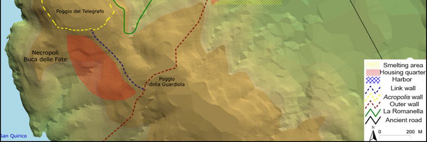
Land 2018, 7, 94                                                                                                        8 of 16
  Land 2018, 7, x FOR PEER REVIEW                                                                                     8 of 16
    Land 2018, 7, x FOR PEER REVIEW                                                                                 8 of 16

         Figure  6. GIS
             6.6.GIS    general map  of Populonia’ssacred
                                                    sacred areas and
                                                                 and hilltop
                                                                     hilltopfortresses
                                                                              fortressesdistribution during the the
     Figure
       Figure     GISgeneral
                       generalmap
                               mapofofPopulonia’s
                                       Populonia’s sacred areas
                                                           areas and hilltop fortresses   distribution
                                                                                         distribution  during
                                                                                                      during the
     5th 5th century
         century   BC.BC.
       5th century BC.

          Populonia implemented the remarkable hilltop fortress system during the late 4th and early 3rd
      Populonia
        Populoniaimplemented
                   implementedthetheremarkable
                                     remarkable hilltop fortress
                                                            fortress system
                                                                     systemduring
                                                                              duringthe
                                                                                      thelate
                                                                                           late4th
                                                                                                4thand
                                                                                                     and   early
                                                                                                         early   3rd
                                                                                                               3rd
    centuries BC, when the pronounced Roman interest in Northern Etruria’s territories, particularly in
centuries  BC,  when  the pronounced
  centuries BC, when the pronounced RomanRoman    interest   in Northern Etruria’s territories, particularly in in
                                                                Northern   Etruria’s territories,   particularly
    the period between 311–283/282 BC, provided the foundation for the development of fortified hilltop
the period
  the periodbetween
              between311–283/282
                       311–283/282 BC, provided
                                         provided thethe foundation
                                                          foundationforforthe
                                                                           thedevelopment
                                                                               developmentofof     fortified
                                                                                                 fortified   hilltop
                                                                                                           hilltop
    settlements in Populonia’s territory [26,52,53] (Figure 7).
  settlementsininPopulonia’s
settlements       Populonia’sterritory
                              territory[26,52,53]
                                        [26,52,53] (Figure
                                                    (Figure 7).

          Figure 7. GIS general map of Populonia’s hilltop fortresses distribution during the Hellenistic period.

        Figure
     Figure    7. GIS
            7. GIS    general
                   general    mapofofPopulonia’s
                            map       Populonia’shilltop
                                                 hilltop fortresses
                                                         fortresses distribution
                                                                    distributionduring
                                                                                 duringthe Hellenistic
                                                                                         the           period.
                                                                                             Hellenistic period.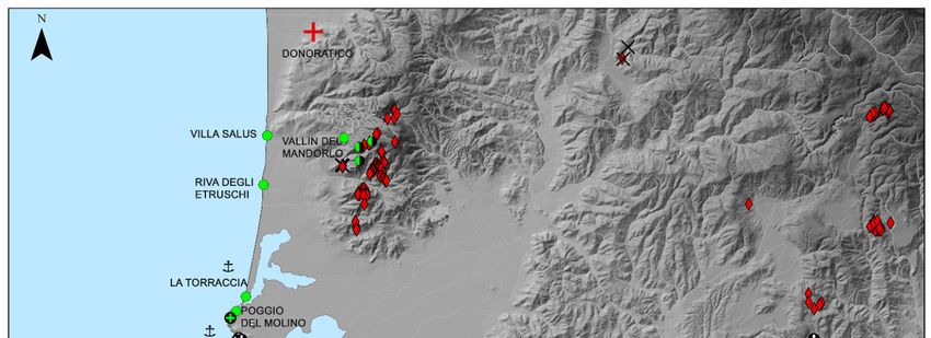
Land 2018, 7, 94 9 of 16
USV The chronological
Symbol Macro(s) sequence of events mentioned by Livy corresponds to diagnostic pottery and
Description
material finds discovered during archaeological excavations undertaken in a number of Populonia’s
03C8 ψ \textpsi GREEK SMALL LETTER PSI
hilltop fortresses. Considering the lack of a specific denomination in classical terminology, the term
03C9 ω \textomega GREEK SMALL LETTER OMEGA
03CA
“hilltop
ϊ fortress” allows us to contextualize the Island of Elba’s
\"{\textiota}
archaeological structures within an
GREEK SMALL LETTER IOTA WITH DIALYTIKA
03CB architectural
ϋ and structural
\"{\textupsilon} category. An examination of texts by classical authors provides some
GREEK SMALL LETTER UPSILON WITH DIALYTIKA
03CC termsό we might adopt to describe the archaeological evidence
\'{\textomicron} found
GREEK SMALL LETTERon the WITH
OMICRON Island
TONOS of Elba, such as
03CD ϕρoύριoν and castellum, since both denote “a fortress, a secondary
\textupsilonacute camp
GREEK SMALL LETTER UPSILONinWITH
defense
TONOS of a principal
\'{\textupsilon}
one or a strategic site, even a warehouse.” This type of site arose in response either to an imminent
03CE ώ \'{\textomega} GREEK SMALL LETTER OMEGA WITH TONOS
military threat or to various phases of imperial expansion and the position was often abandoned
03DA Ϛ \textStigmagreek GREEK LETTER STIGMA
03DB afterϛ such \textstigmagreek
threats had passed [26,52,53]. Before analyzingGREEK theSMALL
characteristics
LETTER STIGMA
of these settlements,
03DC we must
Ϝ examine the two factors that affect the topic of Populonia
\textDigammagreek GREEK LETTERcastella:
DIGAMMA (1) the majority of hilltop
03DD ϝ
fortresses are known only through archaeological surveys; GREEK
\textdigammagreek and SMALL
(2) the medieval
LETTER DIGAMMA castles’ overlapping
03DE Ϟ
of Etruscan \textKoppagreek
bastions [23,47]. On this basis, we can offer some GREEKhypotheses
LETTER KOPPA concerning the settlement
03DF ϟ
structures \textkoppagreek
and their role within the defensive system. In light of the archaeological data, it is possible
GREEK SMALL LETTER KOPPA
03E0 Ϡ \textSampigreek
to note a number of main features shared by these fortified GREEK LETTER SAMPI
settlements. First, they are located on
03E1 ϡ \textsampigreek GREEK SMALL LETTER SAMPI
a cleared hilltop in a strategic position, providing control over travel routes; mineral, agricultural,
03F6 ϶ \textbackepsilon GREEK REVERSED LUNATE EPSILON SYMBOL
and maritime resources; and crossroads. They were also surrounded by stonewalls for additional
0400 Ѐ \`{\CYRE} CYRILLIC CAPITAL LETTER IE WITH GRAVE
0401 defense.
Ё These
\CYRYO settlements were rectangular in plan, presumably to rectify the peak outlines and to
CYRILLIC CAPITAL LETTER IO
bestow a quadrangular
\"{\CYRE} plan. Their construction technique, for the most part, involved the placement
0402 Ђ
of rough-cut \CYRDJE
stones arranged in irregular rows; the walls were CYRILLICalso endowed
CAPITAL LETTER DJE with a brick base and
0403 Ѓ \'{\CYRG} CYRILLIC CAPITAL LETTER GJE
a clay court elevation. Inside the defensive walls, the buildings, about one hectare in area or less,
0404 Є \CYRIE CYRILLIC CAPITAL LETTER UKRAINIAN IE
were well structured. All of the fortresses were furnished with tanks for water conservation and areas
0405 Ѕ \CYRDZE CYRILLIC CAPITAL LETTER DZE
for storing other supplies; the houses were made with clay elevations and covered by a tiled roof
0406 І \CYRII CYRILLIC CAPITAL LETTER BYELORUSSIAN-UKRAINIAN I
0407 supported
Ї on a timber frame [52,53].
\CYRYI CYRILLIC CAPITAL LETTER YI
Set apart from each other at regular intervals of 9–10 km, the fortresses on the peninsula created
\"{\CYRII}
0408 Ј of defensive
a sort \CYRJE ring placed some distance inland fromCYRILLIC the coastline. In this way, the fortresses,
CAPITAL LETTER JE
0409 Љ \CYRLJE CYRILLIC CAPITAL LETTER LJE
either individually or in sets of two, could control a specific area or resource. As we can see through the
040A Њ \CYRNJE CYRILLIC CAPITAL LETTER NJE
ArcGIS viewshed analysis, their sphere of influence included direct control over the Colline Metallifere
040B Ћ \CYRTSHE CYRILLIC CAPITAL LETTER TSHE
mineral deposits [52,53]. The pottery record of the majority of the castella shows strong analogies to
040C Ќ \'{\CYRK} CYRILLIC CAPITAL LETTER KJE
040D
Populonia
Ѝ ceramics. On the basis of archaeological evidence,
\`{\CYRI}
the local products generally seemed
CYRILLIC CAPITAL LETTER I WITH GRAVE
040E to prevail
Ў over imported
\CYRUSHRT goods. On this subject, we must mention a small group of tombs related
CYRILLIC CAPITAL LETTER SHORT U
\U{\CYRU}
to the Monte Pitti fortress. Here the grave artifacts are quite significant and include imported fine
040F Џ and\CYRDZHE
pottery jewelry [54]. It is evident that Populonia created CYRILLIC CAPITAL LETTER DZHE
a hierarchical fortified system. On the
0410 А \CYRA
mainland, the sites that can be considered at the top of the CYRILLIC CAPITAL LETTER A
hierarchy, especially in terms of strategic
0411 Б \CYRB CYRILLIC CAPITAL LETTER BE
importance, include Donoratico, Monte Pitti, Poggio Castiglione, and Scarlino. On the Island of
0412 В \CYRV CYRILLIC CAPITAL LETTER VE
0413 Elba,Г on the contrary, the defensive network was characterized
\CYRG by two hilltop fortresses (Monte
CYRILLIC CAPITAL LETTER GHE
0414 Castello
Д and Castiglione San Martino) to which small-fortified
\CYRD settlements
CYRILLIC were
CAPITAL LETTER DE linked. Finally, ArcGIS
0415 Е
viewshed analysis
\CYRE indicates that all of the fortresses
USV Symbol Macro(s) were in direct
CYRILLIC CAPITAL visual
LETTER IE contact with each other.
Description
0416 Ж
In addition, the results of the latter study serve both to question
\CYRZH and LETTER
CYRILLIC CAPITAL increase
ZHE our knowledge about
0417 З \CYRZ concerning the supposed 03C8 ψ \textpsiCYRILLIC CAPITAL LETTER ZE GREEK SMALL LETTER PSI
the controversy reconstructions of ancient boundaries between Populonia,
0418 И \CYRI 03C9 ω \textomega
CYRILLIC CAPITAL LETTER I
GREEK SMALL LETTER OMEGA
Vetulonia, and Roselle. In fact, the viewshed
03CA
analyses
ϊ show that
\"{\textiota}
the castella of Poggio Castiglione andGREEK SMALL LETTER IOTA WITH
0419 Й \CYRISHRT CYRILLIC CAPITAL LETTER SHORT I
Scarlino were visually connected to03CB
\U{\CYRI}
Populonia ϋ and \"{\textupsilon}
its territory. On the other hand, the fortresses ofGREEK SMALL LETTER UPSILON W
041A Castel
К di Pietra
\CYRK and Montemassi have a reciprocal
03CC ό visual connection
\'{\textomicron}
CYRILLIC CAPITALwith
LETTER Poggio
KA di Moscona, whichGREEK SMALL LETTER OMICRON
041B Л
has recently been numbered among03CD
\CYRL the ϕρoύρια in\textupsilonacute
the territory of Roselle.
CYRILLIC CAPITAL LETTER EL These hilltop fortresses GREEK SMALL LETTER UPSILON W
041C М \CYRM \'{\textupsilon}
were only abandoned between the mid-second and first centuries BC after imminent military threats
CYRILLIC CAPITAL LETTER EM
041D Н region \CYRN
03CE ώ \'{\textomega} GREEK SMALL LETTER OMEGA W
in the had diminished and the area as a whole was slowly Romanized [26,52,53].
CYRILLIC CAPITAL LETTER EN
041E ОIt is reasonable
\CYRO
03DA Ϛ \textStigmagreek
CYRILLIC CAPITAL LETTER O
GREEK LETTER STIGMA
to consider Populonia’s
03DB ϛ strategically placed hilltop fortresses as a reaction toGREEK SMALL LETTER STIGMA
\textstigmagreek
041F П \CYRP CYRILLIC CAPITAL LETTER PE
danger and threat and, simultaneously, 03DCas the Ϝoutcome of surplus wealth, which would certainly haveGREEK LETTER DIGAMMA
\textDigammagreek
0420 Р \CYRR CYRILLIC CAPITAL LETTER ER
0421
beenСrequired \CYRS
to realize the fortified03DD
settlementϝ systems. Thus, we can imagine that the Classical andGREEK SMALL LETTER DIGAMMA
\textdigammagreek
CYRILLIC CAPITAL LETTER ES
0422 the Hellenistic
Т \CYRT landscape both on 03DE
the mainland Ϟ of \textKoppagreek
Populonia and on the Island of Elba had assumedGREEK LETTER KOPPA
CYRILLIC CAPITAL LETTER TE
03DF ϟ \textkoppagreek GREEK SMALL LETTER KOPPA
03E0 Ϡ \textSampigreek GREEK LETTER SAMPI
03E1 ϡ 19 \textsampigreek GREEK SMALL LETTER SAMPI
03F6 ϶ \textbackepsilon GREEK REVERSED LUNATE EPSILO
0400 Ѐ \`{\CYRE} CYRILLIC CAPITAL LETTER IE WIT
0401 Ё \CYRYO CYRILLIC CAPITAL LETTER IO
\"{\CYRE}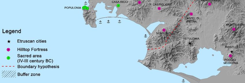
Land 2018, 7, 94                                                                                                          10 of 16

   Land 2018, 7, x FOR PEER REVIEW                                                                                     10 of 16
particular features as a “landscape of prosperity and of worry” [23,47].The central place is again
concentrated   on concentrated
   place is again  the Populonia  onacropolis which,
                                     the Populonia    endowed
                                                    acropolis      withendowed
                                                                which,   an upperwithwall,anbecame  the main
                                                                                              upper wall,       focus
                                                                                                           became
of the
   the fortified
       main focussettlements   and the
                    of the fortified    stronghold
                                     settlements andofthe
                                                        thestronghold
                                                             territorial of
                                                                         defense.  Its strategic
                                                                            the territorial       position
                                                                                             defense.        allowed
                                                                                                      Its strategic
a reciprocal
   position allowed a reciprocal visual connection among most of the hilltop fortresses inand
              visual  connection   among   most  of the  hilltop  fortresses  in the Campigliese    district    theon
theCampigliese
    Island of Elba   [55] (Figure  8).
                 district and on the Island of Elba [55] (Figure 8).

                                   Figure 8. GIS viewshed analysis map from Populonia.
                                  Figure 8. GIS viewshed analysis map from Populonia.

   4. A “Liminal Landscape” in the Territory of Populonia
4. A “Liminal Landscape” in the Territory of Populonia
         The term “liminal” comes from the Latin word limen, which means border. The Concise Oxford
   Englishterm
      The         “liminal”
             Dictionary       comes
                          defines       from the
                                     liminal       Latin
                                               as an       word limen,
                                                      adjective     relatingwhich    means border.
                                                                              to a transitional           The Concise
                                                                                                      or initial stage orOxford
                                                                                                                            at a
English    Dictionary    defines    liminal    as  an  adjective     relating   to a    transitional
   boundary or threshold [56]. Thus, there are different meanings and connotations linked to this        or  initial  stage  or at
                                                                                                                         word.
a boundary      or threshold    [56].    Thus,   there  are   different    meanings       and    connotations
   Arnold van Gennep was the first scholar who used the term “liminal” in his analyses of rituals.                 linked  to  this
word.
   WithinArnold    van Gennep
             transitional   rites, hewasdistinguishes
                                            the first scholar
                                                            threewho      used the
                                                                     categories   of term       “liminal” in his
                                                                                        rites—preliminary,            analyses
                                                                                                                  liminal   and of
rituals.   Within transitional
   postliminal—connecting        eachrites,
                                         oneheto distinguishes
                                                  a different stage  three  categories
                                                                        in human             of the
                                                                                      life. In   rites—preliminary,
                                                                                                      second chapter ofliminal
                                                                                                                            The
andRites of Passage, he discusses territorial passage, analyzing the rituals used when entering the neutral of
      postliminal—connecting           each   one  to a  different    stage   in human        life. In  the  second    chapter
Thegrounds
     Rites ofbetween
               Passage,marked
                         he discusses       territorial
                                  territories   [57]. Vanpassage,
                                                            Gennep’s  analyzing
                                                                         ideas werethefurther
                                                                                           rituals  used whenbyentering
                                                                                                  investigated        the socialthe
   anthropologist
neutral               Victor Turner,
          grounds between      markedwho         concentrated
                                           territories  [57]. Van  onGennep’s
                                                                       the liminal
                                                                                 ideas phase
                                                                                           wereoffurther
                                                                                                     initiation  rituals, with
                                                                                                            investigated    by the
   particular  attention  to  related   social  and  symbolical     aspects  [58].
social anthropologist Victor Turner, who concentrated on the liminal phase of initiation rituals, with
         ‘’Liminal
particular          landscapes’’
             attention  to relatedare    geographical
                                      social              areas set
                                              and symbolical          in rougher
                                                                   aspects   [58]. topographic environments such as
   mountains,
      “Liminal forests,   heathlands,
                  landscapes”              wetlands, coastal
                                  are geographical       areas setareas
                                                                      in and   arctictopographic
                                                                          rougher       zones. [59]. environments
                                                                                                        To inhabit a liminal
                                                                                                                          such as
   landscape    has  frequently    implied     the  need   to   adopt   particular    ways,     structures
mountains, forests, heathlands, wetlands, coastal areas and arctic zones. [59]. To inhabit a liminal          and   routines  of
   living.  Basically these  different    results consist   of:  house  construction      using   raw
landscape has frequently implied the need to adopt particular ways, structures and routines of living.  perishable   materials,
   land reclamation work, flow regulation work and terracing [60] (p. 9). Liminal landscapes are often
Basically   these different results consist of: house construction using raw perishable materials, land
   associated with nature and the relative wilderness lying beyond cultivated spheres. Such
reclamation work, flow regulation work and terracing [60] (p. 9). Liminal landscapes are often
   associations have contributed to the downgrading of liminal landscapes’ historical, cultural and
associated with nature and the relative wilderness lying beyond cultivated spheres. Such associations
   social importance in society. Moreover, these outlying areas are generally considered passive (as
have contributed to the downgrading of liminal landscapes’ historical, cultural and social importance
   compared to an active center) and are thus judged to be marginal also from a social perspective.
in society. Moreover, these outlying areas are generally considered passive (as compared to an
   From the local inhabitants’ viewpoint, the same landscapes, even when they are hardly marginal, are
Land 2018, 7, 94 11 of 16
active center) and are thus judged to be marginal also from a social perspective. From the local
inhabitants’ viewpoint, the same landscapes, even when they are hardly marginal, are central in terms
of subsistence
Land 2018, 7,strategies for the local people. The marginal landscapes of today were not 11
x FOR PEER REVIEW necessarily
of 16
the marginal landscapes of the earlier times [59]. Thus, the concept of “liminal” becomes an issue
central in terms of subsistence strategies for the local people. The marginal landscapes of today were
between relative points of view. Some archaeologists are currently working on the intensive exchange
not necessarily the marginal landscapes of the earlier times [59]. Thus, the concept of “liminal”
connections
becomes and tightbetween
an issue culturalrelative
material proximity
points existing
of view. Some between central
archaeologists or hegemonic
are currently working onareas the and
marginal
intensive exchange connections and tight cultural material proximity existing between central or not
or subordinate zones. In a new perspective, we can see new connectivity trajectories
only between
hegemonic different
areas and cultural geographic
marginal areas but
or subordinate also among
zones. In a new elements that traditional
perspective, we can seeviewpoints
new
connectivity
considered opposite, trajectories not only
i.e., fortified citiesbetween different vs.
and countryside cultural geographic
eschatia, Romanareas but vs.
century also among
saltus, citizens
elements vs.
and peasants thatpastores
traditional viewpoints
[60] considered
(p. 6). Thanks opposite,
to the i.e., fortified
influence cities and
of P. Horden andcountryside
N. Purcell’s vs. book,
eschatia, Roman
The Corrupting Sea [61], century
a new vs.understanding
saltus, citizens and peasants vs.
of marginal pastores is
categories [60]
one(p.of
6).the
Thanks
mosttoimportant
the
influence of P. Horden and N. Purcell’s book, The Corrupting Sea [61], a new understanding of
advances in Mediterranean landscape archaeology research in recent years.
marginal categories is one of the most important advances in Mediterranean landscape archaeology
With this premise, there is an example of “liminal landscape” that, for several reasons, can be
research in recent years.
distinguishedWithinthisa specific
premise,areatherelocated in the northeastern
is an example stretch ofthat,
of “liminal landscape” territory between
for several Populonia
reasons, can be and
Volterra.
distinguished in a specific area located in the northeastern stretch of territory between Populonia water
At first, it was demarcated by specific morphological features, such as hills, woods,
(especially in the form
and Volterra. of hot
At first, anddemarcated
it was cold sulphur springs),
by specific and geothermal
morphological phenomena
features, such as hills,[62] (Figure 9).
woods,
water (especially
The liminal aspect of this in the form
area of hot and
appears cold been
to have sulphur springs), and
understood by geothermal
the ancients phenomena
who, cognizant[62] of
(Figure
“natural 9). The
forces”, liminal aspect
introduced of this
specific area appears
sanctuaries andto have been
sacred areas;understood by the the
these included ancients who, and
Hellenistic
cognizant of “natural forces”, introduced specific sanctuaries and sacred areas; these included the
Roman complex devoted to the cult of Minerva and Silvano in the Sasso Pisano area [63] (Figure 10),
Hellenistic and Roman complex devoted to the cult of Minerva and Silvano in the Sasso Pisano area
and the Roman cult of Bellona in the Monteverdi Marittimo district, which in all likelihood was
[63] (Figure 10), and the Roman cult of Bellona in the Monteverdi Marittimo district, which in all
preceded by a Hellenistic
likelihood was preceded equivalent [23,46].equivalent
by a Hellenistic These cults wereThese
[23,46]. significantly
cults were linked to woods,
significantly linkedwater
to and
the wilderness,
woods, water andand were theprobably
wilderness,alsoand
tied
wereto ancient
probablypastoral
also tied activities.
to ancientThe archaeological
pastoral activities. Theevidence
for these practices isevidence
archaeological very difficult to detect
for these practicestoday. Although
is very difficult the lack oftoday.
to detect archaeological
Although the evidence
lack of urges
archaeological evidence urges us towards a cautious approach, we might
us towards a cautious approach, we might be able to re-evaluate the role of this peripheral district be able to re‐evaluate the and
role of this peripheral district and its close relationship with the
its close relationship with the central place. Starting approximately from the 6th century BC, Populoniacentral place. Starting
began approximately from the 6th century BC, Populonia began to extend its influence on the
to extend its influence on the Monterotondo area, located on the borders of its territory [64,65].
Monterotondo area, located on the borders of its territory [64,65]. This expansion might not be a
This expansion might not be a coincidence since, among the various reasons, we can recall Populonia’s
coincidence since, among the various reasons, we can recall Populonia’s need for wood resources to
need for wooditsresources
support to support its
intensive metallurgical intensive
activities metallurgical activities [66,67].
[66,67].
Figure 9. An example of the geothermal phenomena in the Sasso Pisano area.
Figure 9. An example of the geothermal phenomena in the Sasso Pisano area.Land 2018, 7, 94 12 of 16
Land 2018, 7, x FOR PEER REVIEW 12 of 16
Land 2018, 7, x FOR PEER REVIEW 12 of 16
Figure 10.
Figure 10. The
The Sacred
Sacred thermal
thermal complex
complex in
in the
the Sasso
Sasso Pisano
Pisano area,
area, known
known as the Il
as the Il Bagnone
Bagnone
Figure 10. Thearea.
archaeological Sacred thermal complex in the Sasso Pisano area, known as the Il Bagnone
archaeological area.
archaeological area.
The exploitation of this particular district and its natural resources also continued during the
The exploitation of this particular district and its natural resources also continued during the
Classical and Hellenistic periods [64,65]. As a result of increased Roman pressure, Populonia might
Classical and Hellenistic periods [64,65]. As a result of increased Roman pressure, Populonia might
have reinforced its control over this area by building the boundary hilltop fortress of Castiglion
have reinforced its control over this area byby building
building the
the boundary
boundary hilltop
hilltop fortress of Castiglion
Castiglion
Bernardi [26,52,53] (Figure 11).
Bernardi [26,52,53] (Figure
(Figure 11).
11).
Figure 11. GIS general map of Populonia’s sacred areas and hilltop fortresse distribution during the
Figure
Figure 11. GIS
Hellenistic
11. GIS general
period. map
The map
general of Populonia’s
Populonia’s
northeastern
of sacred
stretchsacred areasbetween
of territory
areas and hilltop
and hilltop fortresse
Populonia distribution
and
fortresse during the
Volterra. during
distribution the
Hellenistic period. The northeastern stretch of territory between Populonia and Volterra.
Hellenistic period. The northeastern stretch of territory between Populonia and Volterra.Land 2018, 7, 94 13 of 16
5. Conclusions
This article aims to outline my new data on the urbanization of Populonia starting from its
foundation, with particular reference to the results of archaeological surveys carried out by the
University of Siena since the 1980s. The landscape archaeology approach has allowed us to reconstruct
the Etruscan city’s organization of settlements as well as its management of resources. In addition, this
investigative tool has proven the most effective method to detect both places of economic or ideological
centrality and specific liminal landscapes in the territory of Populonia. Our research leads us to
suggest—in spite of several anomalies in the urban development process and unconventional choices
in the control of Populonia’s territory—that the Etruscan city’s acropolis seems to have played the role
of central place starting right from the establishment of the city. A hierarchical settlement system, based
on a network of sites and the foundation of new population centers, was promoted starting from the
end of the 9th—the beginning of the 8th century BC. Once the city ended its development process and,
especially, in the Hellenistic period, policies such as the hierarchical settlement system in the chora and
supply basin exploitation were mainly implemented through the foundation of hilltop fortresses both
on the mainland and on the Island of Elba. The central place was again concentrated on the Populonia
acropolis which, endowed with an upper wall, became the main focus of the fortified settlements
and the stronghold of the defence against Roman imperialism. Within some of the new acquisitions
coming from my PhD research we have to consider the feature of the hilltop fortresses system and
the detection of a “liminal landscape” in the northeastern stretch of the territory between Populonia
and Volterra. This particular part of the landscape had been a sacred district with a strong peripheral
character and possibly close connections to the central place thanks to the significant availability of
natural resources.
Funding: This research received no external funding.
Acknowledgments: I would like to thank Franco Cambi, my tutor, Maria Luisa Marchi, Andrea Zifferero,
Simon Stoddart, my co-tutors, and to Giuliano Volpe for having supported me during my PhD research project.
A special thank goes to the “Soprintendenza per i Beni Archeologici della Toscana” for the administrative and
technical supports. My PhD research has benefited greatly from discussion with Cynthia Mascione, Matteo Milletti,
Elisabetta Ponta and Luisa Dallai. I am also grateful to Daniele Manacorda, Gabriele Cifani and Maria Grazia
Granino for their suggestions and availability. Last but not least, my thanks go to Giorgos Papantoniou and
Athanasios Vionis who encourage me to write down this paper.
Conflicts of Interest: The author declares no conflict of interest.
References
1. Cifani, G. Storia di una Frontiera. Dinamiche Territoriali e Gruppi Etnici Nella Media Valle Tiberina dalla Prima età
del Ferro alla Conquista Romana; Istituto Poligrafico e Zecca dello Stato: Roma, Italy, 2003; p. 23. (In Italian)
2. Turner, F.J. The Frontier in American History; H. Holt and Company: New York, NY, USA, 1945.
3. Lattimore, O. Studies in Frontier History. Collected Papers; Oxford University Press: London, UK, 1962.
4. Wallerstein, I. The Modern World-System; Academic Press: New York, NY, USA, 1974; Volume 1.
5. Sherratt, A. What Would a Bronze-Age World System Look Like? Relations between Temperate Europe and
the Mediterranean in Later Prehistory. J. Eur. Archaeol. 1993, 1, 1–57. [CrossRef]
6. Sherratt, A. ‘Who are you Calling Peripheral?’ Dependence and Independence in European Prehistory.
In Trade and Exchange in Prehistoric Europe; Scarre, C., Healy, F., Eds.; Oxbow Monograph 33; Oxbow Books:
Oxford, UK, 1993; pp. 245–255.
7. Sherratt, A. Core, Periphery and Margin: Perspectives on the Bronze Age. In Development and Decline in
the Mediterranean Bronze Age; Mathers, C., Stoddart, S., Eds.; J.R. Collis Publications: Sheffield, UK, 1994;
pp. 335–345.
8. Donnan, H.; Wilson, T. Borders: Frontiers of Identity, Nation and State; Berg Publishers: Oxford, UK, 1999.
9. Green, S.F. Notes from the Balkans. Locating Marginality and Ambiguity on the Greek-Albanian Border; Princeton
University Press: Princeton, NJ, USA, 2005.You can also read