Wellington Water Seaview Waste Water Treatment Plant Intermittent Discharge Recreation effects assessment
←
→
Page content transcription
If your browser does not render page correctly, please read the page content below
October 2017 Draft ver 2
                                                                                       1

                                    Rob Greenaway & Associates

                                    Wellington Water Seaview
                                    Waste Water Treatment Plant
                                    Intermittent Discharge
                                    Recreation effects assessment

Wellington Water Seaview WWTP Intermittent Discharge | Recreation effects assessment
Rob Greenaway & Associates
2

Wellington Water
Seaview Waste Water Treatment
Plan Intermittent Discharge
Recreation effects assessment

Prepared for Stantec Ltd
by Rob Greenaway & Associates
www.greenaway.co.nz

October 2017

Version status: Draft ver 2: 10 October 2017

Wellington Water Seaview WWTP Intermittent Discharge | Recreation effects assessment
Rob Greenaway & Associates
3
Contents
1 Summary ................................................................................................................................... 4
1.1 Introduction .................................................................................................................... 4
1.2 Findings ......................................................................................................................... 5
1.2.1 Recreation activities ................................................................................................ 5
1.2.2 Proposal effects ...................................................................................................... 7
1.3 Method ........................................................................................................................... 8
1.4 Author experience and expertise.................................................................................... 9
2 Literature review - recreation................................................................................................. 10
2.1 National marine recreation participation ....................................................................... 10
2.2 Regional recreation activity distribution ........................................................................ 12
2.2.1 Shellfish gathering and swimming ......................................................................... 14
2.2.2 Fishing .................................................................................................................. 18
2.2.3 Boating and sailing ................................................................................................ 21
2.3 Terrestrial recreation .................................................................................................... 24
3 Interview summaries by activity ............................................................................................ 26
3.1 Boating ......................................................................................................................... 26
3.1.1 Kayaks, rafts, SUP ................................................................................................ 26
3.1.2 Keelers and launches ............................................................................................ 26
3.1.3 Waka ..................................................................................................................... 27
3.1.4 Rowing .................................................................................................................. 27
3.1.5 Model boating........................................................................................................ 27
3.1.6 Kite and wind surfing ............................................................................................. 27
3.2 Harvesting .................................................................................................................... 28
3.2.1 Fish ....................................................................................................................... 28
3.2.2 Shellfish ................................................................................................................ 28
3.3 Swimming and wharf jumping ...................................................................................... 29
3.4 Terrestrial ..................................................................................................................... 29
4 References .............................................................................................................................. 30
List of Tables
Table 1: Participation locations in natural settings, Wellington (Sport NZ 2015a) ................................... 12
Table 2 :Activities recorded from Estuary Bridge downstream (Greenaway, 2015) ................................ 12
List of Figures
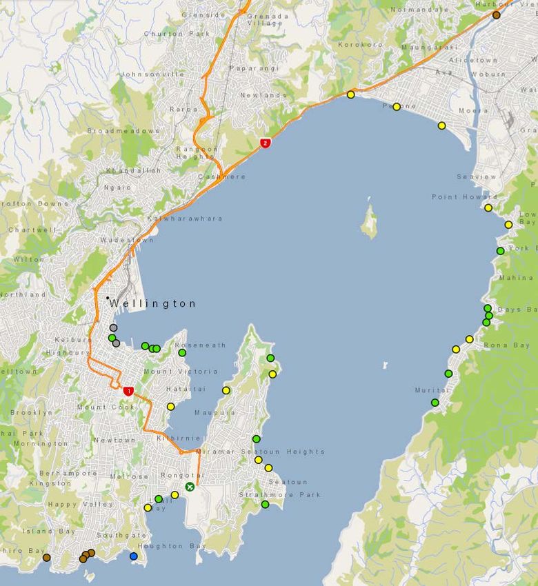
Figure 1: Main activity areas - summary ................................................................................................... 5
Figure 2: Sport and recreation activities with the highest participation levels (SPARC 2009b) ............... 10
Figure 3: Shellfish and line fishing sites from Allen et al 2009 ................................................................ 14
Figure 4: GWRC Regional Coastal Plan Coastal Water Classes for Wellington Harbour ....................... 15
Figure 5: GWRC monitored marine bathing sites in and around Wellington Harbour ............................. 16
Figure 6: SLNZ recommended swimming beaches ................................................................................ 17
Figure 7: Surfcasting guide recommendation, Draper & Airey (2012) ..................................................... 18
Figure 8: Boat fishing guide recommendation, Airey (2014) ................................................................... 20
Figure 9: Boat club, club and DOC mooring and ramp locations, Wellington Harbour ............................ 22
Figure 10: Windsurf launch sites ............................................................................................................. 22
Figure 11: Sail racing marks Wellington Harbour .................................................................................... 23
Figure 12: Public access around the Hutt River mouth – Source: WAMS............................................... 24
Figure 13: Hutt City online GIS recreation areas..................................................................................... 25
Wellington Water Seaview WWTP Intermittent Discharge | Recreation effects assessment
Rob Greenaway & Associates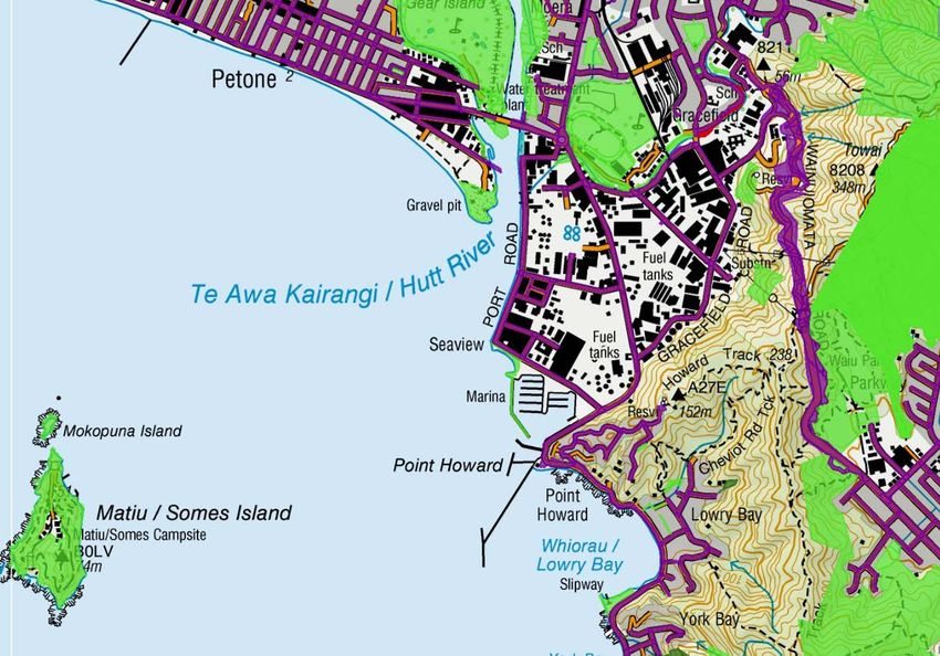
4
1 Summary
This report:
Identifies the recreation activities undertaken in the area potentially affected by the
proposed Seaview Waste Water Treatment Plan (WWTP) Intermittent Discharge; and
Reviews the potential effects on recreation of the location of the discharge point south
of the Waiwhetū Stream confluence in the mouth of the Hutt River.
The bulk of this report describes the relevant recreation opportunities. The effects of the
discharge on recreationally-taken fish and shellfish and on water quality are summarised in
the relevant assessment reports described in the Seaview WWTP Intermittent Discharges
Resource Consent and AEE. These data are not repeated in detail in this recreation report,
but relevant factors are reviewed in section 1.2.2.
This assessment finds that the proposal has a minor adverse effect on recreation amenity.
Adverse effects are limited by:
The low frequency and short duration of unplanned discharges,
The management of controlled maintenance discharges to occur in winter,
Timing of planned discharges to occur on outgoing tides,
The discharge plume to be limited to the true left of the flow of the Hutt River,
avoiding effects on contact recreation in a proximate area on the true right around the
Sea Scouts facility,
The coincidence of rainfall-related overflow discharges with high (if not higher) levels
of background contamination,
Established expectations that shellfish gathering in an urban area with many
stormwater discharge points is inadvisable.
Health warnings will be required during planned and unplanned discharges along Port Road
specific to whitebaiting (during the season) and contact recreation. As stated, during wet
weather discharges, the potential for adverse effects are masked by high background levels
of contamination in the Hutt River and Waiwhetū Stream, and standard rain-event warnings
will remain necessary.
1.1 Introduction
Wellington Water is reconsenting the existing outfall in Waiwhetū Stream which is used to
discharge treated wastewater when heavy rains exceed the capacity of the system, or if the
discharge pipe to the coast at Pencarrow needs maintenance. Rain events mean it is used an
average of four or five times a year, and maintenance requirements mean it might operate for
a week or so every few years. A preferred alternative location for the discharge has been
identified to the south of the confluence of the Waiwhetū Stream with the Hutt River mouth
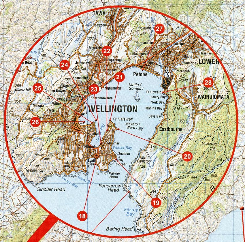
(Figure 1).
This assessment considers the discharge as a new activity and reviews effects without the
existing discharge in place.
An earlier version of this study was used in assessing alternative locations for the new outfall.
The assessment area is defined by the marine and river areas where treated wastewater has
the potential to disperse to, defined by the 10m depth contour between the Petone Wharf and
Wellington Water Seaview WWTP Intermittent Discharge | Recreation effects assessment
Rob Greenaway & Associates
5

the southern end of Lowry Bay, and up to the Estuary Bridge on the Hutt River, and the
Wainui Road Bridge on the Waiwhetū Stream (the dotted line in Figure 1).

1.2     Findings

1.2.1    Recreation activities
Figure 1 shows the main recreation activities in the study area.

While fishing and boating were identified as occurring throughout the study area, the main
locations for fishing are the Petone Wharf (although currently closed due to earthquake
damage), the Estuary Bridge and the western area of the Hutt River mouth (particularly for
netting), Point Howard and Lowry Bay.

Small boats frequent the Hutt River mouth area, Lowry Bay and the Petone Beach area, and
include waka ama (competitive outrigger canoes), waka taua (large ceremonial or war
canoes), rowers, sailing dinghies, kayakers, rafters (mostly Sea Scouts), sea kayakers and
SUP (stand-up paddle boarding). Larger vessels are based out of Seaview Marina and the
Lowry Bay ramp, and pass through the area, and also occasionally fish. Sladden Park,
Hikoikoi Reserve and the Sea Scouts site are also launching areas for small craft. Waka taua

                                     Figure 1: Main activity areas - summary

  Key

              Proposed outfall discharge site
               Study area boundary

               Whitebaiting

               Walking, cycling on paths

               Beach activities and swimming

               Shellfish gathering

               Kite and wind surfing

               Fishing

               Keelers, launches / cruisers,
               trailer craft
               Small boats – rowing, sailing,
               SUP, kayak, waka, dinghies

Wellington Water Seaview WWTP Intermittent Discharge | Recreation effects assessment
Rob Greenaway & Associates
6

have used Waiwhetū Stream to the urupa, and sea kayakers might rarely ‘poke their nose’
into the waterway.

Shellfish gathering is reported to occur at the Petone Beach (pipes and cockles) and Point
Howard and Lowry Bay (mussels). Point Howard is a recreational shellfish gathering water
quality monitoring site. A 2013 study of the microbiological effects of a treated wastewater
discharge to Waiwhetū Stream (MWH, 2013) recommended that shellfish should not be
collected for human consumption at locations between Petone Beach west and Lowry Bay
less than four weeks after a discharge of treated wastewater to Waiwhetū Stream, or less
than four weeks after a significant high flow event in the Hutt River or Waiwhetū Stream,
which may result in the discharge of contaminated stormwater or an overflow of wastewater
into these water bodies. It was noted that this restriction would likely rule out much of the
year, but would be consistent with the general advice previously provided by Regional Public
Health, and by the New Zealand Food Safety Authority, to not collect shellfish near urban
areas because of the on-going impact of stormwater and sewage related contamination.
Whitebaiting occurs during the season on both banks of the Hutt River near the mouth.
Potential whitebait habitat has been identified in the Waiwhetū Stream, but there was no
fishing activity identified in this study.
Swimming occurs at all beach areas – Petone, Lowry, Sorrento – and around the Sea Scouts
building. The Sea Scouts and Cadets activities result in many instances of water contact
recreation in their area. Beaches are used for casual recreation, such as picnics, walking and
dog walking. Recreational water quality is monitored at two sites on Petone Beach, at Point
Howard and in Lowry Bay.

Wind surfers and kite surfers use the offshore area when conditions permit, with kite surfers
launching from the Petone foreshore area.

Almost all the coastal margin is publicly accessible from adjacent land, and is bordered by
walking and cycle opportunities, both on and off-road.

Waiwhetū Stream was reported to have little in-water recreation, with some fishing near its
mouth, rare waka taua activity, and an occasional small boat. Walking and cycling on the
nearby paths were the main reported activity, with volunteer planting on its banks.

The Hutt River to its mouth is identified as a primary water contact site for recreation and as a
trout fishery in the Proposed Natural Resources Plan for the Wellington Region, and a first
order priority area for improvement for contact recreation and Māori customary use; and the
Waiwhetū Stream is identified as a second order priority area for improvement.

Almost all activities occur on all tides and at all times of the day. Fishing on incoming tides is
preferred for some activities, especially whitebaiting and shore fishing, and can occur at night.
Shellfishing (although not advised) is preferred at low tides, and swimming at high. Almost all
activities include some form of contact with the water, with consumptive activities associated,
as expected, with fishing and shellfishing. Summer is the busiest season. Weather is the key
limiting factor for participation. Section 3 includes summaries of these factors by activity.

The Hutt River mouth, Petone Beach and Lowry Bay are most likely the busiest locations in
the study area for recreation, and the Hutt River mouth has the highest variety of activities
undertaken. The River mouth area is likely to be one of the more busy recreation settings in
Wellington Harbour after the Lambton Harbour area and Oriental Bay, although the study
area is very unlikely to compete as a swimming site with the bays south of Lowry Bay and
east and south of Oriental Bay.

Wellington Water Seaview WWTP Intermittent Discharge | Recreation effects assessment
Rob Greenaway & Associates
7

1.2.2    Proposal effects
The proposal is to locate and operate an intermittent waste water discharge south of the
Waiwhetū Stream confluence extending 8m into the Hutt River mouth beyond the intertidal
zone. Storage will mean discharges can be managed to almost always occur on outgoing
tides, significantly reducing the potential for discharge to flow up the Hutt River and Waiwhetū
Stream on incoming tides. The corollary requirement is for an increased rate of flow during
discharge periods. On rare occasions, when the available storage is full due to peak wet
weather flows, the tidal discharge option might not be available. At such times, elevated flows
in the Hutt River and Waiwhetū Stream typically overcome the tidal inflow resulting in surface
waters moving in a downstream direction throughout the tidal cycle, preventing upstream
movement of the discharge.
Discharge periods, based on historic events, would be for a rare maximum of six weeks in the
period 5 May to 5 July, and/or a discharge of up to two weeks at any other time. A discharge
of more than six weeks has occurred only once, in 2009, when a malfunction at the main
pump station resulted in excessive pressure in the pipeline and damage to multiple pipeline
joints. Hutt City Council records show that discharge durations are typically far less, averaging
one event per year with a duration of six or seven days.

A dye and dispersion study shows that the discharge remains on the eastern side of the Hutt
River (true left) and does not cross the midline of the river channel. Activities in the plume
area potentially affected include whitebaiting on the true left of the Hutt River mouth, and
beach activities west of the Seaview marina. Fish other than whitebait taken recreationally in
the mouth area may also pass through the plume, and some line-fishing occurs at the
Waiwhetū stream mouth. Walkers and cyclists pass nearby on Port Road.
Water quality effects have been assessed in the XXX study under two scenarios:
programmed maintenance discharges and wet weather overflow discharges. The scale of
effect of these discharges on human health and biota are summarised in the Assessment of
Environmental Effects report.

During wet weather overflows, and periods when rain events overcome storage during
maintenance discharges, the levels of background contamination in the Hutt River and
Waiwhetū Stream mask that of the discharge and result in no additional requirements to avoid
contact recreation or the consumption of shellfish in the affected area (Petone Beach west to
Lowry Bay south). Wet weather and high flow periods have low recreation amenity generally.
Standard and existing recreational warnings about avoiding water contact and the taking of
shellfish during and after high river flow periods will remain necessary with the proposed
outfall in place, and during significant rain events there is unlikely to be any additional
restriction on recreation in the study area as a result of the proposal.

Planned maintenance discharges are programmed for winter when recreation use is low, and
outside the whitebait season. There are unlikely to be any changes to winter recreation
patterns as a result.

Unplanned maintenance discharges can occur at any time, but are likely for shorter periods of
two weeks. The worse-case scenario for recreation would be an unplanned discharge
occurring during the whitebait season, although whitebaiting occurs on incoming tides, with
planned discharges timed for ebb tides. The aquatic ecology assessment indicates that the
discharge will not have any effect on fish migration. High southerly wind events could drive
surface water back up the Hutt River mouth, but the level of dilution would be extremely high
upstream of the discharge and on the true right (David Cameron, Stantec, pers comm).

Wellington Water Seaview WWTP Intermittent Discharge | Recreation effects assessment
Rob Greenaway & Associates
8
There is unlikely to be an increased risk of illness resulting from contact recreation during
maintenance discharges; a result of the high level of treatment at the Seaview WWTP.
However, treatment occasionally – albeit rarely – does not fully remove all pathogens and so
it cannot be guaranteed that there will be no increase in risk (David Cameron, Stantec, pers
comm). The Assessment of Environmental Effects report does not characterise the change in
risk due to its small scale, but, as a precaution, health warning signs will be required to advise
and exclude whitebaiters on the true left of the Hutt River mouth, and beach users west of
Seaview marina, during discharge periods, and for both winter and summer for beach use to
include general coastal activities such as swimming a dog.
The frequency of these events is such that the net effect on recreation values will be minor.
The proposal presents the potential to create a recreation asset on the outfall structure. This
could include a fishing platform, or just a small seating area. Such options offer a benefit from
the proposal. The outfall will most likely create a focal point for whitebaiting where the fish are
forced around the structure and be more easily targeted upstream of it.
1.3 Method
This report is based on a literature review and interviews with 18 individuals with knowledge
of recreation patterns in the study area:
Greater Wellington Regional Council: Travis Moody, Hutt River Ranger
Hutt City Parks: Craig Cottrill
Friends of the Hutt River: Pat van Berkel
Harbour Master (GWRC): John Tattersall
Petone Community Board: Pam Hanna
Friends of Waiwhetū Stream: Merilyn Merrett
Lowry Bay Yacht Club: Colleen Christison
Seaview Marina: Suzanne Willis
St James Sea Scout Group: Kevin Biggins
Wellington Recreational Marine Fishers Association: Jim Mikoz
Wellington Yakity Yak Sea Club: Andy Blake
Wellington Ocean Sports: Philippa Durkin
Hikoikoi Waka Club: Petra Melville
Local whitebaiter: Ian Laing
Hutt River Trail - Rotary coordinator: Linton Adams
Local spear fisher: Derek Wilsher
Windsurfer, paddle board, kite surfer: Bruce Spedding
Te Runanganui o Taranaki Whanui kit e Upoko o te Ika a Maui Inc: Teri Puketapu
Site observations by Boffa Miskell in October confirmed whitebaiting activity to the south of
the proposed outfall.
Wellington Water Seaview WWTP Intermittent Discharge | Recreation effects assessment
Rob Greenaway & Associates
9

1.4     Author experience and expertise

The author of this report, Rob Greenaway, is an independent leisure and open space and
planner with 25 years’ experience. He has completed well-over 300 consultancy projects in
the recreation and tourism fields in New Zealand and the Pacific and has presented evidence
as an expert witness at more than 80 consent hearings. He is an Accredited Recreation
Professional, and a Fellow, with the New Zealand Recreation Association (and a member of
the NZRA’s accreditation board) and a member of the NZ Association for Impact Assessment.
In marine settings he has completed assessments for, for example, several marine farms in
Marlborough and the Kaipara, including the King Salmon proposal in 2012 for the
Marlborough District Council, several marina development proposals nationally (and is a
current member of the Nelson City Council Nelson Marina Advisory Committee), the consent
application to leave the remains of the wreck of the Rena on Astrolabe Reef, a review of
snapper quota proposals for the NZ Sport Fishing Council, recreation planning for the
Lyttelton Port Recovery Plan, a survey of recreational use of regional marine facilities for the
Christchurch City Council, and many other coastal recreation surveys and several marine
discharge reviews. He is currently working on three harbour deepening projects (Wellington,
Whangarei and Lyttelton), and the runway extension proposal for Wellington International
Airport.

Rob owns a 10 metre yacht based in Nelson and has extensive coastal and blue water sailing
experience spanning 50 years. He lived and worked in Wellington in the 1990s (and helped
establish and operate the original Big Coast mountain bike events around the Rimutaka
Range and along the Pencarrow Coast), and has completed various consultancy projects in
the region, including assisting with the 2015 masterplan for Mount Victoria for Wellington City,
and the 2016 survey of recreational use of the Hutt River Corridor for the Greater Wellington
Regional Council.

Wellington Water Seaview WWTP Intermittent Discharge | Recreation effects assessment
Rob Greenaway & Associates
10

2           Literature review - recreation

2.1       National marine recreation participation

Various estimates are available for the number of marine fishers in New Zealand. Kearney
(2002) reviews various studies which have given a wide range for the level of participation.
These include estimates based on surveys carried out between 1996 and 2000 ranging from
9.7% to 39% of the population (Reilly 2002 in Kearney 2002).
At the national level, reliable relative data (if not absolute) 1 are provided by the Active NZ
Surveys carried out by Sport New Zealand (previously SPARC – Sport and Recreation NZ)
(SPARC 2009a, 2015a). The data from the most recent studies (2007/08 and 2013/14) are
based on a stratified (by time and location) national respondent set of just over 4,400 and
6,400 adults aged over 16 respectively. The 2007/08 results showed that 19.3% 2 of all New
Zealand adults aged 16 years and over (633,768 people) had participated in fishing at least
once; 16.6% 3 had participated in marine fishing (539,515 adults aged over 16) and 5.7% 4 had
participated in freshwater fishing. This made marine fishing the 7th most popular form of
active recreation in NZ in 2007/08 (Figure 2), while freshwater fishing was ranked 21st equal
(with rugby union) (SPARC 2009b).

    Figure 2: Sport and recreation activities with the highest participation levels (SPARC 2009b)

The 2013/14 Active NZ results do not provide a breakdown by marine and freshwater activity.
Different methodologies also make comparison across the years problematic. However,
fishing participation was shown in this more recent survey as now the fifth most popular

1
  SPARC (2009a) notes: “The Active NZ Survey is a nationally representative survey of all New Zealand adults. The
findings in this profile are not directly comparable with other sources of information about fishing. This is because
methodological differences (e.g. the way data is collected, the definitions used) contribute to differences in findings
between different data sources.“
2
  (95% CI: 17.7–21.2)
3
  (95% CI: 15.0–18.3)
4
  (95% CI: 4.6–6.8)

Wellington Water Seaview WWTP Intermittent Discharge | Recreation effects assessment
Rob Greenaway & Associates
11 activity nationally at 19.5%, having over-taken jogging and running; and the third most popular activity for Maori. For men, fishing was the second-most popular form of recreation (29.2% participation), and for women, the ninth (10.5%). The level of participation in fishing (marine and freshwater) in the Wellington Region for 2007/08 was slightly less than the national average with 15.2% of the region’s population fishing (and 21.1% of men), making it the ninth-most popular active recreation or sport pursuit in the region (SPARC 2009c). The 2013/14 Active NZ survey showed that 15.8% of the regional population fished (Sport NZ 2015b). Variability between surveys needs to be treated cautiously due to the small regional sample size (488 respondents for the Wellington Region). At the national level, 3.8% of the population reported going diving in 2007/8, and in 2013/14 the figure was 3.4%; and 2.4% went sailing or yachting, and in 2013/14 the figure was 2.1%. Canoeing and kayaking also showed a growth in popularity between the surveys (from 6.3% to 8.2%) (SPARC 2009b & Sport NZ 2015a). This does not include the use of stand-up paddle boards, but does include sea kayaks and sit-upons. Such small data sets are not analysed at the regional level. The Active NZ surveys only consider physically active, non-motorised pursuits and so did not review motor boating participation. Kalafatelis & Magill (2013) completed a national survey of recreational boating activity for Maritime NZ with 1500 respondents. The results do not appear to have been filtered for marine activity only. This indicated, at the national level, that 24% of New Zealanders aged over 18 owned or used a vessel for recreation boating purposes (57% male and 43% female): 15% owned or used a canoe or kayak, 9% owned or used a power boat under 6m, 9% owned or used a dinghy, 5% owned or used a power boat over 6m, 3% owned or used a sail boat under 6m, 2% owned or used a sail boat over 6m, 2% owned or used a jet ski. During periods when boaties are ‘most active’, such as over summer, 24% of users of power boats under 6m went at least weekly, and another 25% went out once every couple of weeks. Similar levels of activity were evident for other vessels, but power boats under 6m were the most frequently used. The average number of years of boating experience was 12.9 years, with those owning or using kayaks and canoes the least experienced. Kalafatelis & Magill (2013) reported the ownership of types of vessel by region, but the levels of response by subgroup was not high and there is limited reliability in the data. Vance (2014) used the data gathered by Kalafatelis & Magill (2013) and older information to review trends in boat ownership. Eight Colmar Brunton surveys completed between 2002 and 2011 gave a range of 16% to 19% of households owning at least one boat in New Zealand; or 641,000 people and 727,000 vessels. Kalafatelis & Magill (2013) gave an estimate of 900,000 vessels. Vance (2014) estimates that between 30% and 50% of boat users go out at least every couple of weeks; and that levels of ownership have been reasonably consistent since at least 2006, but with possible increases in the ownership of trailer power boats and canoes Wellington Water Seaview WWTP Intermittent Discharge | Recreation effects assessment Rob Greenaway & Associates
12
and kayaks. However, the use of different survey methods means these trends are not
certain.
2.2 Regional recreation activity distribution
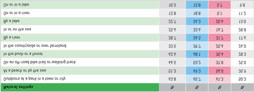
Sport NZ (2015a) reported on locations where respondents undertook their activities in
natural settings in the Wellington Region. Table 1 shows that beaches and other locations by
the sea where the second-most preferred setting for outdoor recreation (at 51.3% for all
Wellington Region adults), while being in or on the sea was relatively less popular at 25.4%,
but more popular that recreation on or in a river or lake.
Table 1: Participation locations in natural settings, Wellington (Sport NZ 2015a)
A survey of recreational use of the Hutt River Corridor was carried out by the Greater
Wellington Regional Council in 2015 (Greenaway, 2015). This showed the most frequently
recorded activities at, and downriver of, the Estuary Bridge were cycling, walking and dog
related activities. Swimming, fishing and small boating activities were also popular (Table 2).
The Corridor was divided into ten sections extending from the mouth to Harcourt Park. The
mouth area was the fifth-most popular section of the corridor for the number of activities
named (189 compared with 479 at for the Hutt City centre between Melling and Ewen Bridge),
and the sixth for number of respondents (74 compared with 214 for the Hutt City centre). The
majority of respondents in this section of the Corridor were from Hutt City. More respondents
considered the mouth area to be unsafe than safe, and there were personal safety concerns
experienced during the survey process around the Evans Park area.
Table 2 :Activities recorded from Estuary Bridge downstream
(Greenaway, 2015)
Activity Count
Walking 42
Cycling 32
Dog related 24
Swimming 12
Boating/sailing/waka/rafting/tubing/rowing 12
Fishing 12
Running 10
Wellington Water Seaview WWTP Intermittent Discharge | Recreation effects assessment
Rob Greenaway & Associates13
Table 2 :Activities recorded from Estuary Bridge downstream
(Greenaway, 2015)
Relaxing/socialising 7
Kayaking 7
Market 4
Golf/disc golf 4
Geocaching 3
Picnicking 3
Sport 2
Blackberries 2
Photography 2
Exercise 2
School/scout trip 1
Stone gathering/throwing 1
Access river/beach 1
Meditation/prayer/yoga 1
Firewood 1
Sand collecting 1
Campfire/camping 1
Family/playing 1
Kite flying 1
Total count 189
Biosecurity New Zealand released a review of coastal social values in 2009 (Allen et al 2009).
This indicated that, at the national level, there is only a very coarse understanding of the
distribution of marine recreation. The study considered beach recreation, surfing, diving,
boating and seafood gathering, but, in the main, only proxy information was used to identify
where these activities occur – such as the presence of a surf living saving club to identify
swimming locations or a yacht club for sailing. This resulted in broad descriptions of activity
patterns which are better described using more specific data sources (such as those
discussed elsewhere in this section). Figure 3 (over page) shows two examples of the scale
of data provided in Allen et al (2009).
Wellington Water Seaview WWTP Intermittent Discharge | Recreation effects assessment
Rob Greenaway & Associates14
Figure 3: Shellfish and line fishing sites from Allen et al 2009
Shellfish gathering locations
and local authority
monitoring sites
Recreational line fishing
locations and fishing clubs
2.2.1 Shellfish gathering and swimming
The Regional Coastal Plan for the Wellington Region (WRC, 2000) states that parts of the
waters of Wellington Harbour are to be managed for shellfish gathering purposes (10.2.1
p126), and that all of the harbour is to be managed for contact recreation purposes (10.2.2,
p127). These areas are defined in Planning Map 8D, much of which is shown in Figure 4,
over page. This shows shellfish gathering sites around, for example, Mātiu/Somes Island and
for much of the coast north of Pencarrow Head, and coastal waters east of Baring Head.
The Proposed Natural Resources Plan for the Wellington Region (GWRC July, 2015)
identifies Te Awa Kairangi / Hutt River as a: ‘regionally significant primary contact recreation
water body’ (Schedule H); a fresh water body for primary contact with a first order priority for
‘improvement of fresh and coastal water quality for contact recreation and Māori customary
use’ (Schedule H2); and as a trout fishery (Schedule 1). Schedule C4 identifies the Waiwhetū
Stream as a ‘site of significance to Taranaki Whānui ki te Upoko o te Ika a Maui’ for, amongst
other things, mahinga kai (a food source) and tauranga waka (a waka landing place).
Schedule H2 identifies the Waiwhetū Stream as a second order priority for ‘improvement of
fresh and coastal water quality for contact recreation and Māori customary use’.
Wellington Water Seaview WWTP Intermittent Discharge | Recreation effects assessment
Rob Greenaway & Associates15
Recreational shellfish gathering water quality monitoring was carried out over the 2015/16
season in the Harbour by the Greater Wellington Regional Council (GWRC) at Shark Bay,
Mahanga Bay and Sorrento Bay (Figure 4). Only Shark and Mahanga Bays were fully
compliant, as they were in 2013/14. In the 2011/12 season, only Sorrento Bay was compliant
(Morar & Greenfield, 2016).
Figure 4: GWRC Regional Coastal Plan Coastal Water Classes for Wellington Harbour
Recreational shellfish gathering
water quality monitoring sites
The GWRC monitors recreational water quality at 36 sites in Wellington Harbour and on the
south coast (Figure 5, over page). These are considered to be 'popular' swimming sites 5,
although swimming can occur at many sites throughout the Harbour. Water contact recreation
is likely to be associated with all shellfish gathering sites indicated on Figure 4 as ‘waters
managed for shellfish gathering’, although these are not all assessed as shown in Figure 5.
5 http://mapping.gw.govt.nz/GW/RecWaterQualityMap/RecWaterQualityMap.htm retrieved June 2017
Wellington Water Seaview WWTP Intermittent Discharge | Recreation effects assessment
Rob Greenaway & Associates16
Suitability For Recreation Grades for the four bathing sites in the study area over the 2015/16
season were ‘fair’, meaning, “Generally suitable for swimming but extra care should be taken
to avoid contact with the water during or following rainfall or if there are signs of pollution such
as discoloured water, odour or debris in the water” (Morar & Greenfield, 2016).
The Hutt River was assessed furthest upstream at Melling Bridge and achieved a ‘poor’
grade, meaning, “Susceptible to faecal pollution and water quality is not always suitable for
swimming. During dry weather ensure that the site is free of signs of pollution such as
discoloured water, odour or debris in the water and avoid swimming at all times during and for
up to two days following rainfall” (ibid).
Figure 5: GWRC monitored marine bathing sites in and around Wellington Harbour
Wellington Water Seaview WWTP Intermittent Discharge | Recreation effects assessment
Rob Greenaway & Associates17
The Wellington Harbour Islands Kaitiaki Plan 2012-2017 (DOC 2012) includes this description
for the recreational activities near Mātiu/Somes and Mākaro/Ward Islands (p13):
Makāro/Ward Island is surrounded by shallower water than Mātiu/Somes and that shallow
water extends to the Eastbourne shoreline. Off the southern end lie beds of seaweed
providing shelter for abundant fish life, and opportunities for collecting shellfish such as
pāua and green-lipped mussels
Surf Lifesaving New Zealand identifies eight swimming beaches in and around Wellington
Harbour (Figure 6). None is identified at Petone or the East Harbour or any other part of the
Harbour.
The NZ Coastal Policy Statement (DOC 2010) does not identify any surf breaks of national
significance in the Wellington Region. Lyall Bay and Titahi Bay are commonly identified as the
top regional sites, 6 as well as a number of breaks along the Wairarapa Coast (such as Ning
Figure 6: SLNZ recommended swimming beaches
6 For example, see: http://www.jasons.co.nz/surf-cities-in-new-zealand; http://www.surf2surf.com/reports/wellington;
http://surf.co.nz/reports/north-tasman/wellington/; http://www.wellingtonnz.com/discover/things-to-do/sights-
activities/beaches-and-bays/
Wellington Water Seaview WWTP Intermittent Discharge | Recreation effects assessment
Rob Greenaway & Associates18
Nongs, The Spit and Tora). 7 The Proposed Natural Resource Plan for the Wellington Region
(July 2015) does not identify any breaks relevant to the study area in its Schedule K
(Significant surf breaks).
The Wavetrack New Zealand Surfing Guide (Morse & Brunskill, 2004) identifies a number of
surfing sites between Eastbourne and Pencarrow and near the harbour entrance. No sites are
identified north of Eastbourne.
Atkin et al (2015) in their review of regional surfing opportunities identify no additional harbour
surf breaks north of Eastbourne.
2.2.2 Fishing
The Spot X national surfcasting (Draper & Airey, 2012) and boat fishing (Airey, 2012) guides
identify many fishing opportunities in and around Wellington Harbour.
Figure 7 shows 12 recommended shore-based fishing sites in and around the Harbour from
Figure 7: Surfcasting guide recommendation, Draper & Airey (2012)
29
7 http://www.swellmap.co.nz
Wellington Water Seaview WWTP Intermittent Discharge | Recreation effects assessment
Rob Greenaway & Associates19
Draper & Airey (2012). Relevant sites identified are 27 Petone Wharf and 28 Point Howard.
Petone Wharf has the following advice:
Target species: gurnard. Other species: kahawai, red cod, trevally. All tides, all
year, all day. Best wind: NE and NW. Beginner. Fish off the end of the wharf if
there is space. Often produces its best fishing in the evening and into the night. A
good long cast well out from the wharf would be an advantage. If you want to
target kahawai, use a little berley hung under the wharf in an onion sack, and drift
baits back behind the berley, either straylined or suspended under a float. Red cod
are a common capture through winter.
And for Point Howard:
Target species: kahawai. Other species: barracouta, gurnard, red cod, snapper,
trevally. All tides, all year, all day. Best wind: NE and E.. Beginner. Put frozen
berley or a tin of catfood in an onion sack, or wire basket, and hang it in the water
where you intend to fish. Fish off the wharf as you would around the rocks with
strayline and floats. Keep your baits in the vicinity of where your berley is drifting.
Small livebaits are also worth using. It can be worth casting a bait well out from the
wharf. Kids will be happy with a sabiki, or small baits and hooks.
Online references to fishing around the Hutt River mouth include (verbatim):
Hi there,
There are two main areas to fish at the mouth. The Petone road bridge and
anywhere along Port Road at Seaview, there's also access on the Petone side of
the river I think.
The main species is Kahawai (Australian Salmon in Oz??) which can be caught in
good numbers at times, it's usually either feast or famine though I find.
Fishing a pilchard under a float or surfcasting off the shore with baited flasher rigs
work well.
Lure fishing with a spinner would probebly work well too although I haven't tried
there.
One issue is the mouth has a reputation for being polluted, the Waiwhtu stream
along Port Road is heavily polluted.
…
The Hutt river like posted above can be ok...but pollution is potentially an issue
and generally the Kahawai arent as big.
Good luck.
…
Hi mate!
Ive fished the Petone Road bridge recently and caught a decent Kahawai. Most
people tend to use float rigs and pilchards there.
There's also the Petone wharf which usually holds it fair share of fish. 8
8
http://www.fishing.net.nz/forum/hutt-river-mouth-fishing_topic68746.html retrieved May 2017
Wellington Water Seaview WWTP Intermittent Discharge | Recreation effects assessment
Rob Greenaway & Associates20
Figure 8 shows the recommendations for boat fishing spots from Airey (2012). No sites are
identified north of Point Halswell.
Ward Island and the wreck of the South Sea (just north-east of Point Halswell and marked as
Wk in Figure 8) are the closest dive sites to the study area identified by Enderby & Enderby
(2007).
Figure 8: Boat fishing guide recommendation, Airey (2014)
Online references are made to searun brown trout and rarely rainbow in the lower Hutt River. 9
Kent (2006) refers to both searun trout and the catching of a salmon at the Hutt mouth (“but
this is most unusual”).
The Fish and Game NZ National Angler Survey data for the Hutt River showed 3790 ± 610
angler days for 2007/08; 6160 ± 830 for 2001/02 and 19,960 ± 2020 for 1994/96 (Unwin
2009). The Waiwhetū Stream did not feature in the surveys, which are quite sensitive and
report rivers with angler activity of fewer than 10 angler days per year.
The Department of Conservation administers the national whitebait fishery. There are no
controls specific to the Hutt River. National rules apply, including: 10
9
For example: http://www.fishing.net.nz/forum/amazing-hutt-river_topic85726.html and
http://www.nzfishing.com/FishingWaters/Wellington/WGTNFishingWaters/WGTNHutt.htm retrieved May 2017
10
http://www.doc.govt.nz/whitebait retrieved May 2017
Wellington Water Seaview WWTP Intermittent Discharge | Recreation effects assessment
Rob Greenaway & Associates21
The whitebait season is open between 15 August and 30 November (inclusive).
Whitebaiting is allowed from 5am until 8pm, changing to 6am to 9pm when
daylight saving applies.
No person shall fish for whitebait within 20 m of any tide gate, floodgate,
confluence or culvert, or fish from any bridge, or from any vessel. Nothing in these
regulations permits any person fishing for whitebait to interfere with, alter or modify
the natural bed or banks of any river, stream, estuary or channel.
Taylor & Kelly (2001) note:
Historically, the Hutt River supported a productive whitebait fishery, and while the
fishery in this river has undoubtedly declined; probably because of the industrial
and residential development of the lower river; the river is still utilised by
whitebaiters (McDowall 1984)….
There is some unrealised potential for inanga spawning in its lower tributaries,
particularly the Opahu Stream (which drains Lower Hutt), and possibly Waiwhetū
Stream near Gracefield….
We understand that industrial pollution has been a problem in Waiwhetū Stream in
the past (WRC, pers. comm.), but inanga appear to possess a degree of resilience
from pollution, and this river, with its grassed riparian margins, may be a possible
inanga spawning site worth investigating in the future. The Sladden Park habitat,
where a few eggs were found in 1996 by DoC, appears to have deteriorated
further from the problems recorded during the DoC survey, particularly bank
collapse.
2.2.3 Boating and sailing
The New Zealand Cruising Guide Central Area (Murray and Von Kohorn 2002) does not
identify any easy casual anchorages in Wellington Harbour. The marinas and moorings at
Chaffer’s Marina, the Royal Port Nicholson Yacht Club, Evans Bay Yacht and Motor Club,
Seaview Marina and Lowry Bay are discussed, although berthage for visiting craft is
described as limited. The commercial wharves are suggested for larger craft. The Cruising
Guide states (p26):
The remainder of the harbour is not recommended for anchorage as it is open and
exposed to wind and sea conditions. Shelter can of course be found by anchoring
next to windward shores but there is considerable commercial traffic thought the
area and these are best used only as picnic spots.
The Wellington Harbour Islands Kaitiaki Plan 2012-2017 (DOC 2012) includes the following
description for recreational activities near Mātiu/Somes and Mākaro/Ward Islands (p12):
Mātiu/Somes is located in some of the deepest waters in the harbour and is a
haven for fishers who gather in numbers around the south side of the island.
Makāro probably provides a small refuge for boaties from time to time. It sits in
shallower water which extends across to the Eastbourne coast.
Mokopuna Island is described as having no public access (p14).
Wellington Water Seaview WWTP Intermittent Discharge | Recreation effects assessment
Rob Greenaway & Associates22
The Lowry Bay Yacht Club and Royal Port Nicholson Yacht Club have four members-only
cruising moorings located within the harbour, and two moorings maintained by the
Department of Conservation on the north side of Matiu/Somes Island are available for public
use (Figure 9). 11
Figure 9: Boat club, club and DOC mooring and ramp locations, Wellington Harbour
Heretaunga Boating Club
Boating club Sladden Park
Boat ramp
Hikoikoi Reserve
Club mooring
DOC mooring
Seaview Marina
Lowry Bay Yacht Club
Lowry Bay
Point Howard
Figure 9 also shows the locations of boating clubs and boat launching ramps in the northern
Wellington Harbour. Clubs generally host training and racing activities in their immediate
areas within the Harbour. Keeler races and learn-to-sail programmes can include the entire
Harbour area, as indicated by the location of the sail racing marks in Figure 11 (following
page). These are permanent or temporary marks maintained by either the Royal Port
Nicholson Yacht Club or the Lowry Bay Yacht Club, or are existing navigational marks.
Windsurfing New Zealand identifies six launching sites in the Harbour (Figure 10). 12 Advice
about the use of these sites indicates that the entire harbour is used for the activity.
Information for Petone (3) and Seaview Marina (4) are:
Petone: Grass rigging area and a kiosk for
Figure 10: Windsurf launch sites
refreshments.
Suits: Slalom, longboard. Beginners...
Wind: Southerly directions are best. N =
offshore.
Water: Flat - harbour swell good for jumping
Watch: Offshore northerly winds - if your gear
breaks, it's a long drift to Eastbourne.
In Detail: Travel out from Wellington towards
the Hutt Valley, turn off at Petone and go
along the foreshore to the far end. Parking
just before the road leaves the shore and rigging in the adjacent picnic area, or better still
veer away from the beach past the Mobil Service Station then take the first right, go
across the park and rig just behind the sand dunes. Sandy beach drops away slowly,
watch out for sand bars at low tide. Petone is best during a southerly (onshore), in light
winds is good for beginners and slalom, as wind gets stronger then wave boards for chop
11 http://www.lbyc.org.nz/cruising/ retrieved May 2017
12 http://www.winzurf.co.nz/windsurf/wgtnz/wgtnz29.htm retrieved May 2017
Wellington Water Seaview WWTP Intermittent Discharge | Recreation effects assessment
Rob Greenaway & Associates23
hopping etc are the order of the day. Waves up to 1-2 metres but strong winds make
aerial manoeuvres interesting. Good for Wellington’s extreme wind days as there is plenty
of sheltered rigging on grass. Playgrounds, funparks and shops make it good for family
forays too.
Seaview Marina: Small enclosed artificial beach west of marina.
Suits: Intermediate and up, slalom/longboard plus wave in strong southerlies.
Wind: Anything from S through W to NW
Water: The southerly swell builds at river mouth, standing waves.
Watch: Sometimes river is polluted after heavy rain, also logs etc.
In Detail: This is a new development but has potential. Continue past Petone
towards Eastbourne across the Hutt River, turn right at the roundabout and follow
road around to the Marina. A small sheltered beach has been formed at the mouth
of the river facing west, and if the development plans are put in place then grassed
Figure 11: Sail racing marks Wellington Harbour
Sources::
http://www.lbyc.org.nz/racing/race_marks/
And
http://www.rpnyc.org.nz/images/files/Sailing/20
14-
2015%20Season/Event%20Documentation/Co
urses%20and%20Mark%20Information.pdf
Wellington Water Seaview WWTP Intermittent Discharge | Recreation effects assessment
Rob Greenaway & Associates24
areas and parking will be plentiful. Beach provides sheltered launching into
southerly and northerly, and southerly swell meeting river (often in flood) creates
an interesting wave effect. Potentially an ideal race/event location because of the
north/south sailing.
Kite surfing is recommended in the same locations as wind surfing. 13
Wellington Harbour is readily accessible for sea kayaking. Fergs Kayaks on Queens Wharf
hires out kayaks, as well as stand-up paddle boards (SUPs), and offers harbour tours by
kayak and training. 14 Clubs such as the Wellington Yakity Yak Club 15 and the Wellington Sea
Kayak Network 16 support the activity.
2.3 Terrestrial recreation
The Walking Access Commission’s online Walking Access Mapping System (WAMS) aims to
define the public access opportunities throughout New Zealand, but has poorer coverage than
one would hope. 17. Figure 12 shows public access along the formed legal roads, the Seaview
Marina breakwater, Lowry Bay slipway and on the banks of the Hutt River and Waiwhetū
Stream, and erroneously at the Hutt River Mouth quarry. The Hutt City public GIS portal adds
Hikoikoi Reserve, Evans Park and the Petone foreshore (Figure 13).
The Department of Conservation’s Conservation Management Strategy (CMS) for Wellington
1996 – 2005 (DOC 1996) offers little information about the recreational values of Wellington
Harbour, but notes, in describing the Recreation Opportunity Spectrum Class for the
Wellington and Porirua Harbours (p242 Vol 1):
The URBAN COAST areas are characterised by the relatively protected beaches
and bays of Wellington and Porirua Harbours and the coastal towns of
Figure 12: Public access around the Hutt River mouth – Source: WAMS
13 https://sites.google.com/site/wellingtonkitesurf/home and
http://www.windwarriorkitesports.com/Pages/Location.aspx retrieved May 2017
14 http://fergskayaks.co.nz/ retrieved May 2017
15 http://www.canoeandkayak.co.nz/locations/wellington/Wellington+Yakity+Yak+Club.html retrieved May 201y
16 https://www.facebook.com/WellSeaKayak/ retrieved May 2017
17 http://wams.org.nz/ retrieved May 2017
Wellington Water Seaview WWTP Intermittent Discharge | Recreation effects assessment
Rob Greenaway & Associates25
Paekakariki, Paraparaumu and Waikanae. These areas are considered to be the
most important recreation opportunities in the conservancy, attracting extremely
high use from both local residents and visitors
Coastal reserve areas in the Harbour identified in the 1996 CMS include Ward and Somes
Islands, Pencarrow Head Recreation Reserve and Turakirae Scenic Reserve.
Figure 13: Hutt City online GIS recreation areas
Wellington Water Seaview WWTP Intermittent Discharge | Recreation effects assessment
Rob Greenaway & Associates26
3 Interview summaries by activity
3.1 Boating
3.1.1 Kayaks, rafts, SUP
Water contact: yes. Limits: weather.
Location / type Tide Time Season
Sea scouts area, both kayaks
and rafts. Also Lowry Bay one
weekend per year.
Crazy man event kayak section
Any time, morning and
– location varies depending on
evening for sports training
weather: Lowry Bay, Petone
during the week and for
Wharf, Hutt River Sladden Park
calm weather for sea Mostly summer and
Multisport events and training – All
kayaking and SUP (better warmer months
whole river early morning). More
Sea kayaks – whole coast and training activity before
may poke nose in Waiwhetū events.
Stream
Stand-up paddle board – all
areas.
3.1.2 Keelers and launches
Water contact: when and if launching and when handling ropes and water for boat washing.
No harvesting unless fishing. Limits: weather, debris washed into the Harbour after heavy
rain.
Location / type Tide Time Season
Racing – Summer
Keelers. Lowry Bay to Petone
Wednesday, Friday and
wharf. No river access due to All Daylight
Sundays. Winter
draught
Fridays and Sundays
Launches / cruisers. Lowry Bay Mostly summer and
to Petone wharf. No river access All Daylight warmer months,
due to draught and log hazards weekends
Dinghies. General area, may be Mostly summer and
fishing or just exploring. Can go All Daylight warmer months,
up Hutt and Waiwhetū Rivers weekends
All but more activity in
Boat storage in Seaview Marina,
All All summer and warmer
with some live-aboards
months, weekends
Sea Scouts. Hutt River mouth Evening starting 6.30 pm:
near Sea Scout building. Tuesday cubs,
Sometimes go beyond river All Wednesday Keas and Summer
mouth. Lowry Bay one weekend Venture Scouts,
per year. Thursdays Scouts
Wellington Water Seaview WWTP Intermittent Discharge | Recreation effects assessment
Rob Greenaway & Associates27
3.1.3 Waka
Water contact: yes. Limits: weather.
Location / type Tide Time Season
Waka ama. Base is on
beachside of Marine Parade.
Trolley a 6-person waka to All year, more popular
Petone Beach to launch. Use in summer. Three
Petone wharf to Hutt River All. Waka have lights for regattas a year
All
mouth up to Estuary Bridge and training after work including Matariki in
another 500m upstream. Don't June/July and winter
go up Waiwhetū Stream. Use series
water area out from Seaview
Marina and Lowry Bay
Waka taua. Traditional canoes.
2 waka taua, 20 m and 18 m
long, 28 paddlers and 20
paddlers. Stored at marae 3km
inland, taken by truck to water
High More in summer, some
near waka club, Hiab crane Full or multi-day activity
preferably in spring and autumn
unload to water. Petone Beach,
Hutt River to Estuary Bridge and
to Lowry Bay. Have been up
Waiwhetū Stream to Seaview
Bridge by urupa.
3.1.4 Rowing
Water contact: yes. Limits: weather.
Location / type Tide Time Season
Hutt River mouth in sheltered
All Morning especially All
water, and to Petone Wharf
3.1.5 Model boating
Water contact: yes.
Location / type Tide Time Season
Launch at Sladden Park ramp Observed only. No direct interview
3.1.6 Kite and wind surfing
Water contact: yes. Limits: weather
Location / type Tide Time Season
All coast from Petone wharf to
Lowry Bay including Hutt River
and past Estuary bridge. Wind All, but low
Daylight – need good All, but more in
surfers generally launch near is better for
visibility for hazards summer.
Empire Table Tennis Club. Kites beginners
need large area of unpopulated
beach to rig.
Wellington Water Seaview WWTP Intermittent Discharge | Recreation effects assessment
Rob Greenaway & Associates28
3.2 Harvesting
3.2.1 Fish
Water contact: yes. Limits: weather.
Location / type Tide Time Season
November for mullet.
Netting, Hutt River mouth, More towards winter
Set at low
particularly the western side All. Can be middle of the and through to spring.
and return
near boat sheds. Grey mullet night. Continues onto March.
later.
and flounder etc. Good flounder when
eels leave.
Boat fishing - snapper, moki, Snapper in February.
tarakihi, trevally, blue cod, red All All Warmer months
cod. Throughout area. generally.
Tide dependent, prefer
Whitebait, Hutt River mouth both
morning. Whitebaiting is Whitebait season is
sides (by quarry preferred) and
only allowed from 5am between 15 August and
up past Estuary Bridge. Incoming
until 8pm, changing to 30 November
Waiwhetū Stream to past Wainui
6am to 9pm when (inclusive).
Road bridge.
daylight saving applies.
Shore fishing for snapper,
gurnard, trevally, blue cod, red
cod, kahawai, mackerel, yellow Incoming
eyed mullet, kingfish and trevally and top at
at: Waiwhetū Stream mouth on Waiwhetū .
bend of road bridge in deep Incoming Tide dependent and early Warmer months. All
pools made when stream was preferred morning for kingfish at seasons for Estuary
cleaned up; Lowry Bay; Petone generally. Waiwhetū . Night time Bridge fishing. Bridge
Beach; Petone Wharf; Point Most also, particularly for more popular after
Howard Wharf, Estuary Bridge. activity at flounder. Petone Wharf closed.
Floundering throughout area. high tide
Kids illegally fishing for native on Estuary
fish in Waiwhetū Stream. Bridge.
Fishing not permitted in Seaview
Marina.
Paddle crabs – potting at Lowry
Bay, Petone Beach and Petone All All Late autumn
Wharf
Spearfishing. None in area due
n/a
to poor water clarity
3.2.2 Shellfish
Water contact: yes. Limits: weather.
Location / type Tide Time Season
Mussels – Lowry Bay, Point
Howard Wharf Low Any Summer
Pipi and cockles - Petone Beach
Wellington Water Seaview WWTP Intermittent Discharge | Recreation effects assessment
Rob Greenaway & AssociatesYou can also read