No Country for Men: Searching for Late Medieval Submerged Settlements in the North-Eastern Zuiderzee Area in the Netherlands
←
→
Page content transcription
If your browser does not render page correctly, please read the page content below
European Journal of Archaeology 22 (4) 2019, 567–587
               This is an Open Access article, distributed under the terms of the Creative Commons Attribution-
               NonCommercial-ShareAlike licence (http://creativecommons.org/licenses/by-nc-sa/4.0/), which permits
               non-commercial re-use, distribution, and reproduction in any medium, provided the same Creative
               Commons licence is included and the original work is properly cited. The written permission of Cambridge
               University Press must be obtained for commercial re-use.

               No Country for Men: Searching for Late
               Medieval Submerged Settlements in the
               North-Eastern Zuiderzee Area in the
               Netherlands

               YFTINUS T.        VAN     POPTA
               Institute of Archaeology, University of Groningen, The Netherlands

               This article focuses on the maritime cultural landscape of the former Zuiderzee (AD 1170–1932) in the
               central part of the Netherlands. Since the large-scale reclamations from the sea (1932–1968), many
               remains have been discovered, revealing a submerged and eroded late medieval maritime culture, repre-
               sented by lost islands, drowned settlements, cultivated lands, shipwrecks, and consequently socio-eco-
               nomic networks. Especially the north-eastern part of the region, known today as the Noordoostpolder, is
               testimony to the dynamic battles of the Dutch against the water. By examining physical and immaterial
               datasets from the region, it is possible to give a modern-day idea of this late medieval maritime cultural
               landscape. Spatial distribution and densities of late medieval archaeological remains are analysed and
               compared to historical data and remote sensing results. This interdisciplinary approach has led to the
               discovery of the remains of the drowned settlement of Fenehuysen.

               Keywords: submerged settlements, late Middle Ages, Zuiderzee, maritime cultural landscape,
               Fenehuysen, The Netherlands

                                   INTRODUCTION                                   brought much prosperity to the
                                                                                  Netherlands, as a traffic junction connect-
               Up to the early twentieth century, the                             ing different regions (transport landscape)
               central part of the Netherlands was domi-                          and as a fishing ground supplying food
               nated by the hazardous Zuiderzee                                   and      surplus    (resource     landscape;
               (Southern Sea), a large inlet of the North                         Westerdahl, 2013; Van Holk, 2017; Van
               Sea that reached as far inland as                                  Popta et al., 2019). At the beginning of
               Amsterdam. It served the Dutch, among                              the twentieth century, the Dutch State
               others, as a transport zone, fishing ground                        decided to build a large dam (Afsluitdijk)
               and battlefield (Figure 1). For centuries,                         that would close off the Zuiderzee from
               the inhabitants of this maritime region                            the North Sea and Wadden Sea. The con-
               were plagued by rapid floods, storm surges                         struction was completed in 1932, and soon
               and consequential land loss (Van den                               after parts of the former Zuiderzee were
               Biggelaar et al., 2014; Vos, 2015; Van                             reclaimed, cultivated, and populated. This
               Popta et al., in prep.). The Zuiderzee also                        led to the creation of four major polders:

               © European Association of Archaeologists 2019                                                           doi:10.1017/eaa.2019.36
               Manuscript received 6 December 2018,
               accepted 10 April 2019, revised 26 February 2019
Downloaded from https://www.cambridge.org/core. IP address: 46.4.80.155, on 22 Jan 2021 at 02:32:42, subject to the Cambridge Core terms of use, available at
https://www.cambridge.org/core/terms. https://doi.org/10.1017/eaa.2019.36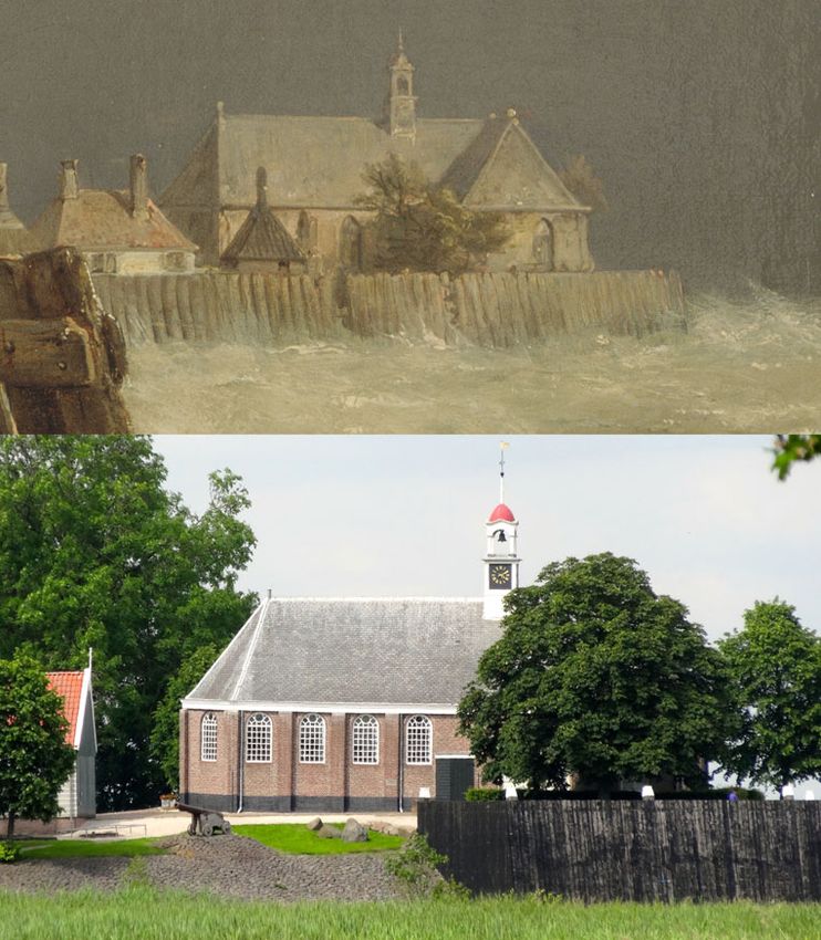
568                                                                           European Journal of Archaeology 22 (4) 2019

              Figure 1. Left: an impression of the Zuiderzee during the Battle on the Zuiderzee between the Dutch
              and Spanish fleet (Jan Theunisz, Blanckerhoff, 1663, Rijksmuseum Amsterdam). Right: the former
              Zuiderzee in the central part of the Netherlands (1), separated today from the North Sea by a large
              dam (2). The research presented in this article focuses on the Noordoostpolder region (3), which is part
              of the reclaimed province of Flevoland (hatched lines).
              Image of the Battle of the Zuiderzee reproduced by permission of the Rijksmuseum (available at
              https://www.rijksmuseum.nl/en/collection/SK-A-3235).

              Wieringermeerpolder,          Noordoostpolder,                     centuries, and in its heyday the island was
              Eastern Flevoland, and Southern Flevoland,                         inhabited by more than 600 people who
              of which the latter three constitute the prov-                     lived on three large artificial mounds
              ince of Flevoland. The reclamations dramat-                        (Geurts, 2005; Van Hezel & Pol, 2008;
              ically changed the nature and focus of the                         Van Popta & Aalbersberg, 2016). The
              region, from maritime to terrestrial and                           island suffered from many floods that
              from fishing to agriculture (Figure 2). The                        reduced its size and number of inhabitants.
              north-eastern part of the former Zuiderzee,                        For centuries, the Dutch government spent
              now known as the Noordoostpolder and                               much money on the island to maintain
              the study area presented here, clearly illus-                      the coastal defences and support its inhabi-
              trates these changes: the islands and coastal                      tants. In the second half of the nineteenth
              settlements became part of the mainland,                           century, it was decided to evacuate the
              leading to a substantial loss of the region’s                      island as the inhabitants were no longer
              maritime identity (Geurts, 2005: 263, 283).                        able to support themselves (Van Hezel &
                 A close examination of the present-day                          Pol, 2008: 201). Today, the island is unin-
              landscape of the Noordoostpolder shows                             habited, and only the lighthouse, church,
              that it is still possible to gain insights into                    an old quay, and several small fisherman’s
              the maritime past of the region. For                               cottages remind visitors of the once densely
              example, the former island of Schokland                            populated mounds.
              in the southern part of the region is now                             The example of Schokland is one of the
              completely surrounded by land, being an                            most obvious examples of ‘experiencing
              island on dry ground. Schokland was the                            the maritime past’ of the north-eastern
              home of the Schokker community for many                            Zuiderzee region. Other appropriate

Downloaded from https://www.cambridge.org/core. IP address: 46.4.80.155, on 22 Jan 2021 at 02:32:42, subject to the Cambridge Core terms of use, available at
https://www.cambridge.org/core/terms. https://doi.org/10.1017/eaa.2019.36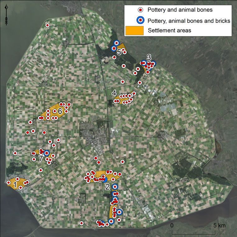
European Journal of Archaeology                                                                                              569

               Figure 2. The church of Ens on the island Schokland surrounded by the Zuiderzee in 1850 (painting
               by Hermanus Koekkoek, Zuiderzeemuseum) and photographed as it appears today.
               Painting of the church at Ens reproduced by permission of the Zuiderzeemuseum (available at
               https://www.zuiderzeecollectie.nl/object/collect/Zuiderzee_museum-4755).

               locations in the region are the past mari-                         accessible physical evidence of maritime
               time cultural centres (see Westerdahl,                             culture. The lower and larger part of the
               2013: 738), Urk island and seaports such                           ‘iceberg’ consists of evidence including
               as Kuinre, Vollenhove, or Blokzijl along                           pottery scatters, field boundaries, or
               the former eastern shore of the Zuiderzee.                         remains of dikes, and of historical maps
               These past ‘maritime cultural centres’ are                         and charters, place names, folklore, and
               the ‘tip of the iceberg’, being easily                             oral history. The analysis of these datasets

Downloaded from https://www.cambridge.org/core. IP address: 46.4.80.155, on 22 Jan 2021 at 02:32:42, subject to the Cambridge Core terms of use, available at
https://www.cambridge.org/core/terms. https://doi.org/10.1017/eaa.2019.36
570                                                                           European Journal of Archaeology 22 (4) 2019

              forms the core of the author’s doctoral                            before (Van den Biggelaar et al., 2014;
              research, which aims to gain a new and                             Vos, 2015; Pierik et al., 2016; Van Popta
              more accurate idea of the late medieval                            et al., in prep.).
              maritime cultural landscape of the                                    Even though it is commonly accepted
              Zuiderzee region. The objective of the                             that the Zuiderzee existed between
              present article, which stems from this                             approximately AD 1170 (the year of the
              project, is to recognize and characterize                          catastrophic All Saints’ Flood) and 1932
              the submerged and eroded cultural                                  (building of the Afsluitdijk), its dynamics
              remains, their locations, and their visibility                     changed over time. Parts of the peatlands
              in other sources. The discovery of remains                         that were mentioned by Mela in the first
              of the drowned late medieval settlement                            century AD still existed in the Middle
              of Fenehuysen (Fene = veen = peat, and                             Ages. The largest surfaces could be found
              huysen = huizen = houses) constitutes the                          in the north-eastern Zuiderzee region
              main result.                                                       (Van Popta, 2016). Recent research has
                                                                                 shown that large parts of these peatlands
                                                                                 were cultivated in the Middle Ages, but
               RESEARCH AREA: FROM THE ZUIDERZEE                                 that people were driven inland by the
                    TO THE NOORDOOSTPOLDER                                       water (Van Popta et al., in prep.).
                                                                                 Habitation was certainly possible on the
              The Noordoostpolder comprises the                                  known island of Urk (a Saalian boulder
              north-eastern part of the Zuiderzee                                clay outcrop), but probably also in other
              region: a large tidal lagoon of the North                          parts of the research area (Figure 4).
              Sea surrounded by inhabited peatlands. In                          Heavy storm surges in the thirteenth and
              Roman times, the region was described by                           fourteenth centuries eventually flooded
              Pomponius Mela (Chorographia III, 24) as                           and buried most of the medieval peat-
              an area of peatlands with multiple lakes:                          lands, leaving only small parts of Urk and
              Lacus Flevo. During this period, no                                Schokland exposed. The size of the
              marine influence affected the region. In                           Zuiderzee remained more or less stable
              the early Middle Ages, the name of the                             from the seventeenth century onwards
              region changed to Almere (all lakes), refer-                       (also because of the many dikes that were
              ring to even larger bodies of fresh water in                       constructed along the shore) until the con-
              the region (see Vos, 2015; Van Zijverden,                          struction of the Afsluitdijk in 1932. Large-
              2017). Human interference in the natural                           scale reclamations then transformed the
              landscape, in the form of cultivation and                          eastern part of the sea into land, and thus
              peat reclamation causing subsidence                                the province of Flevoland was created.
              through oxidation and erosion of the peat,
              is considered the main reason for the land-
              scape changes (Vos, 2015: 67). Massive                                                    APPROACH
              floods in the twelfth and thirteenth
              century AD eventually breached the peat                                  The maritime cultural landscape
              barrier that separated the Almere from the
              North Sea, resulting in the Zuiderzee                              The analysis of submerged late medieval
              (Figure 3; Pierik et al., 2016: 10; Van                            settlements in the Noordoostpolder region
              Popta et al., in prep.). As a consequence,                         fits the concept of the maritime cultural
              the North Sea reached the coastal plain                            landscape, as introduced by Scandinavian
              and started eroding peatland more often                            maritime archaeologist Christer Westerdahl
              and over more widespread areas than                                in the late 1980s and early 1990s

Downloaded from https://www.cambridge.org/core. IP address: 46.4.80.155, on 22 Jan 2021 at 02:32:42, subject to the Cambridge Core terms of use, available at
https://www.cambridge.org/core/terms. https://doi.org/10.1017/eaa.2019.36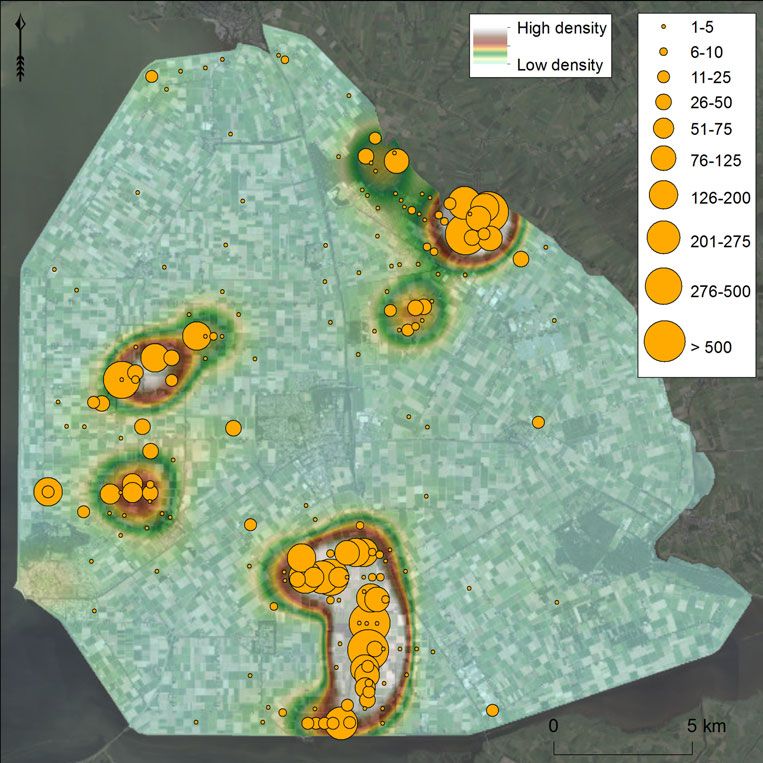
European Journal of Archaeology                                                                                              571

               Figure 3. Map of the Zuiderzee region, c. 1666. by Pieter Goos (Geheugen van Nederland). The circle
               marks the study area (Noordoostpolder region).
               Map reproduced by permission of Geheugen van Nederland / Koninklijke Bibliotheek (available
               at https://www.geheugenvannederland.nl/en/geheugen/view/zeekaart-zuiderzee-westelijke-wad-
               denzee-goos-pieter?coll=ngvn&maxperpage=36&page=1&query=Goos&identifier=NESA01%
               3AL17-0050).

               (Westerdahl, 1992, 2013; Duncan, 2006).                            constructions and other remains of human
               It was conceptualized to bridge the                                activity, underwater as well as terrestrial’
               boundaries between the terrestrial and                             (Westerdahl, 1992: 6; 2008: 212; 2011:
               maritime counterparts and relate maritime                          339; 2013: 744–45).
               culture to both. At first, the concept                                The notion of a maritime cultural land-
               focused only on the physical aspects of                            scape had a deep impact on maritime
               maritime culture like shipwrecks, harbours                         archaeology worldwide, as attested by
               and related structures (Westerdahl, 1978).                         numerous studies that followed in its foot-
               Soon, it was realized that the maritime cul-                       steps. However, as Duncan (2006) demon-
               tural landscape should be treated as a more                        strates, many studies claim to study the
               holistic concept, also including immaterial                        maritime cultural landscape while in fact
               and cognitive data under the following def-                        they only address part of it (in many cases
               inition: ‘The whole network of sailing                             the physical remains), making them arch-
               routes, with ports, havens and harbours                            aeological landscape studies rather than
               along the coast, and its related                                   maritime cultural landscape studies.

Downloaded from https://www.cambridge.org/core. IP address: 46.4.80.155, on 22 Jan 2021 at 02:32:42, subject to the Cambridge Core terms of use, available at
https://www.cambridge.org/core/terms. https://doi.org/10.1017/eaa.2019.36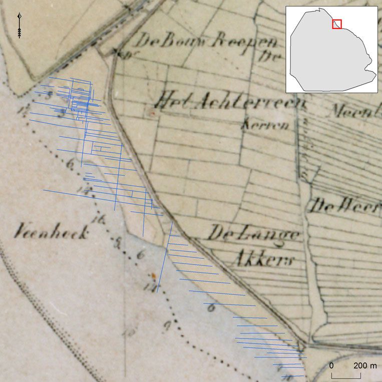
572                                                                           European Journal of Archaeology 22 (4) 2019

              Figure 4. Reconstruction of the north-eastern Zuiderzee region in medieval times (ad 1100). In grey:
              land (dark is settlement, light is submerged); white represents water. 1: Fenehuysen I; 2: Fenehuysen
              II; 3: Schokland; 4: Urk, 5: Kuinre.

              Furthermore, it is important to keep in                            geography, geology) are combined to
              mind that the datasets used are analysed                           retrieve the locations of late medieval sub-
              from a modern point of view. Past percep-                          merged settlements. The most important
              tions may differ: landscapes are multivalent,                      dataset is the Medieval Settlement
              and perceptions depend on perspective and                          Database of the Noordoostpolder (MSD):
              personal and communal experience (Ingold,                          it contains an overview of all late medieval
              1993; Westerdahl, 2004; Duncan, 2006).                             archaeological objects found in the
                                                                                 research area, primarily thousands of
                                                                                 pottery sherds, bricks, roof tiles, and
                                      Materials                                  animal bones. The data are compiled from
                                                                                 the Dutch National Archaeological
              In this article, datasets from several disci-                      Database (Archis), the archaeological
              plines (archaeology, (landscape) history,                          repository of the province of Flevoland,

Downloaded from https://www.cambridge.org/core. IP address: 46.4.80.155, on 22 Jan 2021 at 02:32:42, subject to the Cambridge Core terms of use, available at
https://www.cambridge.org/core/terms. https://doi.org/10.1017/eaa.2019.36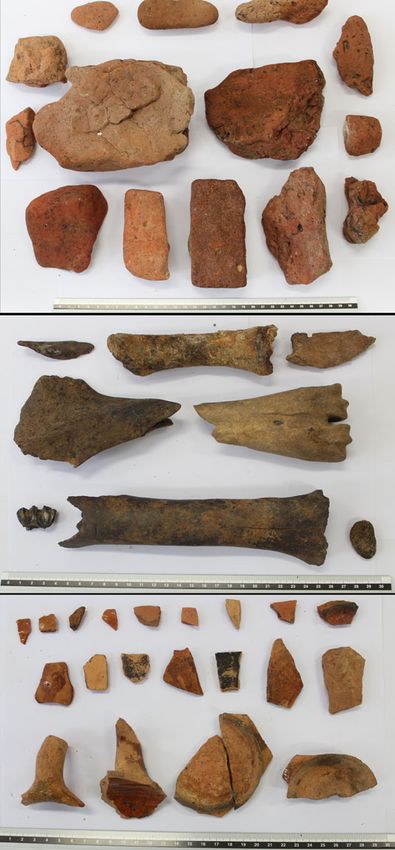
European Journal of Archaeology                                                                                              573

               archaeological distribution maps, and rele-                        Stavoren (province of Frisia). This charter
               vant archaeological literature such as the                         describes the possessions of the monastery
               archaeological series ‘Quarterly updates on                        (chapels and goods) in a region that encom-
               the Zuiderzee constructions’ (Ministerie                           passes the area of study (Mol & Van Vliet,
               van Verkeer en Waterstaat, 1920–1976).                             1998; Mol, 2011). Several sixteenth- and
               The latter source provides an overview of                          seventeenth-century historical maps (e.g.
               the earliest archaeological finds in the                           one of the oldest and quite accurate map of
               region encountered during the reclamation                          the entire Zuiderzee region made by
               works. The precise number of late medi-                            Christiaan Sgroten in 1573) provided
               eval archaeological objects in the entire                          further evidence about the final stages of
               region is unknown, as some primary                                 land erosion and settlement within the
               sources do not mention exact numbers.                              research area (Figures 3 and 4). One
               The distribution map made by the archae-                           should, however, keep in mind that these
               ologist Van der Heide, drawn in the                                maps depict the research area after the sub-
               1950s, and the oldest distribution map of                          mergence of many late medieval settle-
               the region, illustrate late medieval high-                         ments. Finally, modern remote sensing
               density areas, but lack quantities of                              datasets including (historical) aerial photo-
               objects. Furthermore, only part of the                             graphs, Digital Elevation Models, and satel-
               Archis database contains exact numbers of                          lite images were analysed for archaeological
               archaeological finds; in many cases, no                            traces such as historic dikes, ditches and
               quantitative information is given. It is                           mounds.
               known that many archaeological sites
               contain hundreds of late medieval objects
               and that several archaeological sites                                 Method: locating and characterizing
               contain over 2000 objects (lots NP 14 and                                  submerged settlements
               NP 23, based on records in repository of
               the province of Flevoland). It is expected                         The tens of thousands of late medieval
               that many other archaeological finds have                          objects in the MSD indicating human
               never been recorded because (1) they were                          presence in the Noordoostpolder region
               found by land owners who simply threw                              have been misinterpreted in the past as
               them away, (2) they were considered ‘arch-                         noise or as ships’ waste. This means that
               aeological noise’, or (3) they were found in                       late medieval settlement areas remain
               the early days of archaeological research in                       unrecognized, lack a protected status
               the Noordoostpolder when a recording                               (except Schokland and Urk) and are there-
               system had not yet been developed. In                              fore subject to severe anthropogenic dis-
               addition, hundreds of archaeological                               turbance (ploughing). To prevent further
               objects are found yearly by amateur                                damage to these sites and to pinpoint their
               archaeologists who search the arable fields                        locations, the current project determined
               after ploughing, indicating that similar late                      that several criteria must be met. If an
               medieval remains are still present in the                          archaeological findspot meets these cri-
               soil. To summarize, tens of thousands of                           teria, it can be labelled a late medieval
               late medieval objects have been discovered                         ‘settlement area’. First, a possible settle-
               in the Noordoostpolder and there are                               ment site has to contain multiple objects.
               many more objects preserved in situ.                               All isolated, single objects found in the
                  Several historical charters were also used,                     study area are disregarded: they cannot be
               including a copy of a thirteenth-century                           interpreted as settlement remains because
               charter of the St Odulphus monastery near                          the once inhabited lands have been highly

Downloaded from https://www.cambridge.org/core. IP address: 46.4.80.155, on 22 Jan 2021 at 02:32:42, subject to the Cambridge Core terms of use, available at
https://www.cambridge.org/core/terms. https://doi.org/10.1017/eaa.2019.36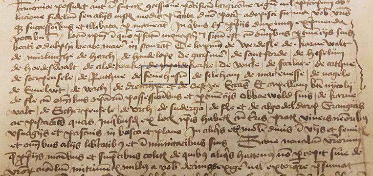
574                                                                           European Journal of Archaeology 22 (4) 2019

              disturbed by marine erosion, making it                             Noordoostpolder with a minimum number
              likely that small archaeological objects                           of six objects were selected from the
              were transported and redeposited. Second,                          MSD. The density of the archaeological
              the number of archaeological objects from                          records and objects from the MSD was
              a potential settlement site has to be sig-                         then analysed in ArcGIS, using Kernel
              nificantly higher (factor 10) than the                             Density and Point Density to highlight
              number of objects in the surrounding area.                         areas with a high findspot density
              In other words, the site must be visible as                        (Figure 5). Most of the archaeological
              a high-density area on an archaeological                           findspots contain at least some late medi-
              distribution map. Third, the composition                           eval pottery, typically late medieval wares
              of the archaeological objects representing a                       like Globular pottery, Pingsdorf ware,
              submerged settlement should be diverse                             Paffrath pottery, Andenne ware and
              and not limited to just pottery. There                             Proto-stoneware (Bartels, 2011). The
              should be a combination of sherds, animal                          majority of these sherds date to between
              bones, and preferably bricks and/or roof                           the twelfth and fourteenth century, which
              tiles. Especially the presence of bricks and                       implies that the settlements were built
              roof tiles should be considered a strong                           from AD 1100 onwards and were aban-
              indicator of former buildings. It is                               doned in the fourteenth century (though a
              assumed that regular late medieval houses                          more thorough study of these dates would
              in the research area were made of wood,                            be desirable). As said, it is the combin-
              and that important buildings such as a                             ation of materials that provides the stron-
              church or chapel were constructed from                             gest indication of the presence of a late
              stone (bricks or tufa). It is therefore                            medieval settlement. Therefore, an over-
              expected that the quantity of bricks and                           view was made of the sites that contain at
              roof tiles on medieval archaeological sites                        least two object categories, removing all
              is relatively low.                                                 sites that contain only one object category
                 This three-step-methodology led to the                          (Figure 6).
              creation of a map that indicates the pres-                             There are seven main settlement areas
              ence of all archaeologically recorded late                         that meet the criteria of a high-density area
              medieval settlement areas (see below). The                         with a varied composition of archaeological
              settlement areas on this map were com-                             material (see Figure 6). Three of these areas
              pared to historical sources (such as charters                      are well-known: they are the islands of Urk
              and maps) that provide information on                              (1) and Schokland (2), and the former
              their existence and location. Furthermore,                         coastal town of Kuinre (3). Four settlement
              remote sensing techniques were applied to                          areas in the research area represent
              possible site locations to document phys-                          unknown settlements. Two of them (4 and
              ical remains, and finally an archaeological                        5) are located in the direct vicinity of
              excavation was conducted at one settle-                            Kuinre, while the other two are to the north
              ment location with clear archaeological                            of Urk and Schokland. A copy of the thir-
              and historical traces.                                             teenth-century St Odulphus monastery
                                                                                 charter is of great importance, as it mentions
                                                                                 the names of almost 30 chapels and goods
                  RESULTS: SUBMERGED SETTLEMENTS                                 (settlements) in a clear geographical order
                                                                                 (Figure 7). Many of these names refer to
              In order to identify the location of late                          still existing settlements, except for Nagele,
              medieval submerged settlements, all late                           Marcnesse and Fenehuysen, which should
              medieval archaeological findspots in the                           be located within the study area according

Downloaded from https://www.cambridge.org/core. IP address: 46.4.80.155, on 22 Jan 2021 at 02:32:42, subject to the Cambridge Core terms of use, available at
https://www.cambridge.org/core/terms. https://doi.org/10.1017/eaa.2019.36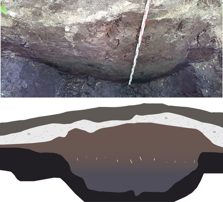
European Journal of Archaeology                                                                                              575

               Figure 5. Combined archaeological density and distribution map, based on the content of the MSD
               database.

               to the geographical order. The charter does                        corruption of Fenehuysen) twice: one loca-
               not mention the exact location of these set-                       tion corresponds to settlement area 5 along
               tlements, hence the oldest historical maps of                      the coast, the second is written on the
               the study area needed to be checked. The                           waters south of Kuinre. Above this name,
               name Fenehuysen, meaning ‘houses on                                there is a small icon of a building (probably
               peat’, appears on multiple historical maps of                      a church) sticking out of the water. The
               the Zuiderzee region (the oldest dates to                          information from this map is of great
               1573). The settlement is shown in these                            importance as it not only depicts a sub-
               maps along the coast of the Zuiderzee, to                          merged settlement, but also shows that
               the north-west of Kuinre. This location                            Fenehuysen has shifted inland due to rewet-
               matches the archaeological data and corre-                         ting and erosion of the peatlands (De Bont,
               sponds to archaeological settlement area                           2008). The location of submerged
               5. Interestingly, a seventeenth-century map                        Fenehuysen corresponds directly with the
               mentions the name Veenhuijsen (a                                   archaeological settlement area 4. The names

Downloaded from https://www.cambridge.org/core. IP address: 46.4.80.155, on 22 Jan 2021 at 02:32:42, subject to the Cambridge Core terms of use, available at
https://www.cambridge.org/core/terms. https://doi.org/10.1017/eaa.2019.36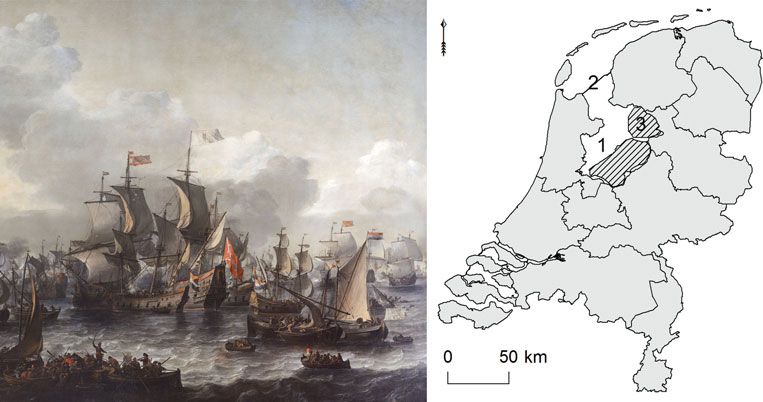
576                                                                           European Journal of Archaeology 22 (4) 2019

              Figure 6. Distribution map of archaeological finds, only showing sites that contain at least two
              object categories.

              Nagele and Marcnesse are not mentioned                             However, the fifth settlement-area, that of
              on any of the historical maps, but it is pos-                      Fenehuysen, had been turned into forest
              sible that they belong to settlement areas                         directly after the reclamations, leaving the
              north of Urk and Schokland (areas 6 and 7).                        former seabed largely intact. Therefore, this
                 Further examination of the four                                 settlement area was considered most suitable
              unknown settlement areas through the ana-                          for further in-depth research.
              lysis of remote sensing datasets (aerial
              photographs, satellite images, and LiDAR
              data) did not reveal new evidence for three                             Finding Fenehuysen: physical and
              locations (4, 6, and 7). Extensive ploughing                                  immaterial evidence
              has levelled the former seabed and thor-
              oughly disturbed the archaeological remains,                       The first evidence for the existence and
              leaving only dense scatters of archaeological                      location of the drowned settlement of
              objects on the surface in these areas.                             Fenehuysen came from the late medieval

Downloaded from https://www.cambridge.org/core. IP address: 46.4.80.155, on 22 Jan 2021 at 02:32:42, subject to the Cambridge Core terms of use, available at
https://www.cambridge.org/core/terms. https://doi.org/10.1017/eaa.2019.36
European Journal of Archaeology 577
Figure 7. Fifteenth-century copy of a thirteenth century charter of the St Odulphus monastery that
mentions Fenehuysen (outlined in rectangle).
charter of the St Odulphus monastery. is more promising as it is depicted on
The list of names in the charter has a geo- several sixteenth-century maps near the
graphical order, suggesting that the settle- north-eastern shore of the Zuiderzee in an
ment was located somewhere between the area that is nowadays covered by the
eastern shore of the Zuiderzee and Urk Kuinder forest. No clear concentrations of
island. The spatial distribution of the late medieval archaeological objects were
objects from the MSD helped pinpoint found in the forest, but this could also be
settlement locations in the study area. the result of limited soil disturbance since
Further evidence came from the sixteenth- the reclamations. Other datasets were con-
century maps of the Zuiderzee region, sulted for evidence of medieval habitation
which show two locations for Fenehuysen. and land cultivation. The first category of
The locations on the historical maps cor- evidence came from the analysis of aerial
respond closely with settlement areas 4 photographs. The oldest consulted were
and 5. Settlement area 4 is interpreted as made by the Royal Air Force (RAF)
the first location of Fenehuysen, lying on during the Second World War; they show
the south-eastern tip of a large peatland the settlement area after the reclamations
peninsula in the north-eastern part of the but before forestation. Some northwest-
research area. Based on pottery finds, it is southeast oriented linear discolorations are
estimated that the settlement was sub- visible on these photographs, stretching
merged before AD 1400 and that its inhabi- along a part of the eastern shore of the
tants moved further inland. Due to intensive Zuiderzee that includes settlement area
marine erosion, modern ploughing, and peat 5. More recent aerial photographs did not
compaction, no in situ physical evidence is add to this, as they only depict the tree-
expected on the present-day location of the tops of the forest. But more advanced
site. Nevertheless, this settlement area is remote sensing methods allow us to create
interpreted as the origin of Fenehuysen and Digital Elevation Models (DEMs) of the
therefore called Fenehuysen I. forest soil by using LiDAR (Airborne
The second location of the settlement Light Detection and Ranging; Davis,
(area 5), now referred to as Fenehuysen II, 2008). Detailed LiDAR footage of the
Downloaded from https://www.cambridge.org/core. IP address: 46.4.80.155, on 22 Jan 2021 at 02:32:42, subject to the Cambridge Core terms of use, available at
https://www.cambridge.org/core/terms. https://doi.org/10.1017/eaa.2019.36578 European Journal of Archaeology 22 (4) 2019
Kuinder forest soil not only confirmed the the Zuiderzee phase (Late Middle Ages to
presence of the linear structures that were c. AD 1942; Wiggers, 1955).
spotted on the aerial photographs of the Studying the sections of the eight test
RAF but also revealed far more of these trenches clearly revealed the nature of the
structures on the forest soil, which modern linear structures: they represent a network
aerial photographs and satellite images of ditches that were dug into the peat
could not detect. Further analysis of the before the area was overtaken by the
LiDAR data revealed that one particular Zuiderzee. The linear structures, slightly
area of the forest, corresponding to the higher than their surroundings, represent
historical site of Fenehuysen II, contains a the lowest parts of the organic clayey sedi-
dense network of linear and rectangular ments deposited in the ditches before the
structures with a slightly higher elevation major marine erosion of the Zuiderzee
than the surroundings (a difference of c. started (Figure 9). During the Zuiderzee
30–50 cm in height). These traces had phase, major parts of the peatlands in the
not been noticed before and were therefore study area were flooded and/or washed
of interest for further archaeological away. The natural stratigraphy in the exca-
research (Figure 8). What exactly do they vation area shows that the lower parts of
represent, and would an archaeological the peatlands have survived, i.e. the
excavation reveal the remains of Zuiderzee has only washed away the top of
Fenehuysen II? the peat layer. It also means that the exact
dimensions of the ditches could not be
documented as only the deepest parts were
Archaeological excavation preserved. After the Zuiderzee had taken
hold of the area, marine sediments were
In May and June 2017, archaeological deposited on top of the remaining peat and
investigations by the University of the clayey fill (fresh water deposits) of the
Groningen were conducted in the area ditches. After the reclamation of the north-
with dense linear structures in the Kuinder eastern Zuiderzee, a continuous process of
forest. The excavation consisted of eight dehydration and oxidation of the former
test trenches, varying in length from 2 to seabed started. It caused soil compaction,
8 m, dug through a selection of linear especially for the layers of peat that
structures. The purpose was to analyse and remained after the marine phase in the
document their sections. In addition, over region. The weight of the clayey fill of
30 cores were taken throughout the exca- the ditches had already compacted the
vation area to obtain information on the underlying peat before and during the
natural stratigraphy and to compare Zuiderzee phase, creating a clear contrast
the natural stratigraphy with sections of between the ditches (limited compaction)
the linear structures. GPS and a Total and their surroundings (more substantial
Station were used for locating the linear compaction). As a result, an inversion of
structures, although many could be relief occurred: the ditches became visible
spotted with the naked eye. All trenches on LiDAR as small elevations in the
were dug through the Holocene sediments landscape.
into the Pleistocene subsoil. In general, Several large ditches can be distin-
the Holocene substrate of this region con- guished from the other ditches, based on
sists of a thick layer of peat (the top dates their greater width (5–6 m) and north-
to the Middle Ages), covered by different west-southeast-orientation. Interestingly,
layers of sandy and clayey sediments from these larger ditches have the same
Downloaded from https://www.cambridge.org/core. IP address: 46.4.80.155, on 22 Jan 2021 at 02:32:42, subject to the Cambridge Core terms of use, available at
https://www.cambridge.org/core/terms. https://doi.org/10.1017/eaa.2019.36European Journal of Archaeology 579
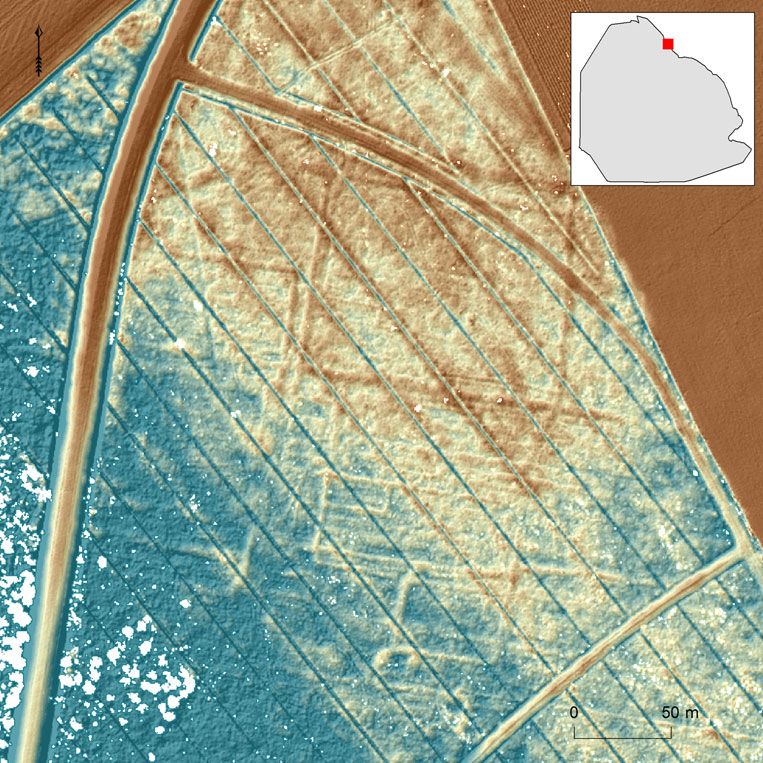
Figure 8. A dense network of linear structures is visible on the LiDAR data of the Kuinder Forest
surface. The northwest-southeast oriented blue lines are modern drainage ditches (blue is low, red is
high).
orientation as the old network of inland barn. The clayey substrate of numerous
ditches visible on historical maps and ditches contained large amounts of arch-
LiDAR data (Figure 10). It suggests that aeological material, consisting of yellow
the ditches in the excavation area were and red bricks, pottery and stoneware
part of a larger system of field boundaries sherds, animal bones with butchery marks,
that served to drain the peatlands on burnt daub, peat bricks, and rye pollen
which Fenehuysen II was built. Although (Figure 11). The presence of the latter
no intact remains of the settlement have indicates that rye, one of the most fre-
yet been found, several rectangular areas quently grown medieval cereals in the
(measuring c. 30 × 15m) were surrounded Netherlands, was also grown on the peaty
by small ditches. There is a good chance soils near Fenehuysen II (Van Geel et al.,
that these represent small medieval farm- 1983; Behre, 1992; Ettema, 2005). The
steads with space for a single house or assemblage clearly represents settlement
Downloaded from https://www.cambridge.org/core. IP address: 46.4.80.155, on 22 Jan 2021 at 02:32:42, subject to the Cambridge Core terms of use, available at
https://www.cambridge.org/core/terms. https://doi.org/10.1017/eaa.2019.36580 European Journal of Archaeology 22 (4) 2019
Figure 9. Photograph and drawing of a section of one of the test trenches dug through a historical ditch
in the Kuinder forest.
noise as described in the methods section survive in situ. Only the deepest parts of
above. It is assumed that the objects were features like wells and pits might still be
either deposited in the ditches on purpose present. Past and present archaeological
(waste) or deposited in the ditches by the research has shown that in some parts of
eroding force of storm floods. As the test the north-eastern Zuiderzee region people
trenches only targeted the ditches, no lived on small artificial mounds
information is available for the small areas (Schokland island) and protected them-
enclosed by the ditches. Several other selves against the water by constructing
ditches with almost no archaeological dikes. It remains unclear whether this also
objects must represent ditches that were goes for Fenehuysen II: some dike remains
further away from the farmsteads. Clearly, (discolorations on aerial photographs) have
more archaeological research is required to been found to the north-west of the
find out whether in situ remains, presum- former settlement, but there is no evidence
ably belonging to Fenehuysen II, are still that proves the presence of mound
present. As the top of the peat was remains (see Van Popta, 2017).
washed away by the Zuiderzee, it is The main category of archaeological
unlikely that the foundations of houses objects consists of pottery sherds and
Downloaded from https://www.cambridge.org/core. IP address: 46.4.80.155, on 22 Jan 2021 at 02:32:42, subject to the Cambridge Core terms of use, available at
https://www.cambridge.org/core/terms. https://doi.org/10.1017/eaa.2019.36European Journal of Archaeology 581
Figure 10. Overview of the boundary system in the Kuinder forest (blue lines) and the historical
inland field system depicted on the 1850 Topographical Military Map.
bricks. The earliest sherds (Globular different ages, had clear butchery marks,
pottery, Paffrath pottery) date to the Late indicating that they are consumption
Middle Ages, while the latest sherds date waste. Altogether, the assemblage in the
to the seventeenth century (redware, early ditches represents the leftovers of a settle-
stoneware). No intact object was found, ment that was threatened by marine
but many sherds belong to jars and plates. erosion. As only small parts of the ditches
The bricks are either yellow or red and have been examined, many more objects
some have a rounded surface owed to remain in the clayey fill of the ditches.
water erosion. These bricks, together with
fragments of burnt daub, are likely to
represent the remains of buildings in A shifting settlement
Fenehuysen II. The ditches also contained
a relatively large number of animal bones. The history of the submerged settlement
Many bones, mainly belonging to cattle of Fenehuysen highlights the dynamic nature
Downloaded from https://www.cambridge.org/core. IP address: 46.4.80.155, on 22 Jan 2021 at 02:32:42, subject to the Cambridge Core terms of use, available at
https://www.cambridge.org/core/terms. https://doi.org/10.1017/eaa.2019.36582 European Journal of Archaeology 22 (4) 2019
Figure 11. A selection of archaeological finds from the clayey fill of the late medieval ditches. From top
to bottom: bricks, animal bones, red ware.
Downloaded from https://www.cambridge.org/core. IP address: 46.4.80.155, on 22 Jan 2021 at 02:32:42, subject to the Cambridge Core terms of use, available at
https://www.cambridge.org/core/terms. https://doi.org/10.1017/eaa.2019.36European Journal of Archaeology 583
of the north-eastern Zuiderzee region and mention the existence of five farms in
the erosive force of the Zuiderzee. 1763 and one remaining farm in 1793
Historical maps confirm that the coastal (Kamman, 1985: 80). The topographical
settlement, referred to here as Fenehuysen maps of 1850 and thereafter no longer
II, lies along the former Zuiderzee coast, mention the name Fenehuysen, although
northwest of Kuinre. Archaeological inves- the descriptions Achterveen (behind peat)
tigations have shown that the remains of and Veenhoek (peat corner) have been used
this settlement can be found in the in the vicinity of Fenehuysen III (for topo-
Kuinder forest, corresponding to settlement nyms, see the Topographical Military
area 5 (Figure 6). Fenehuysen I was, Map of 1850 and the Bonnebladen maps
according to a seventeenth-century map, of the nineteenth–twentieth century).
located to the south of Kuinre and corre- Now, all that remains of Fenehuysen III is
sponds to archaeological settlement area a small circular elevation in the fields, also
4. Fenehuysen I was inhabited until the visible on nineteenth-century maps. This
fourteenth century, as indicated by the site has not yet been archaeologically
dates of pottery sherds from that site. examined, although local people claim to
Fenehuysen II is estimated to have been have found sherds and bricks on the
inhabited between AD 1300 and 1700, also surface. Archaeological investigations on
based on the dates of pottery sherds and this site may indeed reveal the final
stoneware fragments. Combining these remains of Fenehuysen.
archaeological and historical results leads to The shifting nature of Fenehuysen is but
the following reconstruction (Figure 12): one example of late medieval shifting settle-
the first site of Fenehuysen was left to the ments. There are more settlements in the
mercy of the waves in the fourteenth Netherlands, such as Rouveen, Staphorst,
century. There might even be a specific Elburg and even the nearby castle of
event responsible for the destruction of Kuinre, which experienced a similar shift
Fenehuysen I: on 10 October 1375, a for several reasons (search for dry land or
massive storm hit the coasts of the North fertile grounds; see Bos, 1988; Spek et al.,
Sea, Wadden Sea, and Zuiderzee 1996; De Boer & Geurts, 2002). The same
(Buisman, 1996). As a consequence, the goes for the reclaimed lands of the
inhabitants moved further north (inland) Noordoostpolder, in which the remains of
and founded Fenehuysen II. Both settle- submerged settlements were found; there
ments must have had a small church or are more examples of reclaimed lands in
chapel, as mentioned in the historical char- the Netherlands (e.g. the Beemster,
ters and maps. The bricks found at the site Scheemer, and Purmer polders) and else-
of Fenehuysen II could have belonged to where (e.g. De Polders in Belgium and
such a structure. Nordstrand in Germany). In addition,
The second settlement was abandoned remains of medieval and early modern sub-
in the seventeenth century and the inhabi- merged settlements can be found in other
tants of Fenehuysen II started living parts of the Netherlands, like northern
behind the dikes at Fenehuysen III. This Frisia and Groningen (many artificial
is illustrated on eighteenth- and nine- settlement mounds), Zeeland (Verdronken
teenth-century maps. During this period, land van Saefthinge and Reimerswaal), and
the word Fenehuysen was still used as a further afield (e.g. Jomsborg and Vineta).
place-name, but its appearance must have However, the Noordoostpolder should be
been that of a hamlet: a couple of farms considered a unique landscape due to the
spread in the landscape. Historical archives combination of aspects presented here.
Downloaded from https://www.cambridge.org/core. IP address: 46.4.80.155, on 22 Jan 2021 at 02:32:42, subject to the Cambridge Core terms of use, available at
https://www.cambridge.org/core/terms. https://doi.org/10.1017/eaa.2019.36584 European Journal of Archaeology 22 (4) 2019
Figure 12. Reconstruction of the shifting nature of Fenehuysen. Brown: peatland; green: drowned
peatland; orange: settlement remains: blue: water; grey: dikes.
CONCLUSION tested by searching for the submerged his-
toric settlement of Fenehuysen. Although
The discovery of the late medieval network the datasets consulted are of a different
of ditches that contained the settlement nature, the innovative use of spatial and
remains of Fenehuysen II demonstrates predictive analysis by GIS proved effective
that an interdisciplinary and methodo- in the interpretation of the anthropogenic
logical approach within the maritime cul- traces discovered in the Kuinder forest.
tural landscape concept can be rewarding. These traces, forming small rectangular
This maritime cultural landscape consists of entities, are interpreted as a late medieval
many invisible physical remains like buried network of ditches that contained relatively
archaeological objects and a large number numerous archaeological objects, clearly
of immaterial aspects including place representing settlement noise. They belong
names, information on historical records to the second settlement of Fenehuysen that
and charters, palaeo-geographic interpreta- existed roughly between AD 1300 and 1700.
tions and individual perception based on a The first settlement, discovered further
specific perspective. Instead of merely south, was in existence until the fourteenth
focusing on archaeological data, an analysis century. Fenehuysen was built for a third
of multiple kinds of data proved valuable. time to the north-west of the second settle-
The aim of this paper has been to rec- ment and was almost completely abandoned
ognize and characterize the submerged by the end of the eighteenth century.
and eroded cultural remains in the The settlement of Fenehuysen II needs
Noordoostpolder region. Multiple criteria to be explored further. Excavating the
for identifying submerged settlements rectangular potential farmsteads in the
among the large number of archaeological Kuinder forest may show whether settle-
objects from the region were defined and ment remains like wells, pits, and
Downloaded from https://www.cambridge.org/core. IP address: 46.4.80.155, on 22 Jan 2021 at 02:32:42, subject to the Cambridge Core terms of use, available at
https://www.cambridge.org/core/terms. https://doi.org/10.1017/eaa.2019.36European Journal of Archaeology 585
foundations have survived in situ. There Nijmegen en Tiel (1250–1900). Zwolle:
are also other settlements mentioned in Spa Uitgevers B.V.
historical charters like Marcnesse and Behre, K-E., 1992. The History of Rye
Cultivation in Europe. Vegetation History
Nagele that drowned in the north-eastern and Archaeobotany, 1: 141–56.
Zuiderzee region (Mol, 2011; Van Popta Bos, J.M. 1988. Landinrichting en archeologie:
et al., in prep.). Finding them may be even het bodemarchief van Waterland (NAR 6).
harder as much of the area is heavily eroded Amersfoort: Rijksdienst voor het
and disturbed. Remote sensing and arch- Oudheidkundig Bodemonderzoek.
Buisman, J. 1996. Duizend jaar weer, wind en
aeological research might not be sufficient, water in de Lage landen 2. 1300–1450.
but historical records and maps, when thor- Franeker: Uitgeverij Van Wijnen.
oughly examined, can help pinpoint the Davis, O. 2008. Processing and Working with
locations of settlements and provide further LiDAR Data in ArcGIS: A Practical Guide
information on their existence. for Archaeologists. Aberystwyth: Royal
Commission on the Ancient and
To conclude: the existence of the Historical Monuments of Wales.
Zuiderzee has influenced the life of people De Boer, P.C. & Geurts, A.J. 2002. Oude
who inhabited the peatlands on which burchten in het nieuwe land. De midde-
Fenehuysen was founded. Storm surges leeuwse kastelen van Kuinre in de
and tidal activity constantly threatened the Noordoostpolder. Lelystad: Stichting
Uitgeverij de Twaalfde Provincie.
small and vulnerable settlements, leaving
De Bont, C. 2008. Vergeten land. Ontginning,
their inhabitants no other option than to bewoning en waterbeheer in de westneder-
move further inland. This study illustrates landse veengebieden (800–1350). PhD dis-
the force of the Zuiderzee and its influ- sertation, Wageningen University.
ence on the late medieval lands: clearly ‘no Duncan, B.G. 2006. The Maritime Archaeology
country for men’ (to borrow from the and Maritime Cultural Landscapes of
Queenscliffe: A Nineteenth Century
book and film title). Australian Coastal Community.
Unpublished PhD dissertation, James
Cook University, Queensland, Australia.
Ettema, W. 2005. Boeren op het Veen. Een
ACKNOWLEDGEMENTS
ecologisch-historische benadering (1000–
1500). Holland, 1: 239–58.
This work was supported by the Dutch Geurts, A.J. 2005. Urk. De geschiedenis van een
Organization for Scientific Research (NWO; eiland. Lelystad: Nieuw Land
PhDs in Humanities, file no. 322-60-006) Erfgoedcentrum.
and is part of the author’s doctoral research. Ingold, T. 1993. The Temporality of
Landscape. World Archaeology, 25: 152–74.
I would like to thank Bas van Geel, Stijn Kamman, R. 1985. Geschiedenis van Kuinre en
Arnoldussen and an anonymous reviewer for omgeving. Hoogersmilde: Grafiplan.
their insightful comments. I am also grateful Ministerie van Verkeer en Waterstaat. 1920–
to Robert McKenzie, Sander Tiebackx, and 1976. Driemaandelijks bericht betreffende de
Harold Broekmans for their support. Finally, Zuiderzeewerken. Den Haag: Ministerie
van Verkeer en Waterstaat.
I would like to thank the students of the Mol, J.A. 2011. De middeleeuwse veenontgin-
University of Groningen who participated in ningen in Noordwest-Overijssel en Zuid-
the Kuinderbos excavation. Friesland: datering en fasering. Jaarboek
voor Middeleeuwse Geschiedenis, 14: 46–90.
Mol, J.A. & Van Vliet, K. 1998. De oudste
oorkonden van het Sint-Odulfusklooster
REFERENCES van Staveren. Jaarboek voor Middeleeuwse
Geschiedenis, 1: 73–134.
Bartels, M. 2011. Steden in scherven. Vondsten Pierik, H.J., Cohen, K.M., Vos, P.C., Van der
uit beerputten in Deventer, Dordrecht, Spek, A.J.F. & Stouthamer, E. 2016. Late
Downloaded from https://www.cambridge.org/core. IP address: 46.4.80.155, on 22 Jan 2021 at 02:32:42, subject to the Cambridge Core terms of use, available at
https://www.cambridge.org/core/terms. https://doi.org/10.1017/eaa.2019.36586 European Journal of Archaeology 22 (4) 2019
Holocene Coastal-plain Evolution of the Van Popta, Y.T., Westerdahl, C.L. &
Netherlands: The Role of Natural Duncan, B.G. 2019. Maritime Culture in
Preconditions in Human-induced Sea the Netherlands: Accessing the Late
Ingressions. Proceedings of the Geologists’ Medieval Maritime Cultural Landscapes
Association, 128: 180–97. of the North-Eastern Zuiderzee.
Spek, M., Zeiler, F.D. & Raap, E. 1996. Van International Journal of Nautical
de Hunnepe tot de zee; de geschiedenis van Archaeology, 48: 172–88. https://doi.org/
het Waterschap Salland. Kampen: 10.1111/1095-9270.12333.
IJsselacademie. Van Popta, Y.T., Cohen, K.M., Vos, P.C. &
Van den Biggelaar, D.F.A.M., Kluiving, S.J., Spek, M. in prep. Reconstructing Eroded
Van Balen, R.T., Kasse, C., Troelstra, S. Medieval Landscapes: An Interdisciplinary
R. & Prins, M.A. 2014. Storms in a Palaeogeographical Approach to the
Lagoon: Flooding History during the Last Maritime Cultural Landscape of the
1200 Years Derived from Geological and Noordoostpolder (Zuyder Zee area, The
Historical Archives of Schokland Netherlands) between A.D. 1100 and
(Noordoostpolder, The Netherlands). 1400. Journal of Landscape History.
Netherlands Journal of Geosciences, 93: 175– Van Zijverden, W.K. 2017. After the Deluge. A
96. Palaeogeographical Reconstruction of Bronze
Van Geel, B., Hallewas, D.P. & J.P. Pals Age West-Frisia (2000–800 bc). PhD dis-
1983. A Late Holocene Deposit under the sertation, Leiden University.
Westfriese Zeedijk near Enkhuizen (Prov. Vos, P.C. 2015. Origin of the Dutch Coastal
of Noord-Holland, the Netherlands): Landscape. Long-term Landscape Evolution
Palaeoecological and Archaeological of the Netherlands during the Holocene
Aspects. Review of Palaeobotany and Described and Visualized in National,
Palynology, 39: 269–335. Regional and Local Palaeogeographical Map
Van Hezel, G. & Pol, A. 2008. Schokland en Series. PhD dissertation, Utrecht
omgeving. Leven met water. Utrecht: Matrijs. University.
Van Holk, A.F.L. 2017. The Zuiderzee (the Westerdahl, C.L. 1978. Marinarkeologisk
Netherlands). Highway, Fishing Ground inventering med utgångspunkt från ett
and Power Landscape. In: J. Gawronski, norrlåndskt exempel. C-uppsats, Arkeologi.
A.F.L. van Holk & J. Schokkenbroek, Unpublished PhD dissertation, University
eds. Ships and Maritime Landscapes. of Stockholm.
Proceedings of the Thirteenth International Westerdahl, C.L. 1992. The Maritime
Symposium on Boat and Ship Archaeology, Cultural Landscape. The International
Amsterdam 2012. Eelde: Barkhuis, pp. 73– Journal of Nautical Archaeology, 21: 5–14.
78. Westerdahl, C.L. 2004. Maritime Cultures
Van Popta, Y.T. 2016. Taken by the Sea. and Ship Types: Brief Comments on the
New Analyses on the Dynamic Past of the Significance of Maritime Archaeology. The
Maritime Cultural Landscape Known as International Journal of Nautical
the Former Zuiderzee (the Netherlands). Archaeology, 23: 265–70.
Cambridge Archaeological Review, 31: 75–90. Westerdahl, C.L. 2008. Fish and Ships.
Van Popta, Y.T. 2017. Opgespoorde sporen Towards a Theory of Maritime Culture.
van bewoning. Een archeologische, histor- Deutsches Schiffahrtsarchiv,
ische en geografische interpretatie van het Wissenschaftliches Jahrbuch des Deutschen
laatmiddeleeuwse landschap van de Schiffahrtsmuseums, 30: 191-236.
Noordoostpolder. Tijdschrift voor Westerdahl, C.L. 2011. The Maritime
Historische Geografie, 2: 130–43. Cultural Landscape Revisited. In: B. Ford,
Van Popta, Y.T. & Aalbersberg, G. 2016. ed. The Archaeology of Maritime
Onbekend maar niet onbemind: terpen en Landscapes. New York: Springer, pp. 331–
terponderzoek in de Noordoostpolder. In: 44.
A. Nieuwhof, ed. Van Wierhuizen tot Westerdahl, C.L. 2013. The Maritime
Achlum. Honderd jaar archeologisch onder- Cultural Landscape. In: A. Catsambis, B.
zoek in terpen en wierden. Groningen: Ford & D.L. Hamilton, eds. The Oxford
Vereniging voor Terpenonderzoek, pp. Handbook of Maritime Archaeology. Oxford:
129–40. Oxford University Press, pp. 733–62.
Downloaded from https://www.cambridge.org/core. IP address: 46.4.80.155, on 22 Jan 2021 at 02:32:42, subject to the Cambridge Core terms of use, available at
https://www.cambridge.org/core/terms. https://doi.org/10.1017/eaa.2019.36European Journal of Archaeology 587
Wiggers, A.J. 1955. De wording van het started his NWO-funded PhD research
Noordoostpoldergebied. Een onderzoek naar on the late medieval maritime cultural
de physisch-geografische ontwikkeling van een landscape of the Zuiderzee region in the
sedimentair gebied. Zwolle: Tjeenk Willink.
Netherlands, combining data from arch-
aeological, geological, historical, and geo-
graphical sources in a spatial environment.
BIOGRAPHICAL NOTES
Address: Institute of Archaeology,
Yftinus van Popta is a PhD student in
University of Groningen, Poststraat 6,
maritime archaeology at the University of
9712 ER Groningen, The Netherlands.
Groningen. After specializing in maritime
[email: y.t.van.popta@rug.nl]
archaeology during his Master’s degree, he
Pas un pays pour des hommes : à la recherche des habitats submergés de la fin du
Moyen Age dans le nord-est du Zuiderzee au Pays–Bas
Cet article traite du paysage culturel maritime autrefois recouvert par le Zuiderzee (1170–1932 apr.
J.-C.) au centre des Pays-Bas. Depuis l’assèchement à grande échelle des terres gagnées sur la mer
(1932–1968), de nombreux vestiges ont révélé une culture maritime submergée et érodée sous forme
d’îles disparues, d’habitats submergés, d’anciens terroirs, d’épaves et de réseaux socio-économiques
évanouis. Le secteur nord-est de cette région en particulier, connu sous le nom de Noordoostpolder,
témoigne des luttes que les Néerlandais ont mené contre la mer. L’examen des données physiques et
autres provenant de cette région permet de donner une idée de cet espace culturel maritime à la fin du
Moyen Age en comparant la répartition et de la densité des vestiges aux données livrées par les docu-
ments historiques et aux résultats de la télédétection. Cette approche interdisciplinaire a mené à la
découverte d’un habitat submergé à Fenehuysen. Translation by Madeleine Hummler
Mots-clés: habitats submergés, fin du Moyen Age, Zuiderzee, paysage culturel maritime,
Fenehuysen, Pays-Bas
Kein Land für Menschen: auf der Spur von spätmittelalterlichen überschwemmten
Siedlungen in der nordöstlichen Zuiderzee Gegend in den Niederlanden
Dieser Artikel betrifft die maritime Kulturlandschaft der ehemaligen Zuiderzee (ca. 1170–1932
n. Chr.) in der Mitte der heutigen Niederlande. Seit der umfangreichen Landgewinnung vom Meer
(1932–1968) sind zahlreiche Überreste zutage gekommen; diese Spuren lassen eine überschwemmte und
erodierte spätmittelalterliche Kulturlandschaft erkennen, in der Form von verschwundenen Inseln,
überschwemmte Siedlungen, ehemaliger Ackerbau, Schiffbrüche, also sozioökonomische Netzwerke.
Besonders im nordöstlichen Teil dieser Gegend, heute als Noordoostpolder bekannt, gibt es Belege der
dynamischen Kämpfe der Niederländer gegen die Macht des Meeres. Die Untersuchung der materiellen
und immateriellen Daten aus der Gegend gibt uns einen Einblick in diese spätmittelalterliche maritime
Kulturlandschaft. Die Untersuchung der Verbreitung und Dichte der spätmittelalterlichen Funde und
der Vergleich dieser Streuung mit historischen Quellen und mit Fernerkundungsergebnissen haben dazu
geführt, die Spuren einer überschwemmten Siedlung in Fenehuysen zu entdecken. Translation by
Madeleine Hummler
Stichworte: überschwemmte Siedlungen, Spätmittelalter Ages, Zuiderzee, maritime
Kulturlandschaft, Fenehuysen, Niederlande
Downloaded from https://www.cambridge.org/core. IP address: 46.4.80.155, on 22 Jan 2021 at 02:32:42, subject to the Cambridge Core terms of use, available at
https://www.cambridge.org/core/terms. https://doi.org/10.1017/eaa.2019.36You can also read