Western Mareotis lake(s) during the Late Holocene (4th century BCE-8th century CE): diachronic evolution in the western margin of the Nile Delta ...
←
→
Page content transcription
If your browser does not render page correctly, please read the page content below
Research article
E&G Quaternary Sci. J., 70, 39–52, 2021
https://doi.org/10.5194/egqsj-70-39-2021
© Author(s) 2021. This work is distributed under
the Creative Commons Attribution 4.0 License.

Western Mareotis lake(s) during the Late Holocene (4th century
BCE–8th century CE): diachronic evolution in the western
margin of the Nile Delta and evidence for the digging
of a canal complex during the early Roman period
Maël Crépy1 and Marie-Françoise Boussac2
1 UMR5133   Archéorient and UMR5189 HiSoMA, Maison de l’Orient et de la Méditerranée, CNRS, Lyon 69007, France
2 UMR7041   ArScAn, Université Paris Nanterre, 21 allée de l’Université, 92023 Nanterre, France

Correspondence:        Maël Crépy (crepy.mc@gmail.com)

Relevant dates:        Received: 25 September 2020 – Revised: 7 December 2020 – Accepted: 17 December 2020 –
                       Published: 28 January 2021

How to cite:           Crépy, M. and Boussac, M.-F.: Western Mareotis lake(s) during the Late Holocene (4th century BCE–
                       8th century CE): diachronic evolution in the western margin of the Nile Delta and evidence for the
                       digging of a canal complex during the early Roman period, E&G Quaternary Sci. J., 70, 39–52,
                       https://doi.org/10.5194/egqsj-70-39-2021, 2021.

Abstract:              Lake Mareotis (modern Mariut), located near the Mediterranean coast of Egypt west of the Nile Delta,
                       is bordered by ancient sites dating from the New Kingdom (end of the 2nd millennium BCE) to the
                       Medieval period (8th century CE), the most famous one being Alexandria. In its western part (wadi
                       Mariut), several sites are equipped with harbour structures, but they also have structures contempora-
                       neous with them that are not compatible with the lake level required for the operation of the harbour.
                       Between the 1990s and 2010, several sedimentological studies tried to solve this paradox without
                       completely succeeding. To go further, this study is based on the reassessment of geoarchaeological
                       data and on the analysis of early scholars’ accounts (1800–1945), maps (1807–1958) and satellite
                       photographs (Corona). It allows us to reconstruct the extension of the lake(s) at different periods in
                       wadi Mariut. During the 1st millennium BCE, the Mariut lagoon experienced a drawdown in its west-
                       ern part, and several distinct lakes formed, followed by building operations in some emerged areas
                       during the Hellenistic period (332–30 BCE). During the early Roman period (30 BCE–284 CE), the
                       digging of several canals in the 2nd century CE to connect the sites of the wadi Mariut to the eastern
                       part of the Mariut basin reconfigured the lake(s).

Kurzfassung:           Der Mareotis-See (mod. Mariut), nahe der ägyptischen Mittelmeerküste, westlich des Nildeltas, liegt
                       an antiken Siedlungen, die vom Neuen Reich (Ende des zweiten Jt. v. Chr.) bis ins Mittelalter (8. Jh. n.
                       Chr.) datieren; die berühmteste ist Alexandria. In seinem westlichen Teil (Wadi Mariut) sind mehrere
                       Siedlungen mit Hafenanlagen angelegt, enthalten aber auch zeitgenössische Gebäude, die mit dem
                       Seespiegel unvereinbar sind und die für das Funktionieren der Häfen in Betracht gezogen werden
                       müssen. Zwischen den 1990er Jahren und 2010 wurden mehrere Studien, die sich auf die Sedimen-
                       tologie stützten, auf diese Frage angewandt, ohne dieses Paradox vollständig zu lösen. Um noch einen
                       Schritt weiter zu gehen, stützt sich diese Studie auf die Neubewertung geoarchäologischer Daten, und

Published by Copernicus Publications on behalf of the Deutsche Quartärvereinigung (DEUQUA) e.V.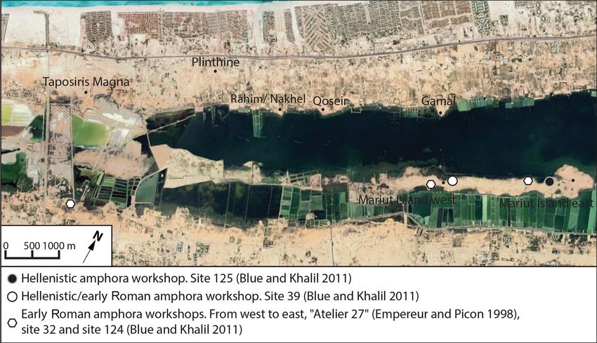
40                                        M. Crépy and M.-F. Boussac: Western Mareotis lake(s) during the Late Holocene

                         zwar auf Analyse von Berichten früher Gelehrter (1800–1945), Karten (1807–1958) und Satellitenfo-
                         tos (Corona). Sie ermöglicht es, die Ausdehnung des Sees/der Seen zu verschiedenen Zeiten im Wadi
                         Mariut zu rekonstruieren. Während des ersten Jt. v. Chr. erlebte die Lagune in ihrem westlichen Teil
                         eine Absenkung, gefolgt von Bauarbeiten in neu entstandenen Gebieten während der hellenistischen
                         Periode (332–30 v. Chr.). Durch das Graben mehrerer Kanäle im 2. Jh. n. Chr., um die Siedlungen mit
                         dem östlichen Teil des Mariut-Beckens zu verbinden, wurden der See bzw. die Seen neu gestaltet.

1    Introduction and objectives                                  2     General settings and previous studies

Lake Mariut, ancient Mareotis (Fig. 1), is a lagoon that          2.1    Geomorphic settings
polarised the human occupation of Egypt’s north-western
                                                                  Lake Mariut lies at the interface between three geomorpho-
margins during antiquity. The region developed mainly af-
                                                                  logical systems: the Mediterranean littoral, the Nile Delta
ter the foundation of Alexandria in 332 BCE (Fraser, 1972),
                                                                  and the Libyan desert. During the Holocene, distinct mor-
although earlier occupation is archaeologically evidenced
                                                                  phogenetic processes have influenced its evolution: climate
since the New Kingdom at Plinthine (Boussac et al., 2015;
                                                                  change and the evolution of the Nile floods (Macklin et al.,
Boussac and Redon, 2021) and Kom Bahig (Empereur,
                                                                  2015), sea level rise (Dalongeville and Fouache, 2005), wind
2018). Agricultural lands and towns, such as Taposiris on
                                                                  erosion (Woronko, 2012; Crépy, 2021), subsidence (Penning-
the north shore (Boussac, 2015) and Marea (Pichot, 2012)
                                                                  ton et al., 2017), and neotectonics (Stanley, 2003), to which
on the southern one, flourished until the Arab-Muslim con-
                                                                  must be added the impact of human activities (Flaux et al.,
quest, which was followed in the 7–8th centuries CE by a re-
                                                                  2012).
configuration of the territory and the abandonment of many
                                                                     The lagoon, whose water level is currently controlled by
settlements (Décobert, 2002). During all periods, the human
                                                                  means of pumps and a canal to the Mediterranean Sea located
occupation of the region has been closely linked to the lake
                                                                  at Al Max (in the vicinity of Alexandria), occupies parts of
(Blue and Khalil, 2011).
                                                                  a depression, some areas of which are below mean sea level.
   Strabo (∼ 60 BCE–∼ 20 CE) mentions a very large lake
                                                                  This depression consists of two distinct areas (Fig. 1). To the
(Strabo, 2015:17, 14) of major economic importance (Strabo,
                                                                  east, its edges slope gently, and no significant topographical
2015:17, 7). Later, accounts by travellers from the 6th cen-
                                                                  features separate it from the now-drained Abukir lagoon to
tury CE to 1798 (Sennoune, 2015), maps (Awad, 2010) and
                                                                  the north-east, the delta to the east, the desert to the west
sedimentological data (Flaux, 2011) indicate significant fluc-
                                                                  and the agricultural lands of Al Buhayrah to the south. In
tuations of the lake levels and positions (including phases of
                                                                  the western part, often called wadi Mariut or Mariut valley,
desiccation). At the beginning of the French expedition to
                                                                  the depression stretches from east to west and is bordered by
Egypt (1798–1801), the lake area was dry (Le Père, 1825).
                                                                  two steeply sloping calcarenite ridges separating it from the
   If one focuses on the wadi Mariut (western part of the Mar-
                                                                  Mediterranean Sea in the north and from another depression
iut basin; Fig. 1), the presence at some Hellenistic and/or
                                                                  in the south.
Roman sites of harbour structures close to remains that are
incompatible with the vicinity of a lake (e.g. amphora work-
shops) and dating back to the same periods constitutes a          2.2    Archaeological and historic settings
geoarchaeological paradox. How can this paradox be solved?               (∼ 1000 BCE–∼ 1000 CE)
Did the lake levels shift at high frequency during this period?   The archaeology of the western part of Lake Mareotis (wadi
Have several independent lakes of small extent coexisted in       Mariut) has been investigated since the beginning of the 20th
the Mariut basin? Should a major water engineering work be        century (e.g. De Cosson, 1935). From the beginning of the
considered?                                                       1st millennium BCE to the end of the 1st millennium CE, the
   This geoarchaeological study, undertaken within the            following dynamics of occupation have been demonstrated:
French mission at Taposiris Magna and Plinthine (dir. M.-F.       from the New Kingdom (∼ 1580–∼ 1077 BCE), occupation
Boussac and then B. Redon), aims to assess, through a com-        on high points on the northern and southern banks of the
posite method, the western extension of the Mareotis lake(s)      valley (Boussac et al., 2015; Empereur, 2018; Nenna et al.,
in wadi Mariut from the 4th century BCE to the 8th century        2020); from the Saite Period (664–525 BCE) at the latest,
CE.                                                               agricultural development (wine) attested to in Plinthine on
                                                                  the northern bank (Redon et al., 2017); during the Hellenis-
                                                                  tic period (332–30 BCE), urban development in sectors lo-
                                                                  cated lower down on both banks and on Mariut island (Blue
                                                                  and Khalil, 2011; Boussac, 2015); and from the early Roman

E&G Quaternary Sci. J., 70, 39–52, 2021                                             https://doi.org/10.5194/egqsj-70-39-2021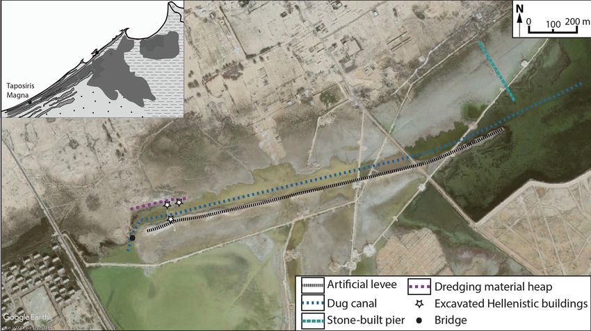
M. Crépy and M.-F. Boussac: Western Mareotis lake(s) during the Late Holocene                                                     41

Figure 1. Main geomorphic units in the Mariut area, based on Flaux (2011).

period (30 BCE–284 CE) to the Arab-Islamic conquest (mid-             latter being determined by climatic conditions and human ac-
7th century CE), increasing harbour and economic devel-               tivities in its watershed.
opment (including wine export) (Décobert, 2002; Blue and                 During the Holocene, the evolution of the Mariut region
Khalil, 2011; Boussac and El-Amouri, 2010; Dzierzbicka,               (Table 1) has been established by the work of Clément Flaux
2018; Pichot and Simony, 2021). The Hellenistic and Roman             mainly thanks to data from the eastern part of the Mariut
periods are characterised by structures occupying areas that          but also from Taposiris and from the southern bank of the
are very close to the current shores of the lake (or even in          wadi Mariut (Flaux et al., 2011; Flaux, 2011, 2012). From
the present lake) and located at altitudes much lower than the        the early Roman period (30 BCE–284 CE), the evolution of
remains of other periods, suggesting that the lake levels were        the lagoon has been linked to the filling in of the Canopic
lower during these periods or that the geometry of the lake           branch (Fig. 1; Bernand, 1970; Hairy and Sennoune, 2009)
was different. This has been demonstrated at Taposiris and            and to the sinking of its deltaic lobe below sea level around
on Mariut island (Blue and Khalil, 2011; Flaux, 2012).                the 8th century CE (Stanley et al., 2001).

2.3     Previous geomorphological and geoarchaeological
                                                                      2.3.2   A geoarchaeological paradox
        studies
                                                                      This general environmental pattern cannot be directly applied
2.3.1    Holocene history of the Mariut lagoon
                                                                      to the wadi Mariut; on the one hand, subsidence is strong
The calcarenite ridge separating the Mariut depression and            in the eastern part of the Mariut depression but very weak
the Mediterranean Sea, as well as the ridge delimiting the            in wadi Mariut (Pennington et al., 2017), and on the other
wadi Mariut to the south, predate the Holocene (El Asmar              hand, marine and Nilotic water inputs both originate from the
and Wood, 2000) and have durably limited the extension of             east (Fig. 1). Moreover, in wadi Mariut, Pleistocene outcrops
the lagoon. The Holocene shifts of the lagoon were therefore          are not uncommon and the Pleistocene–Holocene boundary
mainly conditioned by the balance between sea level varia-            is generally close to the topographic surface, so less sedimen-
tions, subsidence, and the Nile’s liquid and solid inputs, the        tation occurred during the Holocene (Flaux, 2012).

https://doi.org/10.5194/egqsj-70-39-2021                                               E&G Quaternary Sci. J., 70, 39–52, 2021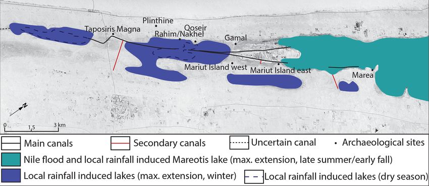
42                                          M. Crépy and M.-F. Boussac: Western Mareotis lake(s) during the Late Holocene

Table 1. Holocene evolution of the Mariut region based on Flaux et al. (2011) and Flaux (2011, 2012).

              Period                      Status                                     Main causes
              ∼ 9000–∼ 7000 BCE           Coastal deltaic plain periodically         Nile Delta progradation
                                          flooded by the Nile
              ∼ 6000–∼ 5500 BCE           Lagoon sedimentation                       Holocene marine transgression
              ∼ 5500–∼ 2800 BCE           Lagoon closed to marine influences         Nile Delta progradation
              ∼ 2800–∼ 1200 BCE           Marine influence and hydrological in-      Climatic aridification and reduced Nile
                                          stability                                  flow
              ∼ 1000 BCE–∼ 200 CE         Lagoon more subject to the Nilotic in-     Canopic branch defluviation and
                                          fluence than to the maritime one and an-   anthropogenic activities
                                          thropogenic disturbances
              ∼ 200–∼ 800 CE              Brackish lagoon dominated by nilotic       To be determined
                                          inputs
              ∼ 800–∼ 1200 CE             Sebkha                                     Nile defluviation and canal siltation

   Sedimentological and physico-chemical analyses have                  dredging material. A bridge that connects the bank to the
been interpreted as evidence of a large extension of the Mar-           artificial levee is dated to early Roman times, more specif-
iut lagoon westward between ∼ 4000 BCE and ∼ 1200 CE                    ically to the 2nd century CE (Boussac and El Amouri, 2010).
even beyond the present limits of the lake (Warne and Stan-             The artificial levee and the dredged material cover Hellenis-
ley, 1993). A generally high water level in antiquity has also          tic remains (2nd–1st century BCE), part of which is below
been assumed for Taposiris (Tronchère, 2010; Tronchère et               the present water surface (Boussac and El-Amouri, 2010). To
al., 2014).                                                             the east, a stone pier from the late Roman period (4th century
   A lot of ancient harbour infrastructure has been prospected          CE) closes the port complex. The swamp located to the north,
(Blue and Khalil, 2011) but also Hellenistic and Roman re-              which could suggest a harbour basin, was already a swamp
mains submerged or located close to the current shores of the           during antiquity (Flaux, 2012).
lagoon, including amphora workshops (Empereur and Picon,                   The chronological sequence is as follows (Boussac and El-
1998; Flaux, 2012). Their underground kilns make them in-               Amouri, 2010; Boussac, 2015):
compatible with their proximity to the lake and high water
levels. However, the operation of the few ports and sites bor-              – urban development during the 2nd–1st century BCE;
dering the lake studied in more detail implies relatively high
water levels, for the Roman period at least, for example at                 – building of an artificial levee during the 2nd century CE;
Taposiris (Boussac and El Amouri, 2010) or on Mariut is-
land (Flaux, 2012).                                                         – raising of the artificial levee after the 4th century CE;
   The archaeological remains and the environmental data
from wadi Mariut thus present a geoarchaeological paradox                   – installation of the eastern pier around the 4th century
to be solved. Not only do the environmental and archaeolog-                   CE;
ical data not converge, but even the archaeological data seem
to contradict each other unless we consider a variability in
                                                                            – abandonment of the area after the 7th century CE.
water levels of high frequency, several independent lakes or
water engineering on the scale of the wadi Mariut, whose re-
mains have not yet been highlighted.                                    3      Material and methods

                                                                        Carrying out a geoarchaeological study in wadi Mariut is
2.3.3   Illustration of the geoarchaeological paradox:
                                                                        complex due to the lack of analysis equipment and to Egyp-
        Taposiris harbour
                                                                        tian legislation prohibiting the export of samples. Moreover,
The lake complex of Taposiris (Fig. 2), investigated since              urbanisation and agricultural development in the region in
1998 by the French mission at Taposiris Magna and                       the 20th century has considerably altered the topography and
Plinthine, consists of a dug or deepened canal bordered to              sedimentary formations of the region (quarries, salt ponds,
the south by an artificial sedimentary levee on which ware-             etc.). We therefore used a combination of methods to over-
houses are lined up and to the north, at its eastern end, by            come these obstacles.

E&G Quaternary Sci. J., 70, 39–52, 2021                                                    https://doi.org/10.5194/egqsj-70-39-2021
M. Crépy and M.-F. Boussac: Western Mareotis lake(s) during the Late Holocene                                                  43

Figure 2. Harbour of Taposiris. Base map image: © Google Earth Pro November 2009.

3.1   Reassessment of geoarchaeological data                       3.4     Corona photographs
We reassessed and crossed three types of data that led re-         Three declassified satellite photographs from the Corona pro-
searchers to reconstruct a large extension of Lake Mareotis        gramme (Table 3) were acquired free of charge on Earth-
in wadi Mariut:                                                    Explorer (https://earthexplorer.usgs.gov/, last access: 22 Jan-
                                                                   uary 2021).
  – sedimentological, biological and physico-chemical data            They allow us to evaluate the topography of the now-
    (available in Tronchère, 2010; Tronchère et al., 2014;         flooded areas and to observe the region before its current
    Warne and Stanley, 1993);                                      development. Moreover, they help us to escape the subjec-
                                                                   tivity of early scholars and the bias of cartographic surveys
  – archaeological data, in particular the distribution of sites   in swampy areas and to observe the terrain from the sky to
    (from Blue and Khalil, 2011 and Boussac, 2015);                identify macrostructures.

  – historical data, through an analysis of two sources fre-
    quently used in the study of the region (Strabo, 2015:17;      4     Results and interpretation
    Jacotin, 1818).
                                                                   4.1     Reassessment of geoarchaeological data
                                                                   4.1.1    Sedimentological data: playa, lake or lakes?
3.2   Early scholars’ accounts (1800–1945)
                                                                   Two studies led to the reconstruction of a large extension of
A total of 11 early western scholars’ contributions (Chabrol       Lake Mareotis in its western part: Warne and Stanley (1993)
and Lancret, 1829; De Cosson, 1935; El Falaki, 1872; Le            at the regional scale and Tronchère (2010) and Tronchère et
Père, 1823, 1825, 1829; Jacotin, 1824; Oliver, 1945; Reclus,       al. (2014) around Taposiris. The first study (Warne and Stan-
1885; Rennell, 1800; St John, 1849) have been selected and         ley, 1993) was based on the analysis of sedimentary cores
studied to recover data erased over time. They describe a pe-      and revealed the presence of a lagoon dominated by fluvial
riod during which human activities were less developed than        inputs throughout wadi Mariut and up to Taposiris in the
today and provide additional elements on archaeology, com-         west ∼ 2500–∼ 2000 years ago. If only the regional scale
pleting the data concerning the distribution of the sites and      and major trends are considered, these conclusions are cor-
the topography.                                                    rect, although a reassessment is needed at the local scale and
                                                                   is made possible by the rigour of Warne and Stanley (1993)
                                                                   in presenting their data. At the scale of wadi Mariut, the data
3.3   Maps (1807–1958)
                                                                   highlight three points:
Eight maps (Table 2) have been analysed to identify the to-
pography of the lands currently flooded and the vanished ar-           – on several isopleth maps (Fig. 3), the Nilotic influence
chaeological sites and to characterise the recent evolution of           does not appear (verdine/glauconite) or appears very
the extension of the lake.                                               slightly (mica, heavy minerals) in the western part of

https://doi.org/10.5194/egqsj-70-39-2021                                             E&G Quaternary Sci. J., 70, 39–52, 2021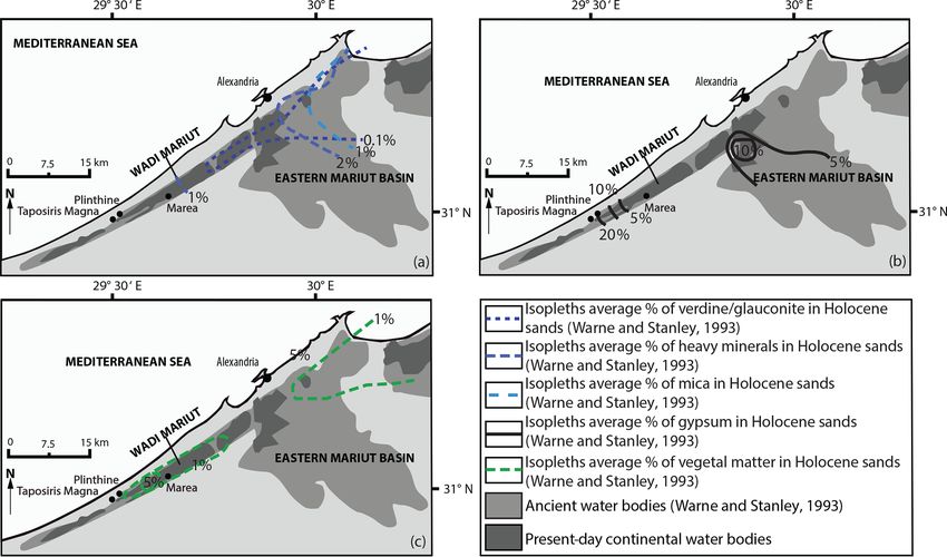
44                                            M. Crépy and M.-F. Boussac: Western Mareotis lake(s) during the Late Holocene

       wadi Mariut, and other parameters strongly differenti-          by the English to flood Lake Mareotis (19 Germinal An 9–
       ate it (gypsum, foraminifera);                                  19 April 1801)”. The lake on the map corresponds to a state
                                                                       when it was directly connected to the Aboukir lagoon, itself
  – the Holocene sedimentary column represents less than               open to the sea, and therefore at a much higher level than
    2.5 m in most of wadi Mariut;                                      the maxima during most of the studied period (4th century
                                                                       BCE–8th century CE) when the Canopic deltaic lobe used to
  – in the western part of wadi Mariut, the only facies that           be an obstacle to links with the Mediterranean Sea (Stanley
    can be linked to a lagoon are “lagoon margin mud” fa-              et al., 2001).
    cies whose composition could just as well correspond to
    playa or semi-playa deposits (as described by Embabi,
    2004, and by Crépy, 2016).                                         4.1.3    Archaeological data
                                                                       The spatio-temporal distribution of the sites could seem rel-
   The continuity of the lagoon up to Taposiris is therefore           evant to draw the ancient shores of the lake. However, two
not established by Warne and Stanley’s data (1993) which               obstacles prevent the proper exploitation of the survey results
show, in contrast, that at least one basin has undergone a spe-        (e.g. Blue and Khalil, 2011; Picon and Empereur, 1998). In
cific evolution (Fig. 3).                                              the absence of underwater surveys, the distribution of sites
   Data from Tronchère (2010) and Tronchère et al. (2014)              is incomplete and draws a shoreline corresponding to the
at local scale led to the reconstruction of a lake or lagoon           limit of the lake at the time of the survey (even if Blue and
reaching Taposiris during the whole Holocene (the alteration           Khalil, 2011, also mentioned some underwater remains, they
layer of the calcarenite substratum was dated to 40 254–               saw from the land), and surface surveys are not sufficient to
38 032 cal BCE1 ). However, the very small quantity of ostra-          give an exhaustive chronology of the sites. However, the fol-
cods found (some samples were totally free of them) and the            lowing observations can be made thanks to the Hellenistic
granulometric data do not go in this direction. The laser gran-        and Roman amphora workshops of Mariut island and Borg
ulometry curves are all multimodal, which Tronchère (2010)             el Arab (surveyed by Empereur and Picon, 1998, and Blue
attributed to a sampling bias. The presence of recurrent aeo-          and Khalil, 2011; Fig. 4). The altitude of their kilns shows
lian modes (loess: 10–20 µm; dune sand: 100–200 µm; ac-                that the lake must have been located within more restricted
cording to Tsoar and Pye, 1987) mixed with other modes                 limits or at a lower level than today in this part of wadi Mar-
would rather indicate a palustrine environment influenced by           iut. The kilns of this area are indeed located below the top of
desert dynamics (e.g. playa or sebkha margin). To sum up,              the phreatic water table induced by the current lake. Similar
the sedimentological data are more likely to correspond to             levels inferred for antiquity would thus hinder their use. Like-
marshy or immersed areas disconnected from the Mariut la-              wise, the Hellenistic quarter of the lower town of Taposiris
goon.                                                                  is incompatible with the present level of the lagoon (Flaux,
                                                                       2012)
4.1.2     Historical data: some necessary precautions
Strabo’s Book 17 (Strabo, 2015:17) and Jacotin’s map (1818)            4.2     Early scholars’ accounts (1800–1945)
are often used to study Lake Mareotis’ extension during an-
                                                                       4.2.1    Limits of the lake(s)
tiquity. According to the ancient geographer, the lake mea-
sured, in his time, 150 stadia (∼ 27.75 km) or more in width           Before the flooding in 1801, low areas of the Mariut depres-
and less than 300 stadia (∼ 55.5 km) in length (Strabo,                sion could fill with water after rainfall (Chabrol and Lancret,
2015:17, 14). These measurements have generally been in-               1829; Le Père, 1825) and form small independent lakes, for
terpreted in light of the current state of the lake, and the ori-      example southwest of Taposiris (St John, 1849). At the peak
entation has often been used as follows: 300 stadia from the           of the flood, the western limit of the water would have been
north-east to south-west and 150 stadia from the north-west            located at the level of the so-called Arabs’ tower (Jacotin,
to south-east. However, there is no indication of this orienta-        1824) or 1000 m east of Taposiris (Le Père, 1829) or about
tion in Strabo’s text, and data on the Holocene evolution of           500 m east of the Arabs’ tower (Fig. 5). W. G. Browne, at
the Nile Delta and on subsidence in the eastern Mariut basin           the end of the 18th century, saw no reason to consider a lake
would rather fit with an opposite orientation, especially if one       that would have been more than 1 or 1.5 leagues (∼ 4.83 or
takes into account a Nilotic influence.                                ∼ 7.25 km) from Alexandria in the past based on the obser-
   Jacotin’s map (1818) has sometimes been used as a ref-              vation of the ground and the topography (Rennell, 1800).
erence state of ancient Mariut (e.g. Tronchère et al., 2014)
even if the limits of the lake have been drawn after a British         4.2.2    Data on archaeological remains
military operation, as mentioned on the map, “Cuts made
                                                                       Early scholars mention remains that have now disappeared,
     1 Calibration by M. Crépy with OxCal using IntCal20 calibration   such as walls and canals in wadi Mariut (Chabrol and Lan-
curve based on raw data from Tronchère et al. (2014).                  cret, 1829), as well as levees or small dikes (now under wa-

E&G Quaternary Sci. J., 70, 39–52, 2021                                                   https://doi.org/10.5194/egqsj-70-39-2021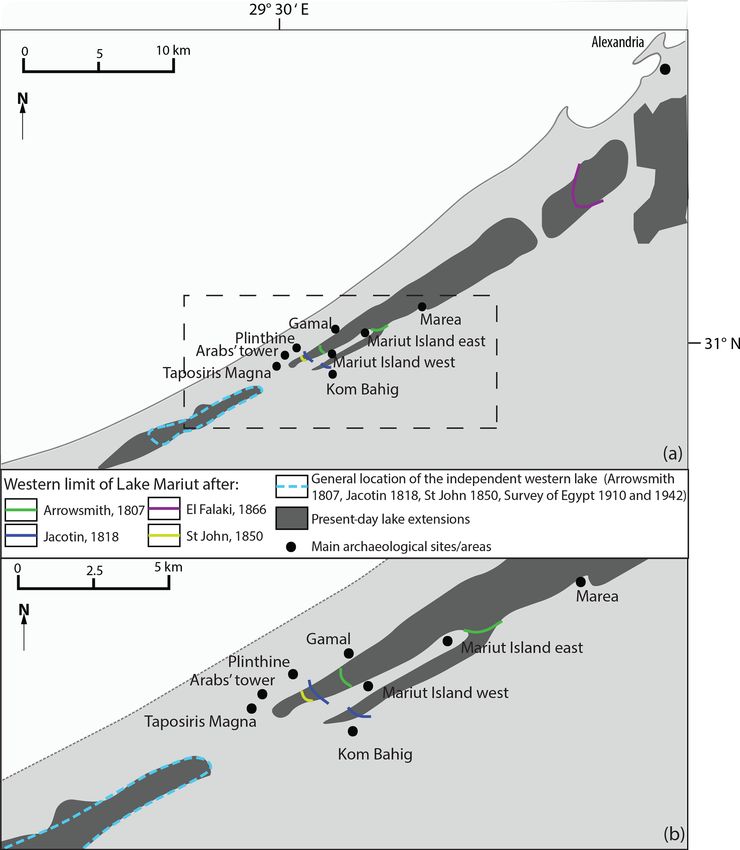
M. Crépy and M.-F. Boussac: Western Mareotis lake(s) during the Late Holocene                                                            45

Table 2. Maps used in this study.

                       Date         Author           Link
                       1807         Arrowsmith       https://gallica.bnf.fr/ark:/12148/btv1b530669569/
                                                     (last access: 22 January 2021)
                       1818         Jacotin          https://gallica.bnf.fr/ark:/12148/btv1b531569998/
                                                     (last access: 22 January 2021)
                       1827         Coste            https://gallica.bnf.fr/ark:/12148/btv1b8491814n/
                                                     (last access: 22 January 2021)
                       1850         St John          https://gallica.bnf.fr/ark:/12148/btv1b53136219p/
                                                     (last access: 22 January 2021)
                       1866         El Falaki        https://gallica.bnf.fr/ark:/12148/btv1b10101071m/
                                                     (last access: 22 January 2021)
                       1910         Survey of        https://www.davidrumsey.com/luna/servlet/detail/
                                    Egypt            RUMSEY~8~1~317305~90086593:Sheet-47-Bahig
                                                     (last access: 22 January 2021)
                       1942         AMS              http://legacy.lib.utexas.edu/maps/ams/egypt/
                                                     txu-pclmaps-oclc-6559596-el-hammam.jpg
                                                     (last access: 22 January 2021)
                       1958         AMS              http://legacy.lib.utexas.edu/maps/ams/north_africa/
                                                     txu-oclc-6949452-nh35-8.jpg (last access: 22 January 2021)

Figure 3. (a) Isopleths (based on Warne and Stanley, 1993) recording the Nile’s influence on the Mariut basin. (b) Isopleths (based on Warne
and Stanley, 1993) indicating high evaporation processes during the Holocene in the western part of wadi Mariut. (c) Isopleths (based on
Warne and Stanley, 1993) emphasising specific local dynamics in wadi Mariut.

https://doi.org/10.5194/egqsj-70-39-2021                                                   E&G Quaternary Sci. J., 70, 39–52, 2021
46 M. Crépy and M.-F. Boussac: Western Mareotis lake(s) during the Late Holocene Figure 4. Amphora workshops in the area (base map image: © Google Earth Pro). Figure 5. Limit of the lakes according to old maps. (a) Regional scale. (b) More local scale. E&G Quaternary Sci. J., 70, 39–52, 2021 https://doi.org/10.5194/egqsj-70-39-2021
M. Crépy and M.-F. Boussac: Western Mareotis lake(s) during the Late Holocene                                                      47

Table 3. Corona photographs used in this study.                      are below mean sea level and are separated by topographic
                                                                     thresholds and higher areas.
          Corona ID              Acquisition (mm/yyyy)
          DS1016-2088DF007       01/1965                             4.3.3    Mention of ruins and remains
          DS1109-2171DF010       03/1970
          DS1111-2167DA024       08/1970                             The ruins are numerous on both banks of wadi Mariut, as
                                                                     well as on islands and even in the marshy part at its bottom
                                                                     (El Falaki, 1866). To the south of Taposiris and near Kom
                                                                     Bahig, a map (St John, 1850) shows the remains of cata-
ter) which were spanned by small bridges and crossed the             combs and an excavation on the opposite bank. Many dikes,
wadi Mariut (Le Père, 1823). El Falaki (1872) even men-              causeways or bridges are also indicated (Jacotin, 1818); there
tions entire sites (destroyed by modern construction) extend-        is one causeway between Marea and Sidi Kirayr and a sec-
ing over 9 km north-east of Taposiris, thus offering a counter-      ond between Gamal and Mariut island, and elements of dikes
part on the north bank to the succession of sites still visible on   or causeways are represented at Taposiris. Finally, the dug
the south bank (Blue and Khalil, 2011; Pichot and Simony,            canal of the port of Taposiris appears clearly on two maps; El
2021). Because of the presence of underwater remains, some           Falaki (1866) indicates in addition to this canal, which he ex-
early scholars speculated that the lake was completely or par-       tends to the west, a second canal towards the south in accor-
tially desiccated during part of antiquity without specifying        dance with the descriptions of Oliver (1945; cf. Sect. 4.2.3),
a precise period (e.g. Reclus, 1885).                                and Arrowsmith (1807) roughly draws the shape of the west–
                                                                     east canal and designates it as “Remains of an ancient canal
4.2.3    Data on Taposiris artificial levee                          from the Nile”. Unfortunately, travellers’ descriptions do not
                                                                     make it possible to assess precisely the dating of the remains,
Some early scholars described the harbour complex of                 but the low occupation of the area from the end of the 7th
Taposiris, bringing two pieces of information that have now          century CE (Décobert, 2002) until at least the end of the 18th
been erased. The west–east artificial levee of Taposiris was         century (Hairy and Sennoune, 2009) makes an ancient dat-
doubled by an ancient causeway (De Cosson, 1935), and a              ing very likely. Moreover, concerning the canals, neither the
second canal dug across the wadi Mariut from north to south          books of Coste (1878) and Linant de Bellefonds (1873), who
linked Taposiris harbour to a dock on the south side of the          worked on agricultural projects in the region, nor the topo-
valley and was doubled with a causeway located on the sed-           graphical maps of the 20th century mention the canals, which
imentary levee forming the west bank of the canal (Oliver,           confirms that they were not made in the 19th or 20th cen-
1945).                                                               turies.

4.3     Maps (1807–1958)
                                                                     4.4     Corona photographs: canals in wadi Mariut
4.3.1    Extension of the lake(s)
                                                                     In the photographs used, the levels and extent of the lake are
For all but one (St John, 1850) of the studied maps, the lake        lower than they are today as the agricultural projects that now
did not reach the Arabs’ tower even in the periods follow-           bring in large amounts of surplus irrigation water were still
ing the flood of 1801 (Fig. 5). Wadi Mariut is often depicted        in their initial stages. In the photograph of August 1970 in
as being occupied exclusively by marshes (El Falaki, 1866;           particular, the level is very low because of summer evapora-
on a smaller area, Survey of Egypt, 1910, 1942) or being             tion and scarce rainfall, whereas it is higher in the two other
completely dry (AMS, 1958). The boundaries of the lake,              ones (March 1970 and January 1965). In the photographs, it
whether dried up (Coste, 1827) or in water (Arrowsmith,              appears that in the western part of wadi Mariut, several of
1807; Jacotin, 1818), extend farther to the east-south-east          the closed basins are linked by two large canals or channels
in its eastern part than to the west in wadi Mariut, which is        (the longest being more than 12 km) joined to the west of
in favour of a reinterpretation of the measurements given by         Gamal. From there, a unique canal extends discontinuously
Strabo (cf. Sect. 4.1.2). Finally, a small independent lake or       up to the artificial levee of Taposiris and further south-west
marsh is drawn to the west of Taposiris (Fig. 5) in five out         and then west from the Roman bridge of Taposiris where
of six maps covering this sector (Arrowsmith, 1807; Jacotin,         it ends in the small lake mentioned in maps and accounts
1818; St John, 1850; Survey of Egypt, 1910, 1942).                   (Fig. 6). The maximal width of the two joint canals is around
                                                                     80 m. They border some depressions which could have been
                                                                     harbour basins as they are located close to sites including an-
4.3.2    Subaquatic topography
                                                                     cient piers (Fig. 6). The north–south canal (reported by El
One map (AMS, 1958) gives an insight into the now-flooded            Falaki, 1866; Oliver, 1945) is also visible.
topography of the bottom of wadi Mariut; the western part of            Some shorter, narrow canals branch to the two main ones
wadi Mariut includes several closed basins whose elevations          and join sites to the south. It is difficult to determine whether

https://doi.org/10.5194/egqsj-70-39-2021                                               E&G Quaternary Sci. J., 70, 39–52, 2021
48 M. Crépy and M.-F. Boussac: Western Mareotis lake(s) during the Late Holocene
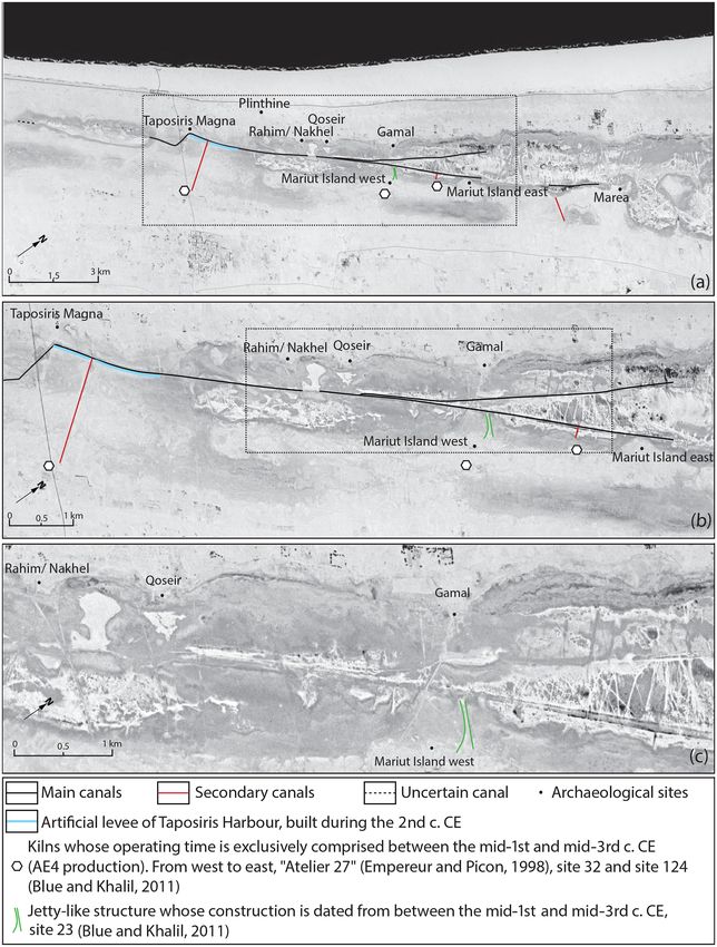
Figure 6. Corona photograph DS1111-2167DA024 (USGS). (a) Canal from Marea to the west of Taposiris. (b) Focus on the central area.
(c) Details of the canals.
these canals were deepened channels in flooded areas or if iut lake but several lakes occupying closed depressions (cf.
they were canals dug in dry or marshy areas. However, the Sects. 4.1, 4.2, 4.3.2, 4.4) which could be filled by rain-
shapes of the banks of rubble along some parts of the two fall. The creation of canals (cf. Sect. 4.4) made it possible
main canals indicate digging in an environment dry enough to connect them by crossing the topographic thresholds (cf.
for the rubble to remain despite the high proportions of silt Sect. 4.3.2). In this way, it was possible to have harbour in-
and clay at the bottom of wadi Mariut. frastructures without a continuous stretch of water. These
canals are connected to the Taposiris harbour canal, whose
digging is firmly dated to the 2nd century CE, and they bor-
5 Discussion
der several sites that were occupied during the same period,
5.1 Solving the paradox: lakes and canals including three amphora kilns whose construction is dated
between the mid-1st and the mid-3rd centuries CE (Fig. 6).
The combination of all these elements shows that for cer- It is therefore probable that the canals were built during the
tain periods of the Holocene, there was not a unique Mar-
E&G Quaternary Sci. J., 70, 39–52, 2021 https://doi.org/10.5194/egqsj-70-39-2021M. Crépy and M.-F. Boussac: Western Mareotis lake(s) during the Late Holocene 49
Figure 7. Corona photograph DS1111-2167DA024 (USGS). Proposed extension of the lakes in wadi Mariut during the Hellenistic and early
Roman period. Coloured patches correspond to maximum extensions.
Roman period as a harbour complex including several sites and the maps at the bottom of the wadi Mariut, which are
(including Taposiris, Mariut island, Marea, etc.). Under these located in some of the topographic threshold areas separat-
conditions, it becomes easier to understand how Roman har- ing the closed depressions. However, flooding during intense
bours could have been in the direct vicinity of Roman am- rainfall or an exceptional Nile flood cannot be excluded.
phora kilns; it was not an extensive lake with a highly devel- During the Roman period, the digging of the canal artifi-
oped underground water table but smaller basins connected cially re-established the connectivity between the lakes of the
to each other by canals. This interpretation pattern is fully wadi Mariut and linked all the sites to Lake Mareotis proper
consistent with previously published sedimentological data in the east and thus to Alexandria, the Nile and the Mediter-
(e.g. Warne and Stanley, 1993; Tronchère, 2010; Tronchère ranean, contributing to the economic growth of the region.
et al., 2014; Flaux, 2012). Obviously, the chronology will Finally, the construction of the stone jetty at Taposiris after
have to be refined by fieldwork at the scale of the wadi Mar- the 4th century CE, which includes a fish pond, as well as
iut. The magnitude of the works raises a question: for what the raising of the levee after the 4th century CE (Boussac
reasons were canals and at least one bridge built? This article and El Amouri, 2010), seems to indicate a rise in the water
alone cannot provide a complete answer, but it is likely that level which could be linked to the gradual subsidence of the
in an Egyptian climatic context dominated by hyper aridity, Canopic branch (Stanley et al., 2001) or greater Nile floods.
the agricultural opportunities offered by the Mediterranean This rise has also been demonstrated near Marea (Pichot and
winter rainfall and the natural concentration of surface wa- Flaux, 2015). Our study does not allow us to know more, but
ter in wadi Mariut justified the efforts in connection with the that of Flaux (2011) indicates a severe drying up as early as
export of local agricultural productions (e.g. wine). the 9th century CE.
5.2 New hypothesis on Mareotis lake(s) evolution
6 Conclusion and perspectives
During the first part of the period under study (first half of
the 1st millennium BCE), the archaeological remains were This article returns to a subject already addressed by classi-
mainly found in high areas, which could lead to the assump- cal sedimentological methods of geoarchaeology. This type
tion of high lake levels compatible with the palaeoenviron- of data alone, although obviously necessary to study past
mental data (from Flaux, 2012), but the lack of archaeolog- environments, was not sufficient to solve the paradox of
ical excavations calls for caution. In contrast, it is clear that the wadi Mariut. Combining it with geohistorical sources
during the Hellenistic and early Roman periods, the water (Corona photographs, maps, accounts of early scholars) al-
levels were lower, and the extension of the water was smaller lows for new interpretations. They provide a complementary
(Fig. 7) thanks to the presence of numerous sites incompati- vision of the spatial organisation, landscapes and environ-
ble with a single large lake. This reduction can be explained mental dynamics prior to the profound changes in this region
both by the progradation of the Canopic lobe closing off the since the 1980s.
Bay of Aboukir and the connection to the sea (Flaux, 2012) They allow for the development of a model of the evolu-
and by the canal of Alexandria, depriving the lake of part of tion of the wadi Mariut from the beginning of the Hellenistic
the Nile flood to the benefit of the city’s water supply. The ur- period (late 4th century BCE) to the beginning of the Me-
ban and agricultural development of this period could there- dieval period (8th century CE). The lake first experienced a
fore partly explain the ruins mentioned by the early scholars period of drying up followed by urban and agricultural devel-
https://doi.org/10.5194/egqsj-70-39-2021 E&G Quaternary Sci. J., 70, 39–52, 202150 M. Crépy and M.-F. Boussac: Western Mareotis lake(s) during the Late Holocene
opment, including in some sectors of the bottom of the wadi early scholars’ accounts. MC took charge of the writing of the pa-
Mariut. During the Roman period in the 2nd century CE, a per, MFB amended and approved it.
system composed of large canals was set up, linking inde-
pendent basins to each other and to the large Lake Mareotis
(the lake actually described by Strabo) in the east. After the Competing interests. The authors declare that they have no con-
4th century CE, higher water levels are likely, before drying flict of interest.
up in the 9th century CE (Flaux, 2012). Refining and com-
pleting this chronology and this model, as well as studying
the canals in detail (possible locks, variability of water lev- Special issue statement. This article is part of the special issue
“Geoarchaeology of the Nile Delta”. It is a result of the workshop
els, etc.) now requires us to go back to the field and start new
“Geoarchaeology of the Nile Delta: Current Research and Future
coring and excavations. It is also a starting point for a new Prospects”, Würzburg, Germany, 29–30 November 2019.
analysis of regional economy and history.
Acknowledgements. This study has been done as part of the
Data availability. The reassessed sedimentological datasets French mission at Taposiris Magna and Plinthine with the kind
are available in the articles cited in the paper. All the authorisation of the Egyptian Ministry of Antiquities. We thank
maps are available free of charge on online platforms Bérangère Redon and Ninon Blond for their suggestions. We thank
(last access: 22 January 2021): http://legacy.lib.utexas.edu/ the anonymous referee and Judith Bunbury for their reviewing
maps/ams/egypt/txu-pclmaps-oclc-6559596-el-hammam.jpg works. We warmly thank the editors of this special issue and the
(AMS, 1942), http://legacy.lib.utexas.edu/maps/ams/north_ organisers of the workshop “Geoarchaeology of the Nile Delta: Cur-
africa/txu-oclc-6949452-nh35-8.jpg (AMS, 1958), https: rent Research and Future Prospects”.
//gallica.bnf.fr/ark:/12148/btv1b530669569/ (Arrowsmith 1807),
https://gallica.bnf.fr/ark:/12148/btv1b8491814n/ (Coste, 1827),
https://gallica.bnf.fr/ark:/12148/btv1b10101071m (El Falaki,
Financial support. This research was funded by the French In-
1866), https://gallica.bnf.fr/ark:/12148/btv1b531569998/f42.item
stitute of Oriental Archaeology (IFAO), HiSoMA (MOM) and the
(Jacotin, 1818), https://gallica.bnf.fr/ark:/12148/btv1b53136219p/
French Ministry of Foreign Affairs. The open-access publication
(St John, 1850), https://www.davidrumsey.com/luna/servlet/
was partly funded by DEUQUA and partly by the Shelby White
detail/RUMSEY~8~1~317305~90086593:Sheet-47-Bahig (Sur-
and Leon Levy Program for Archaeological Publications.
vey of Egypt 1910). These URLs are also indicated in the
References. Most of the traveller or early scholar accounts
used in this paper are available free of charge on online plat-
forms (last access: 22 January 2021): https://gallica.bnf.fr/ark: Review statement. This paper was edited by Julia Meister and
/12148/bpt6k28016p/f1.item.r=descriptiondel{’}egypte reviewed by Judith Bunbury and one anonymous referee.
(Chabrol and Lancret, 1829; Le Père, 1829), https:
//books.google.fr/books?id=yWo3AQAAMAAJ&printsec=
frontcover&hl=fr#v=onepage&q&f=false (Coste, 1878), https:
References
//gallica.bnf.fr/ark:/12148/bpt6k280140.r=descriptionel{’}egypte
(Jacotin, 1824), https://gallica.bnf.fr/ark:/12148/bpt6k2991761/
f9.item.r=dictionnaire%20des%20d%C3%A9couvertes% AMS: El Hammam 88/42, available at: http://legacy.lib.utexas.edu/
20mou%20-%20pat (Le Père, 1823), https://gallica.bnf.fr/ark: maps/ams/egypt/txu-pclmaps-oclc-6559596-el-hammam.jpg
/12148/bpt6k28013n.r=descriptiondel{’}egypte (Le Père, 1825), (last access: 22 January 2021), 1942.
https://books.google.de/books?id=tepYAAAAYAAJ&printsec= AMS: Burg El Arab, Serie P-502, available at: http://legacy.lib.
frontcover&hl=fr#v=onepage&q&f=false (Linant de Belle- utexas.edu/maps/ams/north_africa/txu-oclc-6949452-nh35-8.
fonds, 1873), https://archive.org/details/geographicalsys00renn/ jpg (last access: 22 January 2021), NH35-8, 1958.
page/n7/mode/2up (Rennell, 1800), https://archive.org/details/ Arrowsmith, A.: Map of Lower Egypt, available at: https://
adventuresinliby00stjo/page/n7/mode/2up (St John, 1849). These gallica.bnf.fr/ark:/12148/btv1b530669569/ (last access: 22 Jan-
URLs are also indicated in the References. Corona photographs are uary 2021), 1807.
available free of charge at https://earthexplorer.usgs.gov/ (USGS, Awad, I.: A Study of the Evolution of the Maryut Lake through
2021) using the following Corona ID (also provided in Table 3): Maps, in: Lake Mareotis Conference: Reconstructing the past,
DS1016-2088DF007, DS1109-2171DF010, DS1111-2167DA024. Universities of Southampton and Alexandria, Alexandria, Egypt,
2008, edited by: Blue, L. and Khalil, E., Archaeopress, Oxford,
UK, 11–33, 2010.
Bernand, A.: Le Delta égyptien d’après les textes grecs. 1 – les con-
Author contributions. MC carried out the reassessment of sedi-
fins libyques, IFAO, Le Caire, 1970 (in French).
mentological, archaeological and historical data, as well as the col-
Blue, L. K. and Khalil, E.: A multidisciplinary approach to Alexan-
lection and analysis of maps, early scholars’ accounts, and Corona
dria’s economic past: The Lake Mareotis research project, Ar-
photographs. MFB contributed to the reassessment of the archaeo-
chaeopress, Oxford, UK, 2011.
logical and historical data, as well as to the collection of maps and
Boussac, M.-F.: Recent works at Taposiris and Plinthine, Bulletin
de la Société archéologique d’Alexandrie, 49, 189–217, 2015.
E&G Quaternary Sci. J., 70, 39–52, 2021 https://doi.org/10.5194/egqsj-70-39-2021M. Crépy and M.-F. Boussac: Western Mareotis lake(s) during the Late Holocene 51 Boussac, M.-F. and El-Amouri, M.: The lake structures at Taposiris, Empereur, J.-Y.: New data concerning the foundation of Alexandria, in: Lake Mareotis Conference: Reconstructing the past, Univer- in: Hellenistic Alexandria, edited by: Zerefos, C. and Vardinoy- sities of Southampton and Alexandria, Alexandria, Egypt, 2008, annis, M., Archaeopress, Athens, Greece, 3–12, 2018. edited by: Blue, L. and Khalil, E., 87–105, Archaeopress, Ox- Empereur, J.-Y. and Picon, M.: Les ateliers d’amphores du lac Mari- ford, UK, 2010. out, Bulletin de Correspondance Hellénique, 33, 75–79, 1998 (in Boussac, M.-F. and Redon, B.: L’intégration des confins nord- French). ouest de l’Égypte du Nouvel Empire à l’époque ptolémaïque. Flaux, C.: Connexion de la région lagunaire d’Alexandrie À propos des découvertes archéologiques récentes à Plinthine au Nil depuis 2 000 ans: entre contrôle anthropique et Taposiris Magna (côte méditerranéenne, région du lac Mari- et forçage naturel, Méditerranée, 117, 73–79, out), in: Western borders and margins of Egypt from Antiquity https://doi.org/10.4000/mediterranee.5935, 2011 (in French). to the Middle Ages, edited by: Boussac, M.-F., Dhennin, S., Re- Flaux, C.: Paléo-environnements littoraux Holocène du lac Maryut, don, B., Somaglino, C., and Tallet, G., IFAO press, in press, 2021 nord-ouest du delta du Nil, Égypte, PhD thesis, Aix-Marseille, (in French). France, 2012 (in French). Boussac, M.-F., Dhennin, S., and Redon, B.: Plinthine et la Flaux, C., Morhange, C., Marriner, N., and Rouchy, J.-M.: Bilan Maréotide Pharaonique, BIFAO, 115, 15–35, 2015 (in French). hydrologique et biosédimentaire de la lagune du Maryût (delta Chabrol, G. and Lancret, M. A.: Notice topographique sur la par- du Nil, Egypte) entre 8 000 et 3 200 ans cal. B.P., Geomorpholo- tie de l’Egypte comprise entre Rahmanyeh et Alexandrie, et gie, 17, 261–278, https://doi.org/10.4000/geomorphologie.9474, sur les environs du lac Mareotis, available at: https://gallica.bnf. 2011. fr/ark:/12148/bpt6k28016p/f1.item.r=descriptiondel’egypte (last Fraser, P.M.: Ptolemaic Alexandria, Clarendon Press, Oxford, UK, access: 22 January 2021), in: Description de l’Égypte, C.L.F. 1972. Pancoucke, Paris, France, 18, 2, 3–28, 1829 (in French). Flaux, C., El-Assal, M., Marriner, N., Morhange, C., Rouchy, Coste, P.-X.: Carte de la Basse-Égypte dédiée à Mo- J.-M., Soulié-Märsche, I., and Torab, M.: Environmental hammed Aly Pacha, available at: https://gallica.bnf.fr/ark: changes in the Maryut lagoon (northwestern Nile delta) dur- /12148/btv1b8491814n/ (last access: 22 January 2021), vice ing the last ∼ 2000 years, J. Archaeol. Sci., 39, 3493–3504, Roi, 1827. https://doi.org/10.1016/j.jas.2012.06.010, 2012. Coste, P.-X.: Mémoires d’un artiste. Notes et Souvenirs de voyages Hairy, I. and Sennoune, O.: Le canal d’Alexandrie: la course au (1817–1877), available at: https://books.google.fr/books?id= Nil, in Du Nil à Alexandrie: Histoire d’eaux, edited by: Hairy, I., yWo3AQAAMAAJ&printsec=frontcover&hl=fr#v=onepage& Harpocrates Publishing, Alexandria, Egypt, 2009. q&f=false (last access: 22 January 2021), Marseille, Cayer et Jacotin, P.: Carte topographique de l’Égypte et de plusieurs par- Cie, Marseille, France, 1878 (in French). ties des pays limitrophes, available at: https://gallica.bnf.fr/ark: Crépy, M.: Géomorphologie et environnement du site de la nécrop- /12148/btv1b531569998/f42.item (last access: 22 January 2021), ole de Plinthine, in: La nécropole hellénistique de Plinthine, Dépôt général de la Guerre, Paris, France, 1818. IFAO press, Le Caire, in press, 2021 (in French). Jacotin, P.: Mémoire sur la construction de la carte de l’Egypte, Crépy, M.: Les Paysages du vent: géohistoire et géoarchéologie de available at: https://gallica.bnf.fr/ark:/12148/bpt6k280140.r= la dépression de Kharga (désert Libyque, Égypte) du cinquième descriptionel’egypte (last access: 22 January 2021), in: Descrip- siècle avant notre ère à nos jours, PhD thesis, Université Lumière tion de l’Egypte, 17, 437–652, C.L.F. Pancoucke, Paris, France, Lyon 2, France, Université de Lyon, 2 December 2016, available 1824 (in French). at: https://hal.archives-ouvertes.fr/tel-01490559/document (last Le Père, G.: Nome Maréotique, in: Dictionnaire des Découvertes, access: 23 March 2017), 2016 (in French). available at: https://gallica.bnf.fr/ark:/12148/bpt6k2991761/f9. Dalongeville, R. and Fouache, E.: Les variations de la ligne item.r=dictionnaire%20des%20d%C3%A9couvertes%20mou% de rivage en mer Méditerranée orientale du Pléistocène 20-%20pat (last access: 22 January 2021), 12, Louis Colas, supérieur et de l’Holocène récent: réflexions, Paleo, 31, 27–38, Paris, France, 214–222, 1823 (in French). https://doi.org/10.3406/paleo.2005.4781, 2005 (in French). Le Père, G.: Extrait d’un Mémoire sur les lacs et les déserts de De Cosson, A.: Mareotis, Country Life Ltd., London, UK, 1935. la Basse Egypte, available at: https://gallica.bnf.fr/ark:/12148/ Décobert, C.: Maréotide médiévale. Des Bédouins et des chrétiens, bpt6k28013n.r=descriptiondel’egypte (last access: 22 Jan- Alexandrie Médiévale, 2, 139–148, 2002 (in French). uary 2021), in: Description de l’Egypte, 16, 199–227, Panck- Dzierzbicka, D.: Oinos, Production and import of wine in Graeco- oucke, Paris, France, 1825 (in French). roman Egypt, JJP Suppl. 31, University of Warsaw, Warsaw, Le Père, G.: Mémoire sur la partie occidentale de la province Poland, 2018. de Bahyreh, connue anciennement sous le nom de El-Asmar, H. M. and Wood, P.: Quaternary shoreline development: nome maréotique, available at: https://gallica.bnf.fr/ark: the northwestern coast of Egypt, Quaternary Sci. Rev., 19, 1137– /12148/bpt6k28016p/f1.item.r=descriptiondel’egypte (last ac- 1149, https://doi.org/10.1016/S0277-3791(99)00097-9, 2000. cess: 22 January 2021), in: Description de l’Egypte, 18, 29–57, El-Falaki, M. B.: Carte des environs d’Alexandrie, available at: Panckoucke, Paris, France, 1829 (in French). https://gallica.bnf.fr/ark:/12148/btv1b10101071m (last access: Linant de Bellefonds, L. M. A.: Mémoires sur les princi- 22 January 2021), Erhard, Paris, France, 1866. paux travaux d’utilité publique exécutés en Egypte, avail- El-Falaki, M. B.: Mémoire sur l’antique Alexandrie, Bianco-Luno, able at: https://books.google.de/books?id=tepYAAAAYAAJ& F.-S. Mulhe, Copenhague, Denmark, 1872 (in French). printsec=frontcover&hl=fr#v=onepage&q&f=false (last access: Embabi, N. S.: The geomorphology of Egypt: landforms and evolu- 22 January 2021), Arthus Bertrand, Paris, France, 1873 (in tion, 1st Ed., Egyptian Geographical Society, Cairo, Egypt, 2004. French). https://doi.org/10.5194/egqsj-70-39-2021 E&G Quaternary Sci. J., 70, 39–52, 2021
52                                              M. Crépy and M.-F. Boussac: Western Mareotis lake(s) during the Late Holocene

Macklin, M. G., Toonen, W. H. J., Woodward, J. C., Williams,              Stanley, J.-D.: Nile delta margin: failed and fluidized deposits
   M. A. J., Flaux, C., Marriner, N., Nicoll, K., Verstraeten,               concentrated along distributary channels / La marge du delta
   G., Spencer, N., and Welsby, D.: A new model of river                     du Nil: concentration de dépôts fracturés et fluidisés le long
   dynamics, hydroclimatic change and human settlement                       des paléochenaux fluviatiles, Geomorphology, 9, 211–226,
   in the Nile Valley derived from meta-analysis of the                      https://doi.org/10.3406/morfo.2003.1186, 2003.
   Holocene fluvial archive, Quaternary Sci. Rev., 130, 109–              Stanley, J.-D., Goddio, F., and Schnepp, G.: Nile flood-
   123, https://doi.org/10.1016/j.quascirev.2015.09.024, 2015.               ing sank two ancient cities, Nature, 412, 293–294,
Nenna, M. D., Simony, A., Machinek, K., Soukiassian, G., Pi-                 https://doi.org/10.1038/35085628, 2001.
   chot, V., Awad, I., Séguier, R., Abdelaziz, M., Elsayed, M.,           St John, B.: Adventures in the Libyan Desert, available at: https:
   Hairy, I., and Soubias, P.: Alexandrie (actions du Centre d’études        //archive.org/details/adventuresinliby00stjo/page/n7/mode/2up
   alexandrines), Bulletin archéologique des Écoles françaises à             (last access: 22 January 2021), Putnam-John Murray, New
   l’étranger, Égypte, https://doi.org/10.4000/baefe.1094, 2020 (in          York-London, 1849.
   French).                                                               St John, B.: Map to Illustrate a Journey from Alexandria (Egypt)
Oliver, F. W.: Dust-Storms in Egypt and Their Relation to the                to The Oasis of Siwah, available at: https://gallica.bnf.fr/ark:
   War Period, as Noted in Maryut, 1939–45, Geogr. J., 106, 26,              /12148/btv1b53136219p/ (last access: 22 January 2021) Hous-
   https://doi.org/10.2307/1790101, 1945.                                    selin, Paris, France, 1850.
Pennington, B. T., Sturt, F., Wilson, P., Rowland, J., and                Strabo: Géographie, Livre XVII, 1re partie: l’Égypte et l’Éthiopie
   Brown, A. G.: The fluvial evolution of the Holocene                       nilotique, text edited and translated by Laudenbach, B., Les
   Nile Delta, Quaternary Sci. Rev., 170, 212–231,                           Belles Lettres, Paris, France, 2015.
   https://doi.org/10.1016/j.quascirev.2017.06.017, 2017.                 Survey      of     Egypt:     Mudiriyet      El-Beheira,    available
Pichot, V.: La Maréotide: région fertile de la chôra d’Alexandrie,           at:             https://www.davidrumsey.com/luna/servlet/detail/
   carrefour du commerce, in Quartiers artisanaux en Grèce anci-             RUMSEY~8~1~317305~90086593:Sheet-47-Bahig                     (last
   enne, Une perspective méditerranéenne, edited by Esposito, A.             access: 22 January 2021), Sheet of the 1:50,000 series, Bahîg
   and Sanidas, G., Presses Universitaires du Septentrion, Lille,            V-VI N.W., 1910.
   France, 81–104, 2012 (in French).                                      Tronchère, H.: Approche paléoenvironnementale de deux sites
Pichot, V. and Flaux, C.: Les fours à amphores du Haut-Empire du             archéologiques dans le delta du Nil: Avaris et la branche Pélu-
   site d’Akadémia (Maréotide): campagne de fouille et carottages            siaque, Taposiris et le lac Mariout, PhD thesis, Lumière Lyon 2,
   2014, BCE 25, 259–276, 2015 (in French).                                  Lyon, France, 2010 (in French).
Pichot, V. and Simony, A.: An archaeological map of the Mareotid:         Tronchère, H., Millet, B., Goiran, J.-P., Carbonel, P., Djerbi, H.,
   initial results regarding the evolution of occupation in the region,      Vera, R., Torab, M., Elassal, M., and Callot, Y.: Geoarchaeolog-
   in: Western borders and margins of Egypt from Antiquity to the            ical results from the harbor of Taposiris and implications con-
   Middle Ages, edited by: Boussac, M.-F., Dhennin, S., Redon, B.,           cerning the construction of the harbor, AEundL, 22–23, 383–394,
   Somaglino, C., and Tallet, G., IFAO press, in press, 2021.                https://doi.org/10.1553/s383, 2014.
Reclus, E.: L’Afrique Septentrionale. Le Bassin du Nil, Hachette et       Tsoar, H. and Pye, K.: Dust transport and the question
   cie, Paris, France, 1885 (in French).                                     of desert loess formation, Sedimentology, 34, 139–153,
Redon, B., Vanpeene, M., and Pesenti, M.: “La vigne a été inven-             https://doi.org/10.1111/j.1365-3091.1987.tb00566.x, 1987.
   tée dans la ville égyptienne de Plinthine”. À propos de la dé-         US Geological Survey (USGS): EarthExplorer, available at: https:
   couverte d’un fouloir saïte à Kôm el-Nogous (Maréotide), Bul-             //earthexplorer.usgs.gov/, last access: 22 January 2021.
   letin de l’Institut français d’archéologie orientale, 116, 303–323,    Warne, A. and Stanley, J.-D.: Late Quaternary Evolution of the
   https://doi.org/10.4000/bifao.440, 2017 (in French).                      Northwest Nile Delta and Adjacent Coast in the Alexandria Re-
Rennell, J.: The Geographical System of Herodotus, avail-                    gion, Egypt, J. Coastal Res., 9, 26–64, 1993.
   able at: https://archive.org/details/geographicalsys00renn/page/       Woronko, B.: Late-Holocene dust accumulation within
   n7/mode/2up (last access: 22 January 2021), W. Bulmer, Lon-               the ancient town of Marea (coastal zone of the South
   don, UK, 1800.                                                            Mediterranean Sea, N Egypt), Quaternary Int., 266, 4–13,
Sennoune, O.: Alexandrie dans les récits de voyage, VIe–XVIIIe               https://doi.org/10.1016/j.quaint.2011.09.010, 2012.
   siècles, L’Harmattan, Paris, France, 2015 (in French).

E&G Quaternary Sci. J., 70, 39–52, 2021                                                       https://doi.org/10.5194/egqsj-70-39-2021
You can also read