Connectivity of Mojave Desert Tortoise Populations: Management Implications for Maintaining a Viable Recovery Network
←
→
Page content transcription
If your browser does not render page correctly, please read the page content below
Wildlife Program

Prepared in cooperation with the U.S. Fish and Wildlife Service

Connectivity of Mojave Desert Tortoise Populations:
Management Implications for Maintaining a Viable
Recovery Network

Open-File Report 2021–1033

U.S. Department of the Interior
U.S. Geological Survey
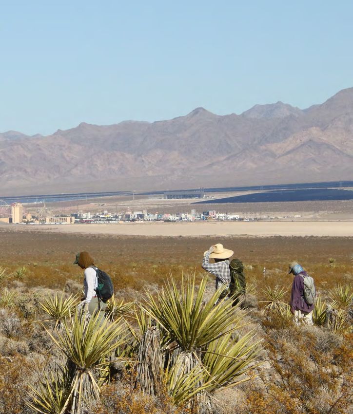
Cover photo: View of field team searching for tortoises in northern Ivanpah Valley, on the border
between California and Nevada and central to the Mojave Desert ecoregion. This area is an
important habitat connectivity corridor for the Mojave desert tortoise. Photograph by T.C. Esque,
U.S. Geological Survey, October 5, 2019.
Connectivity of Mojave Desert Tortoise
Populations: Management Implications for
Maintaining a Viable Recovery Network

By Roy C. Averill-Murray, Todd C. Esque, Linda J. Allison, Scott Bassett,
Sarah K. Carter, Kirsten E. Dutcher, Steven J. Hromada, Ken E. Nussear, and
Kevin Shoemaker

Wildlife Program
Prepared in cooperation with the U.S. Fish and Wildlife Service

Open-File Report 2021–1033

U.S. Department of the Interior
U.S. Geological Survey
U.S. Geological Survey, Reston, Virginia: 2021 For more information on the USGS—the Federal source for science about the Earth, its natural and living resources, natural hazards, and the environment—visit https://www.usgs.gov or call 1–888–ASK–USGS. For an overview of USGS information products, including maps, imagery, and publications, visit https://store.usgs.gov/. Any use of trade, firm, or product names is for descriptive purposes only and does not imply endorsement by the U.S. Government. Although this information product, for the most part, is in the public domain, it also may contain copyrighted materials as noted in the text. Permission to reproduce copyrighted items must be secured from the copyright owner. Suggested citation: Averill-Murray, R.C., Esque, T.C., Allison, L.J., Bassett, S., Carter, S.K., Dutcher, K.E., Hromada, S.J., Nussear, K.E., and Shoemaker, K., 2021, Connectivity of Mojave Desert tortoise populations—Management implications for maintaining a viable recovery network: U.S. Geological Survey Open-File Report 2021–1033, 23 p., https://doi.org/10.3133/ofr20211033. ISSN 2331-1258 (online)
iii

Acknowledgments
Mark Slaughter, Raul Morales, and the Desert Tortoise Management Oversight Group stimulated
the development of this white paper and discussion with them helped shape the content.
Brett Dickson and Miranda Gray provided advice on the application of the omnidirectional
connectivity model. Richard Spotts, Ed LaRue from the Desert Tortoise Council, and Russell
Scofield from the Bureau of Land Management in California provided useful comments on the
draft. The findings and conclusions in this article are those of the authors and do not necessarily
represent the views of the U.S. Fish and Wildlife Service.
v

Contents
Acknowledgments����������������������������������������������������������������������������������������������������������������������������������������iii
Executive Summary���������������������������������������������������������������������������������������������������������������������������������������1
Introduction����������������������������������������������������������������������������������������������������������������������������������������������������3
The Framework for Mojave Desert Tortoise Recovery����������������������������������������������������������������������������4
     Historic Population Connectivity��������������������������������������������������������������������������������������������������������4
     Design and Goals of the Current Network of Tortoise Conservation Areas�������������������������������4
     Challenges and Weaknesses of the Current Network of Tortoise Conservation Areas�����������4
     Functional Connectivity of Desert Tortoise Populations Across the Landscape�����������������������6
     Structure and Dynamics of Desert Tortoise Populations���������������������������������������������������������������6
     Effectively Connecting Current Desert Tortoise Habitat to Recover Populations����������������������8
Recent Research Relevant to Desert Tortoise Habitat and Connectivity���������������������������������������������8
Management Implications���������������������������������������������������������������������������������������������������������������������������9
     (1) Management of All Desert Tortoise Habitat for Persistence and Connectivity��������������������9
     (2) Limitations on Landscape-level Disturbance Across Habitat Managed for the
              Desert Tortoise�����������������������������������������������������������������������������������������������������������������������10
     (3) Minimization of Mortality from Roads and Maximization of Passage Under Roads����������14
     (4) Adaptation of Management Based on New Information�������������������������������������������������������14
Summary�������������������������������������������������������������������������������������������������������������������������������������������������������14
References Cited�����������������������������������������������������������������������������������������������������������������������������������������15
Appendix 1. Recent Desert Tortoise Habitat and Connectivity Models����������������������������������������������19

Figures
         1.     Map showing population trends and abundance of adult Mojave desert
                tortoises within tortoise conservation areas���������������������������������������������������������������������������5
         2.     Images showing diagrammatic representation of inter-patch habitat
                connectivity of Mojave desert tortoises�����������������������������������������������������������������������������������7
         3.     Graph showing observations of live Mojave desert tortoises from the U.S. Fish
                and Wildlife Service range-wide monitoring program relative to the proportion
                of development in the surrounding landscape within 1 kilometer of the
                observation location���������������������������������������������������������������������������������������������������������������������9
         4.     Map showing desert tortoise conservation areas and linkages in the California
                Desert Renewable Energy Conservation Plan�����������������������������������������������������������������������11
         5.     Map showing tortoise conservation areas, linkages, and other habitat managed
                for desert tortoise population connectivity in Nevada, Utah, and Arizona�����������������������13

Tables
         1.     Surface-disturbance caps in desert tortoise conservation areas and linkages
                in the California Desert Renewable Energy Conservation Plan������������������������������������������12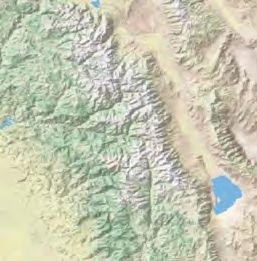
vi

     Conversion Factors
     U.S. customary units to International System of Units

              Multiply                   By                  To obtain
                                        Area
      acre                          4,047            square meter (m2)
      acre                               0.4047      hectare (ha)
      acre                               0.004047 square kilometer (km2)
      square mile (mi2)               259.0          hectare (ha)
      square mile (mi2)                  2.590       square kilometer (km2)
      mile                               1.609       kilometer

     International System of Units to U.S. customary units

              Multiply                   By                  To obtain
                                        Area
      square meter (m2)                0.0002471     acre
      hectare (ha)                     2.471         acre
      square kilometer (km2)       247.1             acre
      hectare (ha)                     0.003861      square mile (mi2)
      square kilometer (km2)           0.3861        square mile (mi2)
      kilometer                        0.6214        mile

     Abbreviations
     DRECP           Desert Renewable Energy Conservation Plan
     TCA             tortoise conservation area
     USFWS           U.S. Fish and Wildlife Service
Connectivity of Mojave Desert Tortoise Populations:
Management Implications for Maintaining a Viable
Recovery Network

By Roy C. Averill-Murray1, Todd C. Esque2, Linda J. Allison1, Scott Bassett3, Sarah K. Carter2,
Kirsten E. Dutcher3, Steven J. Hromada3, Ken E. Nussear3, Kevin Shoemaker3

                                                                            areas. Fragmentation exacerbates negative population
Executive Summary                                                           trends by breaking large continuous populations into
                                                                            smaller isolated populations. Connectivity within
     The historic distribution of Mojave desert tortoises                   large populations can enhance resilience to localized
(Gopherus agassizii) was relatively continuous across the                   disturbances due to rescue by neighboring individuals.
range, and the importance of tortoise habitat outside of                    In contrast, smaller fragmented populations are resistant
designated tortoise conservation areas (TCAs) to recovery                   to rescue by their isolation and thus could suffer
has long been recognized for its contributions to supporting                irreversible declines to extirpation from a variety of
gene flow between TCAs and to minimizing impacts and                        threats and stochastic events. Enhanced threat reduction
edge effects within TCAs. However, connectivity of Mojave                   to reverse declines within TCAs and to maintain
desert tortoise populations has become a concern because                    occupied habitat in the surrounding matrix would help
of recent and proposed development of large tracts of desert                reduce the variability in population growth rates and
tortoise habitat that cross, fragment, and surround designated              improve the resilience of protected populations even
conservation areas. This paper summarizes the underlying                    while implementing efforts to improve connectivity.
concepts and importance of connectivity for Mojave desert
tortoise populations by reviewing current information                        Each TCA has unique strengths and weaknesses
on connectivity and providing information to managers                  regarding its ability to support minimum sustainable
for maintaining or enhancing desert tortoise population                populations based on areal extent and its ability to support
connectivity as they consider future proposals for development         population increases based on landscape connection with
and management actions.                                                adjacent populations. Considering how proposed projects
     Maintaining an ecological network for the Mojave desert           (inside or outside of TCAs) affect connectivity and the ability
tortoise, with a system of core habitats (TCAs) connected              of TCAs to support at least 5,000 adult tortoises (the numerical
by linkages, is necessary to support demographically viable            goal for each TCA) could help managers to maintain the
populations and long-term gene flow within and between                 resilience of TCAs to population declines. The same project,
TCAs. There are four points for wildlife and land-management           in an alternative location, could have very different impacts on
agencies to consider when making decisions that could                  local and regional populations. For example, within the habitat
affect connectivity of Mojave desert tortoise populations (for         matrix surrounding TCAs, narrowly delineated corridors
example, in updating actions in resource management plans              may not allow for natural population dynamics if they do not
or amendments that could help maintain or restore functional           accommodate overlapping home ranges along most of their
connectivity in light of the latest information):                      widths so that tortoises reside, grow, find mates, and produce
                                                                       offspring that can replace older tortoises. In addition, most
  1. Management of all desert tortoise habitat for                     habitat outside TCAs may receive more surface disturbance
     persistence and connectivity. Desert tortoise populations         than habitat within TCAs. Therefore, managing the entire
     continue to decline within most TCAs, and it is unlikely          remaining matrix of desert tortoise habitat for permeability
     that trends are better in populations outside protected           may be better than delineating fixed corridors. These
                                                                       concepts apply, especially given uncertainty about long-term
                                                                       condition of habitat, within and outside of TCAs under a
 1Desert   Tortoise Recovery Office, U.S. Fish and Wildlife Service.
                                                                       changing climate.
 2U.S.   Geological Survey.
 3University   of Nevada, Reno.
2   Connectivity of Mojave Desert Tortoise Populations: Management Implications for Maintaining a Viable Recovery Network

     Ultimately, questions such as “What are the critical               that provide additional population connectivity along
linkages that need to be protected?” could be better framed as          the western flank of the Spring Mountains.
“How can we manage the remaining habitat matrix in ways
that sustain ecological processes and habitat suitability for         c. In a recent study that analyzed 13 years of desert
special status species?” Land-management decisions made in               tortoise monitoring data, nearly all desert tortoise
the context of the latter question may be more conducive to              observations were at sites in which 5 percent or less
maintenance of a functional ecological network.                          of the surrounding landscape within 1 kilometer
                                                                         was disturbed (Carter and others, 2020a). To help
   2. Limitations on landscape-level disturbance across                  maintain tortoise habitability and permeability
      habitat managed for the desert tortoise. Clearly                   across all other non-conservation-designated
      delineating habitat linkages and differentiating them              tortoise habitat, all surface disturbance could be
      from non-delineated areas by the uses that are permitted           limited to less than 5-percent development per
      or prohibited within them by specific management                   square kilometer because the 5-percent threshold
      guidelines can help achieve functional connectivity. Such          for development is the point at which tortoise
      guidelines would be most effective if they considered              occupation drops precipitously (Carter and others,
      and accounted for all surface disturbances (for example,           2020a). However, although individual desert
      temporary disturbances such as fiberoptic lines or                 tortoises were observed at development levels up to
      off-highway vehicle routes, right-of-ways, utility-scale           5 percent, we do not know the fitness or reproductive
      solar development, urbanization) to the extent possible.           characteristics of these individuals. This level of
      A weighted framework that varies with the permanence               development also may not allow for long-term
      or severity of the disturbance, and can be additive to             persistence of healthy populations that are of
      quantify cumulative effects, could be useful (Xiong,               adequate size needed for demographic or functional
      2020). For example, minor roads can alter tortoise                 connectivity; therefore, a conservative interpretation
      movements independently of other features (Peaden                  suggests that, ideally, development could be lower.
      and others, 2017; Hromada and others, 2020), but if the            Lower development levels would be particularly
      isolated dirt road is accompanied by a powerline that              useful in areas within the upper 5th percentile
      encourages raven predation (Xiong, 2020), then the                 of connectivity values modeled by Gray and
      two features together may be additive. Ignoring minor              others (2019).
      or temporary disturbance on the landscape could result
      in a cumulatively large impact that is not explicitly           d. Reducing ancillary threats in places where
      acknowledged (Goble, 2009); therefore, understanding               connectivity is restricted to narrow strips of habitat,
      and quantifying all surface disturbance on a given                 for example, narrow mountain passes or vegetated
      landscape is prudent.                                              strips between solar development, could enhance
                                                                         the functionality of these vulnerable linkages. In
       a. In California, the Bureau of Land Management                   such areas, maintaining multiple, redundant linkages
          established 0.1–1.0 percent caps on new                        could further enhance overall connectivity.
          surface-disturbance for TCAs and mapped linkages
          that address the issues described in number 1 of        3. Minimization of mortality from roads and
          this list.                                                 maximization of passage under roads. Roads pose a
                                                                     significant threat to the long-term persistence of local
       b. Nevada, Utah, and Arizona currently do not have            tortoise populations, and roads of high traffic volume
          surface-disturbance limits. Limits comparable to           lead to severe population declines, which ultimately
          those in the Desert Renewable Energy Conservation          fragments populations farther away from the roads.
          Plan (DRECP) would be 0.5 percent within TCAs              Three points (a.–c.) pertain to reducing direct mortality
          and 1 percent within the linkages modeled by               of tortoises on the many paved roads that cross desert
          Averill-Murray and others (2013). Limits in some           tortoise habitat and to maintaining a minimal level of
          areas of California within the Desert Renewable            permeability across these roads:
          Energy Conservation Plan, such as Ivanpah Valley,
          are more restrictive, at 0.1 percent. Continuity            a. Tortoise-exclusion fencing tied into culverts,
          across the state line in Nevada could be achieved              underpasses, overpasses, or other passages below
          with comparable limits in the adjacent portion of              roads in desert tortoise habitat, would limit vehicular
          Ivanpah Valley, as well as the Greater Trout Canyon            mortality of tortoises and provide opportunities for
          Translocation Area and the Stump Springs Regional              movement across the roads. Installation of shade
          Augmentation Site. These more restrictive limits               structures on the habitat side of fences installed
          would help protect remaining habitat in the major              in areas with narrow population-depletion zones
          interstate connectivity pathway through Ivanpah                would limit overheating of tortoises that may pace
          Valley and focal areas of population augmentation              the fence.
Introduction 3
b. Passages below highways could be maintained vegetation intact whenever possible, or if not
or retrofitted to ensure safe tortoise access, for possible, mowing the site, allowing vegetation
example, by filling eroded drop-offs or modifying to re-sprout, and managing weeds; and allowing
erosion-control features such as rip-rap to make tortoises to occupy the sites; and
them safer and more passable for tortoises.
Wildlife management agencies could work with d. The design and frequency of underpasses necessary
transportation departments to develop construction to maintain functional demographic and genetic
standards that are consistent with hydrologic/erosion connectivity across linear features, like highways.
management goals, while also incorporating a design
and materials consistent with tortoise survival and
passage and make the standards widely available.
The process would be most effective if the status Introduction
of passages was regularly monitored and built into
Connectivity of Mojave desert tortoise
management plans.
(Gopherus agassizii) populations has become an issue of
c. Healthy tortoise populations along fenced highways increasing concern due to recent and proposed development
could be supported by ensuring that land inside of large tracts of desert tortoise habitat that cross, fragment,
tortoise-exclusion fences is not so degraded that it and surround designated conservation areas. Much of this
leads to degradation of tortoise habitat outside the development is a result of the recent renewable energy
exclusion areas. For example, severe invasive plant boom, but also includes long-planned urban expansion and
infestations inside a highway exclusion could cause infrastructure projects that are reaching the implementation
an increase of invasive plants outside the exclusion phase. Researchers have studied the implications of existing
area and degrade habitat; therefore, invasive plants tortoise conservation areas becoming isolated due to this
inside road rights of way could be mown or treated development and have modeled past, current, and potential
with herbicide to limit their spread into adjacent future population connectivity across the desert tortoise’s
tortoise habitat and minimize the risk of these plants range (see later in the text). Managers have incorporated much
carrying wildfires into adjacent habitat. of the available information into individual planning decisions
(for example, Desert Renewable Energy and Conversation
4. Adaptation of management based on new information. Plan Land Use Plan Amendment to the California Desert
Future research will continue to build upon and refine Conservation Plan of 1980 [DRECP], draft Apple Valley
models related to desert tortoise population connectivity Habitat Conservation Plan). However, general principles for
and develop new ones. New models could consider maintaining functionally connected desert tortoise populations
landscape levels of development and be constructed such have not been synthesized to assist with a comprehensive,
that they share common foundations to support future species-wide analysis, and several existing land-management
synthesis efforts. If model development was undertaken plans lack the focus on desert tortoise population connectivity
in partnership with entities that are responsible for present in other plans such as the DRECP. The Management
management of desert tortoise habitat, it would facilitate Oversight Group for the Mojave Desert Tortoise requested
incorporation of current and future modeling results guidance to clarify the needs of the Mojave desert tortoise
into their land management decisions. There are specific for habitat connectivity from the Western Ecological
topics that may be clarified with further evaluation: Research Center of the U.S. Geological Survey and the
Recovery Office of the U.S. Fish and Wildlife Service for
a. The effects of climate change on desert tortoise
the Mojave Desert Tortoise. This report is a collaboration
habitat, distribution, and population connectivity;
to provide that guidance by summarizing the underlying
b. The effects of large-scale fires, especially within concepts and importance of connectivity for Mojave desert
repeatedly burned habitat, on desert tortoise tortoise populations by (1) reviewing current information
distribution and population connectivity; on connectivity and (2) providing information to managers
for maintaining or enhancing desert tortoise population
c. The ability of solar energy facilities or similar connectivity as they consider future proposals for development
developments to support tortoise movement and and management actions.
presence by leaving washes intact; leaving native4 Connectivity of Mojave Desert Tortoise Populations: Management Implications for Maintaining a Viable Recovery Network
The Framework for Mojave Desert are distributed across the range in a pattern designed
to capture this breadth (U.S. Fish and Wildlife
Tortoise Recovery Service, 2011).
• Redundancy, having multiple protected populations
Historic Population Connectivity within representative units, protects against
The historic distribution of Mojave desert tortoises was catastrophic loss of any particular population. In
relatively continuous across the range, broken only by major the case of the Mojave desert tortoise, each of the
topographic barriers, such as the Baker Sink and Death Valley, recovery units identified in the 2011 recovery plan
California, and the Spring Mountains, Nevada (Germano contain multiple TCAs, except for the Upper Virgin
and others, 1994; Nussear and others, 2009, respectively). River Recovery Unit in Utah (U.S. Fish and Wildlife
Although desert tortoises generally do not move long distances Service, 2011).
over their lifetimes, historically, modest dispersal and • Resilience represents the ability of populations
connected home ranges occurred over a relatively continuous to recover from stochastic setbacks, such as
distribution across the tortoise’s range. This contiguous drought-induced population declines or localized
distribution fostered historically high levels of gene flow and disease outbreaks. To maintain resilience, TCAs
a population structure characterized as isolation-by-distance were envisioned to sustain a population of at least
(Murphy and others, 2007; Hagerty and Tracy, 2010; Hagerty 5,000 adult tortoises (U.S. Fish and Wildlife Service,
and others, 2011). Maintaining functionally connected 1994). In situations where a critical habitat unit was
landscapes is necessary to conserve historic genetic gradation smaller than the threshold of 1,295 square kilometers
(Frankham, 2006). Large, connected landscapes also are (km2), or if the number of tortoises was found to be
necessary to facilitate natural range shifts in response to fewer than 5,000, land management was expected to
climate change (Krosby and others, 2010; National Fish, maintain connectivity to larger populations outside the
Wildlife, and Plants Climate Adaptation Partnership, 2012; critical habitat unit and to other critical habitat units
Hilty and others, 2020). Nevertheless, though gene flow and (U.S. Fish and Wildlife Service, 1994).
adaptive capacity are critically important in the long term, the
need for extensive, unfragmented habitat is of more immediate The importance of tortoise habitat outside of TCAs,
concern for supporting populations that are demographically to recovery, has long been recognized for its contributions
viable on time scales relative to management (Kuo and to supporting gene flow among TCAs and to minimizing
Janzen, 2004). impacts and edge effects within TCAs (U.S. Fish and Wildlife
Service, 1994, 2011). This dependence, on a reserve design
of protected areas supported by surrounding areas that are not
Design and Goals of the Current Network of necessarily protected, is considered the linchpin of sustaining
Tortoise Conservation Areas a resilient protected area network (U.S. Fish and Wildlife
Service, 2011).
Tortoise conservation areas (TCAs1) form the foundation
of the desert tortoise recovery strategy and are centered
around 12 designated critical habitat units that range in area
Challenges and Weaknesses of the Current
from approximately 220 to 4,131 square miles (U.S. Fish Network of Tortoise Conservation Areas
and Wildlife Service, 2011). Effective conservation areas are
designed to support species viability according to ecological When the original recovery plan was developed, there
concepts of representation, redundancy, and resilience were no reliable abundance estimates for tortoises in any
(U.S. Fish and Wildlife Service, 1994, 2016; Shaffer and critical habitat unit. However, one unit in particular, the
Stein, 2000). Upper Virgin River Critical Habitat Unit, was insufficient
in size to support the necessary 5,000 adult tortoises, thus,
• Representation captures the breadth of genetic or it was identified as requiring intensive management since
ecological diversity of a species, and recovery units its establishment (U.S. Fish and Wildlife Service, 1994).
Range-wide monitoring since 2004 (1999 in Upper Virgin
River) provides population estimates and recent changes in
1Tortoise conservation areas include desert tortoise habitat within
designated critical habitat, Desert Wildlife Management Areas, Areas
tortoise density for each TCA. As of 2014, 11 of 17 TCAs
of Critical Environmental Concern, Grand Canyon-Parashant National had negative population trends, and 8 of 17 were estimated
Monument, Desert National Wildlife Refuge, National Park Service lands, to contain fewer than 5,000 adult tortoises (Allison and
Red Cliffs Desert Reserve, and other conservation areas or easements McLuckie, 2018; fig. 1).
managed for desert tortoises (U.S. Fish and Wildlife, 2011).The Framework for Mojave Desert Tortoise Recovery 5
California Nevada Utah
Arizona
PACIFIC OCEAN
0 50 100 MILES
ME X IC O 0 50 100 KILOMETERS
Image source: National Geographic Society. Copyright:© 2013 National Geographic Society, i-cubed.
EXPLANATION
2014 Abundance 2009 USGS habitat model 2004–14 Trend (%/yr)
(adult tortoises) High probability –10.4
1,241–4,874 –9.5 to –6.8
Low probability
–4.7 to –3.1
5,146–9,304
Department of 4.8 to 21.6
10,469 Defense
Monitoring strata
18,220 Nevada National
Security Site Recovery units
Highways
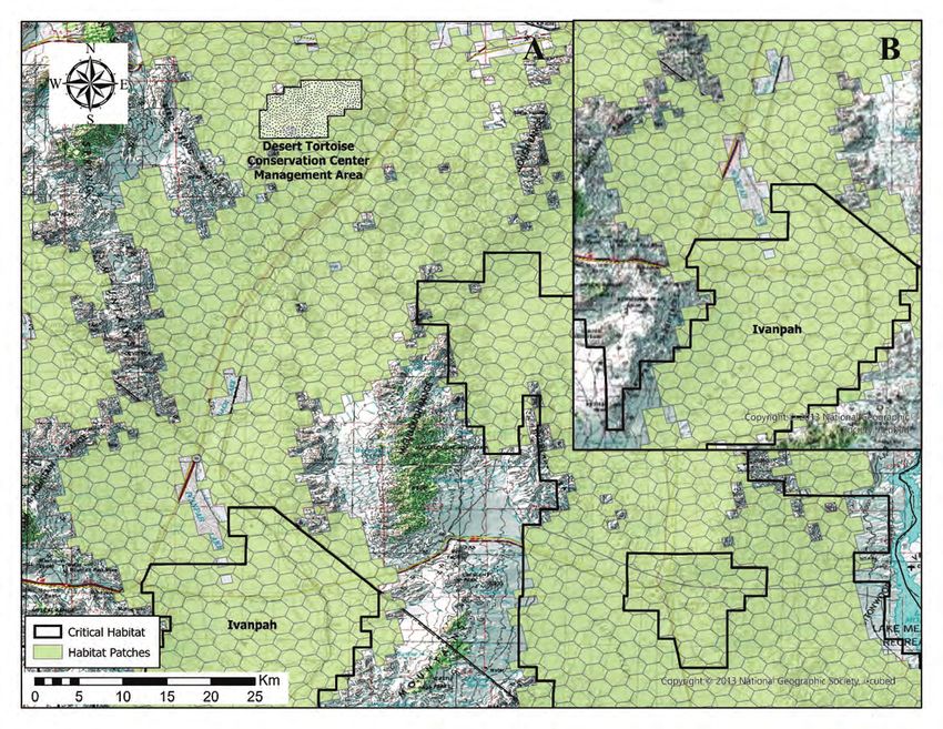
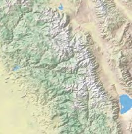
Figure 1. Population trends and abundance of adult Mojave desert tortoises within tortoise conservation areas (TCAs).
Yellow lines represent major roads and highways. Color ramp from white to green represents low to high probability of tortoise
presence, respectively.6 Connectivity of Mojave Desert Tortoise Populations: Management Implications for Maintaining a Viable Recovery Network
In addition to concerns about the status of tortoise in the absence of appropriate underpasses or overpasses
populations within the TCAs, the configuration of several (Peaden and others, 2015; Rautsaw and others, 2018; Dutcher
TCAs is inconsistent with optimal reserve design. The and others, 2020a; Hromada and others, 2020).
theoretically optimal reserve shape would be circular to The features listed in the previous paragraph are
minimize the perimeter and potential edge effects relative to widespread across the Mojave Desert; for example, almost all
the area because the quality of habitat within conservation TCAs are divided internally or separated from adjacent units
areas can be affected by factors present outside conservation by major roads and highways (fig. 1). Abundance of tortoise
area boundaries (Harrison and Bruna, 1999; Environmental sign decreases closer to unfenced roadways, resulting in a
Law Institute, 2003; Radeloff and others, 2010). For example, zone of population depletion of up to 4 kilometers (km) from
subsidized predators within the urban-wildland interface can highways with the highest traffic volumes (Hoff and Marlow,
affect tortoise populations well within TCAs (Kristan and 2002; Boarman and Sazaki, 2006; Nafus and others, 2013;
Boarman, 2003; Esque and others, 2010). However, to capture Peaden and others, 2015). These depleted zones effectively
the actual pattern of suitable habitat while accommodating eliminate or severely reduce connectivity of tortoise
land ownership considerations, all TCAs have complex populations across the range. Many miles of tortoise-barrier
perimeters, often with narrow extensions or projections into fencing have been installed along roads, primarily within
relatively unprotected habitat (fig. 1). This is partly because, TCAs, with this fencing connected to culverts. Although
prior to TCA establishment, the landscape already had many individual tortoises cross through culverts (Boarman and
inholdings and disturbances that were avoided because they others, 1998; Hromada and others, 2020), the effectiveness of
rendered the habitat incompatible for tortoise use. The result culverts in mitigating the fragmenting effects of highways at a
of this configuration is a network of land parcels of variable population scale is unknown. Even culverts designed to reduce
habitat quality and tortoise permeability (Gray and others, resistance across linear barriers can be ineffective if materials
2019). All of these issues emphasize the importance of such as rip-rap of talus-sized rocks prevent access by tortoises.
maintaining, and ideally increasing, the availability of habitat
connectivity within and among TCAs.
Structure and Dynamics of Desert
Tortoise Populations
Functional Connectivity of Desert Tortoise
Populations Across the Landscape Desert tortoises do not occur at uniform densities across
the landscape (Krzysik, 2002). Local population abundances
Connectivity can be viewed as the degree to which fluctuate asynchronously because of differences in habitat
regional landscapes, encompassing a variety of natural, quality and variability in precipitation patterns, such as
semi-natural, and developed land-cover types, are conducive localized declines attributed to drought, disease, or predation
to wildlife movement and to sustaining ecological processes events (Peterson, 1994; Longshore and others, 2003; Tracy
(Ament and others, 2014; Hilty and others, 2020). and others, 2004; Esque and others, 2010; Emblidge and
Functionally, connectivity describes the degree to which others, 2015) or stochastic population dynamics (U.S. Fish and
landscapes facilitate or impede the movement of organisms Wildlife Service, 2011). Adjacent habitat patches of sufficient
and processes (Meiklejohn and others, 2010; Hilty and others, quality to support healthy tortoise populations are necessary
2020). Decreased connectivity results from various degrees of for local population declines or extinctions to be rescued
landscape resistance. For example, natural linear features that by recolonization (Fahrig and Merriam, 1994). As habitat is
entirely preclude movement for tortoises include impassable lost and fragmented, habitat patches become smaller, patch
vertical cliffs, talus slopes, and large rivers. Semi-permeable populations (for example, clusters of tortoises) have fewer
features include natural habitats with questionably sufficient tortoises and become more disjunct, extinction probabilities
thermal cover, such as burned areas or playa edges, or other within patches increase, and the number of occupied patches
features typical of the urban-wildland interface, such as decreases (Fahrig, 2002; Ovaskainen and others, 2002).
ploughed lots, roads, railways, and large berms, all of which As described earlier, tortoise populations adjacent to and
can act as filters that reduce connectivity between populations contiguous with populations within TCAs are essential for
long-term species viability and recovery given the limitations
of the existing TCA reserve design (fig. 2).The Framework for Mojave Desert Tortoise Recovery 7
C
EXPLANATION
Critical habitat
Habitat patches
Image source: National Geographic Society. Copyright:© 2013 National Geographic Society, i-cubed.
Figure 2. Inter-patch habitat connectivity of Mojave desert tortoises. Each hexagon represents a 259-hectare (640-acre) habitat
patch. A, Historically interconnected habitat constrained by major topographic barriers; B, Inter-patch relationships across a part
of the landscape are represented by red arrows; and C, Reduction in patch connections occurs with habitat loss and fragmentation,
conceptually represented by gray patches.8 Connectivity of Mojave Desert Tortoise Populations: Management Implications for Maintaining a Viable Recovery Network
Large expanses of high-quality habitat are necessary to of TCAs over multiple generations (Tracy and others,
increase the likelihood that tortoises from local areas, with 2004). Low-mobility species, such as the desert tortoise, are
higher recruitment, will emigrate and repopulate (or “rescue”) considered “corridor dwellers” that may spend their entire life
adjacent areas of suitable habitat (for example, within TCAs) within corridors (Beier and Loe, 1992). In effect, low mobility
that may have fewer tortoises due to low recruitment or high of the species means that interconnected local populations of
mortality (Germano and Joyner, 1988; Morafka, 1994; Tracy tortoises must persist across the landscape to ensure overall
and others, 2004). This rescue effect has been described and species persistence (fig. 2B).
studied using island biogeography concepts and principles In contrast, passage species may move through corridors
that lead us to expect that the probability a population will between protected areas in days or weeks, even at large
persist is related to the size and isolation of the habitat patch spatial scales (Beier and Loe, 1992). Though individual desert
on which it exists (MacArthur and Wilson, 1967; Brown and tortoises can move many kilometers in one season (Berry,
Kodric-Brown, 1977). Figure 2B provides an example of 1986; Edwards and others, 2004), this type of movement has
the historical relationship between habitat patches for desert been observed in large, open areas rather than a long (for
tortoises in the Mojave Desert. Patches suffering localized example, tens of kilometers), narrow strip of habitat a few
declines in tortoise numbers could be recolonized by tortoises meters—or even a few hundred meters—wide. Tortoises may
emigrating from adjacent patches. As habitat is degraded, lost, traverse short culverts and thereby navigate the otherwise
or fragmented by anthropogenic barriers, however, inter-patch absolute barrier of a fenced road (Boarman and others, 1998)
relationships may break down, resulting in a decreased or may occupy narrow mountain passes (Dutcher and others,
likelihood that recolonizations will occur. In short, tortoises 2020b; Hromada and others, 2020), but tortoise movement
within remaining patches that have fewer connections are patterns do not lead us to expect that a tortoise in one TCA
more likely to be extirpated and less likely to be replaced than would traverse a long narrow strip of preserved desert
tortoises inhabiting patches surrounded by permeable habitats vegetation to another TCA many kilometers distant in its
with intact connections (fig. 2C; Lefkovitch and Fahrig, 1985). lifetime. For all these reasons, habitat linkages among TCAs
Such fragmentation could isolate and reduce the viability of must be wide enough to sustain multiple home ranges or local
regional populations, including those within TCAs, creating clusters of resident tortoises (Beier and others, 2008; Morafka,
an “extinction debt” (Kuussaari and others, 2009; Hylander 1994), while accounting for edge effects, in order to sustain
and Ehrlén, 2013) that extends well beyond the perimeters regional tortoise populations.
of parcels of lost habitats. Rescue of unoccupied habitat
patches may not occur, or may be delayed, if few tortoises
disperse from nearby small or declining populations (Adler
and Nuernberger, 1994). Unoccupied patches present a special Recent Research Relevant to Desert
problem if the source of the decline is unknown because Tortoise Habitat and Connectivity
evidence is lacking to indicate whether the decline was due
to temporary conditions for the occupants or if the site can A variety of spatial habitat models have been developed
no longer sustain tortoises. Obtaining better information for the management of desert tortoise habitat, including
about habitat quality requirements may resolve some of models describing habitat suitability, levels of development
this uncertainty. within modeled habitat, landscape genetics, tortoise habitat
linkages, and connectivity (appendix 1; figs. 1.1–1.4). These
models have been used for project-proponent and regulatory
Effectively Connecting Current Desert Tortoise planning, establishing survey requirements, evaluating reports
Habitat to Recover Populations for project compliance, and as base inputs for subsequent
spatial models. Furthermore, many of the natural resource
The patterns of population distribution and dynamics layers developed for these models (for example, soil texture
described earlier represent those of a “patchy” metapopulation layer by Nowicki and others, 2019; wash layers by Gray and
(Harrison, 1991). For species with this type of metapopulation others, 2019) have been applied to understand habitats for
dynamic to persist over the long term, connectivity between other species of management concern across the southwestern
patches must be provided through contiguous viable habitat. United States (for example, Mohave Ground Squirrel
The Mojave desert tortoise requires interconnected habitat by Inman and others, 2013; multiple species and energy
across its range to sustain populations within and outside development by Vandergast and others, 2013).Management Implications 9
Spatial models that focus on habitat connectivity
that are in development were presented at the annual
Management Implications
symposium of the Desert Tortoise Council in February 2020 Maintaining an ecological network (recovery network)
(https://deserttortoise.org/wp-content/uploads/ for the Mojave desert tortoise, with a system of core habitats
ABSTRACTS_2020-DTC-FINAL-Feb72020.pdf), and (TCAs) connected by linkages (Hilty and others, 2020), is
included syntheses of habitat status (Nussear and others, necessary to support demographically viable populations
2020), genetic responses to landscape disturbances (Dutcher and long-term gene flow within and between TCAs. There
and others, 2020a), desert tortoise movements (Hromada and are three points for wildlife and land-management agencies
others, 2020), demographics (Shoemaker and others, 2020), to consider when making decisions that could affect
and alternative future habitat scenarios (Bassett and others, connectivity of Mojave desert tortoise populations (for
2020). The development of these models is ongoing and example, in updating actions in resource management plans
dynamic. For example, three of the ‘working’ models have or amendments that could help maintain or restore functional
been published since the presentation in February (Dutcher connectivity in light of the latest information).
and others, 2020b; Carter and others, 2020a; Hromada and
others, 2020). In particular, these studies reinforced evidence
of reduced movements and gene flow across linear barriers (1) Management of All Desert Tortoise Habitat
(highways and railroads), while reporting movements and for Persistence and Connectivity
gene flow across mountain passes (Dutcher and others,
2020b), and documented limited tortoise observations in Desert tortoise populations continue to decline within
areas with greater than 5-percent surface disturbance per km2 most TCAs (Allison and McLuckie, 2018), and it is unlikely
(fig. 3; Carter and others, 2020a). For these models, surface that trends are better in populations outside protected areas.
disturbance was derived for nationally available datasets, and Fragmentation exacerbates negative trends by increasing the
does not necessarily include temporary disturbance. probability that isolated populations will suffer irreversible
Several additional models are still in development declines due to stochastic (unpredictable) effects acting on
but can be accessed as they become ready for distribution. their smaller local abundances, especially when combined
Available data and modelling, along with the models still with multiple external threats within the population fragments.
in development, will further inform management agencies Enhanced threat reduction to reverse declines within TCAs
seeking to address connectivity issues for the Mojave and maintained occupied habitat in the surrounding matrix
desert tortoise. would help reduce the variability in population growth rates
and improve the resilience of protected populations, while
implementing efforts to improve connectivity.
Live animals Each TCA has unique strengths and weaknesses
3.0 regarding its ability to support minimum sustainable
populations based on areal extent, and its ability to support
population increases based on landscape connection with
Number of animals
2.0 adjacent populations. Considering how proposed projects
(inside or outside of TCAs) affect connectivity and the ability
of TCAs to support at least 5,000 (the numerical goal for
1.0
each TCA) adult tortoises could help managers maintain the
resilience of TCAs to population declines. The same project
0.0 in an alternative location may have very different impacts on
local or regional connectivity. For example, within the habitat
0 5 10 15 20 matrix surrounding TCAs, narrowly delineated corridors
Terrestrial development index may not allow for natural population dynamics if they do not
accommodate overlapping home ranges along most of their
Figure 3. Observations of live Mojave desert tortoises from the widths so that tortoises reside, grow, find mates, and produce
U.S. Fish and Wildlife Service range-wide monitoring program offspring that can replace older tortoises (Beier and Loe, 1992;
relative to the proportion of development in the surrounding Beier, 2018). In addition, most habitat outside TCAs may
landscape within 1 kilometer (km) of the observation location receive more surface disturbance than habitat within TCAs
(Terrestrial Development Index). A development index value of 5 (Carter and others, 2020a). Therefore, managing the entire
indicates that 5 percent of the area within 1 km of that location remaining matrix of desert tortoise habitat for permeability
has been altered by development. Adapted from Carter and may be better than delineating fixed corridors (Beier, 2018;
others (2020a). Gray and others, 2019). These concepts apply, especially given
uncertainty about long-term condition of habitat within and
outside of TCAs under a changing climate.10 Connectivity of Mojave Desert Tortoise Populations: Management Implications for Maintaining a Viable Recovery Network
Ultimately, questions such as “What are the critical comparable limits in the adjacent portion of Ivanpah
linkages that need to be protected?” may be better framed as Valley, as well as the Greater Trout Canyon translocation
“How can we manage the remaining habitat matrix in ways area and the Stump Springs Regional Augmentation
that sustain ecological processes and habitat suitability for Site (fig. 5). These more restrictive limits help protect
special status species.” Land-management decisions made remaining habitat in the major interstate connectivity
in the context of the latter question could be more conducive pathway through Ivanpah Valley (Hagerty and others,
to maintenance of a functional ecological network and the 2011) and focal areas of population augmentation that
recovery of the Mojave desert tortoise. provide additional population connectivity along the
western flank of the Spring Mountains.
(2) Limitations on Landscape-level Disturbance c. In a recent study that analyzed 13 years of desert
Across Habitat Managed for the Desert Tortoise tortoise monitoring data, nearly all desert tortoise
observations were at sites in which 5 percent or
Clearly delineating habitat linkages and differentiating less of the surrounding landscape within 1 km was
them from non-delineated areas by the uses that are permitted disturbed (Carter and others, 2020a). To help maintain
or prohibited within them by specific management guidelines tortoise inhabitance and permeability across all other
can help achieve functional connectivity. Such guidelines non-conservation-designated tortoise habitat, all surface
would be most effective if they considered and accounted for disturbance could be limited to less than 5-percent
all surface disturbances (for example, temporary disturbances development per square kilometer because the 5-percent
such as fiberoptic lines or off-highway vehicle routes, threshold for development is the point at which tortoise
right-of-ways, utility-scale solar development, urbanization) to occupation drops precipitously (Carter and others,
the extent possible. A weighted framework that varies with the 2020a; fig. 3). However, it is important to note that
permanence or severity of the disturbance and can be additive 5 percent may not maintain population sizes needed
to quantify cumulative effects may be useful. For example, for demographic or functional connectivity; therefore,
minor roads can alter tortoise movements independently ideally, development thresholds should be lower.
of other features (Hromada and others, 2020; Peaden and Lower development thresholds would be particularly
others, 2017), but if the isolated dirt road is accompanied by useful in areas within the upper 5th percentile of
a powerline that encourages raven predation (Xiong, 2020), connectivity values modeled by Gray and others (2019;
the two features together may be additive. Ignoring minor fig. 1.3; fig. 5).
or temporary disturbance on the landscape could result in a However, although individual desert tortoises were
cumulatively large impact that is not explicitly acknowledged observed at development levels up to 5 percent, we do not
(Goble, 2009). Therefore, a commitment to understanding know the fitness or reproductive characteristics of these
and quantifying all surface disturbance on a given landscape individuals. This level of development also may not allow
is needed. for long-term persistence of healthy populations that are
a. In California, the Bureau of Land Management of adequate size needed for demographic or functional
established 0.1–1.0-percent new surface-disturbance connectivity; therefore, ideally development should be lower.
caps for TCAs and mapped linkages that address the This would be particularly useful in areas within the upper
issues described in the “(1) Management of All Desert 5th percentile of connectivity values modeled by Gray and
Tortoise Habitat for Persistence and Connectivity” others (2019).
section (fig. 4; table 1; U.S. Bureau of Land d. Reducing ancillary threats in places where connectivity
Management, 2016). is restricted to narrow strips of habitat, for example,
narrow mountain passes or vegetated strips between
b. Nevada, Utah, and Arizona currently do not have
solar development, could enhance the functionality of
surface-disturbance limits. Limits comparable to those
these vulnerable linkages. In such areas, maintaining
in the DRECP would be 0.5 percent within TCAs and
multiple, redundant linkages could further enhance
1 percent within the linkages modeled by Averill-Murray
overall connectivity. Attention to the spatial
and others (2013). Limits in some areas of California
configuration of allowed disturbances also would help
within the DRECP, such as Ivanpah Valley, are more
ensure that any existing bottlenecks to connectivity are
restrictive at 0.1 percent (fig. 4; table 1). Continuity
not severed.
across the state line in Nevada could be achieved withManagement Implications 11
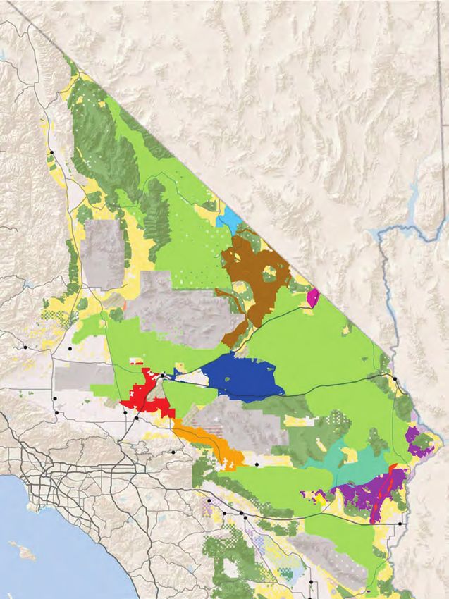
C EXPLANATION
a
li
fo Biological goals and objectives
rn
ia Names
6
Tortoise conservation areas
266
Chemehuevi to Chuckwalla linkage
Nevada DVNP to Nevada test site linkage
Fremont-Kramer to Ord-Rodman
linkage
Ivanpah Valley linkage
JTNP and Pinto Mountains
136 to Chemehuevi linkage
Owens Valley 190
Ord-Rodman to Joshua Tree
National Park linkage
Ord-Rodman to Superior-Cronese
to Mojave National Preserve
127 Pinto Wash linkage
Arizona
178 Superior-Cronese to MNP to
s Shadow Valley to DVNP
in
ta
n High priority Colorado Desert
u
o Central Mojave
i
M habitat
p
a 395
202 h Base layers
c California City
a
h 58
T
e
Barstow
Legislatively and legally
Needles
West Mojave protected areas
40
Military expansion
Lancaster
14
Adelanto
Luc
mitigation lands
ern
Victorville e V
138
al ley Military
18
247
2 95
173
39 Open OHV areas -Imperial
330Big Bear Lake
405
134 210 38
sand dunes
27 66 Twentynine
605 57
110 Palms
142
60
Open OHV areas
90 71 Palm
91 Springs 177
213
710
22 243 Johnson Valley OHV
215 Coachella
55 shared use area
East Riverside
10
241 Palm
15 Desert Indio
73 74 Blythe
371
Ch
Tribal lands
oc
5 ola
79 111 te United States Bureau of
76 Mo
un
tai
ns Land Management
Calipatria
86
P a c i f i c 78
Imperial Valley NDAA China Lake
56 67 Brawley expansion
O c e a n Imperial 115
El Centro 8
Holtville CDCA plan boundary
Calexico
98
75 DRECP plan area
boundary
0 12.5 25 MILES ME X IC O
FIGURE D-16
DRECP BLM Land Use Plan Amendment
Desert Tortoise TCAs and Linkages
Sources: ESRI (2016); CEC (2013); BLM (2016); CDFW (2013); USFWS (2013) September 2016
Figure 4. Desert tortoise conservation areas (TCAs) and linkages in the California Desert Renewable Energy Conservation Plan
(U.S. Bureau of Land Management, 2016). Tortoise conservation areas are labeled according to table 1.12 Connectivity of Mojave Desert Tortoise Populations: Management Implications for Maintaining a Viable Recovery Network
Table 1. Surface-disturbance caps in desert tortoise conservation areas and linkages in the California Desert
Renewable Energy Conservation Plan (U.S. Bureau of Land Management, 2016).
[ACEC, Area of Critical Environmental Concern; CHU, critical habitat unit]
Disturbance cap
Location
(percentage)
Tortoise conservation area (numbers correspond to fig. 4)
1. Desert Tortoise Research Natural Area 0.1
2. Fremont-Kramer ACEC and CHU 0.5
3. Superior-Cronese ACEC and CHU 0.5
4. Ord-Rodman ACEC and CHU 0.5
5. Pinto Mountains ACEC and CHU 0.5
6. Chuckwalla ACEC and CHU 0.5
7. Chemehuevi Desert ACEC and CHU 0.5
8. Piute Valley ACEC and CHU 0.5
9. Shadow Valley ACEC 0.5
10. Ivanpah Valley ACEC (includes critical habitat on Bureau of Land Management land) 0.1
Desert tortoise linkages (see legend in fig. 4)
Ord-Rodman to Superior-Cronese to Mojave National Preserve 1
Superior-Cronese to Mojave National Preserve to Shadow Valley to Death Valley National Park 1
Joshua Tree National Park and Pinto Mountains to Chemehuevi 1
Death Valley National Park to Nevada National Security Site 1
Ivanpah Valley 0.1
Chemehuevi to Chuckwalla 0.1
Pinto Wash 0.1
Ord-Rodman to Joshua Tree National Park 0.5
Fremont-Kramer to Ord-Rodman 0.5
High-value Colorado Desert Habitat 1Management Implications 13
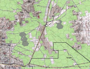
Image source: National Geographic Society. Copyright:© 2013 National Geographic Society, i-cubed. 0 50 100 MILES
0 50 100 KILOMETERS
EXPLANATION
Recovery units Ivanpah Valley Watershed
Critical habitat Omnidirectional connectivity model (5%)
5%)
Trout Canyon Translocation area ≤5
Stump Springs Augmentation Site ≤20
20.1–100
Department of Defense
Highways
Nevada National Security Site
Figure 5. Tortoise conservation areas, linkages, and other habitat managed for desert tortoise population connectivity in Nevada,
Utah, and Arizona.14 Connectivity of Mojave Desert Tortoise Populations: Management Implications for Maintaining a Viable Recovery Network
(3) Minimization of Mortality from Roads and (4) Adaptation of Management Based on
Maximization of Passage Under Roads New Information
Roads pose a significant threat to the long-term The models described herein have already been useful
persistence of local tortoise populations, and roads of high for informing management of tortoise habitat to support
traffic volume lead to severe population declines (Peaden, population recovery and connectivity. Future research will
2017), which ultimately fragments populations farther away continue to build upon and refine these models and develop
from the roads. Three points pertain to reducing direct new ones. New models could consider landscape levels of
mortality of tortoises on the many paved roads that cross development and be constructed such that they share common
desert tortoise habitat and maintaining a minimal level of foundations to support future synthesis efforts. If model
permeability across these roads. development was undertaken in partnership with entities that
a. Tortoise-exclusion fencing tied into culverts, underpasses are responsible for management of desert tortoise habitat, it
or overpasses, or other passages below roads in desert would facilitate incorporation of current and future modeling
tortoise habitat, would limit vehicular mortality of results into their land management decisions (Carter and
tortoises and would provide opportunities for movement others, 2020b). There are specific topics that could be clarified
across the roads (Boarman and others, 1997). Installation with further evaluation:
of shade structures on the habitat side of fences installed a. The effects of climate change on desert tortoise habitat,
in areas with narrow population-depletion zones would distribution, and population connectivity (Nussear and
limit overheating of tortoises that may pace the fence others, 2020; Shoemaker and others, 2020);
(Peaden and others, 2017).
b. The effects of large-scale fires, especially within
b. Passages below highways could be maintained or repeatedly burned habitat, on desert tortoise distribution
retrofitted to ensure safe tortoise access, for example, by and population connectivity;
filling eroded drop-offs or by modifying erosion-control
features, such as rip-rap, to make them safer and c. The ability of solar energy facilities or similar
more passable for tortoises. Wildlife management developments to support tortoise movement and
agencies could work with transportation departments to presence by leaving washes intact, leaving native
develop construction standards that are consistent with vegetation intact whenever possible, or if not possible,
hydrologic/erosion management goals, which would also mowing the site to allow vegetation to re-sprout,
maximize the potential for tortoise survival and passage managing weeds, and allowing tortoises to occupy the
and make the standards widely available. The process sites; and
would be most effective if the status of passages was d. The design and frequency of underpasses necessary
regularly monitored and built into management plans. to maintain functional demographic and genetic
c. Healthy tortoise populations along fenced highways connectivity across linear features such as highways.
could be supported by ensuring that land inside
tortoise-exclusion fences is not so degraded that it leads
to degradation of tortoise habitat outside the exclusion
areas. As one example, invasive plants inside road Summary
rights of way could be mown or treated with herbicide
This report summarizes the underlying concepts and
to limit their spread into adjacent tortoise habitat and to
importance of landscape connectivity for Mojave desert
minimize the risk of these plants carrying wildfires into
tortoise populations by reviewing current information
adjacent habitat.
on connectivity and providing information to managers
for maintaining or enhancing desert tortoise population
connectivity as they consider future proposals for development
and management actions.You can also read