Conceptual Land Management & Restoration Plan
                     Phase I
Natureland County Park, Walworth County, Wisconsin
                      2015
←
→
Page content transcription
If your browser does not render page correctly, please read the page content below
Conceptual Land Management & Restoration Plan
Phase I
Natureland County Park, Walworth County, Wisconsin
2015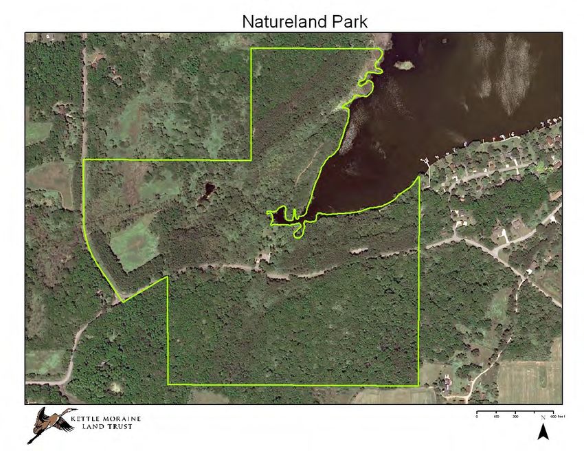
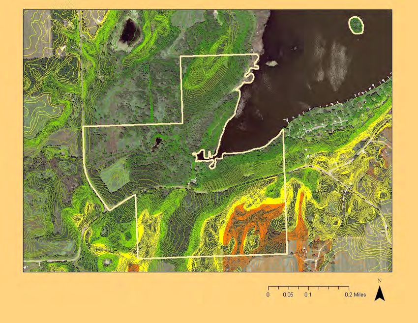
Phase I Plan Introduction                                                          Natureland Topography                                       -      2’ Contours
Natural areas management plans are built on an inven-
tory of information about the site. Understanding the
natural conditions of the land in the past, and how land
use has changed provides insight regarding ecosystems
composition and health. Acknowledging how natural or
human disturbances have changed an ecosystem pro-
vides a guide to repairing or improving the site. Once
basic processes of change are understood and the
property has been inventoried and it’s natural features
and systems evaluated, management units can be devel-
oped that reflect areas of the property that have similar
ecological problems, habitat conditions and end goals
This conceptual natural area restoration plan is a start to
developing more detailed project goals for individual
management units. The plan is meant to germinate dis-
cussion and exchange of information between interested
individuals, professionals, staff and potential volunteers.
As conditions change in the park either due to restoration
and management activities, or natural processes, the
management plan should be adapted to capture specific
management units, restoration and habitat goals and
evaluation strategies to document progress. Remnant
plant ecosystems are usually priority sites for manage-
ment and restoration activities. Often high quality rem-
nant communities are small and receive a great deal of
attention to create conditions for the plants to increase
in abundance. Sometimes with management, overlooked
very small populations of conservative plants can regain
their niche, or even seed of rare plants laying dormant
can germinate in the improved growing conditions.

Topography and Position
The Park is an important feature of northwestern Walworth
County, and its natural shoreline is one of the few remain-
ing expanses of undeveloped shoreline on Whitewater
Lake. The Park’s 166 acres also make up a significant portion of Whitewater Lake’s direct drainage area. The terrain of the park is fundamentally a cradle titled towards the lake. The south side of the
park has significant topographic relief. The highest point in the park is 1007 feet and located south of Territorial Rd. The lowest point is 872 feet down hill from the picnic shelter near the lake.
Natureland Park Soils
Soils
The high ridges and steep slopes in the park are
comprised of gravelly, well drained soils. These soils
are of the Casco-Rodman soil series and are classic
kettle moraine soils found on ridges, eskers and in
kettles. The majority of these soils are on slopes too
steep for cultivation and are generally very dry. The
soils found at the lower elevations of the park are or-
ganic muck soils and occupy the flat poorly drained
areas in former glacial stream outwash valleys. The
loam and silt loams in the valley are on the outwash
plains and stream valleys.

                                                                       A

A   The south bay of Whitewater Lake, Natureland Park
Natureland Park Historic Aerial Photo Comparison
The creation of Whitewater Lake had a significant affect on the lands in the park north of Territorial Road. The lake was first impounded in 1927 to raise the water level to connect three
smaller lakes north of the property. It wasn’t until 1947 that the now larger Whitewater Lake crested 12’ above the original lake level where it remains today. In the 1937 aerial photo
the area that becomes covered with water was marsh and the lands surrounding the marsh were being actively farmed. Most of the tillable land was farmed into the 1950’s. In 1953 the
Walworth County Board acquired the park lands and the plant communities changed through ecological succession to old fields, shrub thickets and small trees. Large scale
manipulation of habitats was accomplished quickly when trees were planted north and south of Territorial Road in areas that were easily accessible and relatively flat. According to A
History of Greater Whitewater Lake & Rice Lakes1, 29,400 white pine, Norway pine, white spruce, white ash and white cedar were planted by 1959. South of Territorial Road on the
steep slopes and ridges, oak and hickory woodlands still grow pretty much undisturbed except for past grazing, since European settlement.

                                           2010                                                                                                     1937

                                                                                     1
                                                                                         History   of Greater Whitewater & Rice Lakes, Greater Whitewater Lakes Property Owner Association, 1997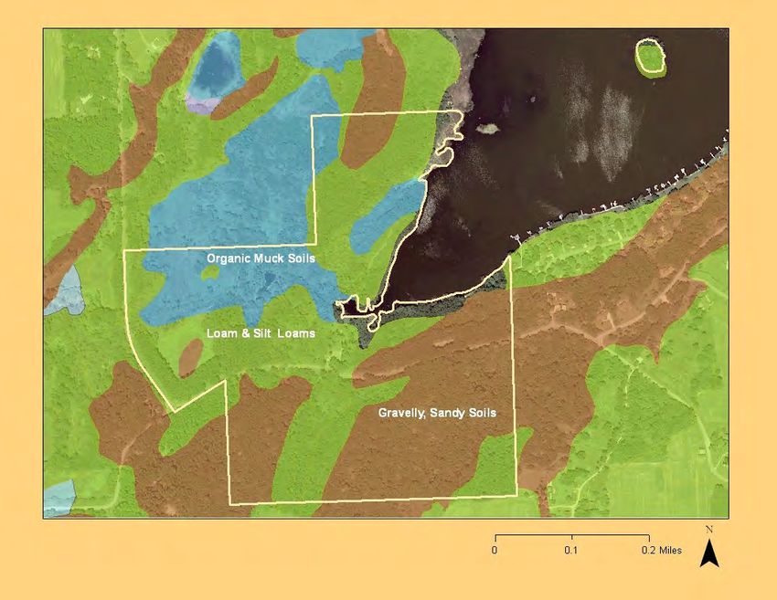
Natureland Photo Points

B   Cedar Log Cabin picnic area

                                                     D            C        B
C   Spring fed stream flowing into Whitewater Lake

D   Prairie Trail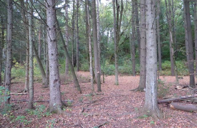
Natureland Park -   Phase I Restoration

    Trail head kiosk south of Territorial Road.
E

                                                                          E

                                                                      F
                                                                               G

    High Wilderness Trail looking south showing
F
    planted pines to the left of the trail, and succes-
    sional woodlands to the right.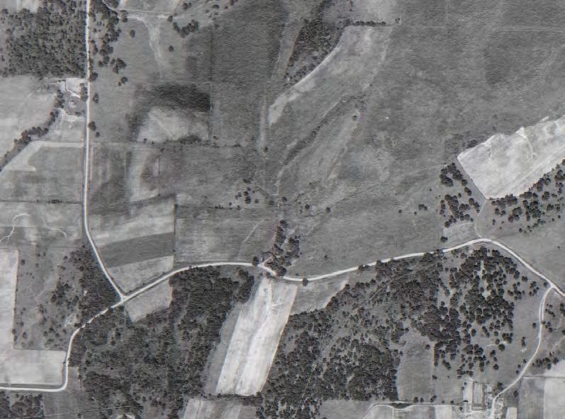
Natureland Park -      Phase I Restoration
Pine Plantings
Most of Natureland Park has been drastically manipulated in the past
150 years. The majority of the north side of the park was farmed until
it was planted to pines or left fallow. The property south of Territorial
Road had one farm field that was likely prairie prior to being farmed,
and now is a pine planting.                                                                                         P
Pine habitat occupies many distinct locations within the Park, and
while pines can provide valuable habitat, the vigor of these trees is
declining. Management of the pine habitat will require a detailed multi
-year approach that should lead to goals for wildlife and recreation
compatible with current and anticipated uses.
Insects, disease and weather events can damage a pine stand and
depending on the age and condition of the trees, these stressors may
have varying long term effects on stand health and structure. Fungal
diseases, moths, weevils and other forest pests are common in pine            P
plantings throughout the state. Determining the current condition of
the various pine stands in the park, and developing a long term
management plan should be done in consultation with County forestry
professionals and regional forestry staff of the Wisconsin DNR to gain
                                                                                                                        P
insight into the most current forest stand management technology and              P        P
harvest guidance.

                                                                                                   P

                                                                                               P   Pine Plantings

                            Pine understory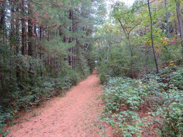
West Lakeshore Habitat
The area along the western shore of Whitewa-
Natureland Park - Phase I Restoration
ter Lake hosts a trail from the picnic area and
parking lot that appears to be a favorite of hikers
and walkers who use the park. Based on site visits and
interviews with park users, the diversity of wildlife includ-
ing birds, amphibians and reptiles seen using the habitat
for feeding, resting and reproduction appears to be high.
Many different types of invasive and native plants grow in
this area. By removing invasive plants and planting
native grasses, forbs and sedges, food resources avail-
able for wildlife will be improved. The quality of water
running off the site will also be enhanced since cur-
rently little or no ground vegetation is trapping sedi-
ment or filtering surface water as it moves down slope to
the lake and wetland. Consideration of turtle nesting re-
quirements and other wildlife resource needs should fac-
tor into the specific clearing project goals and specifica-
tions developed for this important area. Clearing of vege-
tation within 1000 feet of a lake requires a permit from
the Walworth County Land Use & Resource Manage-
ment Department. Staff within this Department should be
consulted for other conservation plan or zoning require-
ments.
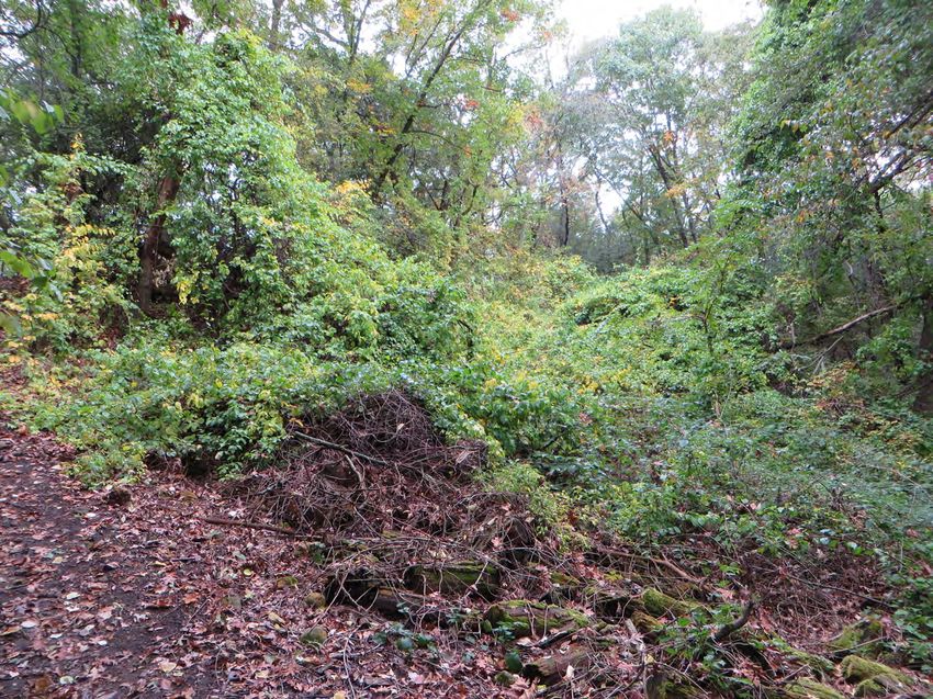
Oriental Bittersweet Control
Current Wisconsin DNR invasive species rule
regulates oriental bittersweet as a prohibited
species that is required to be controlled. One large popu-
lation of oriental bittersweet, a woody vine, was identified
in the park and is estimated to cover approximately 4,000
square feet. It is highly likely that additional populations
exist in the park that should be located and eliminated.
The populations of oriental bittersweet should be identi-
fied in the spring to ensure that no native American
bittersweet is removed. Spring is the best time to verify
the difference in these hard to distinguish plant species.
Their emerging leaf buds provide the best identification
traits. The leaves of oriental bittersweet are tightly folded
against each other, while the leaf buds of the native
American bittersweet are rolled like a scroll.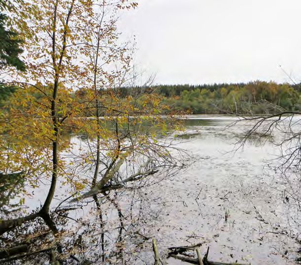
Seed cluster on a female oriental bittersweet vine.

                                                                                                                    Photo Credit: Minnesota Dept. of Agriculture

                                                                                                   Oriental bittersweet vines climb by twining around other plants and
                                                                                                   trees and can grow to be 60’ long. Vines grow in sun or shade and
                                                                                                   can smother trees, alter the structure of a woodlands and eliminate
                                                                                                   entire plant communities.
                                                                                                   Oriental bittersweet reproduces by seed and rhizome. The fruits are
                                                                                                   consumed then dispersed by birds and mammals and ingested
                                                                                                   seeds have a higher germination rate than seeds that fall to the
                                                                                                   ground.
                                                                                                   Combining several methods to remove this plant results in the best
                                                                                                   success rates. Small seedlings can be pulled as long as all the
                                                                                                   roots are removed. Prescribed burning kills young plants and seed-
                                                                                                   lings, but after burn conditions promote germination and spread of
                                                                                                   oriental bittersweet. Herbicide application can also be used on
                                                                                                   either cut stems of the vine or to its leaves at appropriate times of
                                                                                                   the year.
    A sprawling population of invasive oriental bittersweet alongside the High Wilderness Trail.
G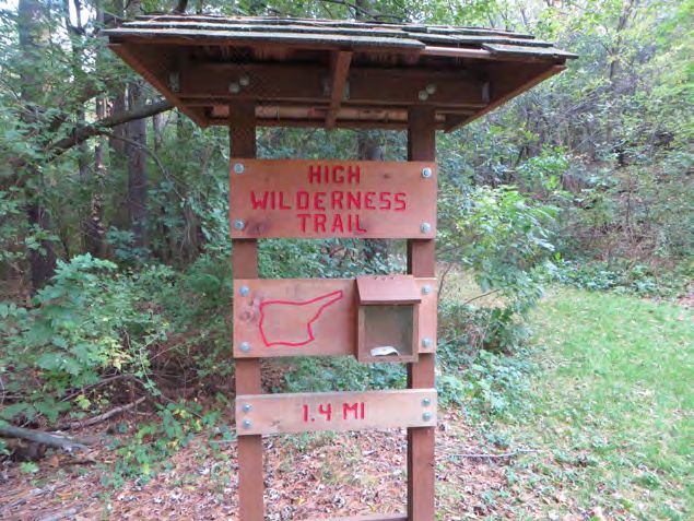
Restoration Tasks - Woody Plant Removal                                                                          Schedule and Project Costs
Undesirable or invasive woody vegetation threaten the health of native woodlands and grasslands. Brush           Utilizing available labor resources from the County Public Works department combined with volunteer groups
clearing and chain saws can be used or if conditions allow, a tracked skid steer with a mower or grapple         will create a win-win situation for all. Woodland restoration work can proceed quite rapidly during winter months
attachment is useful. The primary advantage is lower ground pressure and stable operation over uneven            using crews of 3-6 people to systematically identify species, and cut and herbicide undesirable trees and shrubs.
surfaces. Woody debris can be disposed of by chipping or piling and burning the brush. Brush pile loca-          Disposal of woody debris is dependent on species, quantity and in certain conditions lakeshore habitat require-
tions are determined prior to cutting and located to avoid impacts to desirable trees and vegetation. Wild-      ments.
life habitat can be created by piling brush along wetland edges or strategically near or along the lakeshore.
                                                                                                                 Proper planning and execution of woodland clearing and seeding projects is dictated by timing, available labor
Basal Bark Application                                                                                           and equipment, and desired future conditions. As these elements are determined in cooperation with the
                                                                                                                 County Public Works staff, definitive timelines and project estimates can be created.
Basal bark application can be done in the fall or winter after foliage is gone to avoid foliage brown-out in
high visibility areas. Basal bark applications controls trees and brush that are less than six inches in
diameter but too large for backpack foliar applications. This method also reduces the impact on surround-
ing desirable plants. Fall and winter applications provide the best access for treatment due to the lack of
existing foliage.

Cut Surface Treatments                                                                                           Funding Sources - Grants

Cut surface treatments involve cutting the tree or shrub close to the ground and applying an appropriate         WDNR: Healthy Lakes Grant                                   Recreational Trails Act
herbicide. Cut surface treatments may be made any time of the year except spring, as long as the herbi-                                                                      Grant award up to $45,000, 50% match required, can be in-
                                                                                                                                                                             kind. Funding for improving existing trails and some near
cide does not freeze when applied, and the tree is not frozen. Avoid cutting followed by herbicide applica-      Heidi Bunk
                                                                                                                                                                             trail habitat improvements.
tion during heavy sap flow since this can interfere with translocation. Heavy sap flow can also carry the        141 NW Barstow St., Rm. 180,
herbicide mixture off the stump resulting in poor control. Invasive honeysuckle should be treated with gly-      Waukesha, WI 53188
                                                                                                                                                                             Jim Ritchie, WDNR
phosate and most other woody invasives are controlled with a triclopyr formulation. Carefully follow all la-     262-574-2130 (ph) 262-574-2128 (fax)
                                                                                                                 Heidi.Bunk@wisconsin.gov                                    2300 N. Dr. Martin Luther King Jr. Drive,
bel directions and avoid off target impacts
                                                                                                                                                                             Milwaukee, WI 53212-3128.
                                                                                                                                                                             phone (414) 263-8610,
Fall Foliar Spray
                                                                                                                 Grant award capped at $25,000 and requires a 75/25 state/   e-mail: Jim.Ritchie@Wisconsin.gov.
                                                                                                                 sponsor match. Appropriate practices that could be funded
After native vegetation has ceased photosynthesizing, buckthorn can be treated with a foliar application of      under this grant include 350 square foot native planting
glyphosate. A backpack sprayer is normally used to systematically canvas and treat an area.                      plots and diversion practices to improve habitat and slow
                                                                                                                 runoff along the lakeshore. Each practice is capped at
Mechanical Removal                                                                                               $1,000 maximum. Grants run for a 2-year time period. Ap-
                                                                                                                 plication deadline is February 1.
A track skid-steer and front-mounted grapple can be helpful to move brush into piles efficiently. Skid-
                                                                                                                                                                             Potential Community Partners
steers should only be use when the ground is frozen to avoid ground disturbance.                                 U.S. Fish & Wildlife: Partners for Fish and Wildlife
                                                                                                                 Grant amounts vary and projects are developed in            Ice Age Trail Alliance
                                                                                                                 partnership.                                                Walworth/Jefferson Chapter
Prescribed Burns and Woodland Seeding
                                                                                                                                                                             Andy Whitney
After an area is cleared it a prescribed burn plan should be prepared and implemented by trained person-         Kurt Waterstradt                                            262-949-0286
nel. Seeding or planting with native species in select locations where follow-up and monitoring can be car-      U.S. Fish & Wildlife Service                                andywhitney1@yahoo.com
ried out, should soon follow. Continued vigilance of invasive species presence and control will always be        4511 Helgensen Drive                                        wwi.iceagetrail.org
an annual maintenance task.                                                                                      Madison, WI 53718-6747
                                                                                                                 608-221-1206 (x14)                                          Whitewater Community Foundation
                                                                                                                 FAX: 608-221-1357
Oriental Bittersweet Removal                                                                                     Email: Kurt_Waterstradt@fws.gov                             Brienne Brown, Exec. Director
                                                                                                                                                                             briennedieboldtbrown@gmail.com
Populations of oriental bittersweet should be identified and recorded with global positioning equipment in       WDNR: County Conservation Aid                               512-297-8928
order to more easily locate, treat and evaluate the control effort in subsequent years. Public work staff, or    Grant amounts yearly to each county, normally around
trained contractors are best suited to eliminate this plant through a combination of cutting, herbicide appli-   $1,500 but must request. Unrequested funds get distrib-     Lakeview Elementary School
cation and possibly hand pulling.                                                                                uted within the southeast region.                           Mr. David Brokopp, Principal
                                                                                                                                                                             W8363 R&W Townline Road
                                                                                                                                                                             Whitewater, WI 53190
Natureland Park Initial Natural Areas Management Plan 2015-2018
Volun-
Year 1 Year 2 Year 3 teer / Partner
Group Assis-
Task Spring Summer Fall Winter Spring Summer Fall Winter Spring Summer Fall Winter Project tance Management Unit Designation and Notes
FFA,
Yes Scout
Woody Plant Removal - Hand Clearing Groups Western Lakeshore Habitat
Woody Plant Removal - Mechanical
Clearing Western Lakeshore Habitat
Fall Foliar Herbicide Treatment of Inva- Western Lakeshore Habitat and oriental bittersweet
sive Species populations.
FFA,
Invasive Forb Removal - Hand Pulling Yes Scout
or Hand Held Herbicide Applicators Groups Throughout the park.
Bittersweet locations could be marked by students,
FFA, and identification of species verified by staff or con-
Possibly Scout sultants. Removal and treatment could be done by
Oriental Bittersweet Identification & Groups various groups depending on their capabilities and
Control time of year.
Wild
Yes Ones,
Forb & Grass Plantings FFA Western Lakeshore Habitat
Fire
Wood- Wood-
Prairie
lands lands
Depts.,
Prescribed Burns WDNR Prairie
Pine Habitat-Restoration Plan Devel- WDNR Develop a long term management plan in cooperation
opment & Implementation with forestry professionals.
Plant Inventory
Audu- Citizen science program is Wisconsin Ebird, http://
Yes
Bird Survey bon ebird.org/content/wi/
Yes North American Amphibian Monitoring Program,
Amphibian & Toad Survey https://www.pwrc.usgs.gov/naamp/index.cfm?
Springs and seeps appear to be in fairly stable bank
Trout
condition. The lake shoreline northwest of the picnic
Yes Unlim-
area should be assessed for lakeshore habitat plant-
ited
Streambank & Shoreline Restorations ings.
Natural areas management plans are updated periodically to reflect the changing conditions and improvements of the site. Additional information gained from plant and animal surveys will help set more specific goals for the
park, and as new labor and financial resources become available the plan should be updated. Sustainable, healthy ecosystems are less costly to manage and provide greater benefit to the community. Initially costs to re-
move invasive species and restore an ecosystem to a more self-sustaining state are high, but these costs should decrease as less intensive efforts are required in future years. Although it’s not noted in the above schedule,
investing in education and outreach including park signs that explain the restoration activities, and informing county residents about the purpose of the plan are crucially important.Board of Directors Program Manager
President Maggie Zoellner
Jerry Petersen
Vice-President
Jim Blomberg
www.kmlandtrust.org
Secretary
P.O. Box 176
Herb Sharpless
Elkhorn, WI 53121
Treasurer
262-949-7211
Bill Huxhold
Sue Heffron
Don Henderson
Tom Herbstritt
Ken Ingle
Walker Johnson
Steve Klitzing
Gerry Petersen
Dave WeinerYou can also read