CONTENTS WINTER, 2020/2021 - www.vi-trail.ca - the vancouver island trail
←
→
Page content transcription
If your browser does not render page correctly, please read the page content below
www.vi-trail.ca

                                              WINTER, 2020/2021

                                                      CONTENTS
                                       Two More Hikers Traverse The Trail
                                        Focus on a VITA Board Member
                                         Trail Work Summer/Fall 2020
                                           Sightings Along The Trail
                                            Want to Get Involved?

    A COUPLE OF EXPERIENCED LONG-                            mapped route. That was just part of the adventure and
                                                             part of the specialness of this hike, to be a part of the
 DISTANCE THRU HIKERS TRAVERSED THE                          trail as it continues to grow and take a defined shape.
       TRAIL THIS PAST SUMMER
      Here is Their (Shortened) Documentary                  Coming out of Victoria, we were able to hold a steady
                                                             pace, taking two days to get to Cowichan Lake. The trail
The year of 2020 was an interesting hiking season for        conditions were excellent. Most of the trail was gravel
my partner and me. We had our plans dialed in to the         bike paths, with some great views along the way.
day to fit in all the thru-hikes we could do into our
schedule. Then everything changed (COVID-19), and
instead of being discouraged, we changed with it.

My partner and I go by the trail names Constantine and
Magpie, respectively. We are both long-distance thru-
hikers and backpackers.

In our research, we stumbled upon the Vancouver
Island Trail (About 770km). We said perfect! Let’s go!

We began our hike on August 9th, 2020. We quickly
came to realize that despite all our hiking experience,      We got our first taste of what was to come while
the VIT was an adventure unto itself. The trail              leaving Cowichan Lake. The maps had us taking a
association had provided maps and GPX files that we          remote logging road over a mountain, but luckily, we
could base our route on, yet much was still a work in        found out while in town that the area was privately
progress. It’s a beautiful trail with much love around it,
but just as much love is needed for it to become a fully             Vancouver Island Trail Association Page 1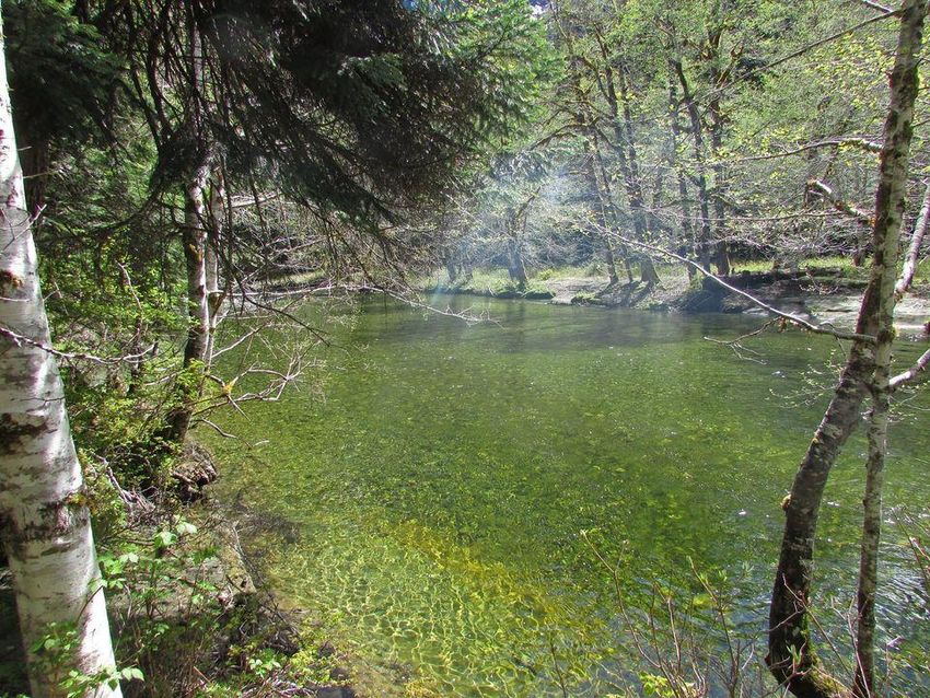
owned and that access was tightly restricted. The GPX       it finally did clear, the alpine travel rewarded us with
route shown on our maps was the proposed route, and         views of the surrounding mountains, fresh air and clean
would be hikable once all land deals were negotiated.       water. This led us to the section from Strathcona Dam
So we continued out of Cowichan Lake on the highway,        to Woss. The maps for this leg were mostly reliable, but
staying as close to the route as we could. Navigating up    it appears that the VIT has re-routed the trail since they
towards Port Alberni, we got back on single-track trail     were drawn. We decided to follow the trail signs as they
via the Alberni Inlet Trail and The Runner’s Trail, which   diverged from the map, and ended up very far away
took us all the way into town. This piece of trail system   from the GPX route on the website. We had come to
was beautifully maintained for the most part, with a few    realize this was part of the navigation on the VIT -
sections that were steep and brushy along the cliff faces   ground-truth it as you go. Due to extra switchbacks and
near the water. Old railroad beds and the sound of the      road crossings on the new trail, this section was
ocean were our neighbors.                                   significantly longer than advertised, but also
                                                            significantly more special, because we were brought
The route from Port Alberni to the town of Cumberland       deeper into the mountain range.
was quite another experience. This brought us deep
into the Beaufort Range, a wondrous mountain range          We met the kindest couple that we’ve met in a long
with views of the ocean and rugged peaks to traverse.       time in the town of Woss. They did not know exactly
The views were abundant, but so was the route finding.      what we were doing, since this trail is still so new, but
Trail would peter out and then be lost altogether,          they knew extreme amounts of kindness. They knew we
especially when traversing between peaks. Flagging          were running out of battery to document this trail, and
tape would every so often call us in the right direction,   let us charge up our devices and even let us stay with
but good navigation skills were necessary, as there was     them! Amazing people always seem to find their way to
frequently no clear path to follow. The heavy vegetation    these trails.
and steep terrain would demand slower miles each day,
but also reward us with grander views. The GPX files        Once we arrived in Port McNeil, we needed a break.
were more recommendations than legit trail to follow,       Our bodies and minds needed a reset to tackle the last
and we were occasionally misled by old flagging tape        part of the trail. Following a day of rest in Port McNeil,
left by loggers or peak-baggers past. Eventually the
route cut across impassable cliff faces and a re-route
became necessary, so we picked our way down steep
and densely forested slopes to an active logging road.
There’s only sporadic trail throughout this section, but
amazing hiking.

                                                            rejuvenated, we hiked on, eager to finish this thru-hike.
                                                            The trail system from Port McNeil to Port Hardy took us
                                                            a day, and within that day we were bluff-charged by
                                                            three mama bears protecting their cubs, and saw five
                                                            more bears from a distance. A lot of the trail was
                                                            coastline walking, intermixed with dense forest once
                                                            again. It was beautiful.

Cumberland to Port McNeil was by far one of my              Coming out of Port Hardy, we had to hike roughly 50km
favorite sections. The Forbidden Plateau out of             to join the North Coast Trail, and then the North Coast
Cumberland was spectacular. We got caught in a three-       Trail itself. We had committed ourselves to connecting
day rainstorm and had to take shelter in the tent for a
full day, as the water was just a wall, impassable. When            Vancouver Island Trail Association Page 2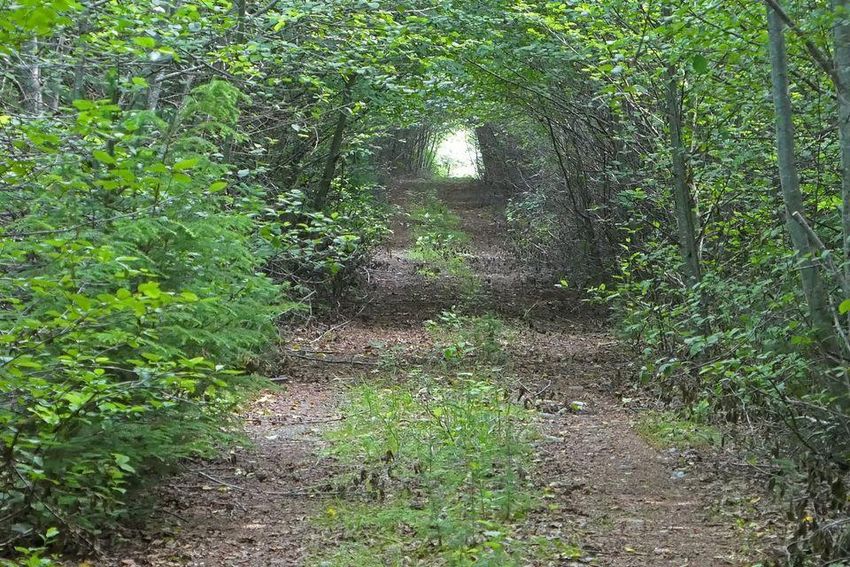
every footstep, as a continuous footpath is our                the next grand view on top of a peak. We came to love
definition of a true thru-hike. So, no water taxi for us!      this trail for what it was. It had much and lacked even
Instead, we had a gravel road walk to a thick bushwhack        more, but as an infant trail that is just starting to use its
to meet the beginning of the NCT. The last kilometer           legs, we were happy to provide our legs to help it find
and a half or so took us the better part of two hours,         its own. We are excited to see how it continues to
the vegetation was that dense.                                 define itself and grow as more people become a part of
                                                               it!
Once on the North Coast Trail, mud became our
constant companion. We made a game out of it to stay           Big thanks to Ryan Bunting for the above article. You
sane. We joke, but it was a really beautiful part of the       can see his complete article HERE!
trail, just extremely rugged. We completed the entirety
of the North Coast Trail in 31 or 32 hours, starting at        And follow Ryan’s various “Journeys” HERE!
11am at the Eastern Terminus one day and ending at
the Western Terminus at 6pm the next. All we had to do
was go touch the Cape Scott lighthouse. Our last night            WE CONTINUE OUR FOCUS ON ONE OF
on trail, we camped at Nels Bight, only a few kilometers               VITA’s BOARD MEMBERS:
away from the Northern Terminus of the VIT. As we                           Doug Goodman
stripped out of our muddy, sandy, and torn-apart gear
for the last time, we exclaimed to each other how much

of a journey it had been. Who knew that on Vancouver           Doug has been wandering along trails and through the
Island, there was a trail that would traverse the entire       bush since he learned to walk. Before moving to
length, and bring you through such diverse and                 Victoria in 1972 at the age of 14, he explored scrub,
spectacular wilderness? As the lighthouse came into            meadows, ravines and forests in Africa, Germany, and
view the next morning, my partner and I touched the            four provinces of Canada. While in Victoria Doug spent
structure together, finishing this hike as we started it, a    12 years studying mathematics and biology at the
team.                                                          University of Victoria, eventually specializing in forestry
                                                               biology and working for the Canadian Forest Service.
We finished on September 4th, 2020. It had taken us 27         Doug was an active expedition leader with the Victoria
days. Out of the 27 days, seven of them were what we           Group of the Sierra Club in the 1970’s and with the
call Zero days in town. We had set out expecting this trail    Vancouver Island Section of the Alpine Club in the
to take us only two weeks, but due to navigation               1990’s. After a move to Port Hardy in 2001 to be a
challenges on the ground, we chose to enjoy this               teacher, his passion for mountain biking led him to build
journey instead of running out the clock, and we sat           and maintain many kilometers of trails near Port Hardy
back and relaxed into our pace. I’m really glad this was       and Port McNeill. Since 2005, Doug has worked as a
the approach we took. With this trail as it currently is, it   forest engineer, planning logging roads and cutblocks
is meant to be enjoyed by each day and each moment.            on the north island and mainland mid-coast. He now
You are going to run into different obstacles each day,        lives in Sointula, surrounded by trees and birds.
whether that is a re-route as the trail continues to grow
and become more defined, or a bushwhack to arrive at                   Vancouver Island Trail Association Page 3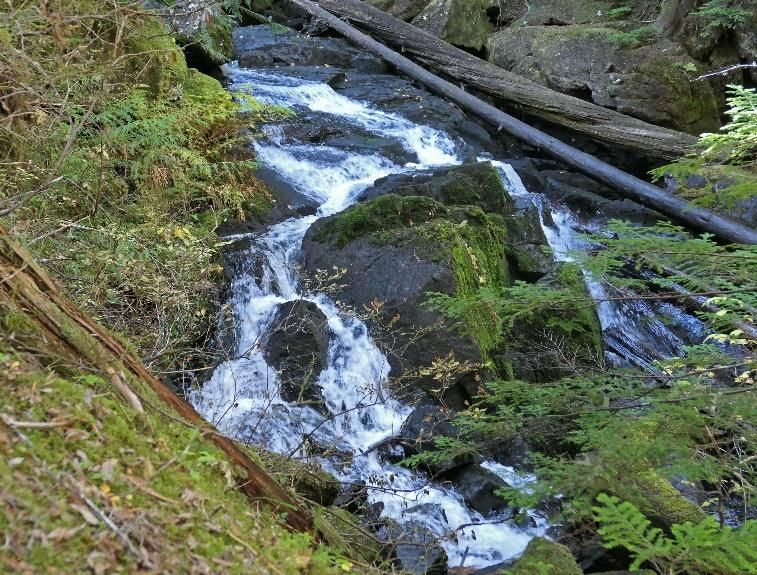
UPDATE ON THE GREAT VOLUNTEER The bulk of the work followed behind snowmelt in mid-
June, starting near Mt. Irwin. We worked mostly from
WORK IN THE BEAUFORTS DURING 2020 south to north – Mt. Irwin to Hal to Joan to Apps to
Cameron to Henry Spencer. We then skipped a section
The main focus on trail work during the summer and fall on the well-defined rocky ridge above Beaufort Lake
of 2020 was on the trail over the Beaufort Range and looked at a couple of alternate routes between
between Port Alberni and Cumberland. This involved Tsable Mtn. and Mt. Clifton. Unfortunately, the shorter
almost 1,000 hours (991) of volunteer work. The work days and periodic snowfall have brought this to a halt
crew on many days was 5 or more; on one day we had a for this year, leaving only 5 km or so to finish up in
crew of 11! The crews included several new volunteers 2021.
who had learned of the VI Trail via Facebook, our
webpage or by word of mouth – VITA is hugely thankful Earlier in the summer, we had already done some
for their contributions. maintenance and additional clearing and marking
between Mt. Clifton and the mountain bike trails that
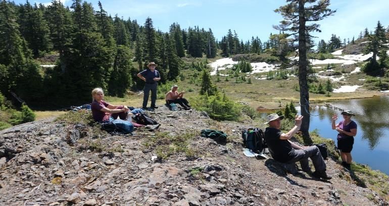
Volunteer Team Lunch lead into Cumberland, including trail to and around
Tsable Lake.
Dedicated Volunteer Trail Workers
The main objective was to locate, mark and map the
route. Trail marking is especially important to improve
hiker safety during the poor visibility that often plagues
the Beaufort crest during fog and low cloud conditions –
conditions not just associated with poor weather
generally but also quite common when lower elevations
are in sunshine. As is common everywhere, mountains Overall, we found much of the route along the Beaufort
make their own weather. crest to be reasonably well established, particularly the
sections south of Mt. Apps within forest where a well-
We used the usual VIT trail markers, the fluorescent defined trail tread was the norm. Here, maintenance
orange, 2” square aluminum tags screwed into trees. and upgrading involved sporadic clearing of brush and
As much as possible we removed old flagging tape that only rarely the cutting out of windfalls. In contrast,
invariably ends up on the ground as trail garbage. We once into the semi-open mountain hemlock parkland,
use screws rather than nails so that the screws can be the trail ranged from poorly defined tread to non-
easily backed-out as the trees grow. If/when nails existent. In these sections, there are often multiple
grow-in, pulling them out a bit or removing them can be feasible routes; presumably past hikers have spread out
difficult and often results in damage to the tree. to find their own way so that no specific route has been
defined. This is fine in good weather, but in the past
VITA Trail Marker has been difficult to navigate for many hikers during
poor visibility with clouds right down to the ground
(most notably on the broad plateau-like ridge south of
Apps). Consequently, we focused on trail marking in
these sections with some sporadic brushing most often
in the transition from the parkland into patches of
Vancouver Island Trail Association Page 4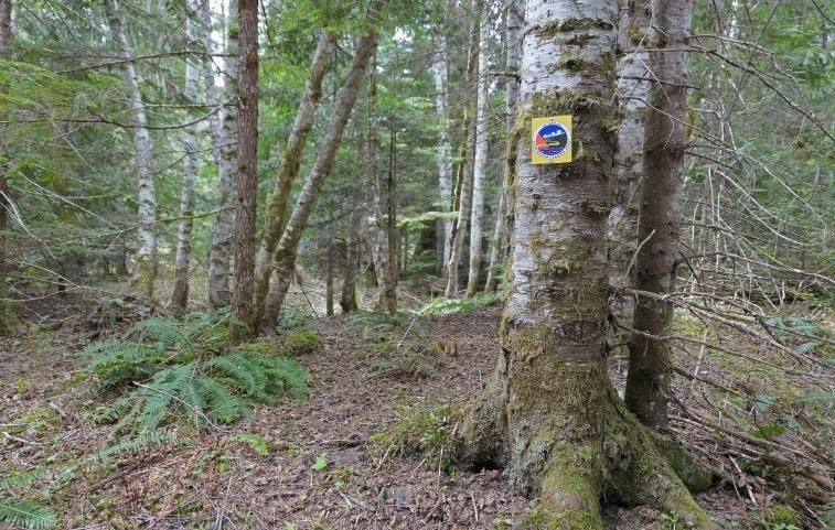
forest. North of Apps, forested sections of the steeper      We Once Again Offer Some Examples of
slopes often required quite a bit of brushing, especially
the thick copperbush of forest openings that is annually
                                                             Sights You Will Experience Along the VI
appressed to the ground by snowpack.                                      Trail - Enjoy!

      Penstemon heterophyllus – Mount Joan                      Upper Valley Kokummi Mountain Area

The Beauforts (i.e. “beautiful and strong”) are indeed
beautiful and yes challenging to hike because of the               VI Trail Sign – Grilse Grove Area
numerous steep-sided draws and cliff bands that seem
to be invariably oriented across the path of the hiker. In
spite of the effort required, the trail crews enjoyed
many spectacular Beaufort hikes this past summer –
hopefully the included images will give a sense of that.

                  View From Mt Joan

                                                                      Falls By John Fraser Lake

(Editors note: Big thanks to Terry Lewis, VITA’s Director
of Operations for Championing this development work
in the Beauforts and submitting this update!!)

                                                                 Vancouver Island Trail Association Page 5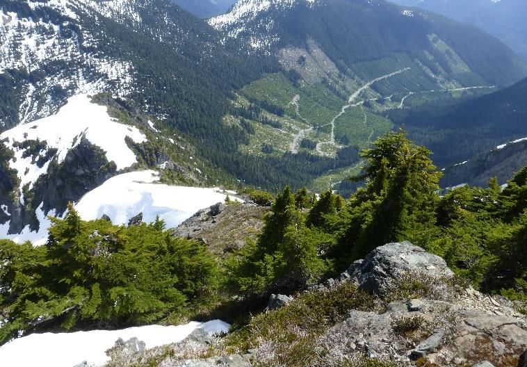
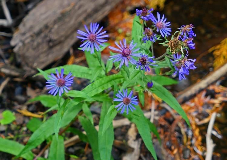
Aster Conspicuous – John Fraser Lake Area Sunrise Lake Looking Down From Jutland Ridge
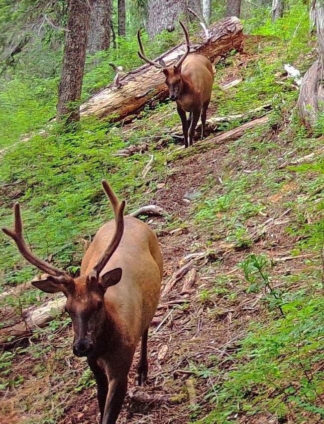
Elk Along Kokummi Suquash Main “Tunnel”
The Ever Clear White River
Vancouver Island Trail Association Page 6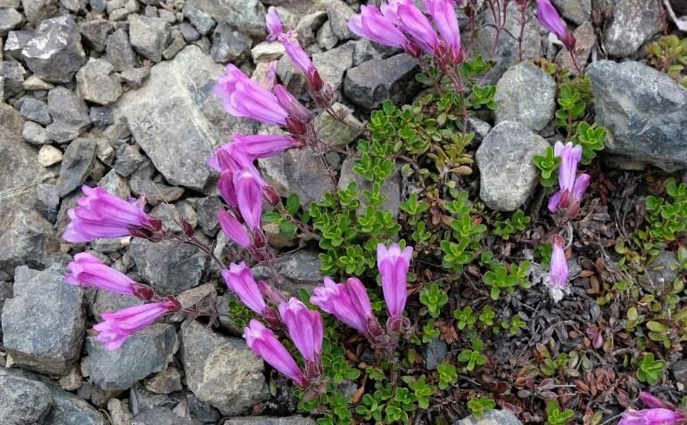
As Always - An Important Reminder To “Be Safe”!!:
    “VITA wishes to remind and warn all those considering visiting the VI Trail that the Trail is a “Work in
   Progress” and that certain portions have yet to be completed, and in some instances may not even be
  accessible. Travel on the planned Trail is completely at the risk of the individual doing so. Please realize
   that some sections of the VI Trail are through unpopulated areas where users must be self-reliant with
  respect to maps and the use of directional equipment, and where wild animals may pose a risk to some
                                              types of activities."

                      VITA’S Vision For a Homegrown Adventure:
 A signature recreation destination in Canada, the Vancouver Island Trail will span more than 770 km from
  Victoria to Cape Scott. Traversing both ancient and working forests, and wild coasts, while joining island
communities, the Trail in its entirety will be a 2-3 month-long journey. Not just for long distance hikers, day
hikers will enjoy many access points. By 2021, Vancouver Island will have a unique recreational opportunity
    and a showcase for its communities, including highlighting First Nation’s Art, Culture, Language, and
                                                     History.

                                      We hope you will visit our website

                    Interested in our map of the VI Trail and links to the various sections?

                  Once again, your feedback and offered input is encouraged and valued –
                          Please feel free to contact the Editor, Scott Henley, at:
                                        IslandHikerGuy@GMail.Com

                                      Want to Get Involved?
              There are two main ways to help VITA complete the VI Trail:

                                If you wish to become a Volunteer

          If you don’t have any spare time, become a “Friend of the VI Trail”
                   And help us Out with a tax deductible Donation

                     As Well – Follow Our VITA Volunteers on Facebook

                                                                   Vancouver Island Trail Association Page 7
You can also read