Cook Islands CONVENTION ON BIOLOGICAL DIVERSITY - 5TH NATIONAL REPORT TO
←
→
Page content transcription
If your browser does not render page correctly, please read the page content below
Cook Islands
    5TH NATIONAL REPORT TO THE
CONVENTION ON BIOLOGICAL DIVERSITY

              2017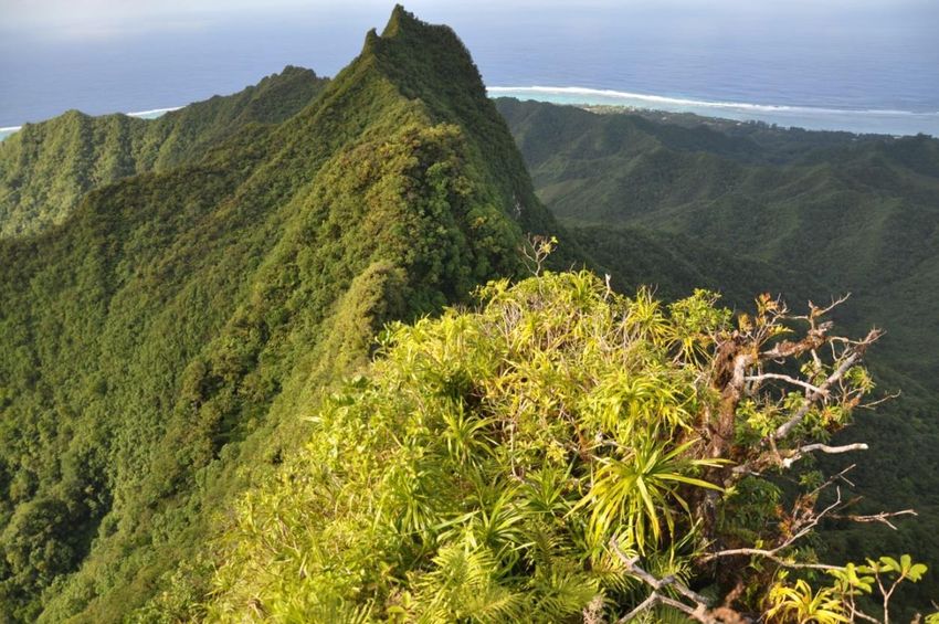
Acknowledgements

The National Environment Service would like to gratefully express our gratitude to the NES staff,
National Biodiversity Steering Committee, those individuals, experts, institutions and community
groups who kindly gave valuable assistance, information and comments during the compilation
of this report.

Approved by the Cabinet of the Cook Islands Government on the 16th November, 2018
CM(17) 0435

This report was prepared by Dr David Butler.

Cover photo of ‘Kakerori’ mural created by Charles and Janine Williams with Numangatini
Mackenzie, National Environment Service office, Rarotonga, Cook Islands.

Prepared for the National Environment Service © 2017

Funded by the GEF/UNDP National Biodiversity Planning to Support the implementation of the
CBD 2011-2020 Strategic Plan in the Cook Islands Project.

                                                                                               2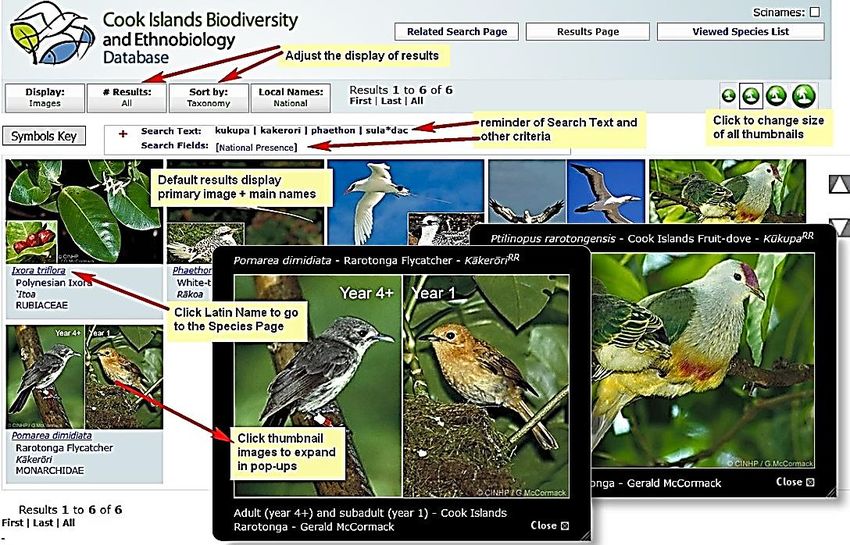
Foreword

Kia Orana,

Te mataora nei matou i te oronga atu i teia ripoti a te Kuku Airani no runga i te Ao Ora Natura. Ko te
rua o te ripoti teia a te Kuki Airani no runga i te turanga tana i rave i raro ake i te Koreromotu o te
Ao Ora Natura.

Na roto i te āriki’anga i teia Koreromotu, kua papa’u tatou kia paruru e kia taporoporo’ia te Ao Ora
Natura o te Kuki Airani. Kia ngakauparau tatou i te turanga ta tatou e rave nei ei akamatutu i to
tatou Ao Ora Natura na roto i ta tatou peu maori, te kimi puapinga e pera katoa to tatou tu rangatira
te iti Tangata Kuki Airani.

Ko tei raveia mai na i roto i te ripoti mua i te paruru i to tatou Ao Ora Natura, kua riro teia ripoti i te
akako’u i te turanga matutu ta tatou i rave no te taporoporo e te paruru’anga i to tatou Ao Ora
Natura te au Mariko Ao Ora no te uki ka aru mai.

Kia riro teia ripoti ei ‘akairo i te turanga rangatira i ta tatou i papa’u no te paruru’anga i te Ao Ora
Natura o te Kuki Airani e tuatau uatu.

It is with great pleasure the Cook Islands submits the 5th National Report to the Convention on
Biological Diversity, the second report of its kind produced by the Cook Islands.

As a party to the Convention on Biological Diversity, biodiversity conservation is an important
component of our national sustainable development agenda given our close ties between
biodiversity and our culture, livelihoods and heritage.

The Cook Islands first national report presented an in-depth review of the actions and activities
carried out with a particular focus on threats to biodiversity and key projects that were implemented
successfully. Many of these threats and projects are ongoing and this second report provides an
update of the significant progress that has been made on recovery work on several threatened
endemic species and on management work to eradicate or control invasive species.

It is through this report that we share our experiences in addressing biodiversity loss and
conservation and reaffirm the commitment of the Cook Islands to the Convention on Biological
Diversity.

                                                                                                         3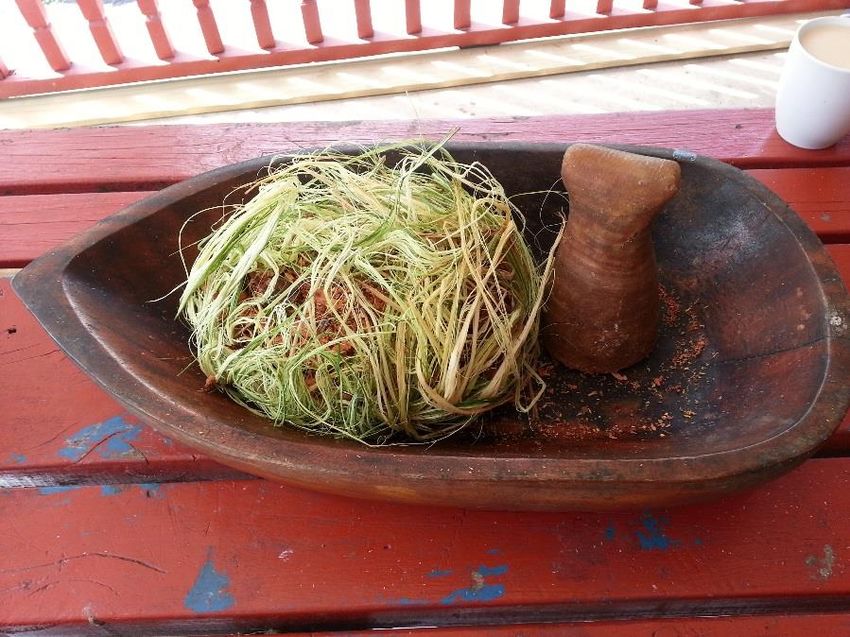
Contents
Foreword ......................................................................................................................................................2
Executive Summary ......................................................................................................................................5
Chapter 1: Overview and update of Biodiversity Status, Trends and Threats ..............................................7
   1.1 Importance of biodiversity to the Cook Islands..................................................................................7
   1.2 Status and trends of Biodiversity in the Cook Islands ........................................................................8
       1.2.1 Geography ...................................................................................................................................8
       1.2.2 Introduction to species and habitat diversity ............................................................................10
       1.2.3. Updated information on species and habitats since 4th National Report ................................14
       1.2.4. Protected Areas ........................................................................................................................25
   1.3 Threats to biodiversity ......................................................................................................................29
       1.3.1 Invasive species .........................................................................................................................29
       1.3.2 Overharvesting ..........................................................................................................................34
       1.3.3 Habitat loss and deterioration...................................................................................................34
       1.3.4 Climate Change ..........................................................................................................................35
Chapter 2: National Biodiversity Strategy & Action Plan (NBSAP), its implementation and mainstreaming
of biodiversity. ............................................................................................................................................38
Chapter 3: Progress towards 2015 and 2020 Aichi Biodiversity Targets and contributions to 2015 Targets
of the Millennium Development Goals. .....................................................................................................47
   3.1 2015 & 2020 Aichi Biodiversity Targets ............................................................................................47
   3.2 2015 Targets of the Millennium Development Goals (MDG) ...........................................................52
   3.3 Lessons learned from the implementation of the Convention in Cook Islands ...............................53
   References ..............................................................................................................................................55

                                                                                                                                                              4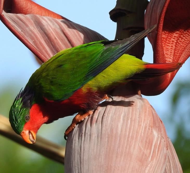
Executive Summary

In the five years since the Cook Islands produced a comprehensive 4th National Report, the country’s
terrestrial and marine ecosystems remain in generally good condition, and face limited human-induced
threats as many islands undergo reductions in population and continuing reduction in agricultural activity.
Significant progress has been made on recovery work on several threatened endemic species and on
management work to eradicate or control invasive species.

On land, 62% of the country remains covered in native forest whose quality is rated ‘good to fair’. The
Cook Islands has a limited range of wetlands. Freshwater streams on Rarotonga show a deteriorating
trend in water quality from 2006-12 and they also are of ‘poor’ quality on Aitutaki. Measures aiming to
address this included a community-based Catchment Management Plan and programmes to upgrade
septic tank systems.

In the marine environment, there is a positive trend of increased coral cover nationally following a
previous outbreak of crown-of-thorns starfish and bleaching events. Surveys of reef invertebrates and
finfish show fluctuations relating to decadal climate cycles and very limited indications of over-harvesting.

Regarding terrestrial threatened species and ecosystems, a survey of cloud forests on Rarotonga
confirmed the presence of nine endemic endangered plants and identified key issues requiring
management, particularly invasive species. A programme to conserve plants used for traditional medicine
(Vairakau Maori) has developed an action plan following surveys and consultations. Actions from these
activities will be included in a revised NBSAP under development. Recovery work has continued to
increase the numbers of two endangered birds, the Rarotongan Monarch (Kakerori) and Rimatara
Lorikeet (Kura), and surveys been undertaken for the Rarotongan Starling (I’oi) and the Atiu Swiftlet
(Kopeka).

Surveys have been conducted of species that use both marine and terrestrial environments. The
population of coconut crabs (‘Unga) on Mauke showed signs of overharvesting and a ra’ui (locally
managed conservation area) has been put in place over a significant area of forest. Surveys conducted
by NGO’s are building up a comprehensive picture of green turtle nesting nationally.

Invasive species have received significant attention through a regional GEF/UNEP programme
coordinated by SPREP including the development of a national strategy. Rats were eradicated from most
of the motu (islets) on Suwarrow National Park and a biosecurity plan developed, and myna eradicated
from Atiu. Communities tackled weeds on several islands and a major biocontrol programme continues.
Climbing vines remain a major threat to some forest areas.

A declining population on the outer islands means that there is limited pressure on natural resources
there and little evidence of overharvesting of reef invertebrates and fish. However some stocks,
particularly giant clams, require management to recover from past over-exploitation. There are also no
major problems on Rarotonga as the presence of the disease Ciguatera has reduced the eating of reef
fish. A network of small ra’ui on Rarotonga shows variable effectiveness at conserving local marine
resources and needs some expansion and tightening of management.

                                                                                                           5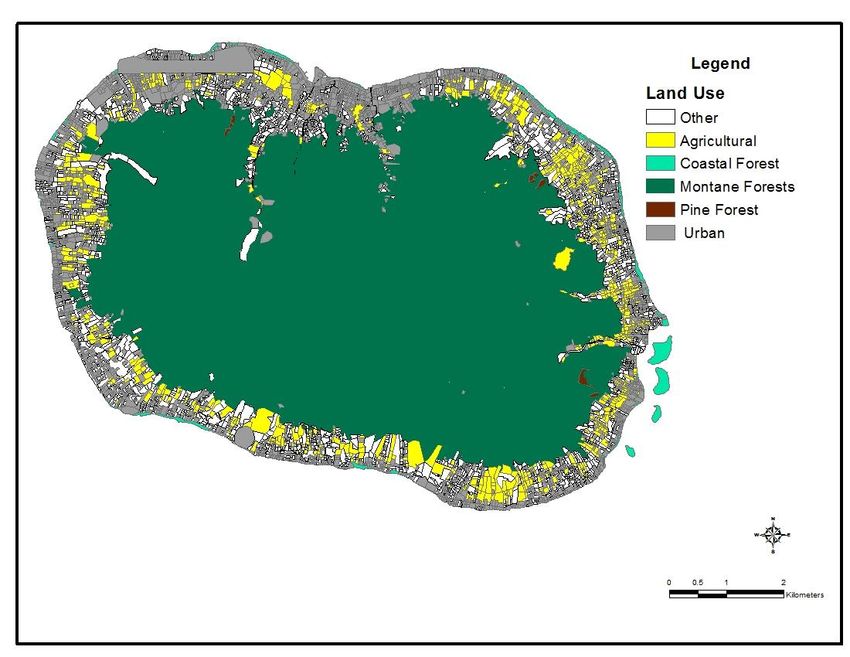
In 2012 the Cook Islands created a shark sanctuary within its waters. The development of a policy
framework for a whale sanctuary declared in 2001 is underway. A multiple-use Marine Park – Marae
Moana was created in 2017, also covering the country’s entire marine jurisdiction, an area of 1.9 million
square kilometres. Within the Park 324,000 sq. km has been earmarked for a higher level of protection
with its purpose "to protect the pelagic, benthic, coral reef, coastal, and lagoon habitats of the Marae
Moana and, accordingly, all seabed minerals activities and large-scale commercial fishing in the area are
prohibited, but other ecologically sustainable uses are permitted".

There is evidence of the impacts of climate change including ocean acidification, coral bleaching and salt
water intrusion. The country has completed its second Joint National Action Plan for Disaster Risk
Management and Climate Change (JNAP) 2016-2020 to address threats and increase resilience.

The Country’s first NBSAP was developed in 2001 and contained eight themes with a broad series of
actions. Work has progressed within each theme though the NBSAP was not a major driver of this. The
NBSAP was also developed before quantifiable targets and indicators were in wide use so assessing
progress against Aichi Targets and Millennium Development Goals is problematic. The revised NBSAP will
be more prescriptive to identify the priority actions needed, with associated targets and means of
verification.

                                                                                                        6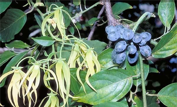
Chapter 1: Overview and update of Biodiversity Status, Trends and Threats

1.1 Importance of biodiversity to the Cook Islands

The country’s biodiversity is vital to its future. The primary sector (Agriculture, Fishing and Pearl
Industries) made up 5.7% of Gross Domestic Product (GDP) in 2012 (Ministry of Finance and Economic
Management, National Accounts). That year there was a 9.3% increasing in the Fishing and Pearl Industry
and a continuing decline trend in the contribution from agriculture. The 4th National Report detailed the
past development of the longline fishery.

The single biggest contribution to GDP is tourism, which partly depends on the beauty of the country’s
land and sea environments and the native species within this. Almost every tourist visits Rarotonga and
almost a quarter, Aitutaki, while the other islands receive very few international visitors. The Cook Islands
Tourism Corporation’s Annual Report 2015 identified that a ‘beautiful natural environment’ was the
highest rating ‘most appealing factor’ for international visitors surveyed. Almost 100% of tourists visited
a beach and over 80% went snorkelling, emphasising the importance of the coastal and marine
environment.

The native biodiversity of the different islands has been used by generations of Cook Islanders to sustain
their livelihoods and culture. Its forests protect the land and store water, its coral reefs protect the coasts,
and native species provide food, medicines, building materials, and firewood and provide the country
with its unique identity.

Marine resources are of particular importance to the Cook Islands and marine products are important in
the diets of virtually all Cook Islanders and are a main source of protein particularly for people living in
outer islands. Coastal fisheries, with participation from around 38% of all households fishing for
subsistence and 4% of households in Rarotonga and 10% in Pa Enua fishing commercially for the local
market (Government of Cook Islands 2017a), are vitally important; fish is an important element of food
security in the Cook Islands. The FAO Food Balance Sheets show that in 2007 fish contributed an average
of 21.6% of all protein to the diet, and in rural areas of the country the contributions are much higher.
Marine resources and environments also occupy a central place in the historical, cultural and recreational
life of Cook Island society and are accordingly also valued highly for those reasons.

The commercial marine sector is made up primarily of tuna fisheries (longline and purse seine) and the
farming of black pearls. The total value of marine exports for 2012/13 was NZ$12 million (out of total
exports of NZ$13 million). The revenue received by the Ministry of Marine Resources from treaties and
fishing licenses was estimated at $5.5 million in 2013/14. The culture of black pearls, which commenced
in the 1980s, is the most important aquaculture activity in the Cook Islands. However, the value of pearl
exports declined from NZD18 million in 2000 to NZD 0.3 million in 2011/12. There are also a dozen
commercial sport-fishing operators in Rarotonga and Aitutaki, providing services primarily to foreign
tourists. Approximately 250 game charter operators and local fishers provide regular catch sheets to the
MMR. There is a considerable amount of local commercial sales of marine resources which are poorly

                                                                                                              7
reported; for example, in 2013 approximately 11 tonnes of giant clam meat from the Northern Group
were sold during the annual independence celebrations.

The agriculture section is also important with only 28% of households recorded as carrying out no
agricultural activity in the 2011 census. Sixty-three percent engaged in agriculture for subsistence only,
8% as subsistence and commercial and 1% as fully commercial. In terms of crops grown, the census
recorded 31% of households growing vegetables, spices and herbs, 43% as growing fruit and tree crops,
35% as growing flowers and 3% other.

However there has been a declining trend in agricultural activity for some decades. The proportion of
households engaged in commercial and semi-commercial agricultural activity has fallen from 18 percent
in 1988 to only 9 percent in 2011. Commercial production of some specific crops on specific islands such
as bananas on Aitutaki and pineapples on Atiu has ceased over this period. Export of pawpaw from
Rarotonga has also ceased but demand for local produce there from residents and hotels and restaurants
has maintained a small but important commercial sector.

1.2 Status and trends of Biodiversity in the Cook Islands
1.2.1 Geography

The Cook Islands is a group of 15 small islands with a total landmass of 240 km 2, scattered over an area
approaching the size of Western Europe, located in the tropical South Pacific (Figure 1). They are spread
over an ocean area of 1.9 million km2 between 9° and 23°S latitude and 156° and 167°W longitude. The
country’s islands are divided into two regions, a northern group and a southern group. The Northern
Group consists of five atolls (Pukapuka, Rakahanga, Manihiki, Suwarrow and Penrhyn), and a sand cay
(Nassau). The Southern Group consists of four makatea (raised reef platform) islands (Mangaia, Atiu,
Mauke and Mitiaro), two atolls (Palmerston and Manuae), one almost-atoll (Aitutaki), one sand cay
(Takutea) and one high island (Rarotonga). Twelve of the islands are permanently settled, while the other
three islands (Suwarrow, Takutea, and Manuae) are wildlife reserves.

Figure 1a
Map of the
Cook Islands
location and
islands

                                                                                                        8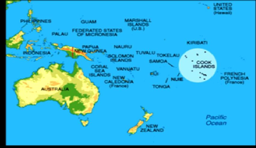
Figure 1b – Map of the
                                                    islands in the Cook
                                                    Islands

Figure 2 - The Cook Islands map showing the 200‐nautical mile
              Exclusive Economic Zone Boundary.
                   SOURCE: (de Scally, 2008)

                                                                             9
1.2.2 Introduction to species and habitat diversity
The diversity of species and habitats found on different islands in the region depends largely on three
factors:
Island size and landforms – generally the larger the island the more landforms it will have that
allow colonisation by different species
Island location – diversity tends to reduce from west to east in the Pacific with distance from the
major source areas of Melanesia and Indo-Malaysia
Island age – the older the island the longer the opportunity for colonisation
The Cook Islands vary markedly in size from Suwarrow Atoll (0.4km2) to Rarotonga (67km2) and in
landforms from volcanic islands to coral cays as identified earlier. They are located well to the west within
the chain of islands in the South Pacific between longitudes 166oW to 157oW. The volcanoes that
submerged to give rise to the atolls in the Northern Cooks are 80 - 100 million years old forming soon
after the Manihiki Plateau, while the Southern Group islands started forming 19 million years ago
(Mangaia) and decrease in age to about 8 million years ago with a gap before Rarotonga formed.
Kloosterman (1976) estimated that the Rarotongan volcano is younger and was formed during the
Pliocene 2.3 - 2.8 million years ago.
The Cook Islands 4th National Report submitted in 2011 contained an island by island review with listings
of the numbers of native species in different groups. This information is summarised in Table 1 with
islands ordered from south to north.
Table 1: Islands and their habitats.
Land Area Highest Terrestrial Inshore marine
Island Island type
(km2)1 elevation (m)2 habitats habitats
Cloud, upland, Fringing coral reef
Volcanic
Rarotonga 67.4 652 lowland, & coastal and shallow
island
forests; wetlands lagoon
Raised Makatea forest,
Mangaia 48.3 169 limestone volcanic scrub, Fringing reef
island wetlands
Raised
Mauke 19.1 29 limestone Makatea forest Fringing reef
island
Raised Makatea forest,
Atiu 26.9 72 limestone volcanic scrub, Fringing reef
island wetlands
Uninhabited Coconut forests &
Takutea 1.0 5 Fringing reef
sand cay some Broadleaf
Raised
Makatea forest,
Mitiaro 22.3 15 limestone Fringing reef
lake
island
1
These figures were provided by Dan-Olaf Rasmussen, National Environment Service based on measuring polygons
of areas from 2010 satellite images. For atolls, land was defined as areas with some vegetation cover.
2
Source: Wood & Hay (1970)
10Uninhabited Coconut forests & Fringing & barrier
Manuae 6.2 10
atoll some Broadleaf reefs, lagoon
Coconut forests Lagoon, saltwater
Volcanic
Aitutaki 18 124 some Broadleaf, & marshes, fringing
island/atoll
wetlands reef
Coconut forests & Lagoon, fringing
Palmerston 2.1 5.3 Atoll
some Broadleaf reef
Coconut forests &
Suwarrow 0.4 3 Atoll Lagoon
some Broadleaf
Coconut forests & Barrier reef, deep
Nassau 1.3 9 Sand cay
some Broadleaf lagoon
Coconut forests & Barrier reef, deep
Pukapuka 3.8 4 Atoll
some Broadleaf lagoon
Coconut forests & Lagoon, brackish
Manihiki 4.9 5 Atoll
some Broadleaf ponds
Coconut forests &
Rakahanga 4 3 Atoll Lagoon
some Broadleaf
Coconut forests &
Penrhyn 10 3 Atoll Lagoon
some Broadleaf
All the atolls and sand-cays should be coconut forest with some broadleaf. (Putting broadleaf
first gives a very wrong idea of their vegetation)
Table 2: Native biodiversity identified on different islands in the Country.
No. of native species present
Island Fern & fern Flowering Corals &
Insects Reptiles Birds Mammals
allies plants sponges
Mangaia 36 107 25 23+ 0 13 2
Rarotonga 94 152 81 195+ 2 18 3
Mauke 23 79 35 11+ 1 17 0
Atiu 26 96 11 15+ 1 14 1
Takutea Not
4 28 1+ 0 8 1
documented
Mitiaro 16 89 11 4+ 0 9 0
Manuae Not Not Not
4 30 8 1
documented documented documented
Aitutaki 10 43 50 34+ 1 8 2
Palmerston Not
3 30 1+ 3 6 0
documented
Suwarrow Not
2 24 1+ 2 11 2
documented
Nassau Not Not Not
3 24 4 0
documented documented documented
Pukapuka Not
3 32 31+ 1 15 1
documented
Manihiki 4 28 1+ 7+ 1 9 0
Rakahanga Not Not
3 28 2+ 7 0
documented documented
Penrhyn Not
3 30 2+ 2 12 3
documented
11Forests
The 4th National report identified threats to forests on Rarotonga from people moving to occupy sites
inland and this has continued though individual areas of forest lost are relatively small. Many of the higher
forest areas in the centre of the island are ‘uninvestigated’ land and thus theoretically protected from
clearance, however there are test cases in which families are attempting to claim such land. The
Environment Impact Assessment (EIA) system is the key mechanism through which clearance of forest
for such development is managed and controlled.
The status of Cook Islands forests is rated as ‘good to fair’ with very little change since a 1992 assessment
(Government of Cook Islands 2017a). The country has one of the highest proportions of intact natural
forests (62%) in the region and ranks third in this proportion for all Polynesian countries. This stability
relates to most development having taken place on land previously cleared for agricultural, the absence
of a commercial forestry industry, and significant forest on several islands covering makatea (limestone
outcrops) which is unsuitable for development.
Figure 3: Forest and other land types in Rarotonga, 2011
(SOURCE: Government of Cook Islands 2017a.)
.
There are currently no national forest conservation programmes. The community-managed Takitumu
Conservation area has measures in place to manage tree removal. Several areas of cloud forest were
recently surveyed and measures identified for their conservation (see section 1.2.3).
It is instructive that a community-initiated Takuvaine Water Catchment Management Plan developed
within the International Waters Project (IWP) to protect the water quality of this Rarotongan watershed
(Rongo 2006) made no mention of forest clearance as a threat requiring management. The main issue
12identified that could threaten the integrity of forests within the catchment was invasive species,
particularly smothering vines.
Wetlands
The Cook Islands has 114.4 hectares of wetlands and 190.9 hectares of swamps (Government of Cook
Islands 2017a) representing four types:
• Freshwater marshes and swamps: on Rarotonga, Mangaia, Atiu, Mitiaro and Mauke.
• Permanent freshwater lakes: Lake Tiriara on Mangaia, Lake Tiroto on Atiu, and Lake Rotonui and
Lake Rotoiti on Mitiaro.
• Tidal salt marsh: at Ngatangiia Harbour on Rarotonga.
• Freshwater streams: on Rarotonga and Aitutaki
The condition of freshwater streams on Rarotonga and Aitutaki is periodically measured by the Ministry
of Marine Resources. Those on Rarotonga are generally in poor condition due to high bacteria and
nutrient level (Government of Cook Islands 2017a). They show a deteriorating change between 2006-
2011/12 due to declining levels of dissolved oxygen and decreasing water clarity. The main causes of the
problem are considered to be faecal bacteria from animal manure and human sewage and these two
together with inorganic fertilizers leading to the increased nitrogen levels. On Aitutaki the status of
streams is also poor with generally higher levels of bacteria than Rarotonga.
Decreasing water quality can lead to increased bacteria and algae levels in the lagoon with consequent
reduced productivity, negative impacts on some tourist activities, and maybe increased levels of
Ciguatera.
Communities on Mitiaro are actively managing the harvest of eels from the lakes on that island using
temporary ra’ui.
Coastal areas
The more accessible coastal areas throughout the country (especially on Rarotonga) have experienced a
reduction in the area of natural ecosystems, including lowland forests and salt marshes and other types
of wetlands. These areas remain under threat from multiple sources, including agriculture, settlement
and infrastructure particularly for tourism. Resorts, hotels and smaller accommodations have been
constructed and are continuing to be constructed in the coastal fringes of Rarotonga and Aitutaki. The
construction of facilities along coast lines, often with sea walls and jetties, can impact on sea currents and
sediment build up, as well as erosion. In the lagoons, the localised removal of coral heads to provide rock
free swimming areas has fragmented and altered habitat critical for reef fish and other species.
Marine habitats
In the most recent published assessment of the state of coral reefs globally, Cook Islands’ reefs were
identified as in a recovery stage after a crown–of-thorns starfish (COTS) outbreak that started around
1995. All sites surveyed were dominated by algae, with large populations of urchins present. Soft corals
13were present, indicating an early recovery stage of the reef. Another positive sign was the absence of
recently dead coral, apparently stable populations of corals and no evidence of COTS (Vieux et al. 2008).
A positive trend of increasing coral cover has generally continued since then across the country, with the
most detailed information available for Rarotonga in a series of surveys (below).
Coral reef monitoring on Rarotonga has been ongoing for around 20 years, with surveys conducted in
1994, 1999, 2000, 2003, 2006, 2009, 2011, and 2014 (Rongo et al. 2015). These surveys showed that the
COTS outbreak that occurred from 1995 to 2001, and to a lesser extent storm surges associated with the
2003 to 2005 cyclones and several coral bleaching events, were the main causes of the degraded state of
Rarotonga's fore reef communities for much of the 2000’s. Mean coral cover was around 5% in 2009,
around 8% in 2011, and 16% in 2014, which clearly showed that coral communities on the fore reef have
been recovering since 2006.
1.2.3. Updated information on species and habitats since 4th National Report
This section summarizes information collected from recent surveys, management and research
programmes.
Native Terrestrial biodiversity
Rarotonga Cloud Forest survey, catchment management and restoration planning
A three-week field survey of cloud forest habitats incorporating three mountain peaks was carried out in
May 2015 (Wildlands Consultants 2016). It was aimed at information gathering to help protect and
enhance the cloud forests of Rarotonga so that their indigenous ecosystems, habitats for endemic
species, and water supply functions are preserved in perpetuity. Rarotonga’s cloud forests are critical for
the conservation of endemic flora, providing habitat for eight of the island’s 10 endemic flora listed by
the IUCN as “Critically Endangered”, “Endangered”, or “Vulnerable”.
The 2015 survey identified 107 vascular plant species and most vegetation communities were dominated
by indigenous species. Three of nine endemic plant species listed by the IUCN as ‘critically endangered’
or ‘endangered’ were located: Coprosma laevigata, Cyrtandra lilianae and Sclerotheca viridiflora. Based
on their rarity, growth form and ecological niches, ex-situ conservation programmes were recommended
for the following threatened plant species beginning with cultivation trials using seed or cuttings:
Rarotonga Garnotia-Grass (Garnotia cheesemanii)
Rarotonga Psychotria (Psychotria whistleri)
Rarotonga Sclerotheca (Sclerotheca viridifolia)
Te Manga Cyrtandra (Cyrtandra lilianae)
Indigenous non-vascular flora, including lichens, mosses, and liverworts, were abundant and further study
of the specimens collected is likely to result in many new species records for the Cook Islands. Twelve
species of landsnails were found of which four were indigenous and eight were introduced, and one or
more species of undescribed endemic Lamprocystis were found on the peak of Te Kou, along with the
endemics Lamprocystis globosa and Lamprocystis venosa. Fourteen species of ants, wasps and a honey-
bee in seven families of Hymenoptera were recorded. The continued presence of herald petrels
(Pterodroma heraldica) was confirmed though potential nesting areas were inaccessible.
14Te Manga - Te Atukura
ridgeline viewed from
eastern summit of Te
Manga
(SOURCE: Tim Martin)
The cloud forests of Rarotonga were assessed as meeting three of the four criteria for recognition as a
Key Biodiversity Area (Table 3).
Table 3: Assessment of Rarotonga cloud forests against the KBA criteria.
Criterion Assessment Justification
Key site for eight vascular plant species that are
1. Globally threatened species Yes
globally threatened.
Supports all of the global population for several
2. Restricted range species Yes
landsnail species and two vascular plant species.
No congregatory species are present in large
3. Congregatory species No
numbers.
One of the largest remaining areas of small-island
4. Biome-restricted low-altitude cloud forest. Retains almost the full
Yes
assemblages suite of plant species and genera restricted to
cloud forest habitats of the tropical Pacific.
The survey identified several threats to cloud forest ecosystems. Invasive plants such as white-flowered
ginger (Hedychium coronarium) and night-blooming cestrum (Cestrum nocturnum) appeared to slowly be
increasing in range and abundance and site-led weed control programmes were outlined. Invasive ants
were located and rats will be a threat to ground-nesting seabirds. Climate change is a particular threat as
the biota of cloud forests has very specific environmental requirements (e.g. high humidity and cloud
cover) and could be displaced through increasing temperatures leading to the upward migration of lower
altitude species.
15Conservation of rare Vairakau Maori (traditional medicine) plants on Mauke and Atiu
This programme was undertaken by
the Integrated Island Biodiversity
Project based at the National
Environment Service, with support
from GEF, UNEP and SPREP. It aimed
to prepare a programme for the
protection and conservation of rare
Vairakau Maori plants, based on the
premise that the way to achieve this
is to encourage practitioners to
continue to practice their medicine.
Three-quarters of the species of
Vairakau maori plants listed as ‘rare’
Vairakau maori ingredients and tools (SOURCE: E Munro)
in the Cook Islands Biodiversity
Database are found on the Southern
Group Islands of Aitutaki, Mitiaro, Atiu, Mauke and Mangaia.
Local consulting group Te Enua, Te Moana e Te Rangi undertook surveys on Atiu and Mauke in 2013/14
interviewing Ta’unga Vairakau Maori (traditional medicine practitioners) and locating plants. An Action
Plan was developed that focused on four elements:
Update rare Vairakau Maori plant information
Deal with threats to rare Vairakau maori plants
Inform people about rare Vairakau maori plants
Encourage Ta’unga Vairakau to continue practicing Vairakau maori.
Case study: Mata’oi on Atiu
According to Kau Henry, a member of the Roro Enua o Enuamanu there are only 5 Mata'oi (Cananga
odorata) trees left on the island of Atiu. These were located during the consultation visit to the Island of
Atiu and plotted using a GPS. With the decline in the island’s population in the last five years, the use of
Mata'oi, not only for making vairakau, but also for making ‘ei (garlands) – has declined. With this decline
few people, except for those
that use the plant for vairakau,
know where they are found.
Mata’oi
(Cananga odorata)
flowers and fruit.
(SOURCE: Cook Natural
Heritage Trust/ Gerald
McCormack)
16Identification of Important Bird Areas (IBA’s) and Key Biodiversity Areas (KBA’s)
The Cook Islands has 36 resident bird species, including six endemics and 15 that are globally threatened.
A recent report identified IBA’s and KBA’s in the Cook Islands (Evans 2012). There are nine terrestrial and
marine IBA’s in the Cook Islands (Table 4) and 18 KBA’s (Tables 4 & 5).
Table 4: Important Bird Areas of Cook Islands (SOURCE: Birdlife International Cook Islands Country Profile)
Name Area (ha) Habitat
Mitiaro 3,000 Terrestrial
Atiu 2,690 Terrestrial
Mangaia 5,200 Terrestrial
Suwarrow Atoll National Park 162 Terrestrial
Takutea Wildlife Sanctuary 127 Terrestrial
Takitumu Conservation Area,
155 Terrestrial
Rarotonga
Aitutaki 1,800 Terrestrial
Suwarrow Atoll Marine 1,240 Marine
Takutea Marine 762 Marine
Table 5: Key Biodiversity Areas of Cook Islands
Name Area (ha) Habitat
The 9 IBA’s in Table 4 are also identified
As Table 4 Terrestrial & marine
as KBA’s
Te Manga-Te Kou Cloud Forest 118 Terrestrial
Takuvaine Water Catchment3 229 Terrestrial
Mauke Island 2,000 Terrestrial
Rarotonga Marine 1,600 Marine
Palmerston Marine 5,400 Marine
Pukapuka Marine 2,800 Marine
Tongareva Marine 22,700 Marine
Manihiki Marine 5,200 Marine
Rakahanga Marine 700 Marine
Areas were identified largely on the basis of the presence of ‘trigger species’. As examples, Atiu has been
identified as a KBA and IBA because of five bird species, five landsnails, an endemic plant and two species
of marine turtle. Takutea is an IBA because of its globally significant population of red-tailed tropicbird.
3
This area is not considered by some local scientists to be of particularly high biodiversity value but it is however
already under community-based conservation management.
17Aitutaki qualifies as a KBA/IBA because of two bird species, six landsnails, an endemic spider and a coral
reef fish, the humphead wrasse.
Conservation of Rarotonga Monarch (Pomarea dimidiata) or Kakerori
The Kakerori has been subject to a conservation programme since 1989. From a low of only 29 birds, the
population was estimated at c.380 birds, including 69 yearlings by August 2011 (supplemented by data
from July 2011) (Robertson et al. 2011, H. Robertson in litt. 2011), suggesting a population of c.310
mature individuals. Between 2001 and 2003 30 birds were introduced to Atiu to establish a reserve
population on an island free of ship rats. This Atiu population currently numbers 50-100 individuals and
they largely occupy forests on the makatea where there is a significant area available and few threats.
Conservation of Rimitara lorikeet (Vini kuhlii) or Kura on Atiu & Mitiaro
Twenty seven of this endangered bird were translocated from Rimatara, French Polynesia to Atiu in the
Cook Islands in April 2007, part of their historic range, in an effort to establish a second population. The
introduction appears to have been successful
with breeding recorded in the first 15 months
and four birds seen on Mitiaro 50km away after
two months. Subsequent population estimates
were c.40 birds in 2009, 90 ± 19 birds in 2010
and 92 ± 24 birds in 2011 although the 2011
estimate is likely to be an underestimate due to
observer error (Malcolm 2011, R. Malcolm in
litt. 2012). The early results of a census in 2016
indicate that the population on Atiu is between
300 and 500 birds and they are widely
distributed in the inland horticultural area
(Gerald McCormack Unpubl. data). The small
group of four Kura moved to Mitiaro in 2007,
with only three Kura found during the 2016
census. Kura or Rimatara lorikeet on Atiu.
(SOURCE: Te Ipukarea Society)
Survey of Rarotonga starling (Aplonis cinerascens) or I’oi
Starlings were surveyed in nine valleys of Rarotonga using distance sampling with 15-minute point counts
(Easby & Compton 2013). Densities varied between zero and 0.95/hectare at different points with an
average of 0.51/hectare leading to a conservative estimate of 2,350 adult birds for the total population.
This suggests that the current IUCN status of ‘vulnerable’ is appropriate. Highest densities of birds were
in the Takitumu Conservation Area where rats are controlled and lowest numbers in valleys where there
were large infestations of introduced climbing vines, indicating that invasive species may be a key threat.
Survey of Atiu swiflet (Collocalia sawtelli)
A survey was carried out of the two nesting caves on Atiu in 2012/13 giving a mean population estimate
of 416 birds (McCormack 2013). Indications are that there has been a 21% decline in numbers at one of
18the caves. A transfer of birds to another island that had swiftlets in the past has been advocated as a
means of reducing the extinction risk for this vulnerable species.
Mauke Island ‘unga (coconut crab) survey (Matamaki et al., 2016).
This survey undertaken in October 2015 and coordinated by the National Environment Service with
assistance from the Secretariat of the Pacific Community (SPC) was the first such assessment in the Cook
Islands. It aimed to collect information on population size, structure and distribution to establish a
baseline and provide recommendations for management. Crabs were found to be confined to the coastal
region and the catch per unit effort (CPUE) suggested a density of 15 crabs/acre and an estimated
population of 22,785 (±4830). The CPUEs were similar inside a ra’ui (community-managed protected area)
set up to conserve crabs and outside this. The CPUEs and the age structure were characteristic of a
population heavily impacted by over-harvesting.
As a result of the survey, the Mauke community is developing management regulations that will prohibit
the taking of smaller crabs and females carrying eggs and establish further ra’ui. A seasonal closure to
hunting and a ban on exports were also proposed. Other islands already have some of these measures in
place: on Manihiki coconut crabs can be consumed only on the island and on Atiu and Mitiaro it is
prohibited to harvesting crabs less than 50mm in thoracic length and egg-bearing females.
Community members from Mangaia and Atiu also participated to facilitate similar surveys being carried
out on their islands. A similar survey was carried out on Mangaia in October 2016.
Native Marine biodiversity
Coral Reefs
Coral reefs in the southern group of the Cook Islands were found to be in good health with good coral
coverage during a 2013 survey by a team of government officials and individuals from non-governmental
organisations who travelled to the islands of Aitutaki, Manuae, Mitiaro, Takutea, and Atiu (Rongo et al.
2013).
A repeat survey of Rarotonga fore reefs in 2014 showed a significant increase of larger coral colonies in
2014 when compared with 2006 (Rongo et al. 2015). Although acanthurids (e.g. surgeonfish Ctenochaetus
striatus) showed a sudden increase in 2006, their abundance with most other fish species surveyed has
remained relatively stable from 2009 and onwards. On the other hand, coral-associated pomacentrids
(damselfish) and chaetodontids (butterflyfish) showed an increase since 2006, which is consistent with
the increase in hard coral cover during this recovery period.
A series of surveys of marine invertebrates have been carried out in different islands in recent years (SPC,
2013, George & Kea 2014a, 2014b, George & Story 2014, George et al. 2014, 2015). These indicate over-
exploitation of some species at some sites and recovery at others after conservation measures were put
in place. A 2013 survey of sea cucumbers across Aitutaki, Mangaia, Palmerston & Rarotonga found
densities of lollyfish and surf redfish to be above ‘regional healthy densities’, however greenfish were
below this level and absent from one island (SPC 2013). Past commercial exploitation of surf redfish had
been halted due to inadequate resource management. Subsequent surveys of two additional northern
19atolls found them to be low in sea cucumber species recorded and size structures with no commercial
potential (George & Story 2014). Giant clams were abundant on Manihiki which was considered to result
from a ban on exports and a ra’ui in place. Surveys of Mauke and Mitiaro which have very narrow reef
habitats also found low sea cucumber populations and size structures (George & Kea 2014). There had
been significant declines in giant clams, large worm shells and rough turban shells which were important
local food resources since 2009 and ra’ui were needed. Pukupuka had low densities and small sizes of sea
cucumbers and very low densities of giant clams (George et al 2014).
Rarotonga has a significant number of marine ra’ui (section 1.2.4). Assessments of invertebrates and
finfish were carried out during 2013 (George et al. 2015) and found a decline in the majority of
invertebrate resources since previous surveys. The two best sites were Edgewater with the highest
densities for five invertebrates and Tikioki with highest finfish biomass. It was identified that some
harvesting takes place in the ra’ui and responsibilities for compliance and monitoring are not clearly
defined, leading to an on-going discussion between the Aronga Mana (traditional leaders), community
and the government agencies.
In 2014 a further assessment was carried out at Kavera following a proposal to create a ra’ui there as a
nursery area for the rejuvenation of marine invertebrates that are heavily harvested in the area (George
& Kea 2014). The survey found eleven invertebrate resources in the ra’ui area and only nine at a similar
unprotected site, with very high densities of two sea cucumbers (Rori toto and Rori Pua) and sea urchins
(Kina) at both sites.
Cook Islands Turtle Project
Since 2009 the Cook Islands Turtle Project (CITP), a collaborative research programme led by the Pacific
Islands Conservation Initiative (PICI), has
surveyed and recorded baseline data on
habitat suitability, nesting frequency
and nest distribution of turtles on
several islands (Table 6 below). PICI aims
to achieve a complete national survey
over 3-5 years and to coordinate repeat
surveys to build up a picture of the
status and trends of the breeding
population. All nests found to date are
considered to be of green turtles
(Chelonia mydas) though hawksbill
(Eretmochelys imbricata) and
loggerhead turtles (Caretta caretta)
have also been recorded in Cook Islands
waters. Turtle nest, Poutukava Beach, Mauke
- 130 eggs laid and 122 hatched
(SOURCE: PICI)
20Table 6: Findings of recent turtle surveys
Island Nests found Comments
Turtles resident year round and
Rarotonga (White 2013) None but 15km of beach suitable most abundant in Papua, Avarua
(PICI 2015) for nesting and Rutaki passages. More green
than hawksbill.
Turtle encounters confined to
Mangaia (PICI 2015) None and no suitable nesting sites
Avarua Harbour
There was evidence of older nests
from previous years on some motu
2012/13 - 6 were found. as well as evidence of nests laid
Aitutaki (PICI 2013, 2015)
outside of the nesting season
(November – February).
None but several beaches and
motu suitable for nesting. Turtles in lagoon year round.
Turtles present year round but
Mauke 2011/12 (Bradshaw & Seven found and 3 more most common during nesting
Bradshaw 2012) ‘possible’. 1.1km of beach suitable (Dec-Mar). Some take of adults
for nesting. and eggs.
Surveys conducted by
Environment Officer on the 10
2012/2013 (PICI 2013) None found. beaches identified as suitable by
previous expedition.
Anecdotal evidence suggests no
None found.
significant nesting on the island for
Atiu 2013 (PICI 2013)
over thirty years.
Beaches that appear as suitable as
None found and none were
those used on Mauke or Mitiaro
2014/15 (Lyon, S. pers comm.) reported by the community.
are present.
There were reports of the
Palmerston 2012 (White 2012) 179 were found. presence of loggerhead turtles
which may nest there.
Nesting was not traditionally
Mitiaro 2014 2 nests found
known from Mitiaro
Penrhyn (White 2014) 523 found. Most nests on Mangarongaro
Management of harvested fish stocks
The Cook Islands has a significant longline fishery targeting several tuna species (Table 7) and a small
fishery trolling for albacore tuna (Table 8) with only 1 boat active in recent years compared to four in
2003 and 2004 with a peak catch of 688 tonnes (WCPFC 2014).
Table 7: Number of vessels and catches (tonnes) for Cook Island longliners
Year 2010 2011 2012 2013 2014
Vessels Active 17 24 24 24 13
Albacore 2423 2182 2757 1354 1276
Bigeye 319 925 1624 208 194
Yellow -fin 192 394 693 346 553
21Blue Marlin 43 39 93 35 33
Black Marlin 19 24 37 11 11
Striped Marlin 24 16 28 12 20
Swordfish 78 41 140 16 14
Blue shark 20 - 23 7 1
Silky shark 15 18 17 5 0
Other 124 135 308 40 137
Total 3257 3774 5720 2034 2239
(Source: WCPFC 2014)
Table 8: Number of vessels active and albacore catches (tonnes) for Cook Island trollers
Year 2010 2011 2012 2013 2014
Vessels Active 0 0 0 0 1
Albacore Catch 0 0 0 0 21
(Source: WCPFC 2014)
A Cook Islands Offshore Fisheries Policy was produced by the Ministry of Marine Resources, assisted by
the SPC in 2013. Its purpose is to ensure sustainable resource management, to make optimal use of
fishery resources, to enhance food security by minimising interaction with coastal fisheries, and
exercising national rights.
The Cook Islands Exclusive Economic Zone (EEZ) South Pacific albacore longline fishery has become the
first Chinese tuna fleet to be certified to the Marine Stewardship Council (MSC) Fisheries Standard. The
fishery produces 2,300 tonnes of tuna per annum.
Since 2013, Anova USA/ Fishing & Living has been involved in the Cook Islands Fishery Improvement
Project for the Cook Islands pelagic longline fishery, as a co-operating partner with Luen Thai Fishing
Venture. The FIP covers all vessels that are participating in the Cook Islands longline fishery, and covers
south Pacific albacore tuna and western and central Pacific yellowfin tuna, which are the two main market
species caught in the fishery. The FIP covers these two stocks caught both within the Cook Islands
Exclusive Economic Zone (EEZ) and on the adjacent high seas.
In October 2016 the Government signed a Sustainable Fisheries Partnership Agreement (SFPA) with the
European Union under which the Cook Islands will receive $9.6 million over a 4-year period in return for
providing access to four European flagged purse seine fishing vessels which will target the migratory and
abundant skipjack tuna. The agreement includes a protocol to fish up to 7,000 tonnes per annum – around
156 fishing days or 12 per cent of the Cook Islands’ 1250 fishing day quota set by the Western and Central
Pacific Fisheries Commission (WCPFC).
MMR has written that; “The fishing opportunities to be granted by the SFPA are based on the best
available scientific advice, in line with the conservation and management measures of the WCPFC. MMR
remains committed to best practice precautionary management of stocks in our exclusive economic zone
through its mandate under the Marine Resources Act 2005 to ensure stocks remain healthy and to
maximize the ecological and economic benefit in the long term for the people of the Cook Islands”. (Media
Release 17 October 2016).
This agreement is controversial. The Aronga Mana or traditional leaders of the Cook Islands, who have
been invested with titles in accordance with native custom and usage are the “tiaki or guardians and
protectors” of the food resources of the sea in accordance with native custom and usage of the Cook
22Islands. Between 17 and 24 October 2016, the Aronga Mana o Te Au o Tonga and Te Ipukarea Society
filed a Judicial Review in the High Court.
The Aronga Mana o Te Au o Tonga claims there was a lack of consultation with traditional leaders as
under the Cook Islands Constitution, traditional leaders are recognised as the guardians of our natural
resources. Both the Aronga Mana o Te Au o Tonga and Te Ipukarea Society in their case claim that an
Environmental Impact Assessment must be carried out for this activity. For TIS, there was no proper
regard to any or sufficient, scientific evidence on the impact of purse seine activities on by-catch species,
including yellow fin tuna and particularly big-eye tuna. TIS is also concerned with the impact of using fish
aggregation devices on by-catch species and non- target species, particularly whale sharks, sharks and
sea turtles.
Invasive species management programmes
Eradication of rats on Suwarrow 2013.
Suwarrow Island is a National Park with globally significant seabird populations, consisting of 30 motu
(islets) fringed around a lagoon with a landmass of c.1.68sq km. Pacific rats were detected on one motu
in 2008 during a seabird survey and four motu were later found to be infested. In May 2013 the National
Environment Service, Te Ipukarea Society and Birdlife International carried out a ground poisoning
operation using the toxin brodifacoum (Munro 2015). Initial indications were that the operation had been
successful, but in 2016 rats were observed on one motu, Motu Tou. A draft Biosecurity Plan has been
developed to minimise the risks of rats becoming re-established in the future, but a further eradication
effort is now required with planning in place for 2017.
Eradication of myna birds on Atiu.
A major programme was initiated on Atiu (2693ha) in 2009 aiming to reduce the numbers of myna to
increase the productivity of kakerori and Rimatara lorikeet recently introduced to the island, and in 2011
the decision was made to attempt an eradication. A programme developed and coordinated by the Cook
Island Natural Heritage Trust has carried out a combination of poisoning, trapping and shooting. In
October 2016 it was considered that the eradication has been successful – a remarkable achievement,
with the shooting of the last four birds. In total about 24,000 mynas were killed during the seven year
programme. There have been no verified reports of mynas since October.
The myna was introduced to the outer islands in the early 1900s to control the Coconut Stick-insect. Since
2013 some areas of coconut palms have been badly damaged by this insect and options are being
considered to manage it, such as clearing weeds from plantations and planting more palms. The local
native birds have increased in numbers and are much more visible (Gerald McCormack pers. comm.).
Biocontrol of weeds.
A weed biocontrol scoping study was carried out in 2012 by Landcare Research (Paynter & Lloyd 2012).
It identified 41 priority weed species of which a smaller number were suitable for biocontrol in the near
term. Two species, the giant sensitive plant (Mimosa invisa) and lantana (Lantana camara), were not
included because they are already well controlled by biocontrol agents that have been introduced to the
Cook Islands. Eight species were identified for initial work and several agents, including Heliconius erato
cyrbia for biological control of Passiflora rubra (red passionfruit), have been successfully released in the
23wild. Heliconius erato has established on Rarotonga and is successfully controlling the target plant
although it is too early to see widespread decline. Before any of these Biocontrol species can be
introduced to the Cook Islands, an EIA process is undertaken by the National Environment Authority for
approval.
Management of pest invertebrates
Eradication of Oriental fruit fly (Bactrocera dorsalis)
This species, one of the most destructive species of fruit and vegetable-infesting flies in the world, was
found in Rarotonga and Aitutaki in May 2013. It was successfully eradicated in September 2014 by a major
programme by the Ministry of Agriculture, with the assistance of National Environment Service and
Ministry of Health at a cost of over $246,000 (Cook Islands Government $110,000, SPC $80,000, New
Zealand Government $35,000 and Aitutaki Island Council $21,000) together with the services of three
technical experts from SPC and three entomologists from New Zealand.
Studies of no-see-'em biting-midge (Culicoides belkini)
This sand-fly is a recent arrival on two islands and is small enough to pass through mosquito screens so
that communities find it a significant annoyance. The Cook Islands Natural Heritage Trust organised a
team of international experts to visit Aitutaki and Mitiaro in 2015, funded by the NES - GEF-PAS Invasive
Alien Species (IAS) Project to study this species and identify its breeding sites (McCormack 2015). The
midges were observed breeding on the edge of a small swamp on Aitutaki, where follow-up control work
is planned, and in the large central swampland on Mitiaro.
Community-based weed control programmes
Red passion fruit - Mauke
Munro & Kaokao (2015) reported on behalf of NES and the GEF-PAS funded Invasive Alien Species Project
on a programme to control red passion-fruit (Passiflora rubra) which is confined to a single site on Mauke.
There have been several previous attempts to eradicate this plant from 2001 onwards, and the latest
effort was initiated in 2007 led by the Environment Officer based on the island. There have been no
sightings of mature red passion-fruit since 2013 and all juveniles have been killed. However there are
increasing numbers of seedlings germinating from dormant seeds in the ground. Ongoing consistent
efforts are needed to ensure that the seedlings are destroyed before they reach fruit-bearing age.
Beach burr - Pukapuka
A survey was carried out in May 2015 to identify the status and distribution of beach burr (Cenchrus
echinatus) (or piripiri or parango) on Pukapuka and determine the best management method to control
its spread (Munro et al. 2015). Beach burr was located on all three motu of Pukapuka, particularly around
dwellings, access roads and a sportsground. Several significant areas were cleared of the weed by the
survey team and community members.
24Information management
Cook Islands Biodiversity Database
The Cook Islands biodiversity database (http://cookislands.bishopmuseum.org) developed and managed
by the Cook Islands Natural Heritage Trust is currently undergoing a comprehensive re-development,
partially supported by the GEF-PAS Integrated Island Biodiversity Project.
The ‘general user interface’ is currently being finalised with the completion of functions to allow approved
users to upload photos and provide data (e.g. counts). Further work is planned on editorial systems so
that all data can be edited and new data added. There are c1000 new species to be added once this is
complete, mostly insects and fungi. Figure 4 indicates how the new database will readily provide the user
with a range of options for searching and displaying information.
Figure 4: Graphic showing some of the functionality of the new database.
SOURCE: Cook Islands Natural Heritage Trust
1.2.4. Protected Areas
The country’s protected areas are listed/tabulated in several documents/websites but there are
significant differences between each. Table 9 below presents the current available information full list
though some dates of establishment are unrecorded.
25Table 9: Protected Areas in the Cook Islands
Date of
Area Designation Island Area (km2) Category
establishment
Suwarrow
National Park Suwarrow 12.4/1.62 Marine/Terrestrial 1978
National Park
Takitumu
Conservation Other Area Rarotonga 1.55 Terrestrial 1996
Area
1903 (re-
Takutea Wildlife
Other Area Takutea 7.6/1.2 Marine/Terrestrial established
Sanctuary
1950)
Local Nature
Highland Paradise Rarotonga 0.32 Terrestrial Unknown
Reserve
Nature
Moko’ero Nui Atiu 1.2 Terrestrial 2014
Reserve
Maina Reserve Reserve Aitutaki 0.8 Terrestrial est. 1981
Te Miromiro Ra’ui Atiu 0.11/0.09 Marine/Terrestrial Unknown
Te Ana Ra’ui Atiu 0.019 Terrestrial Unknown
Ra’ui
Tikioki Rarotonga 0.4 Marine 1998
motukore
Aroa Ra’ui Rarotonga 0.325 Marine 2006
Pouara Ra’ui Rarotonga 0.05 Marine 2006
Titikaveka Ra’ui Rarotonga 0.5 Marine 1998
0.71 or
Aroko Ra’ui Rarotonga Marine 1998
0.87
Tokerau Ra’ui Rarotonga 0.04 Marine 2007
Maina Lagoon Ra’ui Aitutaki 0? Marine 2000
Ra’ui
Ootu Aitutaki 0.02 Marine 2000
motukore
Motu Kitiu Ra’ui Aitutaki 0.4 Marine 2000
Veitatei Ra’ui Ra’ui Mangaia 0.06 Marine Unknown
Keia Ra’ui Ra’ui Mangaia 0.38 Marine Unknown
Tavaenga Ra’ui Ra’ui Mangaia 0.32 Marine Unknown
Tamarua Ra’ui Ra’ui Mangaia 0.19 Marine Unknown
Keia Puna Ra’ui Mangaia 7.42 Terrestrial 2014
Tavaenga Puna Ra’ui Mangaia 11.5 Terrestrial 2014
Mangaia
Terrestrial
Tanga’eo Ra’ui Mangaia 48.35 2016
(Entire Island)
Sanctuary
Unga Ra’ui Ra’ui Mauke 2.67 Terrestrial Unknown
Auru Ra’ui Mauke 0.43 Terrestrial Unknown
Kakemaunga Ra’ui Mauke 0.13 Terrestrial Unknown
Patito Inaio Ra’ui Mauke 0.05 Marine Unknown
Te Roto Nui Ra’ui Mitiaro 1.14 Freshwater Unknown
26You can also read