CORPORATE PRESENTATION - September 2021 - Cartier Iron
←
→
Page content transcription
If your browser does not render page correctly, please read the page content below
CORPORATE PRESENTATION
      September 2021
                         1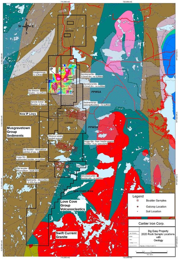
FORWARD-LOOKING STATEMENTS

Certain information contained herein regarding Cartier Iron Corporation, including management’s
assessment of future plans and operations, may constitute forward-looking statements under
applicable securities law and necessarily involve risks, including but not limited to risks associated with
mining exploration, operating costs, production costs, volatility of share prices, currency fluctuations,
imprecision of resource and reserve estimates, environmental risks and ability to access sufficient
capital from internal and external sources.

As a consequence, actual results may differ materially from those anticipated in any forward-looking
statements. Plans, intentions or expectations disclosed in any forward-looking statements or
information should not be read as guarantees of future results or events, and will not necessarily be
accurate indications of whether or when or by which such results or events will be achieved.

Except as required by law, Cartier Iron Corporation, expressly disclaims any intention and undertakes
no obligation to update any forward looking statements or information as conditions change.

The historical mineral resources mentioned are strictly non-compliant to National Instrument 43-101
mineral resource and mineral reserve standards, and should therefore not be relied upon. A qualified
person has not done sufficient work to upgrade or classify the historical mineral resources as current
National Instrument 43-101 compliant.

                                                                                                              2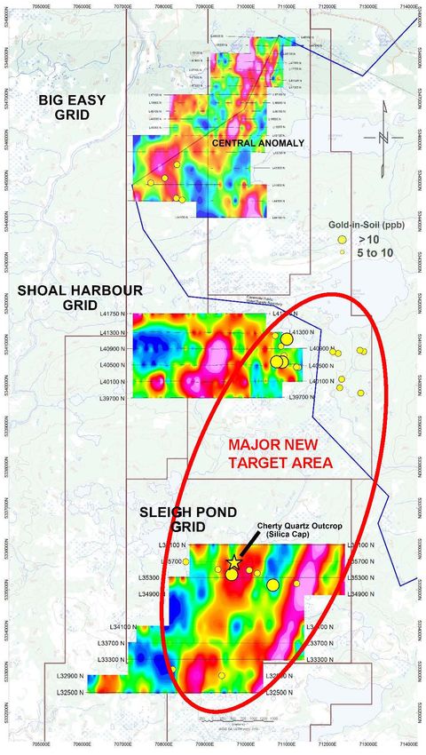
ABOUT CARTIER

    Cartier Iron Corporation is exploring the Big Easy low sulphidation epithermal gold-
    silver property in the Avalon zone of Eastern Newfoundland and has a portfolio of
    highly prospective iron-rich mineral concessions in the northern and southern
    Labrador Trough, Canada’s premier iron ore mining district.

    Cartier has ownership of 2.14 M shares of Eloro Resources Ltd. and Cdn $4 M cash

           BIG EASY PROPERTY                                GAGNON HOLDINGS

•   Big Easy property expanded to 369 claims      •   (141 claims/75 km2) Inferred Mineral
    covering 92.3 km2, 2 hours from St.               Resource of 531 MT grading 33% FeT
    John’s, Nfld                                      (Total Iron) delineated to date at the Lac
•   Historic diamond drilling of 31 holes             Penguin Project
    totalling 6,497 m has outlined an extensive   •   Additional exploration target potential
    mineralized zone ~ 300-400 m wide that            at Lac Penguin Project estimated to be
    has a prospective strike length of 5+ km          700-900 MT of 27-31% FeT
•   Significant historic drill results include    •   Metallurgical tests generated high-
    6.05 g Au/t and 174 g Ag/t over 1.5 m, 7.65       quality, low deleterious element, low
    g Au/t over 1.0 m, 0.80 g Au/t over 11.25         silica (
CARTIER IRON CAPITAL STRUCTURE

                      SHARE DATA as of Sept 19th, 2021
                      CSE: CFE | WKN: A1KB3F

          Common Shares Issued and Outstanding                   140 M

          Options (4.5 M) & Warrants (65.9 M) Issued and
                                                                 70.4 M
          Outstanding

          Fully Diluted (including 1.0 M for Big Easy)           210 M

          Price (Sept. 19, 2021)                              0.12 cents

          Market Capitalization (Sep. 19, 2021)                  $15 M

          Champion Iron owns 9.9% of Cartier Iron and Mgmt,
          Directors, own another 9.9%

                                                                           4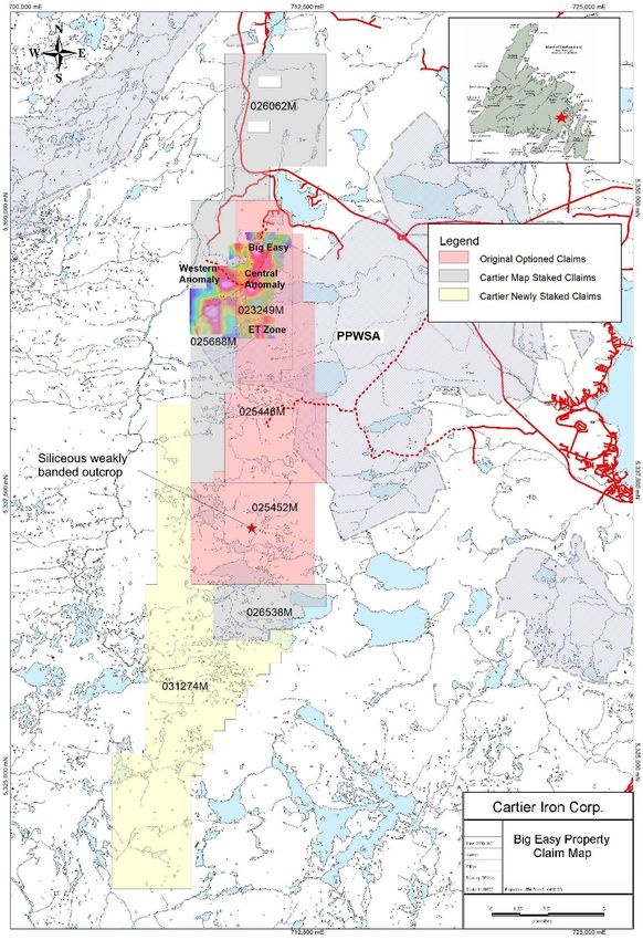
EXPERIENCED MANAGEMENT TEAM

                                OVER 100 YEARS of combined technical
                                and financial experience in exploration
                                and mining projects

  MANAGEMENT TEAM                               BOARD OF DIRECTORS
  THOMAS G. LARSEN                              THOMAS G. LARSEN
  Chief Executive Officer
                                                DON SHELDON
  JORGE ESTEPA
                                                HARRY BURGESS, P.Eng.
  V.P., Secretary Treasurer
                                                FRANCIS SAUVE
  MILES NAGAMATSU, CA
  Chief Financial Officer                       ALEXANDER S. HORVATH, P.Eng.

  TECHNICAL TEAM
  Dr. BILL PEARSON, P.Geo.
  Chief Technical Advisor

  PETER WEBSTER, P.Geo.Manager
  Mercator Geological Service

                                                                               5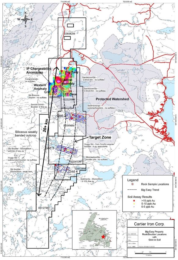
BIG EASY PROPERTY
Newfoundland

• Island of Newfoundland – East Coast   • 5 km off Trans-Canada Highway –
                                         road-accessible
• 2 hours from St. John’s –
 20 minutes from Clarenville            • Power line at northern end of the Big
                                         Easy zone

                                                                                  6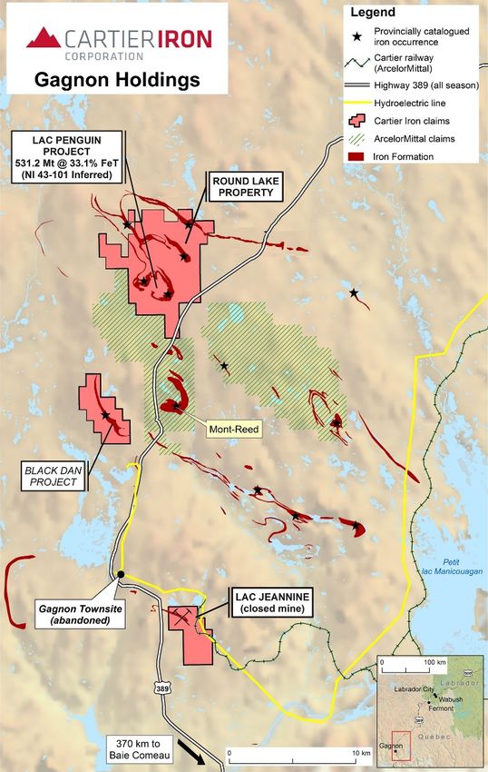
CLAIM MAP

 N
                                             • Big Easy property consists of 625 mining
                                              claims covering 152.3 km2
                                             • Cartier Iron holds a 100% interest having
                                              recently completed acquisition of the core
                                              claims by completing $2M exploration
                                              expenditures and issuing 1M shares

                                   BE21-35   • Property subject to 3% NSR with potential to
                                              buyback to 2.5%

                                                 CENTRAL ANOMALY
                                                                                BE18-32

                                                                      BE21-35
                                                            BE21-36
                                                BE18-30
LEGEND
   Original Claim Block
                          1,500m
   New West Claim Block
                                         Central Anomaly area looking NNE showing previous drilling
                                                                                                7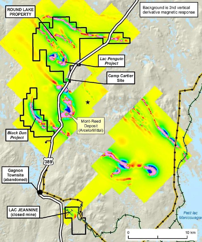
REGIONAL GEOLOGY
Avalon Zone

Haile Mine (Oceana Gold)                      Hope Brook Mine (Big Ridge Gold)
• Producing 180 k to 200 k oz                 • Production 1987-97 – 752,163 oz Au
  Au per year
                                              NI 43-101 Mineral Resource
• P&P reserves – 58.2 Mt at                   • Indicated: 5,500,000 t at 4.77 g Au/t –
  1.71 g Au/t – 2,910,000 oz Au
                                                  844,000 oz Au
  2.21 g Ag/t – 3,750,000 oz Ag
                                              •   Inferred: 836,000 t at 4.11 g Au/t –
Source: Oceana Gold Corp.September 23, 2020
                                                  110,000 oz Au          Source: First Mining Gold   8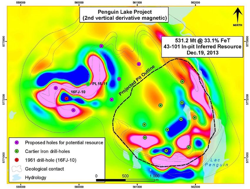
REGIONAL GEOLOGICAL SETTING

•   Northern extension of the 275 km-long Burin
    Peninsula epithermal gold belt
•   Mineralization hosted in silicified
    epiclastic units near faults

Recognition as a Significant
Au/Ag District
•   Discovery Big Easy by Jim Harris & Phil
    Saunders following up 10 ppb Au lake sediment
    anomaly in Grassy Pond
•   Exploration/drilling Big Easy – 2010-2016 by
    Silver Spruce/Lloyd Hillier
•   Work by NL Geological Survey/Memorial
•   Exploration by Puddle Pond Resources –
    Lamaline area – recently optioned to Golden Ridge
    Resources
•   Hickey’s Pond - Bonavista Resources
•   Root & Cellar - Northern Shield
                                                        9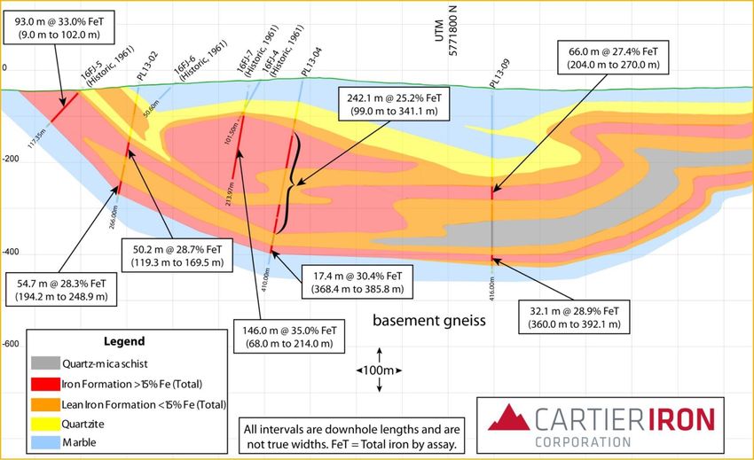
REGIONAL GEOLOGICAL SETTING

                                      Mineralization at Big Easy
                                  Low Sulphidation Epithermal Au-Ag

• Neoproterozoic back arc or continental          • Extensive low sulphidation epithermal
 arc basin                                         system with multiple mineralizing events
• Epiclastic sediments with some volcanic         • Three major showings identified –
 component and local flow banded rhyolites         Big Easy, Central and ET Zone over
                                                   3.5 km strike length
• Remarkably preserved with finely banded
 silicia gels indicating at paleo-surface         • Target zone now extends for 20+km

                     2 cm                                            2 cm

 BE12-12 @ 202.6 m      7.9 g Au/t & 130 g Ag/t   BE12-09 @ 12.9 m     2.0 g Au/t & 17 g Ag/t
                                                                                                10
BIG EASY PROPERTY
Model
Source: Modified from Buchanan 1981
11BIG EASY PROPERTY
System
Big Easy System:
Pervasive Alteration/Mineralization
Colloidal Silica ET Zone Ginguro Banding Bladed Textures
• Classic low sulphidation • Strike length of 5+ km on
epithermal Au-Ag system original property
• Big Easy, Central & ET • Current property covers
showings cover 3.5 km strike potential 20+ km strike
length length
12PROPERTY GEOLOGY
N
BIG EASY
2 cm
CENTRAL
BE14-16 20.6 m Typical barren red epiclastics
ET ZONE
Source: Newfoundland and Labrador Geoscience Atlas 13BIG EASY PROPERTY 2020 PROGRAM
• Received drilling permit for Central Anomaly
drilling for Winter 2020 but was not able to
complete due to COVID-19 delays.
• Geological mapping, prospecting and soil
geochemical surveys carried out in Summer
2020.
• Results very positive – outlined 20+km long
target zone for epithermal gold
mineralization
• Located significant outcrop of weakly banded
silicified cherty quartz in southern part of
property – most likely siliceous sinter part
of a silica cap
• Low amplitude gold anomalies 10-18ppb in
soils along target zone
• Located float boulders of quartz along target
zone
14HELICOPTER-BORNE MAGNETIC
SURVEY FALL 2020
• Helicopter-borne magnetic survey flown
for New Sense Geophysics Ltd. by
Newfoundland Helicopters over the
southern half of the property in Fall
2020
• Two major magnetic trends outlined,
West and East Trends, 19km and
20km long, respectively, each with a
number of elongated magnetic highs
that likely reflect intrusive rocks not
previously recognized in this area.
• West Trend is likely southerly extension
of Big Easy-Central Anomaly-ET trend.
• East Trend reflects two major
intersecting structures that coalesce in
the area of the weakly banded, cherty,
quartz outcrop where anomalous gold
values were found in soils 15BIG EASY PROPERTY
Diamond Drilling 2010-2016
• Total historic diamond drilling of 31 holes totalling 6,497 m
mainly on Big Easy
• Extensive mineralized zone approximately 300 to 400 m
wide with prospective strike length of 5+ km and open to
the north and south
• Significant historic drill results include:
• 6.05 g Au/t and 174 g Ag/t over 1.5 m (Hole BE-11-13)
• 7.65 g Au/t over 1.0 m (Hole BE-11-07)
• 0.80 g Au/t over 11.25 m (Hole BE-12-10)
• 1.30 g Au/t over 8.7 m (Hole BE-12-12)
• 3.54 g Au/t and 511 g Ag/t over 2.0 m (Hole BE 16-22)
2 cm
BE12-12 @ 202.6 m 7.9 g Au/t + 130 gAg/t
Source: Newfoundland and Labrador, Department of Natural Resources, Mines Branch Assessment File Reports on theProperty.
16BIG EASY PROPERTY
IP Chargeability
OPEN
• Initial IP/Resistivity Surveys BIG EASY
completed in Winter 2018
• Chargeability highlighted Big Mx Chargeability (n=4),
25 & 50 m dipoles mV/V
Easy and ET Zones in
addition to New Targets across 4+ km long
chargeability anomaly
a 4 km Strike Length marking major
epithermal system
• Central Anomaly drilled in CENTRAL
CENTRAL
2018 but only on edge due to
anomaly being under a bog
• Chargeability anomaly is open ET ZONE
to the north and south
OPEN 600 m
172021 WINTER DRILLING CENTRAL ANOMALY
• Two new holes tested the core
Cross Section Drilling Central Anomaly
area of the Central Anomaly
which is approximately 200m
wide and is located below the
centre of a bog.
• Hole BE-21-35 returned 0.45 g/t
Au and 9.7 g/t Ag over 34m incl.
two intervals grading 1.36 g/t Au
and 77.8 g/t Ag over 1m and 1.35
g/t Au and 14 g/t Ag over 1m
• Hole BE-21-36 intersected 0.62
g/t Au and 16.12 g/t Ag over
13m, including 1.07 g/t Au and
36.66 g/t Ag over 5.0m between
198 and 203m
• IP chargeability anomaly
indicates mineralized zone is at
least 600+m long and appears
stronger at depth
18NEW IP CHARGEABILITY TARGETS BIG EASY
• March-April, 2021 39.5 line-
km of additional
IP/Resistivity on 400m
spaced lines on Sleigh Pond
grid outlined major target area
• Chargeability data show a
prominent NE-trending high
over almost 5 km
• Western chargeability
anomaly lies on strike with
and projects toward the Au-in-
soil geochemical anomaly
previously recognized on the
Shoal Harbour grid, about 5
km farther to the NE
• Drilling on Sleigh Pond
planned in Winter 2022
19CSAMT SURVEY CONFIRMS MAJOR STRUCTURE
• Fall 2021 19.4 line-km of
CSAMT on 200m spaced
lines on Big Easy – Central
Anomaly target area
• Confirms low sulphidation
epithermal mineralization
occurs along a major
structural break and is
potentially large
• High resistivity to east of
major structure may reflect
intrusive rocks that are
potential heat source.
• “Sweet spot” in epithermal
system likely deeper; drill
program has been adjusted in
light of this new information
Big Easy Section 46300N Combined Resistivity
20OUR APPROACH GOING FORWARD
If you want to find a big deposit,
get into a big system –
Big Easy is a BIG SYSTEM.
WHAT WE KNOW WHAT WE DON’T KNOW
• Major low sulphidation epithermal • Where are the sweet spots in
system with general NNE-SSW strike the system? – likely deeper
• Significant gold mineralization is • Is there potential for multiple
associated with major IP chargeability centres of epithermal gold
anomalies and low resistivity mineralization along this major
structure?
• Gold mineralization and alteration occurs
along a major structural break • What are the structural controls?
• Most of prospective area is covered by • Project continues to advance but
bogs and lakes/ponds hence geophysics much further exploration is
& drilling are the most important tools required to fully evaluate.
21OUR PLAN IN 2021-2022
• Cartier recently raised $5.2M
for Big Easy
• 10,000m diamond drill • Drilling
program in progress on planned to
Central Anomaly to follow-up test new IP
encouraging results in Winter anomalies on
2021 program Sleigh Pond
• Drill program has been Grid in
adjusted in light of new Winter 2022
information from CSAMT
survey
THE MOST IMPORTANT FACTOR IN EXPLORATION IS PERSISTENCE!
STAY TUNED!
22CARTIER IRON CORPORATION PORTFOLIO
in the Labrador Trough
Canadian-based iron ore explorer in the
Labrador Trough, Canada’s premium
iron ore mining district
Gagnon Holdings (141 claims/75 km2)
• Iron-rich mineral concessions in the southern
Labrador Trough
• Inferred Mineral Resource of 531 MT
grading 33% FeT (Total Iron) delineated to
date at the Lac Penguin Project
• Close proximity to hydroelectric, road,
• Additional exploration target potential* and rail-networks that connect to port
at Lac Penguin Project estimated to be
facilities at Sept-Îles and Port-Cartier, on
700-900 MT of 27-31% FeT
the Gulf of St. Lawrence
• Metallurgical tests generated high-quality, • Cartier Iron holds a 55% interest in the
low deleterious element, low silica (STRATEGIC SHAREHOLDER
Champion Iron Mines Limited
(Wholly-owned subsidiary of CHAMPION IRON LIMITED - TSX:CIA)
CARTIER IRON’S - JOINT VENTURE PARTNER
Champion Iron Limited Acquired Past-Producing Bloom Lake
Mine in April 2016
• TSX:CIA /ASX:CIA
• Market Cap: C$477 million (April 12, 2018) • Acquired for C$9.75M in cash and assumed
liabilities of C$42.8M
• Iron production, development and exploration
company focused on its flagship Bloom Lake • Held in Quebec Iron Ore Inc. (“QIO”); 63.2%
property in Quebec owned by Champion and 36.8% owned by
Resources Quebec
• Owns 100% of its subsidiary Champion Iron
Mines Limited (Cartier Iron’s JV partner) • Past owners invested almost US$3.0 billion
on mine development and infrastructure
Bloom Lake Mine Successfully Re-Started
in Q1 2018 Strong First Quarter Production
Results at Bloom Lake
• Completed equity and debt financings in October
2017 - Champion spent C$326.7M in CAPEX • Champion reported strong operational and
upgrades to the Bloom Lake Mine and Plant financial results for quarter ended June 30, 2018
• Decision to restart production at Bloom Lake • Quarterly net income of $20.7 million from
Mine was announced Nov. 2017 and operations $150.7 million in revenue during ramp-up phase
recommenced on Feb. 16, 2018, ahead of • Operating costs of $56.15 per tonne, lower
schedule and within budget than forecasted
• First shipment of Bloom Lake Mine iron ore • Average realized price of $86.61 per tonne
concentrate commenced loading at the Port of on concentrate sales
Sept-Iles on March 25, 2018
24LABRADOR TROUGH
Canada’s Premier Iron Ore Mining District
Labrador Trough
• 1,100 km iron-rich belt that extends southwards
from Ungava Bay, through Quebec and Labrador
• Iron ore mining operations active since 1954
• Falling prices in the mid-1980s downsized the
regional iron ore sector
• Improved spot prices and regional
infrastructure led to a resurgence in both
Labrador and Quebec
• The Labrador Trough currently has producing
mines as well as several major projects in the
advanced stages of exploration and development
• Champion Iron Limited’s subsidiary, Quebec Iron
Ore, re-started Bloom Lake Mine in Q1 2018
25LABRADOR TROUGH
Existing Rail Infrastructure
Existing Rail
Infrastructure
Quebec North Shore & Labrador (QNS&L) Railway
• Common-carrier link to Sept-Îles / Pointe Noire
• Allocates capacity on a first-come, first-served basis
Quebec Cartier Railway (ArcelorMittal)
• Built by Quebec Cartier Mining Co.
• Privately-owned link to Port-Cartier
Bloom Lake Railway (Champion Iron Acquired)
• Common-carrier link from Bloom Lake Mine to
QNS&L railway
La Société Ferroviaire du Nord Québécois,
Société en Commondite (“SFNQ”)
• SFNQ was formed as a partnership between the
Government of Quebec, Champion Iron Limited andAdriana
Resources – to manage and implement a Feasibility Study
for a new Quebec Labrador Trough rail line
26WORLD CLASS PORT OF SEPT-ÎLES
Expanding to Meet Demand
Pointe Noire
Expanding
Sept-Îles
Pointe Noire Multi-User Wharf
• Completed in late 2015 Pointe Noire
• Phase 1: 50 Mtpy $220 million
• Federal Government contributed $55 million
funding – 25% of the project
• Phase 2: Planning for 100 Mtpy
Port of Sept-Îles
• Rio Tinto-IOC shipping facility
Port-Cartier
Government of Quebec
• $68 Million acquisition of rail and port
• ArcelorMittal shipping facility
infrastructure, previously owned by Wabush Mines • Previously announced a $2.1B expansion
JV and Cliffs Resources, through Plan Nord and including concentrator expansion with
Investissement Quebec (Feb. 2016) port and rail infrastructure upgrades
• Located 62 km west of Sept-Îles
27GAGNON HOLDINGS
Iron-rich Mineral Concessions in the Gagnon Terrane
Iron-rich Mineral
Concessions
• Gagnon Holdings: 141 claims covering 75 km2 in
the southern Labrador Trough
• Gagnon Terrane affected by the Grenville Orogeny
– the iron formation has been highly deformed and
coarsened by metamorphism, reducing extraction and
beneficiation requirements
• Structural thickening and the interference effects of
ideal bowl-shaped exploration target at
Lac Penguin
• Iron formation comprises quartz-specularite,
specularite-hematite, magnetite-hematite, and
mainly-magnetite members
28LAC PENGUIN PROJECT
Development
EXPLORATION
TO DATE
• Inferred Mineral Resource of 531 MT grading
33% FeT based on 3,315 m (10 holes) that intersected
2,580 m of iron formation (I.F.)
• 1,600 core-metres of rich oxide iron formation was
intersected (i.e. >15% FeT)
• Mostly fine to medium-grained magnetite with minor
medium-grained specularite-hematite rich intervals
• Drilling is supported by overland access from
Highway 389 – no helicopter support required
• Lac Penguin hosts estimated additional 700-900 MT
of 27-31% FeT, based on 3D resource model and
2015 drilling
• Metallurgical tests generated high-quality, low
deleterious element, low silica concentrate
(4.5% SiO2), grading 64.2% to 66.6% iron
29LAC PENGUIN PROJECT
Cross Section A-A’ Section 61800E
A Looking West A’
30LAC PENGUIN PROJECT
Cross Section B-B’ Section 61400E
B Looking West B’
31MINERAL RESOURCE ESTIMATE
Lac Penguin Project (Dec. 2013)
GLOBAL IN‐SITU MINERAL RESOURCE ESTIMATE
IN‐PIT MINERAL RESOURCE ESTIMATE
* The quantity and grade of the reported Mineral Resources within the Project are categorized as Inferred Mineral Resources. Inferred Mineral Resources are that part of a Mineral Resource for which quantity and grade
or quality can be estimated on the basis of geological evidence and limited sampling and reasonably assumed, but not verified, geological and grade continuity. The estimate is based on limited information and
sampling gathered through appropriate techniques from drill core. There is no guarantee that further exploration will upgrade the Inferred Mineral Resources to Indicated or Measured Mineral Resources. Mineral
Resources which are not Mineral Reserves do not have demonstrated economic viability. The estimate of Inferred Mineral Resources may be materially affected by environmental, permitting, legal, title, taxation,
socio‐political, marketing, or other relevant issues. 32LAC PENGUIN
Metallurgical Testing
Low deleterious element content from Lac
Penguin concentrates are considered of
premium quality by the industry
• High-quality, low-deleterious element • Metallurgical tests were targeted toward
concentrate, grading >65% iron reported producing a concentrate of 66% Fe and ≤4.5%
from Lac Penguin deposit. Maximum level SiO2 from an average sample grade of 30%
of 4.5% SiO2 for the concentrate is a value- Fe. Stage 1 gravimetric separation tests by
level imposed by Cartier Iron, guided by Wilfley Table on 18 samples returned average
today’s selective market requirement for the grades of 64.2 to 66.6% Fe, 4.5% SiO2 and
highest quality concentrate 1.1% MgO
• Test results carried out by SGS Laboratories • Many of the world’s largest sources of iron
(Quebec) to date indicate that iron resources concentrate are problematic from a quality
at Lac Penguin deposit most efficiently perspective, being relatively high in silica,
liberated by a 2-stage process following phosphorous, alumina and other elements that
initial grinding to produce a final sinter product are deleterious to blast furnace performance
and steel quality
33LAC PENGUIN
3D Modeled Resource
Additional
Modelled resource (tan)
(700-900 MT)
34LAC PENGUIN PROJECT
Proposed drill-holes (purple) to delineate additional
700-900 MT of 3D-modeled iron formation
35GAGNON HOLDINGS
Iron-rich Mineral Concessions in the Gagnon Terrane
Iron-rich Mineral
Concessions
• Inferred Mineral Resource of 531 MT grading
33% FeT at Lac Penguin
• Metallurgical tests indicate a high-quality iron
concentrate, very low in deleterious elements,
grading 64-66% Fe, from Lac Penguin
composite samples
• Over 20 km in cumulative strike-length of
prospective iron formation defined by
magnetic-response survey
• 7 potentially exploitable iron occurrences with
historic resources, and a past-producing mine
(Lac Jeannine), which produced 266 Mt @ 33%
FeT from 1961 to 1976
• Current NI 43-101 Inferred Resources and
estimated additional resource* from the 3D * The ”exploration-target potential” is not a Mineral Resource. There is insufficient work
deposit model, indicate potential of over 1.0 BT completed to estimate the quantity and grade or quality of the exploration target on the basis of
geological evidence and sampling. There is no guarantee that further exploration will define
from the Lac Penguin Project additional mineral resources from any portion of the exploration target potential.
36WHY INVEST
in Cartier Iron Corporation
BIG EASY PROPERTY – GOLD GAGNON HOLDINGS – IRON ORE
1 EXPLORATION
OPPORTUNITY 1 IDEAL
LOCATION
Historic diamond drilling of 31 holes • Proximal to several iron ore mines
totalling 6,497 m mainly on Big Easy. • Favourable tax environment,
politically stable
• The “Trough” hosts over 1,500 km of iron
formation – source of Canada’s iron ore
2 PROSPECTIVE
GEOLOGY 2 EXCELLENT
INFRASTRUCTURE
• IP chargeability anomaly indicates Connection to low-cost power
mineralized zone is at least 600+m Proximally located to rail and port
long and appears stronger at depth infrastructure
3 PLANNED
PROGRAM 3 HIGH-QUALITY PRODUCT
64.2% – 66.6% FeT withCSE: CFE WKN:A1KB3F
For more information, please contact
Investor Relations at: ir@cartieriron.com
Toll Free (800) 360-8006
Phone (416) 360-8006
Fax (416) 361-1333
Toronto Office
20 Adelaide Street East, Suite200
Toronto, Ontario M5C 2T6
www.cartieriron.comYou can also read


