Geoinformation monitoring of the territory of Western Siberia
←
→
Page content transcription
If your browser does not render page correctly, please read the page content below
E3S Web of Conferences 244, 03026 (2021)                                 https://doi.org/10.1051/e3sconf/202124403026
EMMFT-2020

      Geoinformation monitoring of the territory of
      Western Siberia
      Natalia Martynova1,* and Valentina Budarova1
      1Tyumen    Industrial University, 38, Volodarskogo St., 625000, Tyumen, Russia

                     Abstract. The article is devoted to the use of GIS technology for the
                     control of swamp areas and environmental problems associated with the
                     drainage of swamps in the industrial development of the West Siberian
                     region, the main functions of swampy areas in the biosphere. The study
                     examines the problems of drainage of swampy lands on the example of the
                     territory of Western Siberia. Problems of the "greenhouse effect" and
                     global climate warming, as well as problems of degradation and
                     conservation of permafrost in the cryolithozone. It is established that
                     swamps, as a natural mechanism for removing carbon dioxide from the
                     atmosphere, are the only land geosystems with a constant flow of
                     atmospheric carbon there. The problem associated with gas hydrates and
                     the possibility of activation of microorganisms during the degradation of
                     permafrost has been identified. To date, in the course of scientific
                     experiments and studies based on the observation method, it has been
                     established that natural gas hydrates are extremely sensitive to various
                     technogenic factors.

      1 Introduction and problem statement
      In the modern world, there is an increasing need to obtain information to study and predict
      the needs of the country, so the role of spatial data, remote sensing data, as well as services,
      services and products created on their basis is increasingly increasing. Spatial data is used
      to solve problems facing government agencies at all levels (federal, regional, municipal).
          To effectively use the potential of spatial data, to meet the needs of the economy in
      geoinformation products and services, it is necessary to develop an information
      infrastructure and a digital spatial data platform on a national scale. This will lead to a
      significant acceleration of the development of the country's territories, a more in-depth
      information support of the economy through the integration of geoinformation systems at
      various levels of government (departmental, municipal and others), providing stakeholders
      with quick access to high-quality and up-to-date spatial data. The efficiency of obtaining
      information will increase.
          Modern geographic information systems help not only in collecting spatial data of urban
      areas and agricultural land, but are also used for environmental monitoring, cadastral
      activities and in various sectors of the economy in the country.

      *
          Corresponding author: natali.cherdanceva@mail.ru

© The Authors, published by EDP Sciences. This is an open access article distributed under the terms of the Creative Commons
Attribution License 4.0 (http://creativecommons.org/licenses/by/4.0/).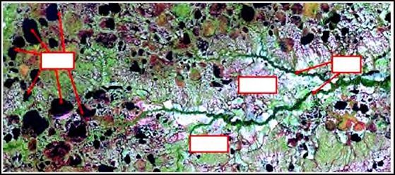
E3S Web of Conferences 244, 03026 (2021)                      https://doi.org/10.1051/e3sconf/202124403026
EMMFT-2020

          It is no secret that the current environmental situation in Russia is unfavourable. The
      result of the industrial development of Russia is large emissions of mining and chemical
      industries, which enter the environment in huge quantities, lead to changes in the
      composition in the atmosphere, soil, and water. These changes negatively affect the state of
      the environment; they can affect the state of the climate, flora and fauna, areas of rivers,
      lakes, reservoirs, and many other processes that occur in nature. The high anthropogenic
      load of the territories, combined with the unfavourable socio-economic situation in Russia,
      also creates a real threat of massive, irreversible changes in natural processes.
          Therefore, the use and expansion of geographic information systems (GIS) tools for
      obtaining information about the state of the environment is becoming the most significant
      task today, since the use of GIS technologies will help to obtain operational, high-quality,
      up-to-date information about the environmental situation in a particular territory, which will
      allow you to quickly and competently take measures to eliminate emerging environmental
      problems or disasters.
          One example of the application of geoinformation technologies for monitoring the
      ecological state of the environment is the tracking of the swamp areas of the West Siberian
      Plain.
          The West Siberian plain is the largest on the globe, a characteristic feature of which is
      its strong swampiest. Bogs occupy three physical and geographical zones (forest-steppe,
      taiga, tundra), where 39% of the world's peat reserves are concentrated. The West Siberian
      region is characterized by huge reserves of peat, so its territory is watered, impassable, and
      in some places completely inaccessible. In economic terms, it is the largest peat region in
      the world with 39 % of the world's peat reserves.
          The West Siberian plain includes forest-steppe, forest and tundra natural-geographical
      zones. The composition of the municipal division includes: Altai, Kemerovo, Novosibirsk,
      Tyumen, Omsk and Tomsk regions.
          In the West Siberian Economic Region, as of 01.01.88, 5004 peat deposits with a total
      area of 32474.2 thousand hectares in the industrial border and 113712.8 million tons of peat
      resources were taken into account. Of these, more than 50 % is located in the Tyumen
      region and about 30 % - in the Tomsk region. The peat resources of the Kemerovo Region
      and the Altai Territory are relatively small, amounting to 178.8 million and 203.4 million
      tons, respectively. The study of peat resources in the West Siberian Economic Region as a
      whole, as well as in most of its constituent regions, is low, and more than 90 % of peat
      resources are forecasted.
          Peat reserves, as well as mineral reserves, are divided according to the degree of study
      into explored (categories A, B and C1), pre-estimated (category C2 and forecast (categories
      P1, Rg, P3). At the same time, the study of peat resources in the southern regions is quite
      significant.
          More than 96 % of the proven peat reserves of the district are located in 148 large peat
      deposits with an area of more than 1000 hectares. At the same time, peat deposits with an
      area of 50 to 1000 hectares predominate in terms of quantity, although peat reserves in
      them account for about 3% of the explored ones. Less than 1 % of peat reserves are
      concentrated in 343 explored peat deposits with an area of up to 50 hectares.
          The main peat reserves (more than 70 %) are concentrated in 106 large peat deposits
      with an area of more than 50 thousand hectares. Among them, a group of unique peat
      deposits is distinguished, such as Vasyuganskoe (53 thousand km2), Kantsiyarskoe (132
      km2), Laimenskoe (502 km2), Salymo-Yuganskoe (732 km2) [1].
          Western Siberia is one of the main industrial centres of the Russian Federation. The
      main industry of the West Siberian region, of course, is the fuel industry, since the largest
      oil and gas fields in Russia are concentrated here. As of 2019, it produces about 70% of oil
      and 90% of gas from the total volume of Russian production, but there are also other

                                                   2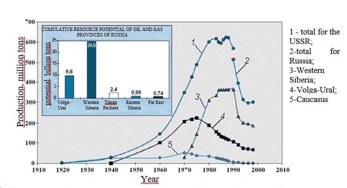
E3S Web of Conferences 244, 03026 (2021)                        https://doi.org/10.1051/e3sconf/202124403026
EMMFT-2020

     industries such as ferrous and non-ferrous metallurgy, mechanical engineering, chemical,
     forestry and food industries.
         The active industrial development of the West Siberian region has recently been
     characterized by a serious deterioration of the environmental situation. Many cities and
     industrial areas of Western Siberia can be classified as an ecological disaster zone. The
     main reason for this is the discrepancy between the scale of man-made impact on the
     natural environment and measures for its conservation, restoration and protection.
     Specifically, this is reflected in the continuous increase in the area and volume of oil and
     gas production, the use of old technologies and the deterioration of existing ones, the
     presence of dangerous chemical and nuclear facilities. Complicating factors include poor
     consideration of the resistance of natural landscapes to man-made impacts, which is
     associated with the peculiarities of the zone of distribution of multi-permafrost rocks and
     the climatic conditions of the dispersion of pollutants in the atmosphere.
         The deterioration of the environmental situation is manifested not only in the
     contamination of the air basin, soil and water resources with radioactive waste, heavy
     metals, and petrochemical products, but also in another problem that is no less important –
     the drainage of the West Siberian swamps for industrial needs.

     Fig. 1. Dynamics of carbon mining by regions of the Russian Federation (Konoplyanik A. A., 2000).
         West Siberian swamps are unique ecological systems and occupy up to 50-70% of the
     entire area of Western Siberia, the primary centres of water logging were depressions in the
     relief, mainly occupied by lake pits with initial deposits of sapropels and peat sapropels
     about 8-8. 5 thousand years old. In the south of the West Siberian Plain, the age of peat
     lands is half that. The maximum area of wetlands in the Vasyugan land, Konda and Surgut
     woodlands associated with outwash fields melting and retreating glaciers. Polesie, for
     example, is frozen in 50-60% of the territories, and together with wetlands occupy the vast
     majority of the area [2-3].
         The West Siberian swamps did not always determine the shape of the earth's surface in
     northern and temperate latitudes, being the result of the post-glacial period of Holocene
     history. This is evidenced by the fact that the geographical distribution of swamps-swamps
     and wetlands: with organo-mineral (forest) and mineral waterlogged soils corresponds to
     the outlines of regions that have undergone Quaternary glaciations [4].
         Swamp ecosystems, being an indispensable attribute of the landscape shell in Western
     Siberia, perform a number of functions: hydrological, geomorphological, climatological,

                                                     3
E3S Web of Conferences 244, 03026 (2021) https://doi.org/10.1051/e3sconf/202124403026
EMMFT-2020
etc., are the last natural complexes where medicinal and food wild plants have been
preserved, as well as a habitat for rare species of the animal world. Marsh plants have a
high nutritional and medicinal value, which is also actively used [5].
However, they also contain the most valuable mineral deposits. The discovery of the
richest deposits of oil and gas in the swampy areas of Western Siberia led to the rapid
development of swamp fields for production. This state of affairs is proved by the dynamics
of carbon mining in the regions of the Russian Federation (Fig. 1) [6].
At the expense of the drained territories, active peat development is underway, the area
of arable land is increasing, since the drained lands are rich in fertilizer, they give high
yields. All this threatens their complete destruction.
The purpose of the study is to determine the impact of industrial development on the
state of swamps in Western Siberia by territorial coverage using GIS technologies.
The aim of the study is to develop a digital model of wetlands and water resources in
the territory of Western Siberia; to assess the dynamics of the development of the territory,
taking into account the influence of industry.
Tracking the dynamics of changes in the water resources of Western Siberia can be
tracked using comparative analysis methods and modern remote sensing technologies
(based on images), and GIS technologies (using software tools).
Therefore, from the point of view of the territorial coverage of Western Siberia as one
of the world's major sources of peat (39% of the world's reserves), research should provide
for a global approach, taking into account the relationship of all natural factors and climatic
conditions. The study should be based on the indicators of the water balance of the territory,
since one of the characteristics of the existence of swamps is water exchange.
2 Methods of research and the materials used
Balanced development of the territory is possible with the use of modern, reliable and
standardized information about spatial objects. By creating digital models and geospatial
data, it is possible to achieve maximum efficiency in the development of territories through
rational planning of residential, industrial and recreational zones, rational zoning of forest
and agricultural land, design of safe roads, etc.
To date, a number of important technologies can be identified that determine the vector
of development of the geoinformation environment at various stages of collecting,
processing and applying spatial information (Fig. 2).
Fig. 2. Stages of collecting, processing and applying spatial information (authors).
4E3S Web of Conferences 244, 03026 (2021) https://doi.org/10.1051/e3sconf/202124403026
EMMFT-2020
In this regard, it is important to ensure the possibility of using modern technologies in
the system of regular geoinformation monitoring, which would allow forming a
comprehensive vision, analyzing changes, providing management and regulation of the
analyzed space, as well as coordinating the development of software tools as necessary.
Also in this regard, the digitalization of the field of spatial data collection, processing and
analysis creates a high investment potential through the development of existing and the
creation of new markets for data, services and services. Therefore, the creation of digital
models of territories allows you to create a system of rational use of land, water resources
and space objects.
Geoinformation technologies allow ensuring the functioning of the T-shaped system of
operational monitoring. This approach is well illustrated in the scientific work of G. I.
Glagolev [7]: "The use of geoinformation systems allows us to model the development of
the ecological situation in various natural environments and clearly see the dependence of
the state of land on sources of pollution, to obtain a comprehensive assessment of the state
of environmental objects based on heterogeneous data."This effect has been extensively
studied [8 – 14]. The method of observation in the geoinformation space of the territory of
swamps and water resources using GIS technologies is shown in Figure 3.
Fig. 3. Methodology for monitoring the geoinformation space of the territory of swamps and water
resources using GIS technologies (authors).
5E3S Web of Conferences 244, 03026 (2021) https://doi.org/10.1051/e3sconf/202124403026
EMMFT-2020
This method allows us to give the most advanced assessment of regulation, planning,
forecasting of environmental protection and rational use of resources using the maximum
possible multi-time data sources and technologies for processing and presenting
information using GIS [14, 15].
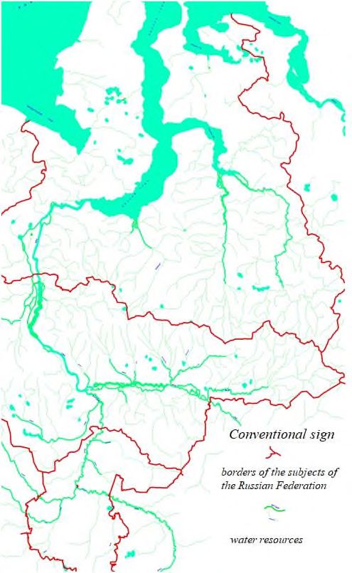
The research area is the territory of Western Siberia.
The objects of the study are swamps and water resources of the territory of Western
Siberia.
The analysis of the dynamics of changes in the territory of swamps is based on images
from open sources, modeling data.
The initial information for the analysis is provided by Google Earth open data sources
in the form of images of the state of the territory of Western Siberia in 2015-2017, for
which the territories of swamps and water resources are selected and determined is shown
in Figure 4.
lakes rivers
swamp
swamp
Fig. 4. Satellite image of part of the territories of Western Siberia from the Google Earth program
with the indication of water bodies.
3 Research results and discussion
In the course research, using GIS technologies (MapInfo Professional - software) and
methods of GIS analysis and image interpretation in 2015-2017, a diagram of the
distribution of water resources in the territory of Western Siberia was compiled from the
Google Earth program (Figure 5). In addition, a digital model of swamps and water
resources was obtained, a fragment of which is shown in Figure 6.
According to the attribute database obtained during the creation of a digital terrain
model in the MapInfo Professional, a decrease in the area of wetlands can be observed for
the total area of wetlands from 2015-2017 (Figure 7).
The total area of swamps for 2015 was 28968 thousand hectares, for 2017 25401
thousand hectares. The comparison showed that the area of wetlands in 2017 less than in
2015 3567 ha.
It is worth noting that examined only part of the territory of Western Siberia, which are
the most exposed to anthropogenic impact, the districts of the Khanty-Mansi Autonomous
Region - Yugra, Yamalo-Nenets Autonomous Region, Kemerovo Region, Tyumen Region,
Omsk Region.
6E3S Web of Conferences 244, 03026 (2021) https://doi.org/10.1051/e3sconf/202124403026
EMMFT-2020
Fig. 5. Satellite image of part of the territories of Western Siberia from the Google Earth program
with the indication of water bodies.
Fig. 6. Fragment of a digital model of swamps and water resources of Western Siberia Fragment.
7E3S Web of Conferences 244, 03026 (2021) https://doi.org/10.1051/e3sconf/202124403026
EMMFT-2020
Fig. 7. Attribute databases of swamp areas for 2015-2017.
The process of reducing the area of wetlands can also be observed in reports on the
environmental situation in Western Siberia. The distribution of land under swamps in all
categories of land in the Omsk Region, Khanty-Mansi Autonomous Region -Yugra, and
Kemerovo Region is presented in Table 1.
Table 1. Font styles for a reference.
Swamp area. (thousand ha.)
Regions and autonomous districts
2016 2017 2018
Omsk region 2142,8 2071,6 2026,8
Khanty-Mansi Autonomous region -
19914,5 19914,5 19913,4
Yugra
Kemerovo region 90,7 90,5 90,4
The table shows that the swamp areas of the regions of Western Siberia are decreasing
annually. However, it is worth bearing in mind that not only anthropogenic factors, but also
natural factors, affect the reduction of the swamp area.
The results of the study showed that the drainage of wetlands of Western Siberia
activates a number of processes that form the problem of the greenhouse effect and global
warming, as well as the degradation and preservation of permafrost, as the marshes are a
natural mechanism for carbon dioxide out of the atmosphere, this is the only geosystems
land with a constant flow back of the atmospheric carbon that they store two times more
carbon than all the forest areas of the planet.
In connection with the active use of water resources, the issues of pollution and
especially water depletion have already become of paramount importance. And here the
role of the West Siberian marshes is very significant. They accumulate 1000 km3 of
moisture, which is 2.5% of the annual flow of the Ob River in the Salekhard city area [16].
As giant vaporizers, they deliver significant amounts of water vapour – the main
greenhouse gas that contributes to cloud cover-to the atmosphere. At the same time, in such
a process, first, a cooling effect for rocks is manifested, since 90% of the solar energy
coming to the Earth is spent on evaporation. This is important from the point of view of
preserving the permafrost, its conservation, and secondly, peats have low thermal
conductivity [1].
The moisture evaporating from the swamps condenses in the atmosphere around the
condensation nuclei, and in the summer, the air flows of the meridian direction are
transferred to the south in the amount of about 300 km3. in the form of liquid meridional
precipitation in the territories of Kazakhstan and Central Asia. For comparison, the project
of the channel for transferring water from the Irtysh River to Central Asia provided for only
8E3S Web of Conferences 244, 03026 (2021) https://doi.org/10.1051/e3sconf/202124403026
EMMFT-2020
25 km3. per year. It can be assumed that if there were no atmospheric drainage of the
swamps of Western Siberia, many territories of Kazakhstan and Central Asia would suffer
from desertification.
Also, during dehumidification, there is a serious problem associated with gas hydrates
and the possibility of activation of microorganisms during the degradation of permafrost.
The experimental and field data accumulated to date have shown that natural gas hydrates
are extremely sensitive to various man-made influences (temperature increase, reservoir
pressure decrease), as a result of which their decomposition occurs, accompanied by active
gas release, changes in thermal and filtration properties.
For the formation of gas hydrates and obstacles to their expansion must be performed a
certain temperature and pressure conditions. Favourable conditions for the formation of
natural gas hydrates exist both on land, mainly in the areas of permafrost distribution, and
almost the entire area of the sea and ocean floor, due to the favourable combination of
temperatures and pressures for their formation. In the bottom sediments of the seas and
oceans, gas hydrates (in particular methane hydrates) are in a solid, relatively stable state as
a result of enormous pressure [17]. On land, the stable state of gas hydrates is provided by
low-temperature permafrost.
During the degradation of permafrost, gas hydrates begin to break down with the release
of methane into the atmosphere, increasing the greenhouse effect, and are a time bomb.
Therefore, its conservation, including peat bogs as natural heat stabilizers, is very
important. Therefore, it is impossible to allow the destruction of swamps in the industrial
development of the northern regions. On agricultural land, the development of low-lying
swamps is possible with their transformation into the original state of freshwater lakes,
using the construction of agricultural landscapes based on nature-compatible technologies
[18].
To all this, we can add that the degradation of permafrost negatively affects the
resistance to destruction of buildings and structures, pipeline systems, roads, bridges, oil
and gas storage facilities, in northern latitudes. Therefore, it is necessary to widely use
different designs of heat stabilizers in large quantities.
4 Conclusion
The use of GIS technology will allow you to visualize the accumulated material, quickly
search and select objects that fall into the area of interest. The results of water and air
samples can be converted into electronic form for further processing and analysis, which
will allow you to quickly identify existing environmental problems and make competent
decisions to eliminate them.
The West Siberian marshes are an important part of the planet's ecosystem. The
processes of drainage of swamps as a result of the industrial development of Western
Siberia can cause serious irreversible environmental processes such as: violation of the
temperature regime, desertification of some parts of the planet's territory, reduction of water
resources, destruction of flora and fauna, etc. Therefore, the problem of dehumidification is
more relevant than ever and therefore special attention should be focused on it. Especially
considering the area occupied by swamps on the territory of the Russian Federation.
References
1. A. A. Zemtsova, 2nd edition, Sibnet 72 (2000)
2. V. L. Telitsyn, Technogenic evolution and optimal use of soils in swamp systems 261
(2004)
9E3S Web of Conferences 244, 03026 (2021) https://doi.org/10.1051/e3sconf/202124403026
EMMFT-2020
3. N. M. Chumakov, Nature 5, 66-80 (1997)
4. V. A. Zubakov, Global climate events in the Pleistocene 286 (1986)
5. A. A. Sirin, A. A. Maslov, N. A. Valyaeva, O. P. Tsyganova, T. V. Glukhova, Forest
Science 65-71 (2014)
6. A. A. Konoplyanik, Oil industry 4, 1-5 (2000)
7. G. I. Glagoleva, Modern Research and Development 3 (20), 706-709 (2018)
8. T. A. Rudich, O. A. Tkacheva,bApplication of geoinformation systems in ensuring the
rational use of natural resources, International Student Scientific Bulletin 4-4, 534-
535 (2016)
9. O. V. Bogdanova, E. G. Chernykh, A. V. Kryakhtunov, Revista ESPACIOS 39 (16),
36 (2018) http://www.revistaespacios.com/a18v39n16/a18v39n16p36.pdf
10. V. A. Budarova, N. V. Cherezova, N. G. Martynova, Yu. D. Medvedeva, A. V.
Dubrovsky, RevistaESPACIOS 39 (16), 37 (2018)
http://www.revistaespacios.com/a18v39n16/18391637.html
11. V. A. Budarova, N. G. Martynova, Yu. D. Medvedeva, V. P. Budarov,
RevistaESPACIOS 39 (26), 22 (2018)
http://www.revistaespacios.com/a18v39n26/18392622.html
12. A. V. Budarova, N. G. Martynova, Yu. D. Medvedeva, V. P. Budrov, Oil and gas of
Western Siberia: materials of the scientific and technical International Conference,
200-202 (2017)
13. A. V. Budarova, Yu. D. Medvedeva, N. G. Cherdantseva, Bulletin SSGA 2 (34), 169-
183 (2016)
14. A. P. Karpik, Methodological and technological bases of geoinformation support of
territories (Novosibirsk: SGGA, 260, 2004)
15. V. A. Zheleznyakov, Development of a methodology for geoinformation operational
updating of large-scale electronic maps using a spatial data bank 140 (2014)
16. M. I. Neustadt, L. K. Malik, Nature 11, 24-35 (1980)
17. V. V. Malakhov, E. N. Golubeva, A. V. Eliseev, G. A. Platov, International
Conference on Environmental Observations, Modelling and Information Systems:
Enviromis-2018, Session 2, 94-98 (2018)
18. V. L. Telitsyn, Yu. A. Novikov, Oil and gas 4, 130-136 (2018)
10You can also read