Using Unmanned Aerial Vehicles (UAV) for Monitoring Biodiversity Measures in Periurban and Agrarian Landscapes - gis.Point
←
→
Page content transcription
If your browser does not render page correctly, please read the page content below
Full Paper                                                                                              273

Using Unmanned Aerial Vehicles (UAV) for
Monitoring Biodiversity Measures in Periurban
and Agrarian Landscapes
Matthias Pietsch1, Matthias Henning2, David Mader3, Patrick Westfeld3, Florian Etterer4
1Anhalt  University of Applied Sciences, Bernburg/Germany · matthias.pietsch@hs-anhalt.de
2Prof. Hellriegel Institute e.V., Bernburg/Germany · matthias.henning@hs-anhalt.de
3Institute of Photogrammetry and Remote Sensing, TU Dresden, Dresden/Germany ·

david.mader@tu-dresden.de
4Institute of Landscape Architecture, TU Dresden, Dresden/Germany · florian.etterer@tu-dresden.de

Abstract: Current farming systems and the land use change are driving forces of biodiversity loss.
Based on the Convention on Biological Diversity (CBD) and the Federal Nature Conservation Act in
Germany compensation measures are planned and implemented to develop appropriate structures in
agrarian landscapes. Therefore a sufficient monitoring is needed. One aim of the project “stadt
PARTHE Land” is to use unmanned aerial vehicles (UAV) together with imaging sensors for monitor-
ing of compensation measures and the development of indicators. Based on three examples the use of
multispectral (true color, near-infrared and thermal infrared) images were tested. Used indicators are
vegetation indices for potential habitats, thermal infrared signatures to detect characteristic bird species
(e. g. skylark) and the examination of the correct implementation (location, size, restrictions) of com-
pensation measures. The results showed that UAV can be used for future applications.
Keywords: UAV, biodiversity, monitoring

1        Introduction
Land use change and the physical and functional disconnection of ecological networks rep-
resent one of the driving forces of biodiversity loss (BUNDESAMT FÜR NATURSCHUTZ 2004,
SPANGENBERG 2007). While farming lead to a more varied landscape in the past, intensive
agricultural production since the 1950s has contributed to biodiversity decline. Both land-
scape structures and plant and animal species that were adapted to extensive farming disap-
peared.
The Convention on Biological Diversity (CBD) and the National Strategy on Biological Di-
versity (NBS) in Germany have the objective to counter this trend by sustainably managing
agriculture landscapes. Landscape planning based on the Federal Nature Conservation Act,
as one possible instrument in Germany, shapes strategies for sustainable conservation and
long-term development of nature and landscapes (BUNDESAMT FÜR NATURSCHUTZ 2002).
Mitigation and environmental compensation measures as part of the impact mitigation pro-
cedure are required based on nature conservation law at municipal level. The aim is to pre-
serve natural potential and functional capacity of ecological services (fauna/flora and their
habitats, soils, water, air, climate, scenic quality). In addition the implementation by land
owners or land users is very important. Therefore measures are described in detail during the
planning procedure and a two-phase monitoring (implementation and functionality) is nec-
essary.

Journal of Digital Landscape Architecture, 3-2018, pp. 273-282. © Wichmann Verlag, VDE VERLAG GMBH ·
Berlin · Offenbach. ISBN 978-3-87907-642-0, ISSN 2367-4253, e-ISSN 2511-624X, doi:10.14627/537642029.
This article is an open access article distributed under the terms and conditions of the Creative Commons
Attribution license (http://creativecommons.org/licenses/by-nd/4.0/).
274                                            Journal of Digital Landscape Architecture · 3-2018

The purpose of the research project “stadt PARTHE land” is to develop appropriate struc-
tures and region-specific action strategies for a sustainable cultural landscape management.
One of the goals of the project (2014-2019) is to develop concepts and implement measures
to enhance or restore the quality of biodiversity in periurban and agrarian landscapes. Also
the evaluation and implementation of mitigation and compensation measures is important.
Different measures to promote biodiversity were planned and implemented in the years 2014
to 2017 in cooperation with local farmers. A monitoring concept was designed that included
field mapping of different species groups (e. g. birds, butterflies, bees, ground beetles) and
vegetation as well as indicators for the ecological services described above. Starting in 2015
the monitoring was performed for all implemented measures.
Unmanned Aerial Vehicles (UAV) have the potential to support nature conservation admin-
istrations with periodic reporting commitments (GUO et al. 2017, SCHMIDT et al. 2017).
Therefore various types of cost-effective remote sensing data (e. g. true color, multispectral,
LiDAR, thermal data) with very high spatial resolution and flexible acquisition periods can
be used (MAYR et al. 2017). Hence the potential support of UAV for monitoring purpose was
tested in addition to the field mapping activities. Multispectral data, consisting of true color
(RGB), near-infrared (NIR) and thermal infrared (TIR) images was captured during flights
in 2016 and 2017. An additional compilation of indicators based on the planning procedure,
the implementation process with local farmers and the two-phase monitoring has been devel-
oped and tested for the implemented measures. This paper will present and discuss first re-
sults of UAV-based agriculture and landscape monitoring.

2     Project stadt PARTHE land
2.1   Project Area and Implemented Measures
The project area is a region in the east of the city of Leipzig with about 16.670 ha. It ranges
from dense urban to vast rural areas. Core and connecting element of the region is the small
river Parthe with its wetlands (Fig. 1).

                                                Eilenburg

           A14

                      Parthe                         Wurzen

      Leipzig

                                               A14

                    A38
                                                     Grimma

Fig. 1: Project area “stadt Parthe land” (Openstreetmap, CC-BY-SA 2.0)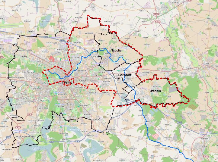
M. Pietsch et al.: Using Unmanned Aerial Vehicles for Monitoring Biodiversity Measures 275
Ten potential compensation measures were implemented with three local farmers in 2014
and 2015. For three of them multispectral data was collected (Tab. 1). The expected func-
tional capacity of ecological services, especially of habitats for representative fauna and flora
in agrarian landscapes, was described for the monitoring.
Table 1: Selected compensation measures for testing UAV
No. Measure Area Aim
01 Fallow land 2.000 m2 Diverse vegetation, habitats for bees, but-
terflies and representative bird species
02 Skylark plot 38 (each 50-100 m2) Habitat for skylark and other characteris-
tic bird species
03 Flower strips (combina- 19.000 m2 Diverse vegetation, habitats for bees, but-
tion sowing/fallow land) (1.500 m × 12-15 m) terflies and characteristic bird species
(a) (b)
Fig. 2: Development of flower strip (measure 03) in (a) July 2015 and (b) September 2015
3 Hardware
The use of UAV as a multi-sensor platform is a powerful tool for time and cost efficient
monitoring. In addition to imaging sensors, the UAV were equipped with a navigation system
consisting of a GNSS sensor (Global Navigation Satellite System) for determination of the
position and an IMU (Inertial Measurement Unit) for orientation. Thereby the images can be
geo-referenced.
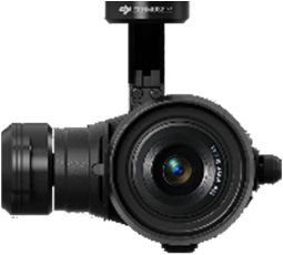
In the stadt PARTHE land project, two UAV-systems were used for data acquisition, a DJI
Inspire 1 quadrocopter (Fig. 3a) with the DJI ZENMUSE X5 camera (Fig. 3b) and a Cadmic
Goliath octocopter (Fig. 3c) with a multi camera system (Fig. 3d). The camera specifications
are shown in Table 2.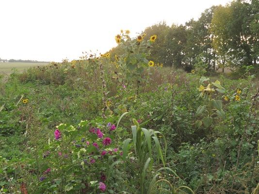
276                                            Journal of Digital Landscape Architecture · 3-2018

           (a)                  (b)                     (c)                      (d)
Fig. 3: (a) DJI Inspire 1 (DJI 2017), (b) ZENMUSE X5 camera (DJI 2017), (c) Cadmic
        Goliath octocopter, (d) camera bar including a RGB-, NIR-, thermal camera

Table 2: Imaging sensors
UAV                 DJI Inspire 1                         Goliath Octokopter
Imaging sensor      DJI ZENMUSE        Mako G-419C         Mako G-223B       FLIR A65 (TIR)
                    X5                 (RGB)               (NIR)
Focal length        15 mm              12.5 mm             12.5 mm           13 mm
                                       25 mm               25 mm             25 mm
Ground sample       3.54 mm            6.6 mm              6.6 mm            19.6 mm
distance at 15 m                       3.3 mm              3.3 mm            10.2 mm
Sensortype          CMOS               CMOS                CMOS              Uncooled
                                                                             microbolometer
Resolution          4608 × 3456 px     2048 × 2048 px      2048 × 1088 px    640 × 512 px
Frame rate          7 Hz               26,3 Hz             49,5 Hz           30 Hz
Radiometric         no                 300 to 750 nm       830 to 1.000 nm   7.5 to 13 µm
characteristic      information

4     Methods
4.1   Multi-Image Processing
A visual impression of compensation measures can be obtained by geo-referenced and high-
resolution images. However, those images are showing only a small section of a large area.
For this reason image-based data sources like 3D point clouds and orthophotos are more
usable for monitoring tasks. 3D point clouds represent the captured area in discrete 3D points
with cartesian coordinates (X, Y, Z) and other given attributes (e. g. RGB, NIR, temperature,
indices, …). Orthophotos are a 2D projection of an area without perspective distortion effects.
Instead of using a single image, an orthophotomosaic, consisting of single orthophotos, in-
crease the coverage of an area. By using geo-referenced images, the 3D point clouds and
orthophotos or orthophotomosaics were also geo-referenced and became true in scale, which
allows the measurement of distances and areas.
With knowledge of the interior orientation of the image (focal length c, principial point x0’),
the camera’s position (X0) and orientation (ω, φ, κ) in space, the reconstruction of a single
3D point P or a 3D point cloud is possible (Fig. 4). It is required that corresponding points
are mapped in two or more images. Therefore, the reconstruction of a 3D object requires the
positions and orientations of the overlapping images resulting from a bundle block adjust-
ment. By using the resulting point cloud and the oriented images, an orthophoto can be gener-
ated. Further information can be found in literature like LUHMANN et al. 2013.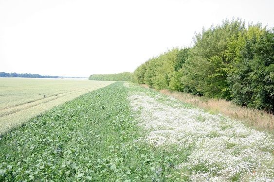
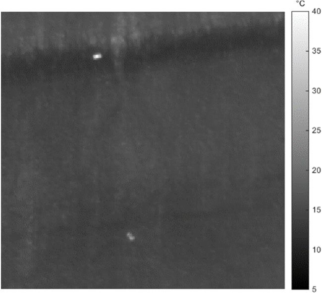
M. Pietsch et al.: Using Unmanned Aerial Vehicles for Monitoring Biodiversity Measures     277

Fig. 4: Photogrammetric measurement principle (WESTFELD 2011)

4.2   Indicators for Monitoring
The implementation (step 1) and expected functional capacity (step 2) of compensation
measures must be evaluated by field mapping and defined indicators. The acquired orthopho-
tos were used to check the implementation. Additional indicators for the functional capacity
according to Tab. 1 are the following.
Habitats
Skylark plots are used for foraging and landing by characteristic birds of agrarian landscapes.
Skylarks are breeding in their surroundings and are sensitive towards disturbance. Based on
the thermal infrared images and field mapping the breeding success was analyzed.
Potential habitats
Vegetation indices or band ratio parameters identify plant biomass versus soil and residue
backgrounds and are used in precision crop management and weed control (MEYER & NETO
2008). There exist different vegetation indices which are calculated from RGB or NIR-image
data. They are used to identify potential habitats for representative bees and birds as well as
the diversity of vegetation. Four vegetation indices were tested (Tab. 3).
Implementation of compensation measures
Compensation measures must be implemented with care. Especially for skylark plots re-
strictions exist (e. g. minimum distance to trees is 50m, in between machine tracks, minimum
distance to field’s edge is 25m). Location and size are important. For this reason, the mainte-
nance must be monitored. Hence, aerial orthophotos were used for visual interpretation and
measurement.
278 Journal of Digital Landscape Architecture · 3-2018
Table 3: Tested vegetation indices
Index Formula Reference
Normalized Difference Green Red PEREZ et al. 2000
Vegetation Index (NDI) NDI
Green Red
Excess-Green-Index (ExG) WOEBBECKE et al.
ExG 2 Green Red Blue
1995
Red-Green-Index (RGI) Red COOPS et al. 2006
RGI
Green
Green-Leaf-Index (GLI) 2 Green Red Blue HUNT et al. 2011
GLI
2 Green Red Blue
5 Results
5.1 Data Acquisition
Table 4 shows an overview of the measures and the used UAV-system with their captured
image data, the mean flight height and the resulting ground sample distance (pixel size on
ground). For generation of 3D point clouds and orthophotos the images need to overlap 80%
in flight direction and 60% between flight strips. Due to limitations regarding the image-
capturing mode of the ZENMUSE X5 camera, 4K image sequences up to 30 images per
second were recorded and single images extracted for further processing.
Table 4: Information about the data acquisition
Measure Altitude Ground Sample Distance System Data
No.
01 35 m 8.26 mm DJI RGB
02 13 m 5.72 mm Goliath RGB, NIR, TIR
03 21 m 4.96 mm DJI RGB, 4K image sequence
03 11 m 4.84 mm Goliath RGB, NIR, TIR
5.2 Detection and Localisation of Ground Breeders (e. g. Skylark)
Thermal infrared images were tested for the monitoring of breeding success in selected sky-
lark plots in 2016 and 2017. The early morning hours are the right moment to detect skylark
breedings based on difference in temperature. Therefore a heating pad was prepared for
calibration. In Fig. 5, the heating pad and a potential skylark breeding are visible. While in
practice the breeding success is evaluated by singing male skylarks, thermal infrared images
may help to detect nests. For this, the difference in temperature between the background and
the skylark has to be known.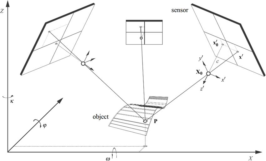
M. Pietsch et al.: Using Unmanned Aerial Vehicles for Monitoring Biodiversity Measures 279
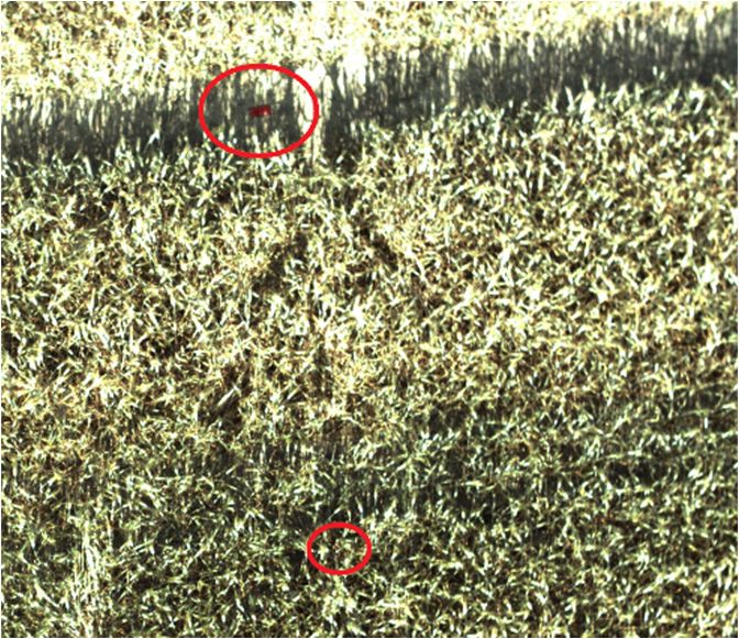
(a) (b)
Fig. 5: (a) Thermal data with potential skylark (lower red part) and prepared heating pad
(upper red part). (b) The same section in RGB data.
5.3 Detection of Bare Soil and Biomass as a Quality Indicator
To detect potential habitats of bees and measure the scale of diversity inside compensation
measures, vegetation indices were tested to identify the proportion between vegetation cover
and bare soil (Fig. 6). To classify the results, 100 control points were used. The Excess-
Green-Index has the highest accuracy with 88 %, Red-Green-Index 84 %, Green-Leaf-Index
81 % and the Normalized Difference Vegetation Index 74 % (Fig. 6).
Excess-Green-Index Green-Leaf-Index Red-Green_Index
Normalized Difference Vegetation Index Aerial Image
Fig. 6: Comparison of different vegetation indices to analyze vegetation cover and bare soil
in skylark plots (HENNING 2017)
Tests in fallow land or flower strips lead to different results due to dry vegetation. In the
examined sites, the accuracy differs in comparison to skylark plots. But if there is bare soil
as a quality indicator, it is possible to detect.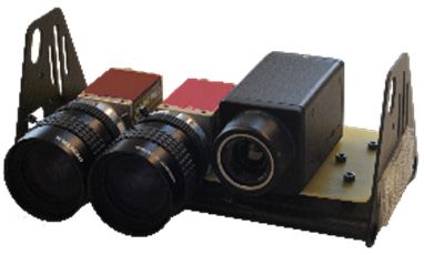
280 Journal of Digital Landscape Architecture · 3-2018
Fig. 7: Excess-Green_index for flower stripes (HENNING 2017)
Unmanned Aerial Systems (UAV) are a helpful tool in verifying the implementation and
restrictions for compensation measures especially during the whole growing season
(Fig. 7).
In summary, the potential of UAV was identified in periodic monitoring of compensation
measures. It is suitable especially for the monitoring of species that are sensitive towards
disturbance (e. g. skylark). Another advantage is the documentation of compensation meas-
ures by the acquired data, which can be reprocessed later.
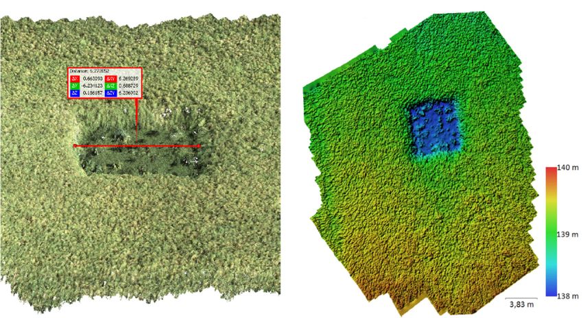
Fig. 8: Skylark plot: measuring distance in a point cloud (left), digital elevation model
(right)
6 Discussion
The two tested platforms produce different aerial images. Extracting images from image
sequences lead to deterioration of quality, because of compression techniques by DJI
ZENMUSE X5 camera. Wind and missing sights influence the quality of the produced or-
thophotos, too. Therefore, mission planning to plan, control and manage the flights is essen-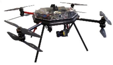
M. Pietsch et al.: Using Unmanned Aerial Vehicles for Monitoring Biodiversity Measures     281

tial for the described monitoring. The implementation and consideration of restrictions of
compensation measures can be checked during the whole growing season. UAV can support
the monitoring of functional capacity. Nevertheless if field work is needed (e. g. vegetation
mapping) in addition to UAV-based data recordings, cost-benefit analysis have to be dis-
cussed. The examples demonstrate that the detection of some indicators (e. g. potential hab-
itats, breeding success) is possible. The combination of field work and automated or semi-
automated detection of indicators should be discussed and improved in the future.

7     Conclusion and Outlook
UAV have the potential to support monitoring biodiversity measures in agrarian landscapes.
Especially for species that are sensitive towards disturbance and hard to find by field mapping
(e. g. skylark). Thermal infrared recordings may help to detect such species with higher ac-
curacy in the future and improve the evaluation of specific measures (HOFFMANN et al. 2012).
Therefore, research especially in temperature differences is needed to develop species de-
pendent signatures. User manuals for an efficient use of UAV in monitoring is needed and
should be prepared for practical use. Cost-benefit analysis for field mapping and UAV-based
data recordings for monitoring purpose is needed. A discussion between experts (field map-
ping, monitoring, UAV, remote sensing) and practitioner (administration, management, na-
ture conservation) is necessary to develop and evaluate indicators and support the use of
UAV and the development of software application for the future.
This work has been funded by the Federal Ministry of Education and Research (BMBF),
grant identifier 033L119D.

References
BUNDESAMT FÜR NATURSCHUTZ (Hrsg.) (2002), Landscape planning for sustainable munic-
   ipal development, Leipzig.
BUNDESAMT FÜR NATURSCHUTZ (Hrsg.) (2004), Empfehlungen zur Umsetzung des § 3
   BNatSchG „Biotopverbund“. Reihe Naturschutz und Biologische Vielfalt, Heft 2, Bonn-
   Bad Godesberg.
COOPS, N. C., MATT, J., WULDER, M. A. & WHITE, J. C. (2006), Assessment of QuickBird
   High Spatial Resolution Imagery to Detect Red Attack Damage due to Mountain Pine
   Beetle Infestation. Remote Sensing of Environment, 103 (1), 67-80.
DJI, DA-JIANG INNOVATIONS SCIENCE & TECHNOLOGY CO., LTD (2017), DJI company’s
   website. http//www.dji.com/de, 2017 (accessed: 2017-03-01).
GUO, Q., SU, Y., HU, T., ZHAO, X., WU, F., LI, Y., LIU, J., CHEN, L., XU, G., LIN, G., ZHENG,
   Y., LIN, Y., MI, X., FEI, L. & WANG, X. (2017), An integrated UAV-borne lidar system
   for 3D habitat mapping in three forest ecosystems across China. International Journal of
   Remote Sensing, 2954-2972.
HENNING, M. (2017), Verwendbarkeit von RGB-Aufnahmen zur Beurteilung von Umsetzung
   und Funktion ausgewählter produktinsintegrierter Kompensationsmaßnahmen unter Zu-
   hilfenahme von GIS-basierten Auswertemethoden. Masterthesis, University Salzburg.
282                                          Journal of Digital Landscape Architecture · 3-2018

HOFFMANN, J., BERGER, G., WIEGAND, I., WITTCHEN, U., PFEFFER, H., KIESEL, J. & EHLERT,
   F. (2012), Bewertung und Verbesserung der Biodiversität leistungsfähiger Nutzungssys-
   teme in Ackerbaugebieten unter Nutzung von Indikatorvogelarten, Berichte aus dem Ju-
   lius-Kühn-Institut 163, Braunschweig.
HUNT, E. R., CAVIGELLI, M., DAUGHTRY, C. T., MCMURTREY, J. & WALTHALL, S. L. (2005),
   Evaluation of digital photography from model aircraft for remote sensing of crop biomass.
   Precision Agriculture, 6 (4), 359-378.
LUHMANN, T., ROBSON, S., KYLE, S. & BOEHM, J. (2013), Close-range photogrammetry and
   3D imaging, Walter de Gruyter, Berlin.
MAYR, M., MALß, S., OFNER, E. & SAMIMI, C. (2017), Disturbance feedbacks on the height
   of woody vegetation in a savannah: a multi-plot assessment using an unmanned aerial
   vehicle (UAV). International Journal of Remote Sensing, 1-25.
MEYER, G. E. & NETO, J. C. (2008), Verification of color vegetation indices for automated
   crop imaging applications. Computers and electronics in agriculture, 63, 282-293.
PEREZ, A. J., LOPEZ, F., BENLLOCH, J. V. & CHRISTENSEN, S. (2000), Color and shape analysis
   techniques for weed detection in cereal fields. Computer and Electronics in Agriculture,
   25, 197-212.
SPANGENBERG, J. H. (2007), Biodiversity pressure and the driving forces behind. Ecological
   Economics, 146-158.
SCHMIDT, J., FASSNACHT, F. E., NEFF, C., LAUSCH, A., KLEINSCHMIT, B., FÖRSTER, M. &
   SCHMIDTLEIN, S. (2017), Adapting a Natura 2000 field guideline for a remote sensing-
   based assessment of heathland conservation status. International Journal of Applied Earth
   Observation and Geoinformation, 61, 61-71.
WESTFELD, P. (2011), Geometrische und stochastische Modelle zur Verarbeitung von 3D-
   Kameradaten am Beispiel menschlicher Bewegungsanalysen.
WOEBBECKE, D. M., MEYER, G. E., B. K., V. & MORTENSEN, D. A. (1995), Color indices for
   weed identification under various soil, residue and lighting conditions. Transactions of
   the ASAE, 38, 259-269.
You can also read