About RIEGL Innovation in 3D - GIM International
←
→
Page content transcription
If your browser does not render page correctly, please read the page content below
About RIEGL Innovation in 3D
Agenda

 www.riegl.com
www.riegl.com
           Copyright RIEGL Laser Measurement Systems GmbH © 2020 – All rights reserved.            Innovation in 3D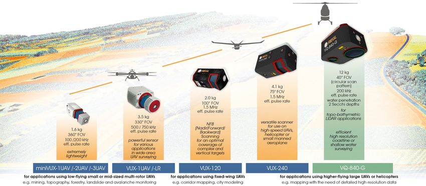
About RIEGL
                                                                                          RIEGL has been producing LiDAR systems commercially for more than 40 years and focuses on
                                                                                          pulsed time-of-flight laser radar technology in multiple wavelengths. RIEGL’s core ”smart
                                                                                          waveform” technologies provide pure digital LiDAR signal processing, unique methodologies for
                                                                                          resolving range ambiguities, multiple targets per laser shots, optimum distribution of
                                                                                          measurements, calibrated amplitudes and reflectance estimates, as well as the seamless
                                                                                          integration and calibration of systems.

                                                                                          RIEGL’s various 3D scanners offer a wide array of performance characteristics and serve as a
                                                                                          platform for continuing “Innovation in 3D” for the laser scanning industry.

                                                                                          From consultation and quotation to integration of the system, as well as training and support,
                                                                                          RIEGL maintains an out-standing history of reliability and support to their customers.

                                                                                          The RIEGL staff comprises 220 highly skilled and motivated engineers, technicians, and other
                                                                                          qualified employees.

 www.riegl.com
www.riegl.com
           Copyright RIEGL Laser Measurement Systems GmbH © 2020 – All rights reserved.                                                                                  Innovation in 3D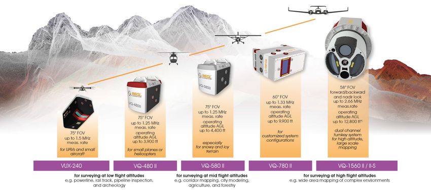
Worldwide sales, trainings
     and services

     Headquarters
                                                                                             About RIEGL
     and offices in Austria:
     Horn
     Vienna
     Salzburg
     Styria

     Main offices:
     Winter Garden, FL, USA
     Tokyo, Japan
     Beijing, China
     Southport, Australia
     Toronto, Canada
     York, United Kingdom

     Worldwide network of
     distribution partners

 www.riegl.com
www.riegl.com Copyright RIEGL Laser Measurement Systems GmbH © 2020 – All rights reserved.                 Innovation in 3D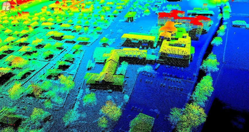
About RIEGL      The RIEGL headquarters provide more than 40,000 square feet work space for
                                                                                                               research, development, production as well as for marketing, sales, training and
                                                                                                               administration. Another 350,000 square feet of open-air ground is used for product
                                                                                                               testing.
                                                                                                               In 2021, an additional manufacturing building in Horn, which will almost double the
                                                                                                               currently available operating space, will be ready for move in.
     Marketing, Sales, Training &                             Vienna Office, Millennium Tower
     Administration

           Research, Development & Production                                                                                                CNC Production
                                                                                              Outdoor 3D-Test Range
                                                                                                                                                                              additional new building

 www.riegl.com
www.riegl.com  Copyright RIEGL Laser Measurement Systems GmbH © 2020 – All rights reserved.                                                                                        Innovation in 3D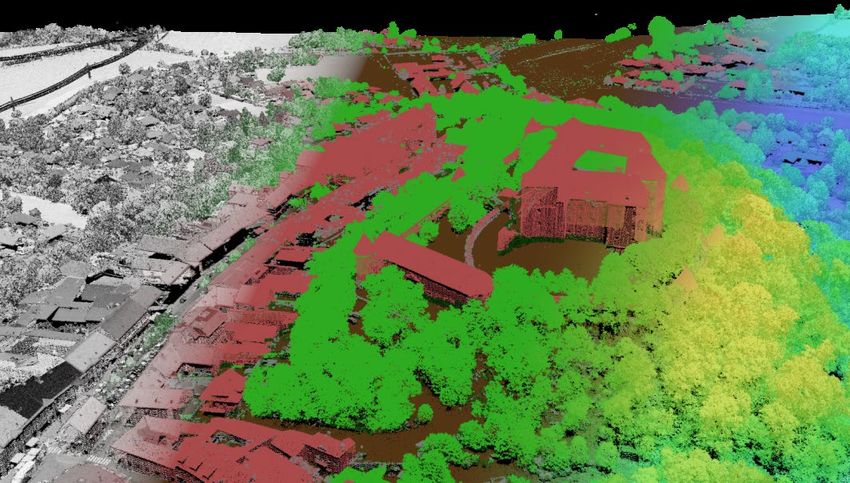
About RIEGL
                                                                                             To meet or to exceed the requirements
                                                                                             Electromagnetic Compatibility Check
                                                                                             Every RIEGL Laser Scanner has to meet or exceed the requirements of the
                                                                                             European Standard EN 61326-1:2013 concerning electrical equipment for
                                                                                             measurement, control and laboratory use and is therefore especially tested.
       Airfield for UAV tests and demo flights,
                                                                                                                                                                                                     Electromagnetic
                            Frauenhofen, Horn                                                Measuring Section                                                                                       compatibility
                                                                                             RIEGL scanners‘ measuring capability is verified here.                                                  check

                                                                                             Calibration Field
                                                                                             Before delivery every RIEGL terrestrial laser scanner has to stand the proof at
                                                                                             the calibration field to review geometric adjustment, compass alignment,
                                                                                             internal calibration, etc.
                                                                                             Airfield for UAV Tests
                                                                                             For verification of RIEGL’s UAV LiDAR sensors‘ or RiCOPTERs‘ performance
                                                                                             – but also for demo flights – special airfields in Horn and Styria are available.
       Airfield for UAV tests and demo flights,
                                         Styria                                                                                                                                  Measuring section    Calibration field

 www.riegl.com
www.riegl.com Copyright RIEGL Laser Measurement Systems GmbH © 2020 – All rights reserved.                                                                                                     Innovation in 3D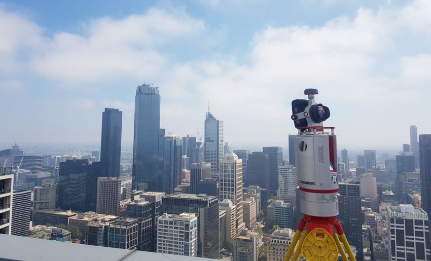
www.riegl.com
www.riegl.com
           Copyright RIEGL Laser Measurement Systems GmbH © 2021 – All rights reserved.   Innovation in 3D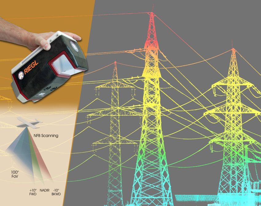
Terrestrial Scanning

www.riegl.com   Copyright RIEGL Laser Measurement Systems GmbH © 2021 – All rights reserved.   Innovation in 3D
Terrestrial Laser Scanning

                                                                                               RIEGL's Terrestrial (Static) Laser Scanners are exceptionally compact and fully portable instruments
                                                                                               providing detailed and highly accurate 3D data rapidly and efficiently.

                                                                                               RIEGL’s unique Waveform-LiDAR technology – based on echo digitization, online waveform
                                                                                               processing, and multiple-time-around processing – is the key for high speed data acquisition. A
                                                                                               new processing architecture of the VZ-i Series enables execution of different background tasks
                                                                                               (such as point cloud registration, geo-referencing, etc.) on-board in parallel to the acquisition of
                                                                                               scan data.

                                                                                               Applications of RIEGL terrestrial laser scanners are wide ranging, including topography, as-built
                                                                                               surveying, mining, architecture, archeology, cultural heritage documentation, monitoring, civil
                                                                                               engineering and city modeling.

www.riegl.com   Copyright RIEGL Laser Measurement Systems GmbH © 2021 – All rights reserved.                                                                                       Innovation in 3D
RIEGL VZ-i Series
Ultra high-performance 3D terrestrial laser scanning systems
•     automatic registration during data acquisition
•     simultaneous image and scan data acquisition
•     cloud connectivity via Wi-Fi and LTE 4G/3G
•     remote control via app
•     customizable workflows
•     rugged design, fast set-up, user-friendly touch screen
•     optional camera, various built-in sensors
•     advanced flexibility through support for external peripherals and
      accessories
•     versatility by customized apps delivering real-time on-board final
      results
•     fully compatible with the RIEGL VMZ hybrid mobile mapping system
•     eye safe operation at laser class 1

RIEGL VZ-400i / VZ-2000i
•     up to 1.2 million meas./sec
•     range up to 800 / 2,500 m
•     accuracy / precision: 5 / 3 mm

    www.riegl.com   Copyright RIEGL Laser Measurement Systems GmbH © 2021 – All rights reserved.   Innovation in 3D
RIEGL VZ-Series
3D terrestrial laser scanners for very long ranges
RIEGL VZ-4000
• range up to 4,000 m
• accuracy 15 mm
• Laser PRR up to 300 kHz, eyesafe Laser Class 1
• built-in calibrated digital camera
RIEGL VZ-6000
• range up to 6,000 m
• accuracy 15 mm
• Laser PRR up to 300 kHz, Laser Class 3B
• exceptionally suited for measuring
snowy and icy terrain
• built-in calibrated digital camera
www.riegl.com Copyright RIEGL Laser Measurement Systems GmbH © 2021 – All rights reserved. Innovation in 3DAirborne Scanning www.riegl.com Copyright RIEGL Laser Measurement Systems GmbH © 2021 – All rights reserved. Innovation in 3D
Airborne Laser Scanning

                                                                                               Airborne (Kinematic) Laser Scanning is a rapid, highly accurate and
                                                                                               efficient method of capturing 3D data of large areas, such as
                                                                                               agricultural or forestry sites, urban areas, industrial plants, power line
                                                                                               or railway corridors, etc.

                                                                                               RIEGL offers various ingenious solutions optimally tailored to the
                                                                                               missions‘ requirements – from single laser scanner engines to fully
                                                                                               integrated laser scanning systems and well-developed turnkey
                                                                                               solutions.

www.riegl.com   Copyright RIEGL Laser Measurement Systems GmbH © 2021 – All rights reserved.                                                               Innovation in 3D
www.riegl.com Copyright RIEGL Laser Measurement Systems GmbH © 2021 – All rights reserved. Innovation in 3D
Airborne Laser Scanners
                                                                               RIEGL VQ-780 II
                                                                               Waveform Processing Scanner
                                                                               for Ultra Wide Area Mapping and High Productivity
                                                                               •       online waveform processing as well as smart and full waveform recording   broad effective swath width
                                                                               •       excellent multiple target detection capability
                                                                               •       excellent suppression of atmospheric clutter
                                                                               •       Multiple-Time-Around (MTA) processing of up to 35 pulses
                                                                                       simultaneously in the air
                                                                               •       high laser pulse repetition rate up to 2 MHz
                                                                               •       up to 1.33 million measurements/sec on the ground

                                                                               RIEGL VUX-1LR
                                                                               •       for airborne surveying from helicopters
                                                                               •       max. operating flight altitude 1,740 ft AGL
                                                                               •       up to 750,000 meas./sec on the ground

www.riegl.com   Copyright RIEGL Laser Measurement Systems GmbH © 2021 – All rights reserved.                                                                                                   Innovation in 3D
Airborne Laser Scanning Systems
RIEGL VQ-480 II / VQ-580 II
Airborne Laser Scanning System at 1550 nm / 1064 nm wavelength
• compact & lightweight design:
ready for integration in helicopters, small aircrafts,
or UAVs with higher payload capacity
• high accuracy ranging based on RIEGL Waveform-LiDAR technology
• wide field of view of 75°
• pulse repetition rate of up to 2 MHz,
measurement rate up to 1,250,000 meas./sec
• perfectly linear and parallel scan lines
• interfaces for up to 5 optional cameras
• mechanical and electrical interface for IMU/GNSS integration
• removeable data storage card CFast® and integrated
Solid State Disk (SSD)
• compatible with stabilized platforms and even small hatches
RIEGL VQ-480 II scan data
www.riegl.com Copyright RIEGL Laser Measurement Systems GmbH © 2021 – All rights reserved. Innovation in 3DDual Channel Waveform Processing Airborne LiDAR Systems
fully integrated with IMU/GNSS and cameras
• online waveform processing and smart and full waveform recording
• up to 2.66 million measurements/sec on the ground
RIEGL VQ-1560 II
two infrared laser channels for a high maximum range and a wide
selection of point densities with an optimum distribution of the
measurements on the ground
• for large scale, high altitude, complex environment mapping
• measurement range up to 4,500 m (target reflectivity ≥ 20%)
NEW RIEGL VQ-1560 II-S
with increased laser power for ultra-wide area mapping
• measurement range up to 4,800 m
(target reflectivity ≥ 20%)
RIEGL VQ-1560-DW
enhanced target characterization by simultaneous
measurements at green and infrared laser wavelengths
www.riegl.com Copyright RIEGL Laser Measurement Systems GmbH © 2021 – All rights reserved. Innovation in 3DTopo-Bathymetric Airborne Laser Scanning Systems
fully integrated with IMU/GNSS
and cameras
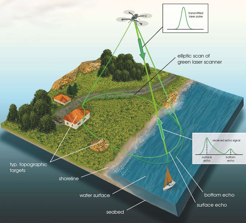
RIEGL VQ-880-G II
• for coastline and shallow water mapping
• visible green laser beam,
water penetration 1.5 Secchi depths
• infrared channel (optional) for detection
of the water surface
RIEGL VQ-880-GH
• optimized form factor
for helicopter
integration
www.riegl.com Copyright RIEGL Laser Measurement Systems GmbH © 2021 – All rights reserved. Innovation in 3DTopo-Bathymetric Airborne Laser Scanner
with Online Waveform Processing and Full Waveform Recording
RIEGL VQ-840-G
• compact and lightweight design
• visible green laser beam
• water penetration ≥ 2 Secchi depths
• high spatial resolution due to
measurement rate up to 200 kHz
and high scanning speed of up to 100 scans/sec
• integrated inertial navigation system (optional)
• high-resolution digital camera and IR laser rangefinder on request
• for installation on various platforms including UAVs
www.riegl.com Copyright RIEGL Laser Measurement Systems GmbH © 2021 – All rights reserved. Innovation in 3DRIEGL Helicopter Pod for Airborne Laser Scanning
• robust and reliable airborne scanner carrying platform
• full mechanical and electrical integration of sensor system components into aircraft fuselage
• quick installation & removal using the existing mounts (e.g. AirFILM Camera System);
mounting and operation at end user’s responsibility
• area exposed to wind approx. 0,114 m2
RIEGL VP-1 with RIEGL VUX-1
RIEGL VUX-1LR or VUX-1UAV LiDAR Sensor, IMU/GNSS unit
with antenna, control unit, and digital camera(s)
fully integrated
• total weight approx. 19 kg
NEW RIEGL VPX-1 with VUX-240
RIEGL VUX-240 LiDAR Sensor, control unit,
up to 3 Sony Alpha digital cameras and
a high-end IMU/GNSS system with antenna
fully integrated
• total weight approx. 20 kg
www.riegl.com Copyright RIEGL Laser Measurement Systems GmbH © 2021 – All rights reserved. Innovation in 3DMobile Scanning www.riegl.com Copyright RIEGL Laser Measurement Systems GmbH © 2021 – All rights reserved. Innovation in 3D
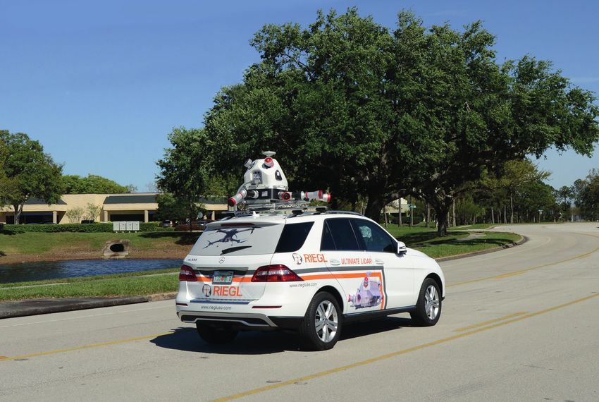
Mobile Laser Scanning
                                                                                        Mobile (Kinematic) Laser Scanning enables rapid and efficient data acquisition from a variety of
                                                                                        moving platforms, such as cars, railway vehicles, ships, boats, etc.

                                                                                        Mobile Laser Scanner
                                                                                        RIEGL VUX-1HA
                                                                                        •      compact, rugged, and lightweight design
                                                                                        •      easily mountable to whatsoever type of moving platform
                                                                                        •      high accuracy of 5 mm
                                                                                        •      up to 1,000,000 meas./sec
                                                                                        •      extremely high measurement speed
                                                                                               (1 MHz PRR, 250 scans/sec)
                                                                                        •      360° Field of View

www.riegl.com   Copyright RIEGL Laser Measurement Systems GmbH © 2021 – All rights reserved.                                                                              Innovation in 3D
Mobile Mapping System
RIEGL VMX-2HA
High Speed, High Performance Dual Scanner Mobile Mapping System
• 2 RIEGL VUX-1HA laser scanners and high accuracy IMU/GNSS unit fully integrated
• up to 2 MHz effective measurement rate, up to 500 scan lines/sec
• 5 mm accuracy, 360° vertical field of view
• user-friendly mounting
• aerodynamically-shaped protective cover RIEGL VMX-2HA equipped with RIEGL VMX-2HA equipped with
• camera interface for up to 9 optional cameras FLIR Ladybug® 5+ camera RIEGL cameras
• flexible combination of different camera configurations
- high-sensitivity 5MP and 12MP RIEGL cameras
- spherical camera FLIR Ladybug® 5+
- DSLR camera such as Nikon D850 or Sony Alpha
RIEGL VMX-2HA-BC (Basic Configuration)
• weight and size reduced version focusing on high-end scanning performance
• with an optional spherical imaging system such as FLIR Ladybug® 5+ camera
www.riegl.com Copyright RIEGL Laser Measurement Systems GmbH © 2021 – All rights reserved. Innovation in 3DMobile Mapping System
RIEGL VMX-RAIL
Triple Scanner Mobile Mapping System
Specifically Designed for Track Mapping and Clearance Surveying
• rugged measuring-head for reliable long-term operation in harsh environments
equipped with 3 VUX-1HA laser scanners
• 3MHz pulse repetition rate and 750 lines/sec resulting in up to 7000 pts/m2 in 3m range
at 80 km/h platform speed
customized integration example
• enables the capture of the complete rail corridor, including catenary systems, rail heads,
and the complete periphery, even signs orthogonal to running direction
• optionally integrated camera system and open interfaces to various sensors
• data export to Third-Party Rail-Processing Software Packages
www.riegl.com Copyright RIEGL Laser Measurement Systems GmbH © 2021 – All rights reserved. Innovation in 3DMobile Mapping Systems
RIEGL VMZ
Hybrid Mobile Mapping System
• IMU/GNSS unit, fully integrated to support RIEGL VZ-400i or VZ-2000i scanners
for mobile (kinematic) data acquisition
• fast transition from tripod to mobile mount – high stability of boresight system calibration
• optional image data acquisition with fully integrated cameras
RIEGL VMQ-1HA
High Speed, Single Scanner Mobile Mapping System
RIEGL VMZ in action • 1 RIEGL VUX-1HA laser scanner and
IMU/GNSS unit fully integrated
• up to 1 MHz effective measurement rate
• up to 250 scan lines/sec
static scanning
• 360° vertical field of view
• camera interface for up to 4 optional cameras
• multiple swivel positions of the measuring head
easy mounting
www.riegl.com Copyright RIEGL Laser Measurement Systems GmbH © 2021 – All rights reserved. Innovation in 3DUnmanned Scanning www.riegl.com Copyright RIEGL Laser Measurement Systems GmbH © 2021 – All rights reserved. Innovation in 3D
Unmanned Laser Scanning
                                                                                   Laser scanning utilizing high-end unmanned airborne platforms provides the possibility to acquire data
                                                                                   in dangerous and / or hard-to-reach areas, while offering an excellent cost-to-benefit-ratio for
                                                                                   numerous applications, e.g. corridor mapping, forestry and mining.
                                                                                   LiDAR Sensors for Unmanned Aircraft
                                                                                   RIEGL VUX-1UAV                                RIEGL miniVUX-1 Series
                                                                                   •       3.5 kg / 7.7 lbs                      •   1.55 kg / 3.4 lbs
                                                                                   •       up to 500 kHz Laser PRR               •   accuracy 15 mm
                                                                                   •       accuracy 10 mm                        RIEGL miniVUX-1UAV
                                                                                   •       operating flight altitude             •   100 kHz Laser PRR
                                                                                           more than 1,000 ft                    •   range up to 330m @ ρ ≥ 80%
                                                                                                                                 RIEGL miniVUX-2UAV
                                                                                    RIEGL miniVUX-1DL                            200 kHz / 100 kHz Laser PRR selectable:
                                                                                    Downward-Looking                             • range @ 200 kHz: up to 280 m @ ρ ≥ 80%
                                                                                    • optimized design for                       • range @ 100 kHz: as given for miniVUX-1UAV
                                                                                      corridor mapping applications              NEW RIEGL miniVUX-3UAV
                                                                                    • 100 kHz Laser PRR
                                                                                                                                 300 kHz / 200 kHz / 100 kHz Laser PRR selectable:
                                                                                    • range up to 1050 m @ ρ ≥ 80%               • range up to 330 m @ ρ ≥ 80%
                                                                                                                                 • FoV: 120° @ 300 kHz, 180° @ 200 kHz, 360° @ 100 kHz

www.riegl.com   Copyright RIEGL Laser Measurement Systems GmbH © 2021 – All rights reserved.                                                                                    Innovation in 3D
www.riegl.com Copyright RIEGL Laser Measurement Systems GmbH © 2021 – All rights reserved. Innovation in 3D
NEW RIEGL VUX-120
The Ultimate UAV LiDAR Sensor for Corridor Mapping

•     NFB (Nadir/Forward/Backward) Scanning
      for unrivaled completeness of scan data even on
      vertical structures and narrow canyons
•     measurement rate up to 1,500,000 meas./sec
•     scan speed up to 400 lines/second
•     operating flight altitude up to 720m / 2,350 ft
•     field of view up to 100°
•     cutting edge RIEGL technology providing:
      - echo signal digitization
      - multiple target capability
      - online waveform processing
      - multiple-time-around processing
•     mechanical and electrical interface
      for optional INS/GNSS integration
•     interfaces for up to 2 external cameras
•     scan data storage on internal 1 TByte SSD Memory
•     removeable CFAST memory card up to 256 GB

    www.riegl.com   Copyright RIEGL Laser Measurement Systems GmbH © 2021 – All rights reserved.   Innovation in 3D
RIEGL VUX-240
Compact & Lightweight UAV Laser Scanner
• easily mountable to unmanned platforms (UAVs) or to helicopters,
gyrocopters, and other small manned aircrafts
• laser pulse repetition rate up to 1.8 MHz
• measurement rate up to 1,500,000 meas./sec
• scan speed up to 400 lines/second
• operating flight altitude up to 1,400m / 4,600 ft
• field of view up to 75°
• perfectly linear and parallel scan lines
• cutting edge RIEGL technology providing:
- echo signal digitization
- multiple target capability
- online waveform processing
- multiple-time-around processing
• mechanical and electrical interface
for optional INS/GNSS integration
• interfaces for up to 4 optional cameras
• scan data storage on internal 1 TByte SSD Memory
www.riegl.com Copyright RIEGL Laser Measurement Systems GmbH © 2021 – All rights reserved. Innovation in 3DLaser Scanning System for Unmanned Aircraft
RIEGL VUX-SYS
The RIEGL VUX-SYS is a complete laser scanning system of low weight
and compact size for flexible use in kinematic applications.
• fully integrated RIEGL LiDAR sensor
VUX-1UAV/VUX-1LR or VUX-240
• inertial measurement unit and GPS/GLONASS receiver integrated
• various mounting options for highly flexible installation
• optional camera integration
• dependent on scanner and IMU/GNSS unit used, the system can be used flexibly
for different applications (e.g., VUX-SYS with VUX-1 for both, RiCOPTER and VMQ)
RIEGL VUX-SYS installed in RiCOPTER
• RIEGL VUX-1UAV LiDAR sensor, IMU/GNSS unit,
RIEGL VUX-SYS mit VUX-1 LiDAR sensor for RiCOPTER
GNSS antenna, control unit, and 2 cameras fully integrated
• 10 mm accuracy
• up to 350,000 meas./sec, 230° field of view
www.riegl.com Copyright RIEGL Laser Measurement Systems GmbH © 2021 – All rights reserved. Innovation in 3DLaser Scanning System for Unmanned Aircraft
RIEGL miniVUX-SYS
The RIEGL miniVUX-SYS is a complete miniaturized & lightweight laser scanning system of low weight and compact size for flexible use in UAV-based applications on a
variety of UAV/UAS/RPAS.
• RIEGL miniVUX Series LiDAR sensor fully integrated • prepared for remote control via low-bandwidth data link
• different IMU/GNSS options available • prepared for interfacing with optional RGB camera(s) and thermal imaging sensor(s)
• various mounting options for highly flexible installation • Integration Kit 600 available for straight forward system integration
with selected multi-rotor UAV types
RIEGL miniVUX-SYS with APX-15 UAV RIEGL miniVUX-SYS with APX-20 UAV RIEGL Integration Kit 600
Delair DT26X fixed-wing integration example with RIEGL miniVUX-1UAV LiDAR sensor add-on to the miniVUX-SYS coming with shock-absorbing
RIEGL miniVUX-1DL LiDAR sensor equipped with APX-15 UAV equipped with APX-20 UAV mounting-kit, power supply module and cabling
www.riegl.com Copyright RIEGL Laser Measurement Systems GmbH © 2021 – All rights reserved. Innovation in 3DRemotely Piloted Aircraft Systems
equipped with RiCOPTERControl (RiCC) redundant flight control system developed and produced by RIEGL.
RiCOPTER
• high-performance X8 array foldable octocopter
• carbon fiber main frame, foldable propeller carrier arms, and shock-absorbing undercarriage RiCOPTER-M equipped RiCOPTER ready to take off
for stable flights, landings and comfortable transportation with ADS-B/Mode-S transponder
• MTOM (Maximum Take-Off Mass) 25 kg
• max. sensor payload up to 6.5 kg
• flight endurance 30 min
• versatile carrier platform:
- integration of various sensors possible, e.g. RIEGL VUX-SYS laser scanning system or
bathymetric depth finder BDF-1
RiCOPTER-M
• equipped with special aviation safety features and ADS-B/Mode-S transponder
• MTOM (Maximum Take-Off Mass) 40 kg
• max. sensor payload up to 15 kg
www.riegl.com Copyright RIEGL Laser Measurement Systems GmbH © 2021 – All rights reserved. Innovation in 3DUAV-based LiDAR Surveying System
for Hydrographic Applications
BathyCopter
• RiCOPTER equipped with Bathymetric Depth Finder RIEGL BDF-1
(comprising of tilt compensator, an IMU/GNSS unit with antenna, a control unit
and up to two external digital cameras) providing up to 1.5 Secchi depths measuring range
• ideally suited for generating profiles of inland water bodies
• floating support for safe water landing and take-off from water bodies
• excellent performance even at adverse conditions based on pre-detection averaging
• highly accurate, reliable and informative bathymetric data resulting
from RIEGL’s proprietary hydrographic waveform processing
www.riegl.com Copyright RIEGL Laser Measurement Systems GmbH © 2021 – All rights reserved. Innovation in 3DIndustrial Scanning www.riegl.com Copyright RIEGL Laser Measurement Systems GmbH © 2021 – All rights reserved. Innovation in 3D
Industrial Laser Scanning
                                                                            RIEGL offers powerful scanners and scanning solutions for various fields of industrial applications. All these
                                                                            are exceptionally compact, reliable, and provide highest performance and longevity even in harsh and
                                                                            demanding environments.

                                                                            Laser Scanners
                                                                            VZ-200
                                                                            •       3D laser scanner for process automation of stackers and reclaimers, measurement of stock piles and bulk material,
                                                                                    surveying and monitoring in topography and mining

                                                                            Protective Housings
                                                                            PH-VUX
                                                                            •       protective housing for RIEGL VUX-1 Series laser scanners
                                                                            •       hermetically-sealed, with thermo-electric coolers and forced-air cooling

                                                                            RIEGL PH-400i/2000i and RIEGL PH-4000/6000-SRH
                                                                            •       rugged and robust industrial protective housing for RIEGL V-Line Terrestrial Laser Scanners
                                                                            •       hermetically-sealed, with thermo-electric coolers and forced-air cooling
                                                                            •       industrial standard connectors and supply cables
                                                                            •       application-specific interface and software solutions

www.riegl.com   Copyright RIEGL Laser Measurement Systems GmbH © 2021 – All rights reserved.                                                                                           Innovation in 3D
RIEGL Software Packages www.riegl.com Copyright RIEGL Laser Measurement Systems GmbH © 2021 – All rights reserved. Innovation in 3D
RIEGL Software for TERRESTRIAL Scanning

  RiPANO                                                                                                RIEGL VZ-i Series App
  Explore your project and extract plots in your browser!                                               For Remote Scanner Control

  • for terrestrial scan data visualization                                                             •   connection to the scanner via local or remote access
                                                                                                        •   the graphical user interface (GUI) of the laser scanner
3D point cloud                                                                                              is mirrored on the screen of your device
                                                                                                        •   available on the App Store for iPhone, iPad,
                                                                                                            iPadtouch, and for Windows and
                                                                                                            Android devices in the RIEGL members area

                                                                                    orthogonal view
                                                                                    of 3D point cloud
                                                                                    created in RiPANO

www.riegl.com    Copyright RIEGL Laser Measurement Systems GmbH © 2021 – All rights reserved.                                                                         Innovation in 3D
RIEGL Software for TERRESTRIAL Scanning
NEW RIEGL Mining App
Slope Angle App,
Design Compare App and
Monitoring App are applicable with
RIEGL VZ-i Series Laser Scanners
• real-time data transfer to web browser
on every device, which is connected
to the mine network
• relevant, reliable and accurate
deliverables to make prompt and
appropriate decisions
www.riegl.com Copyright RIEGL Laser Measurement Systems GmbH © 2021 – All rights reserved. Innovation in 3DRIEGL Software for TERRESTRIAL and INDUSTRIAL Scanning RiSCAN PRO Efficient data acquisition and processing, “one touch” wizard for daily task automation, automatic targetless scandata registration, pointcloud filtering and coloring, RiPANO project publishing RiMINING optimizing and simplifying scan data registration and processing workflow for open pit mining, offering, e.g. automatic extraction of breaklines RiSOLVE „one touch“ solution for a rapid acquisition and registration of scan data and calibrated camera images by terrestrial RIEGL V-Line Laser Scanners, reduces field and post-processing time significantly GeoSysManager2.0 conversion of coordinates from one geodetic, coordinate reference system to another www.riegl.com Copyright RIEGL Laser Measurement Systems GmbH © 2021 – All rights reserved. Innovation in 3D
RIEGL Software for MOBILE and AIRBORNE Scanning

 RiACQUIRE                                                                                      RiHYDRO
data acquisition & online visualization                                                         software addon for commercial hydrographic and bathymetric surveying

 RiPROCESS                                                                                      RiPRECISION
 workflow control & data management                                                             Trajectory adjustments to register overlapping mobile/UAV based scan data
                                                                                                completely automatically, expediently, and rigorously
 GeoSysManager2.0                                                                               LIS Classification ALS
 conversion of coordinates from one geodetic,                                                   Pointcloud classification addon for airborne data
 coordinate reference system to another
 RiUNITE
 full waveform analysis of digitized echo signals, automated
 resolution of range ambiguities, coordinate transformation

 RDB COLORIZER
 Add pointcloud color information from imagery

 EXPORT MODULE
 Export pointcloud data to industry standard exchange formats, e.g LAS

www.riegl.com    Copyright RIEGL Laser Measurement Systems GmbH © 2021 – All rights reserved.                                                                      Innovation in 3D
Thank you
for your kind attention!
Copyright RIEGL Laser Measurement Systems GmbH © 2021 – All rights reserved.
Use of this presentation other than for personal purposes requires RIEGL’s written consent.
The presentation is compiled with care. However, errors cannot be fully excluded and alternations might be necessary.
RIEGL Company Presentation, 2021-02-22You can also read