Cummiskey Farm We are pleased to present - Wingert Realty
←
→
Page content transcription
If your browser does not render page correctly, please read the page content below

We are pleased to present
                       Cummiskey Farm
              80 ± Acres Farmland & Hunting/Rec.
                    Kilkenny Township, Le Sueur County

    SUBJ
        ECT
              PRO
                 PERT
                      Y

                          For sale at $260,000.00
       View drone video at www.WingertRealty.com

Listing Agent: Darrell Hylen, ALC
Office: 507-345-LAND (5263)
Toll Free: 800-730-LAND (5263)
Direct: 507-381-3843
Auctioneer #07-18-01
Darrell.Hylen@WingertRealty.com
www.WingertRealty.com
State Highway Map

                      Minneapolis

SU
  BJE
     CT
          PR
            OP
               ER
                 TY

          Mankato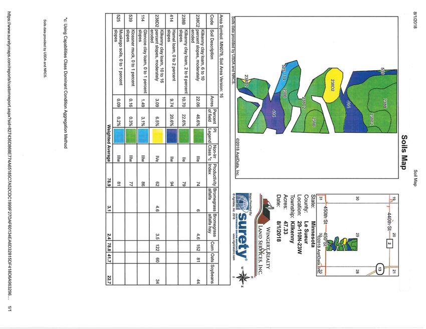
Le Sueur County
   Minnesota

                  SUBJECT PROPERTY
Killkenny Township
 Le Sueur County

           OPERTY
 SUBJECT PR
FSA Aerial View
Orange line is approximate property line.
Y
United States RT
PE
Farm 8210
Department of
Agriculture Le Sueur County, Minnesota O
PR
T
29 EC Tract 24265
T110 R23 BJ
Kilkenny
SU
12 1.58 2018 Program Year
Map Created May 11, 2018
0 175 350 700
Feet
Unless otherwise noted:
Shares are 100% operator
11 Crops are non-irrigated
0.71 Corn = yellow for grain
Soybeans = common soybeans for grain
Wheat = HRS, HRW = Grain
4 Sunflower = Oil, Non-Oil = Grain
0.56 Oats and Barley = Spring for grain
10
1.2 Rye = for grain
1 Peas = process
122.29 3 5.7 Alfalfa, Mixed Forage AGM, GMA, IGS = for forage
HEL Beans = Dry Edible
NAG = for GZ
8
Canola = Spring for seed
0.21 6
0.95
9 Common Land Unit
0.57 Non_Cropland
5
0.81
Cropland
2 23.94 Tract Boundary
PLSS
7
1.02
Wetland Determination
Identifiers
- Restricted Use
&
Limited Restrictions
*
#
28 Exempt from Conservation
T110 R23 )
"
²
Compliance Provisions
Kilkenny
44 55 00 tt hh S
S tt Tract Cropland Total: 122.29 acres
United States Department of Agriculture (USDA) Farm Service Agency (FSA) maps are for FSA Program administration only. This map does not represent a legal survey or reflect actual ownership; rather it depicts the information provided directly
from the producer and/or National Agricultural Imagery Program (NAIP) imagery. The producer accepts the data 'as is' and assumes all risks associated with its use. USDA-FSA assumes no responsibility for actual or consequential damage
incurred as a result of any user's reliance on this data outside FSA Programs. Wetland identifiers do not represent the size, shape, or specific determination of the area. Refer to your original determination (CPA-026 and attached maps) for exact
boundaries and determinations or contact USDA Natural Resources Conservation Service (NRCS). This map displays the 2017 NAIP Imagery.
Property Information
 DESCRIPTION:                                 80 ± Acres. West half of SE¼. Section 29, T110N-R23W
                                              (not to be used on legal documents)
                                              (Killkenny Township, LeSueur County, Minnesota)

 TAX PID #:                                   R06.029.5000 (160 ± ac) New PID # for 2019: R06.029.5010 (80 ± ac)

 BUILDINGS:                                   Windmill to be removed by seller (not part of sale). Possible well on property.

 REAL ESTATE TAXES:                           2018 Ag Hmstd taxes (160 ± ac)                           = $3,148.00
                                              Special Assessments-Ditch #38                            = $ 32.18

 FSA INFORMATION:                             Total acres                             = 80            ± acres
                                              *FSA Tillable acres                     = 47            ± acres
                                              *Corn base acres                        = 42.3          ± acres
                                              Corn PLC Yield                          = 168           ± bushels
                                              *Wheat base acres                       = 4.4           ± acres
                                              Wheat PLC Yield                         = 43            ± bushels
                                              2014-2018 Farm Program Info - Enrolled into Agricultural Risk Coverage
                                                      (ARC) County
                                              *Estimated acres. This tract is being split from a larger tract. FSA will
                                              recalculate tillable and base acres after sale.

 SOIL DESCRIPTION:                            Kilkenny, Hamel, Glencoe, Klossner, Muskego. See Soils Map.

 CPI:                                         Crop Productivity Index = 78.9

 TOPOGRAPHY:                                  Level to rolling

 NRCS CLASSIFICATIONS
 ON TILLABLE ACRES: Exempt from conservation compliance provisions.
                    HEL - Highly Erodible Land

WINGERT REALTY & LAND SERVICES, INC. stipulates that they are representing the seller exclusively in this transaction.

The information gathered for this brochure in its entirety is from sources deemed reliable, but cannot be guaranteed by Seller, Wingert Realty & Land
Services, Inc., or its staff. Package is subject to prior sale, price change, correction or withdrawal. The buyer must make their own independent investigation
of the property. The buyer is purchasing the property “as is”.
Property Photos

Looking north from 450th St.

Looking northeast from 450th St.

                                                     Photos taken 9/2018
Property Photos

Looking northwest from 450th St.

Looking west from 450th St.

Soils Map
Soil Descriptions
KILKENNY SERIES - Soil # 238C2, 238B, 238D2
                                                                     GEOGRAPHIC SETTING: Hamel soils have concave
The Kilkenny series consists of very deep, moderately well           slopes in swales, rims of closed depressions, foot and toe
drained soils that formed in a mantle of clayey glacial till or      slopes, and upper drainageways below sloping to very steep
flow till and underlying loamy glacial till on moraines. These       slopes. Slope gradients are 0 to 4 percent. Hamel soils
soils have moderately slow permeability. Their slopes range          formed in slope colluvium and glacial till of Late Wisconsinan
from 2 to 35 percent. The mean annual precipitation is about         Age. Mean annual temperature is about 45 to 48 degrees F.
28 inches. Mean annual temperature is about 48 degrees F.            Mean annual precipitation is about 25 to 30 inches. Frost free
                                                                     days range from 125 to 165. Elevation above sea level ranges
TYPICAL PEDON: Kilkenny loam with a 15 percent linear                from 700 to 1600 feet.
sideslope on a glacial moraine in a pastured field.
                                                                     GEOGRAPHICALLY ASSOCIATED SOILS: These are
GEOGRAPHIC SETTING: Kilkenny soils have plane and                    principally the Hayden and Lester soils. These soils are well
convex slopes on gently sloping to steep end moraines of the         drained and are on the higher lying, gently sloping to very
Des Moines lobe of the Late Wisconsinan glaciation. Their            steep slopes.
slopes range from 2 to 35 percent. They formed in a mantle of
clayey glacial till or flow till and underlying loamy glacial till   DRAINAGE AND PERMEABILITY: Poorly drained.
on moraines. Mean annual temperature ranges from 45 to 52            Surface runoff is low or moderately low. Permeability is mod-
degrees F. Mean annual precipitation is about 25 to 32 inches.       erately slow. The apparent seasonal high water table is at .5 to
Frost-free days range from 145 to 175. Elevation above sea           1.5 feet during November to June in most years.
level ranges from 800 to 1500 feet.                                  GLENCOE SERIES - Soil # 114

GEOGRAPHICALLY ASSOCIATED SOILS: These are                           The Glencoe series consists of very deep, very poorly drained
the Glencoe, Lerdal, Lester, Le Sueur, Lura, Mazaska, and            soils that formed in loamy sediments from glacial till on
Shields series. The very poorly drained Glencoe and Lura             glacial moraines. These soils have moderate or moderately
soils are in the lower lying drainageways and depressions. The       slow permeability. Slopes are 0 to 1 percent. Mean annual
somewhat poorly drained Lerdal soils are on gently sloping to        precipitation is about 28 inches. Mean annual temperature is
moderately steep areas. Shields soils are poorly drained, and        about 48 degrees F.
are on slightly elevated flats. Mazaska soils are poorly drained,
and are on slightly elevated flats and swales above or within        TYPICAL PEDON: Glencoe clay loam with a concave slope
areas of Kilkenny soils. Also, the well drained Lester soils and     of less than 1 percent in a depression on a ground moraine in
the moderately well drained Le Sueur soils are associated in a       cultivated field.
few areas.
                                                                     GEOGRAPHIC SETTING: Glencoe soils typically are
DRAINAGE AND PERMEABILITY: Moderately well                           in closed depressions or low gradient swales within the Des
drained. Permeability is moderately slow. Runoff is medium           Moines lobe of the Late Wisconsinan glaciation. The Glen-
or rapid. A perched seasonal high water table occurs at depths       coe soils are formed in loamy alluvial sediments and loamy
of 2.5 to 3.5 feet during the period November to June in most        glacial till. Mean annual temperature ranges from 45 to 52
years.                                                               degrees F. Mean annual precipitation ranges from 25 to 32
                                                                     inches. The frost free days range from 124 to 172. The eleva-
                                                                     tion above sea level range from 700 to 1600 feet.
HAMEL SERIES - Soil # 414
                                                                     GEOGRAPHICALLY ASSOCIATED SOILS: These are
The Hamel series consists of very deep, poorly drained soils         the Canisteo, Clarion, Harps, Nicollet, and Webster soils. The
that formed in slope colluvium and glacial till on moraines.         well drained Clarion soils are on the sloping uplands. Some-
These soils have moderately slow permeability. Their slopes          what poorly drained Nicollet and the poorly drained Can-
range from 0 to 4 percent. Mean annual precipitation is about        isteo, Webster, and Harps soils are on nearly level to gently
28 inches. Mean annual temperature is about 47 degrees F.            undulating slopes. All the above have mollic epipedons less
                                                                     than 24 inches thick. In addition, the Canisteo and Harps
TYPICAL PEDON: Hamel loam with a 2 percent concave                   soils contain free carbonates throughout. The Glencoe soils
slope on a glacial moraine in a cultivated field.                    also are associated with the Hayden and Lester soils and their
Soil Descriptions
respective topographic associates in some places. permeability in the coprogenous material. Slopes range from
0 to 2 percent. Mean annual precipitation is about 30 inches
DRAINAGE AND PERMEABILITY: Very poorly drained. near the typical pedon site. Mean annual temperature is about
Surface runoff is very slow or ponded. Permeability is moder- 49 degrees F.
ate or moderately slow.
typical pedon site. Mean annual temperature is about 49
degrees F.
KLOSSNER SERIES - Soil # 539
TAXONOMIC CLASS: Coprogenous, euic, mesic Limnic
The Klossner series consists of very deep, very poorly drained Medisaprists
soils formed in well decomposed organic material 16 to 50
inches thick overlying loamy deposits on moraines, till plains, TYPICAL PEDON: Muskego muck - on a slope of less than
lake plains, outwash plains, flood plains, and hillside seep areas. 1 percent in a cultivated field at an elevation of about 815 feet.
They have moderately slow to moderately rapid permeability
in the organic material, and moderate or moderately slow GEOGRAPHIC SETTING: The Muskego soils commonly
permeability in the loamy material. Slopes range from 0 to 8 are in depressional areas principally associated with glacial
percent. Mean annual precipitation is about 28 inches. Mean lake plains and flood plains, but other geographical locations
annual temperature is about 47 degrees F. are not excluded. Slope ranges from 0 to 2 percent. These
soils formed in herbaceous organic material dominantly from
TYPICAL PEDON: Klossner muck - with a 1 percent slope grasses, sedges, and reeds over coprogenous limnic material
in a cultivated field. (sedimentary peat). Mean annual temperature ranges from 46
to 52 degrees F. Mean annual precipitation ranges from 25 to
GEOGRAPHIC SETTING: Klossner soils are in basins 40 inches. The frost free period ranges from about 130 to 160
that were formerly lakes or ponds, lake plains, till plains, flood days. Elevation ranges from 800 to 1400 feet.
plains, outwash plains, or moraines. They are also on hillside
seep areas in moraines and sideslopes of river valleys. Slopes GEOGRAPHICALLY ASSOCIATED SOILS: These
range from 0 to 8 percent. The soils on nearby uplands are are the Houghton and Klossner series. Houghton soils are
generally loamy. The mean annual temperature ranges from in nearby areas where the organic deposits are more than 51
45 to 50 degrees F. The mean annual precipitation ranges inches thick and coprogenous material is not in the lower part
from 24 to 32 inches. Frost free days range from 110 to 160. of the control section. Klossner soils are in areas where the
Elevations above sea level range from 800 to 1400 feet. coprogenous material is absent and the herbaceous organic
material is underlain by loamy mineral material.
GEOGRAPHICALLY ASSOCIATED SOILS: The main
ones are the Canisteo, Harps, Okoboji, Glencoe, Muskego and DRAINAGE AND PERMEABILITY: Very poorly
Houghton soils. Canisteo and Harps soils are on the rims of drained. Runoff is very low or ponded. Permeability is moder-
depressions. Glencoe and Okoboji are at the outer edges of ate or moderately rapid in the herbaceous sapric material and
the depressions. Muskego and Houghton soils are in larger slow in the coprogenous material (sedimentary peat). Most
depressions. Muskego soils have an apparent water table from 1 foot above
the surface to 1 foot below the surface in most years for much
DRAINAGE AND PERMEABILITY: Very poorly drained. of the period from November to August. Some Muskego soils
Surface runoff is very slow or ponded. Permeability is mod- have an apparent water table from 3 feet to 1 foot above the
erately slow to moderately rapid in the organic layers and surface in most years for much of the period from January to
moderate or moderately slow in the loamy material. December.
MUSKEGO SERIES - Soil # 525
The Muskego series consists of very deep, very poorly drained
soils formed in herbaceous organic material over coprogenous
limnic material (sedimentary peat) on glacial lake plains and
flood plains. These soils have moderate or moderately rapid
permeability in the herbaceous organic material and slowThank You ... ... for the opportunity to present this property to you. We hope you found the information complete and the property of interest. However, if this property doesn’t meet your needs, please let us know. We will do our best to find one which satisfies your requirements. Also, if you feel you have no interest in this property, please pass this package along to a friend or associate who might have an interest.
Additional Notes
WINGERT REALTY & LAND SERVICES, INC.
                 Serving Minnesota and Northern Iowa
       Mankato Office: Toll Free 800-730-LAND (5263) • Local 507-345-LAND (5263)
                               www.WingertRealty.com

                CHARLES WINGERT, ALC                           DARRELL HYLEN, ALC
                PAST NATIONAL PRESIDENT OF                     Real Estate Sales & Lease Negotiation
                REALTORS LAND INSTITUTE (2013)                 Direct Line: 507-381-3843
                Broker                                         Darrell.Hylen@WingertRealty.com
                Direct Line: 507-381-9790
                Charles@WingertRealty.com

                                                               Auctioneer # 07-18-01

                Auctioneer # 07-17-14
                                                 Redwood Falls Office: 507-637-8178
                DAVID HANSON                              RICHARD HAUGE, ALC & ARA
                Real Estate Sales                              Real Estate Sales & Appraisals
                Direct Line: 507-525-7510                      Direct Line: 507-829-5227
                David@WingertRealty.com                        Rick@WingertRealty.com
                Auctioneer # 07-18-06

                                                               Auctioneer # 64-002

                                                  ALL ARE LICENSED
                                                  MN REALTORS®

             THE LAND REPORT, the magazine of the American Landowner, has named
                           Wingert Realty & Land Services, Inc.
                         “America’s Best Brokerages” 2010-2016 and
                       “Top Auction Houses” 2011-2016 in the U.S.A.!

10/4
You can also read