Declassified U2 spy plane images reveal bygone Middle Eastern archaeological features - Phys.org
←
→
Page content transcription
If your browser does not render page correctly, please read the page content below
Declassified U2 spy plane images reveal
bygone Middle Eastern archaeological
features
8 April 2019
CHESS by the U.S. government—remained
classified. And even when they became public in
1997, they weren't indexed or scanned.
Until now, the majority of this kind of historical
aerial documentation came from the CORONA spy
satellite program, which the U.S. ran between 1959
and 1972. But only the highest-resolution CORONA
images, taken during the program's final five years,
are useful for most archaeological purposes. The
U2 photos are earlier and a higher resolution than
even the best CORONA images, offering the
chance to see historical features undecipherable by
CORONA or already gone by the time of those
missions.
Knowing the potential insight offered by the U2
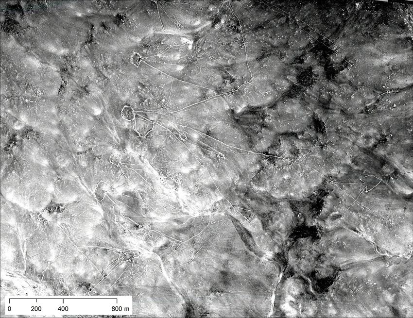
Desert kites, stone wall structures that date back 5,000 images, Hammer and Ur began sifting through the
to 8,000 years like those shown above, were used to materials. By analyzing thousands of high- and low-
trap gazelle and other similar animals. The dry desert of resolution frames, they discovered many historical
eastern Jordan preserved many of them, but agricultural and archeological features, including prehistoric
expansion in western Jordan dismantled or destroyed
hunting traps, 3,000-year-old irrigation canals, and
many more. Credit: University of Pennsylvania
60-year-old marsh villages no longer visible today.
The work, which they published in the journal
Advances in Archaeological Practice, represents
the first archaeological use of U2 spy plane
In the 1950s and early '60s, with the Cold War at
imagery—and a new and exciting window into
its peak, the United States flew U2 spy planes
history.
across Europe, the Middle East, and central
eastern Asia, taking images of interesting military
"The photos provide a fascinating look at the Middle
targets. Though the missions typically connected
East several decades ago, showing, for example,
Point A to Point B, say an air field and an important
historical Aleppo long before the massive
city, in many cases the camera kept recording
destruction wrought in the ongoing civil war," says
between those spots, capturing thousands of
Hammer, an assistant professor in Penn's Near
photos of the desert, steppes, fields, and villages
Eastern languages and civilizations department.
below.
"Plus, the work and the accompanying online
resources will allow other researchers to identify
Such a collection can represent a goldmine for
and access U2 photos for the first time."
landscape archaeologists like Emily Hammer of the
University of Pennsylvania and Jason Ur of
Hammer and Ur have both conducted research in
Harvard University. But for decades, all film and
the Middle East for decades, in Turkey, Azerbaijan,
documents from these missions—code-named
1/4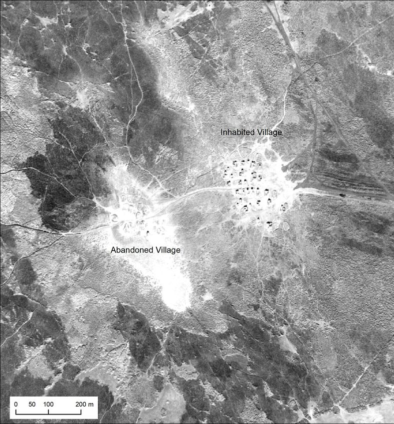
Iran, Iraq, and Syria. They've also both used        to select the film rolls they wanted moved from the
 CORONA spy satellite imagery extensively.            National Archives' storage center in Kansas to the
 However, many of those image sets didn't date        aerial film section in Maryland. Once there, the
 back as far as Hammer wished they would. "We         researchers unspooled hundreds of feet of film over
 knew that U2 spy planes must have taken              a light table to identify pertinent frames, then
 thousands of images across large parts of the        photographed the negatives in pieces using a
 Middle East, but there was no easy way to access 100-millimeter macro lens. Later, they stitched
 or reproduce the film negatives," she says.          together and adjusted each frame, before geo-
                                                      referencing the photos using GIS software to match
 A chance encounter with Lin Xu, a researcher who up images with coordinates of real-world places.
 had retrieved U2 images of his hometown in China,
 led Hammer and Ur to press on. "Seeing the           Despite the tedium of some of the individual tasks,
 amazing quality of those archival photos," Hammer the process excited Hammer. "As you turn the
 says, "we knew that it would be worth the detective spool of a film roll following the path of the U2
 work it would take to build a systematic index of    plane, you may not know exactly what you'll see in
 them."                                               unfamiliar places, so there's often a sense of
                                                      exploration and discovery," she says. "Other times,
                                                      the pilots were flying over regions I knew by heart
                                                      from travel and study, and I would almost hold my
                                                      breath, hoping that the plane had veered just a little
                                                      to the right or left."

                                                           The hours of work paid off, revealing many
                                                           important archaeological features, including
                                                           prehistoric hunting traps called desert kites in
                                                           eastern Jordan, an Assyrian canal system in
                                                           northern Iraq, and marshes in southern Iraq, case
                                                           studies the researchers highlighted in their paper.

                                                           Desert kites, stone-wall structures that date back
                                                           5,000 to 8,000 years, were used to trap gazelle and
                                                           other similar animals. The dry desert of eastern
                                                           Jordan preserved many of them, but agricultural
                                                           expansion in western Jordan dismantled or
                                                           destroyed many more. The satellite images bring
                                                           them back to life, showcasing a web of diamond-
                                                           shaped enclosures with what look like long kite
                                                           tails, offering the best view, to date, of these
                                                           important hunting tools.

The U2 images of southern Iraq present the layout, size,
                                                   The second feature, the canal system in northern
and environmental position of Marsh Arab communities in
                                                   Iraq, provides insight into how an early empire
the late 1950s and early 1960s, many of which
disappeared after massive hydroelectric dams       maintained its power and governed, Hammer
impounded the rivers, and after the government of  explains. "The Assyrians built the first large, long-
Saddam Hussein deliberately drained the marshes.   lasting, multi-cultural empire of the ancient world,
Credit: University of Pennsylvania                 so many people are interested in how they
                                                   organized territory, controlled people, built their
                                                   huge cities, and managed the land," she says. "The
                                                   irrigation system fed the royal capitals, made
It wasn't an easy process. Ahead of time, they had agricultural surplus production possible, and

                                                                                                         2/4
provided water to villages."

Finally, the U2 images of southern Iraq present the
layout, size, and environmental position of Marsh
Arab communities in the late 1950s and early
1960s, many of which disappeared after massive
hydroelectric dams in Turkey, Syria, and Iraq
impounded the rivers, and especially after the
government of Saddam Hussein deliberately
drained the marshes. Before that, "people lived a
unique lifestyle there for thousands of years,
herding water buffalo, building houses and all
manner of things out of reeds, living on floating
islands of reeds, planting date palms, and fishing,"
Hammer says. "Now we can study the spatial
organization, demography, and lifestyles of these
communities."

Though the three archaeological features represent
different historical time scales, going back
thousands of years or just decades, they all
demonstrate how humans are changing the natural
landscape, often in ways visible only from a
70,000-foot view.

Aerial images like those from the U2 spy missions
allow archaeologists like Hammer and Ur to travel
back in time. "The activities of ancient human
communities frequently left large-scale traces on
the landscape," Hammer says. "You can't see
these patterns when you're standing on top of
them, but just like stepping back from the blobs of
paint on an Impressionist painting reveals the full
picture, aerial and satellite imagery allow the
patterns to emerge."

 More information: Emily Hammer et al, Near
Eastern Landscapes and Declassified U2 Aerial
Imagery, Advances in Archaeological Practice
(2019). DOI: 10.1017/aap.2018.38

  Provided by University of Pennsylvania
APA citation: Declassified U2 spy plane images reveal bygone Middle Eastern archaeological features
(2019, April 8) retrieved 9 July 2019 from https://phys.org/news/2019-04-declassified-u2-spy-plane-
images.html

This document is subject to copyright. Apart from any fair dealing for the purpose of private study or research, no

                                                                                                             3/4
part may be reproduced without the written permission. The content is provided for information purposes only.
4/4
Powered by TCPDF (www.tcpdf.org)You can also read