Decoupling Design from Presentation: A Concept for Cloud-based Competition Submission and Judgement - gis.Point
←
→
Page content transcription
If your browser does not render page correctly, please read the page content below
302                                                                                             Full Paper

Decoupling Design from Presentation: A Concept for
Cloud-based Competition Submission and Judgement
Jörg Rekittke1, Philip Paar2
1Berlin   Megacity Laboratory/Germany · rekittke@email.de
2Laubwerk   GmbH, Berlin/Germany

Abstract: In our paper, we present a concept for a cloud-based landscape design submission and judge-
ment system. We are asking ourselves what would happen if all teams in a competition would do away
with their two-dimensional individual plan graphics and artwork, and concentrate on the intrinsic spatial
design act itself. Our concept can be understood as a competition-related interpretation of Michael
Flaxman’s definition of Geodesign (2010) – a design and planning method which tightly couples the
creation of design proposals with impact simulations informed by geographic contexts. Aim of the
concept is to achieve authoritative comparability of the qualities and performance of different design
proposals. It is about the neutralization of dispensable graphical effects for the sake of undraped design
quality and equitable comparability of design competition submissions. The proposed standardized cor-
set separates the design proposal from personal diction, but it still allows the presentation of different
designs in an attractive and beautiful way.
Keywords: Geodesign, landscape architecture competitions, cloud-based submission system, cloud-
based rendering, digital visualization

1      Introduction and Sources of Inspiration
In landscape design competitions, a considerable amount of time and effort is invested into
the creation of a convincing, two-dimensional graphical product, the specific submission.
The artistic thus individual expression of design intention is a merited driver for those who
participate in competitions and invest plenty of unpaid time. However, this long-established
practice tends to obscure comparability and the overall goal of competitions: Finding the best
solution for a site. Based on our own experience we may state that even the trained and canny
juror is subject to the effectiveness of visual tactics applied by versed design teams.
In this conceptual paper, we are trying to work through a Geodesign-inspired scenario where
all competing teams in landscape architecture competitions would do away with their indi-
vidual style of graphics, and artwork and concentrate on the plain spatial composition itself.
We scrutinize what would happen if all submitting parties would deliver merely undiluted
design parameters and configurations – bare design information –, but no own visualizations
or office-made mockups. The visualizations would then be generated in a consistent and eq-
uitable post-process.

1.1    Wood and Web
What we are calling for, is not new in architecture and urban design. All those local govern-
ments and planning authorities that invested in the construction and continuous maintenance
of physical mockups of their growing, sometimes shrinking cities, actively pursued the ob-
jective of comprehensible design judgement, testing, and determination. No matter if we take
Berlin, Boston, or Singapore as commendable examples (Figure 1), their models are based

Journal of Digital Landscape Architecture, 3-2018, pp. 302-309. © Wichmann Verlag, VDE VERLAG GMBH ·
Berlin · Offenbach. ISBN 978-3-87907-642-0, ISSN 2367-4253, e-ISSN 2511-624X, doi:10.14627/537642032.
This article is an open access article distributed under the terms and conditions of the Creative Commons
Attribution license (http://creativecommons.org/licenses/by-nd/4.0/).
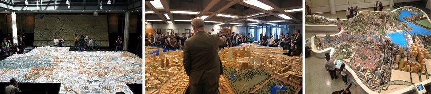
J. Rekittke, P. Paar: Decoupling Design from Presentation                                    303

upon certain common denominators. The models are used to study planning and development
options within the represented area. They also describe the city to visitors (BPDA 2018). Be-
sides showing urbanistic developments using overview models, more detailed model versions
also offer insights into architectural subtleties and effects buildings have on their surround-
ings (BERLIN SENATE DEPARTMENT FOR URBAN DEVELOPMENT AND HOUSING 2018). Rep-
resented structures are uniformly modeled according to specified guidelines and provide the
city authorities a standardized means for stewarding their built environment.

Fig. 1: Physical scale models of Berlin (left), Boston (mid), and Singapore (right)
        (Photos: Berlin Senate, BPDA, Wiki Commons)

The 1:500 scale 'Historic Centre' Berlin Model, with an area of 70 square meters, manages
on three different visual renditions. Building stock before 1990 is built in form of plain white
models, planned buildings are built as abstracted wooden structures, and new buildings since
1990 are built in form of detailed wooden models. Building and keeping current large phys-
ical city models is an expensive undertaking and requires professional model builders. All
effort and investment are categorically worth it, because the models turn out to be fascinating,
beautiful, and unbeatably descriptive. As a matter of course, the physical model has gotten
serious competition – in form of the reproducible, adjustable, storable digital counterpart.
In case of Berlin, besides its several physical city models of different time periods and scales,
the Senate Department for Urban Development and Housing makes digital two-dimensional
plans and three-dimensional models of the city center available online to all designers and
the public. There is also an online Berlin Building Atlas. It provides a detailed view of ap-
proximately 800 construction projects, which have been built since the Fall of the Wall.

1.2   ‘Barrier-free’ Spatial Portrayal
Chances are that there is no more apposite non-digital analogy for our concept, than the
1:2000 scale 'Talking Tactile Model of Berlin' (BERLIN SENATE DEPARTMENT FOR URBAN
DEVELOPMENT AND HOUSING 2018). Developed by the Faculty of Modelling and Design,
Institute of Architecture, TU Berlin, this experimental model allows visually impaired or
blind people to experience a representation of Berlin's inner city (Figure 2). The model is a
successful example of a conversion possibility (REICHINGER et al. 2012) of conventional
methods for the purpose of ‘barrier-free’ portrayal of urban architectural and landscape ar-
chitectural space. Users experience the model by touching the contours of the city model, and
over 150 points of interest can be explored acoustically or are explained through embossed
printing (BERLIN SENATE DEPARTMENT FOR URBAN DEVELOPMENT AND HOUSING 2018).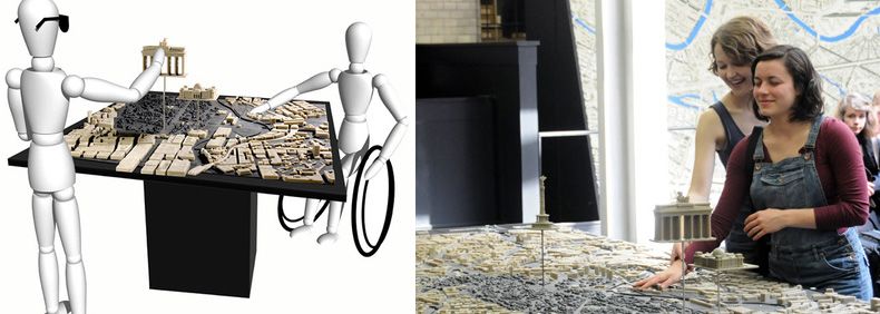
304                                            Journal of Digital Landscape Architecture · 3-2018

Fig. 2: 'Talking Tactile Model of Berlin', Berlin Senate Department for Urban Development
        and Housing (Photo: Philipp Eder 2013)

In our view, the Talking Tactile Model of Berlin demonstrates, in an unusual manner, that,
even if purposeful graphic is entirely replaced by non-visual methods of portrayal, the es-
sence – spatial recognition – still can be conveyed successfully. We don't advocate talking
and tactile models for design competition purposes, but the theoretical expendability of de-
ceptive artwork becomes noticeable. Figuratively barrier-free, equitable accessibility and as-
sessability of spatial information is an ambitious purpose, therefore we consider lateral think-
ing and tapping sources of inspiration to be important.

1.3   Online Submission Routine
Submitting material or information online, by now is a common routine in the context of any
professional or private occupation. For tasks that can be standardized, for example academic
assignments in computer programming, online coursework assessment systems are able to
collect submissions, perform automatic tests for correctness and quality, check for plagia-
rism, and provide an interface for marking and delivering feedback (JOY et al. 2005).

1.4   Separation of Content and Style
Separation of content and presentation, or separation of content and style, is a design princi-
ple under which the final visual editing of information is separated from the core content and
structure of a document. The principle is to be used in publishing, including Web design and
development, desktop publishing, content management (CLARK 2007), and also platforms
like OpenStreetMap (ARSANJANI et al. 2015). When writers and designers store their bare
design information – content – separately from the larger aesthetics of related documents or
products – style –, content and presentation can be linked in a flexible way. Alterations are
independently executable (CLARK 2007). When web designers follow the separation of con-
tent and style principle, the visual representation is not part of their HTML specifications but
is determined by the web browser and design templates such as CSS (Cascading Style
Sheets). Such separation improves content accessibility and provides control in the specifi-
cation of presentation characteristics.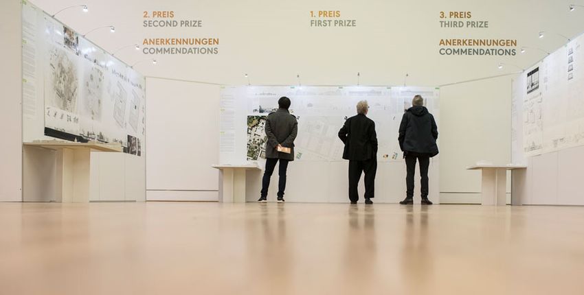
J. Rekittke, P. Paar: Decoupling Design from Presentation                                    305

Common products submitted for architectural, landscape architectural and urban design com-
petitions are, still, drawings, images, and physical models – plans and portrayals – individ-
ually generated with the help of CAD software, 3D renderers, Photoshop, et cetera (Figure
3).

Fig. 3: Exhibition of design competition results for 'The Museum of the 20th Century', Ber-
        lin, 2016, showing submitted plans and models (Photo: SPK/ photothek.net/ Florian
        Gaertner)

Such graphical and physical artefacts are supposed to represent and incorporate the design
content – the design as such. But the represented content is inseparably locked inside the
presented artefacts and cannot be unhinged for the purpose of independent comparison with,
likewise locked, content, generated by the competing teams. The problem is, that the proba-
bly intelligent content conceived by every design team, is transformed into 'stupid' graphical
products without extractable and comparable meta data or semantic data. Unfortunately, the
original scenes files remain at the local 'data cemetery' of each participating team.

1.5   Geodesign Fundamentals
Due to the above-mentioned dilemma of amalgamated design content and style, a look into
the field and processes of Geodesign is requisite. "Geodesign changes geography by design"
(STEINITZ 2012). It is a design and planning method which tightly couples the creation of a
design proposal with impact simulations informed by geographic context (FLAXMAN 2010).
When Flaxman formulated his Fundamentals of Geodesign, presented in 2009, published in
2010, he anticipated those inalienabilities that also our concept builds upon – a digital century
later. As three main concerns, Flaxman drafted 1) how the designers’ graphical skills could
be connected to computable and shareable semantic structure; 2) how static object inventories
could be avoided, and function and structure of complex systems could be represented; 3)
how professional representations might be structured in order to allow deeper and more sub-
stantive public participation. The canvas we paint is the earth, writes Flaxman – in times of
306 Journal of Digital Landscape Architecture · 3-2018 prevalent use of Google Earth and Google Maps, this metaphor gains in direct relevance. Today, every tourist permanently knows, to an accuracy of meters, their position on the globe. A fortiori, Flaxman's demand for georeferencing and semantics of professional design infor- mation, is cogent. Also, his demand for public accessibility of representations and increased participation is self-evident. Why should millions of television viewers be granted right to a say in pop music competitions like the Eurovision Song Contest (EUROVISION 2018), but a design competition for a neighborhood that is frequented by hundreds of thousands of people be judged by a jury of five or seven? The issue-free inclusion of TV viewers might also serve as a trivial example of technology-enabled but platform-neutral interaction – something Flax- man attributes to Geodesign as well. As a final point in our retrospect on Flaxman's funda- mentals, we like to mention his advocacy for material libraries and design system defaults. “If appropriate libraries can be provided, then it becomes considerably easier for a designer to generate even concept drawings with defaults allowing sensible preliminary evaluations. A materials palette can allow a designer to specify an attribute such as imperviousness indi- rectly, since this can be an attribute of the material” (FLAXMAN 2010). Only by the use of reproducible and collectively usable tools, including library items, can true comparability be warranted. Only reproducible laboratory conditions or test set-ups allow correct and equitable test results. This applies to ranked assessments like product tests and should – in principle – also apply to design competitions. An unambiguous example for the necessity of equal and equitable test conditions might be crash tests for cars. For the sales relevant test results, it is entirely irrelevant how the different tested cars look. The only thing that matters is if drivers and passengers, personified by crash test dummies, would be injured or killed – or not. 2 Future Workflow We were not in a position to produce an operational workflow for cloud-based submission and judgement. Instead, we tried to identify a hypothetical one. For an ideal (graphically) unbiased landscape design competition, each competing team starts by logging into a com- petition platform (server) provided by the initiators of the competition. They download the task description (brief), georeferenced photos, VR panoramas, and a georeferenced, semantic 3D model of the site inclusive its surroundings. The competitors will work with a version of their favorite desktop program such as Vectorworks Landscape, or – what seems conceivable – use a web- and cloud-based design platform, most probably very much conforming to a product like SketchUp Free 2018 (TRIMBLE 2018). The competition teams will either use specified libraries for materials, 3D objects, e. g. city furniture, as well as 3D plants and other components, or upload custom-designed objects, like their sui generis park bench, in a deter- mined format. The final submissions – inherently work in progress – describe the structure and configura- tion of the designs semantically, three-dimensionally, ideally also spatio-temporally, in an open standard format (e. g. Open BIM, CityGML), and will be uploaded to the competition server. The cloud-based platform hosts all entries and is used to procedurally generate visu- alizations from the submitted data (STOCK et al. 2005), enabling uniform and unequivocally comparable representations. The on-demand visualization service is used by all related par- ties, the design teams, the jury, and, as far as possible, the public. The visualization system produces 3D models, sections, plans, interactive walk-throughs – whatever form of spatial portrayal will be suitable and favored.
J. Rekittke, P. Paar: Decoupling Design from Presentation                                   307

Fig. 4: Example of a non-automatically yet ‘fast’ generated, walkable 3D phantasy (scene),
        created by use of the game engine Unreal 4 (Video: Maverick 2017)

The different design proposals can be interactively explored, critically examined, and put to
the acid test. We believe that a real-time game engine such as Unreal 4 (EPIC GAMES 2018),
which is free of charge for project visualizations, could take both the 2D and 3D visualization
of landscape design competition varieties to a new level, both technologically and aestheti-
cally. Significantly advanced since its first application within a participatory landscape plan-
ning process (HERWIG & PAAR 2002), the Unreal engine would by now enable on-demand
real-time display of complex 3D landscape scenes (Figure 4).
It also supports VR head-mounted displays for an immersive, full-scale first-person view –
possibilities that had to be categorized as future music a short while ago (PAAR & REKITTKE
2005). With the help of augmented reality applications and tools for seamless interaction
between physical and virtual locations, the different competition entries can be contrasted in
the lab as well as on site (CLERGEAUD et al. 2017). GRAHAM & HEWITT (2012) suggest the
need for a fully volumetric urbanism to address “the ways in which horizontal and vertical
extensions, imaginaries, materialities and lived practices intersect and mutually construct
each other”. We expect a much better assessability of design proposals when three-dimen-
sional characteristics and qualities of urban nature and greenspaces can be explored in 3D.
Furthermore, all uploaded design proposals will be vetted for suitability and impact by soft-
ware tapping the data stored on cloud-based servers (creating an online archive, e. g. acces-
sible for evaluation and comparison). An artless dashboard will inform about the detected
facts. Flailing arms of the creative and pointless juror's prose will be things of the past, one
day.
308 Journal of Digital Landscape Architecture · 3-2018 3 Conclusion and Outlook Digital visualization does not necessarily imply individual skills and personal style. In contrast to artistic and individualistic forms of expression like painting, drawing, sculpting, or pho- tography, digital visualization lends itself to be used as a rendition of services. Visualization, for the purpose of design competitions, doesn't have to be an independent pre-submission task, it can also be applied for a standardized, after-submission, on-demand postprocessing workflow. The purposeful decoupling of design content and individual artistic presentation in the frame of a spatial composition act (e. g. landscape architectural design operation), will play an important role in the overdue demystification of design competition graphics – in landscape architecture and beyond. If, for example, a specific view from a specific viewing point or course of movement plays a particular role and makes particular sense in the context of critical assessment of appearance or function, the exactly same perspective must be cap- turable for all submitted works in a design competition. Without the fulfillment of such banal feature, equitable judgement is impossible, and remains notional. As long as, for example, landscape functions like groundwater recharge rate remain unassessed by data- and server-based engines (software) before or during judgement, required merits like ecological value and sustainability will remain frustratingly empty words. Only software- controlled machines will be able to detect, calculate and display invisible ecosystem services performance to a satisfactory extent. The machines will be fed with increasingly large, struc- tured data packages of incremental complexity. Yet, as Carl Steinitz stated at the DLA con- ference in 2012: Size of data is not a problem, it is infinite. References ARSANJANI, J., ZIPF, A., MOONEY, P. & HELBICH, M. (2015), An Introduction to Open- StreetMap in GIScience: Experiences, Research, Applications. In: JOKAR ARSANJANI, J., ZIPF, A., MOONEY, P. & HELBICH, M. (Eds.), OpenStreetMap in GIScience: experiences, research, applications. Springer Press, 1-15. BERLIN SENATE DEPARTMENT FOR URBAN DEVELOPMENT AND HOUSING (2018), City Mod- els of Berlin. http://www.stadtentwicklung.berlin.de/planen/stadtmodelle/index_en.shtml (accessed 3 January, 2018). BOSTON PLANNING & DEVELOPMENT AGENCY [BPDA] (2018), The BPDA's model room. http://www.bostonplans.org/about-us/model-room (accessed 3 January, 2018). CLARK, D. (2007), Content Management and the Separation of Presentation and Content. Technical Communication Quarterly, 17 (1), 35-60. CLERGEAUD, D., ROO, J. S., HACHET, M. & PASCAL GUITTON, P. (2017), Towards Seamless Interaction between Physical and Virtual Locations for Asymmetric Collaboration. Vir- tual Reality Software and Technology 2017 – 23rd ACM Symposium on Virtual Reality Software and Technology, Nov 2017, Gothemburg, Sweden, 1-5. EPIC GAMES (2018), Unreal Engine 4. https://www.unrealengine.com (accessed 9 January, 2018). EUROVISION (2018), Eurovision Song Contest. https://eurovision.tv (accessed 7 January, 2018).
J. Rekittke, P. Paar: Decoupling Design from Presentation                              309

FLAXMAN, M. (2010), Fundamentals of Geodesign. In: Proceedings of Digital Landscape
   Architecture, Anhalt University of Applied Science, 28-41.
GRAHAM, S. & HEWITT, L. (2012), Getting off the ground: On the politics of urban vertical-
   ity. Progress in Human Geography, 37 (1), 72-92.
HERWIG, A. & PAAR, P. (2002), Game Engines: Tools for Landscape Visualization and Plan-
   ning? In: BUHMANN, E., NOTHELFER, U. & PIETSCH M. (Eds.), Trends in GIS and Virtu-
   alization in Environmental Planning and Design. Proc. at Anhalt University of Applied
   Sciences. Wichmann, Heidelberg, 162-171.
JOY, M., GRIFFITHS, N. & BOYATT, R., (2005), The BOSS Online Submission and Assess-
   ment System. Journal on Educational Resources in Computing, 5 (3), Article number 2.
PAAR, P. & REKITTKE, J. (2005), Lenné3D – Walk-Through Visualization of Planned Land-
   scapes. In: BISHOP, I. D. & LANGE, E. (Eds.), Visualization in landscape and environmen-
   tal planning. Taylor & Francis, London, 152-161.
REICHINGER, A., NEUMÜLLER M., RIST F., MAIERHOFER S. & PURGATHOFER W. (2012),
   Computer-Aided Design of Tactile Models. In: Miesenberger K., Karshmer A., Penaz P.,
   Zagler W. (Eds.), Computers Helping People with Special Needs. ICCHP 2012. Lecture
   Notes in Computer Science, Vol. 7383. Springer, Berlin/Heidelberg.
STEINITZ, C. (2012), A Framework for Geodesign: Changing Geography by Design. ESRI
   Press, Redlands, CA.
STOCK, C., BISHOP, I. & O’CONNOR, A. (2005), Generating Virtual Environments by Linking
   Spatial Data Processing with a Gaming Engine. In: BUHMANN, E., PAAR, P., BISHOP, I.,
   LANGE, E. (Eds.), Trends in Real-Time Landscape Visualization and Participation, Pro-
   ceedings at Anhalt University of Applied Sciences 2005. Wichmann, Heidelberg.
TRIMBLE INC. (2018), SketchUp Free 2018.
   https://www.sketchup.com (accessed 9 January, 2018).
You can also read