Developing and testing a street audit tool using Google Street View to measure environmental supportiveness for physical activity
←
→
Page content transcription
If your browser does not render page correctly, please read the page content below
Griew et al. International Journal of Behavioral Nutrition and Physical Activity 2013, 10:103
http://www.ijbnpa.org/content/10/1/103
RESEARCH Open Access
Developing and testing a street audit tool using
Google Street View to measure environmental
supportiveness for physical activity
Pippa Griew1, Melvyn Hillsdon1*, Charlie Foster2, Emma Coombes3, Andy Jones3 and Paul Wilkinson4
Abstract
Background: Walking for physical activity is associated with substantial health benefits for adults. Increasingly
research has focused on associations between walking behaviours and neighbourhood environments including
street characteristics such as pavement availability and aesthetics. Nevertheless, objective assessment of street-level
data is challenging. This research investigates the reliability of a new street characteristic audit tool designed for use
with Google Street View, and assesses levels of agreement between computer-based and on-site auditing.
Methods: The Forty Area STudy street VIEW (FASTVIEW) tool, a Google Street View based audit tool, was developed
incorporating nine categories of street characteristics. Using the tool, desk-based audits were conducted by trained
researchers across one large UK town during 2011. Both inter and intra-rater reliability were assessed. On-site street
audits were also completed to test the criterion validity of the method. All reliability scores were assessed by
percentage agreement and the kappa statistic.
Results: Within-rater agreement was high for each category of street characteristic (range: 66.7%-90.0%) and good
to high between raters (range: 51.3%-89.1%). A high level of agreement was found between the Google Street View
audits and those conducted in-person across the nine categories examined (range: 75.0%-96.7%).
Conclusion: The audit tool was found to provide a reliable and valid measure of street characteristics. The use of
Google Street View to capture street characteristic data is recommended as an efficient method that could
substantially increase potential for large-scale objective data collection.
Keywords: Physical activity, Walking, Environment, Street audit
Introduction environmental variables provides a substantial research
Walking is widely promoted as an effective form of challenge. Mapping technologies, such as Geographical
physical activity associated with wide ranging health Information Systems (GIS), have increased access to ob-
benefits for adults [1]. Current UK guidelines recom- jectively characterised data on neighbourhood design
mend that adults complete at least 150 minutes of mod- and land-use. These data are now regularly utilised in
erate intensity activity, such as brisk walking, every week physical activity research and significant associations
[2]. Nevertheless, the English National Travel Survey have been found between walking behaviours and land-
2010 reports that walking trips have declined by 28% use mix, population density and destination proximity
since 1995 [3]. [5]. Detailed street-level characteristics such as pavement
Ecological models of health behaviour suggest that quality, lighting and aesthetics may additionally be influ-
environments such as residential neighbourhoods can ential. Indeed, walking for both travel and leisure have
directly influence physical activity behaviours including been significantly associated with individuals’ percep-
walking [4]. However, the objective measurement of tions of the availability of pavements [6,7] and aesthetics
[8]. Objectively measured street-level data, however, are
* Correspondence: m.hillsdon@exeter.ac.uk
rarely available through mapping databases [9].
1
Sport and Health Sciences, University of Exeter, Exeter, UK
Full list of author information is available at the end of the article
© 2013 Griew et al.; licensee BioMed Central Ltd. This is an Open Access article distributed under the terms of the Creative
Commons Attribution License (http://creativecommons.org/licenses/by/2.0), which permits unrestricted use, distribution, and
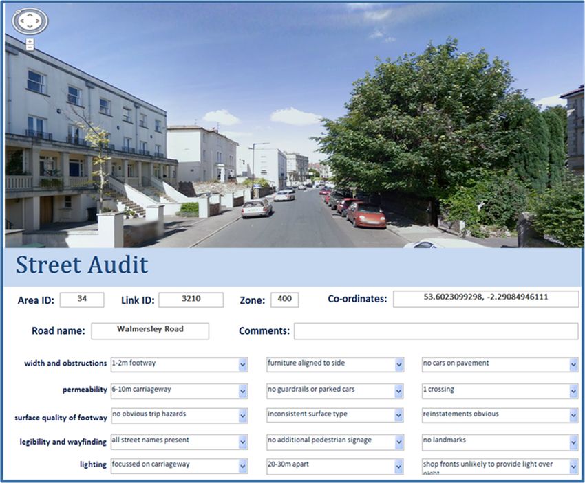
reproduction in any medium, provided the original work is properly cited.Griew et al. International Journal of Behavioral Nutrition and Physical Activity 2013, 10:103 Page 2 of 7 http://www.ijbnpa.org/content/10/1/103 A number of street audit tools such as the Systematic Methods Pedestrian And Cycling Environment Scan tool Street audit tool development SPACES [10], the Pedestrian Environment Review Sys- The FASTVIEW audit tool was created in collaboration tem (www.trl.co.uk) and the Residential Environment with the UK Transport Research Laboratory (TRL). The Assessment Tool REAT [11] are available to measure audit tool was based on the Pedestrian Environment Re- the street characteristics hypothesised to influence view System (PERS) initially designed by TRL to identify walking behaviours. Such audit tools are completed in- target areas for improving pedestrian access within person by trained researchers and are typically found London and the rest of the UK (www.trl.co.uk). PERS to provide a valid and reliable measure [10,11]. How- and FASTVIEW have different aims and therefore modi- ever, in-person audits are highly time-consuming, have fications to the original PERS were made to reduce the safety issues for personnel and are costly due to the re- subjective elements of the tool and to take into account lated travel expenditure, thus prohibiting large-scale current academic evidence and the expert opinion of the data collection for the majority of research projects. FAST steering committee. For example, an assessment Recent technological advancements, such as the Goo- of the housing design and ‘feel’ of a street was replaced gle Street View programme (www.google.com/maps), with an assessment of housing and street maintenance might provide an alternative mechanism to traditional where auditors were asked to assess factors such as in-person street auditing. Google Street View is a freely levels of graffiti and litter. The final FASTVIEW tool in- available web service using video stills of streets and corporated nine categories of neighbourhood character- neighbourhoods captured worldwide. The images are istics (e.g. pavement quality, lighting and safety) with displayed to provide continuous panoramic street each category including up to three separate factors (e.g. views that can be navigated along and rotated by 360° pavement width and spacing of street lights) as displayed allowing the user to virtually walk down any available in Table 1. Each factor had a number of levels that it street from their computer. The use of this desk-based was rated on. In Table 1 the levels are listed in the third tool, therefore, has the potential to dramatically reduce column and are ordered from more positive through to the resources necessary to complete large-scale assess- more negative (researchers wanting access to the tool ment of street characteristics. should contact the corresponding author). The reliability of desk-based auditing has previously A data input form was created using Microsoft Access been investigated by a small number of studies all of with drop down menu options for all responses. The which consistently report high levels of agreement be- form was designed to be viewed alongside Google Street tween Google Street View and in-person measures View using a computer split screen (Figure 1). Prior to [12-14]. Nevertheless, to date, the majority of this re- data collection all auditors completed a one-day training search has focused on somewhat homogenous urban course with an experienced auditor from TRL and were areas within the US. Further research is therefore neces- provided with a detailed user manual for reference dur- sary to assess the appropriateness of Google Street View ing auditing. For each link both sides of the road were in differing countries and area types where factors such audited. When a road had a pavement on one side only as varying road and pavement width or traffic and build- the side with the pavement was audited. For pavement ing density could potentially impact upon the reliability width and street lighting spacing the distance measure- of the measurement tool. ment tool in Google Street View was used. A guideline This study aims to first, test the inter-rater and intra- of 10–15 minutes completion time was suggested for rater reliability of a newly developed street audit tool each street audit. Both Google Street View and on-street designed specifically for use with Google Street View audits took approximately 10 minutes to complete. and, second, to test the reliability of this desk-based measure when compared with on-foot street audits Sampling across a range of land-use types within the UK. This Wigan, a large UK town in the North West of England research forms part of the FAST study (Forty Area was chosen to test the reliability of the FASTVIEW audit STudy). FAST is examining the degree to which built tool due to the large diversity of land-use types (includ- environment characteristics influence adult’s physical ing housing, shopping, parkland and industrial areas) activity behaviours across a broad range of social and close to the town centre. The population weighted cen- environmental settings in northwest England. In FAST, troid for the town was located using a Geographical In- we are particularly interested in capturing aspects of formation System (GIS) and the audit area was defined the street environment around our participants’ homes by an 800 m radius (approximately a 10 minute walk) that may influence their walking and cycling behav- around this centre point (Figure 2). The road network iours, and the street audit tool that we present in this within the study area was mapped in the GIS and di- paper, was developed for this purpose. vided into road sections termed ‘links’. Where possible
Griew et al. International Journal of Behavioral Nutrition and Physical Activity 2013, 10:103                                                 Page 3 of 7
http://www.ijbnpa.org/content/10/1/103

Table 1 Walkability categories within the audit tool
Category                      Factors                                      Levels
Pavement width and            Pavement width (metres)                      >3; 2–3; 1–2; 50% of crossings; 50% of crossings; 50% of crossings; 50% of crossings; 50%; 50%; 50; N/A
                              Likelihood of overnight lighting from        Shop fronts likely to provide light; not likely
                              nearby buildings
Personal security             Evidence of vandalism or graffiti            No evidence; some evidence
                              Presence of closed circuit television        Yes; No
                              surveillance
                              Informal surveillance from nearby housing    Yes; No
User conflict                 Obstruction from bus queues                  Yes; No
                              Separation between cyclists and              Yes; No
                              pedestrians
                              Presence of traffic calming measures         Yes; No
Environment quality           Quality of housing                           High quality frontages; low quality frontages
                              Presence of trees                            Yes; No
                              Street maintenance                           Clean and well maintained; some litter; some litter and graffiti
* N/A, Not Applicable because there was no pavement.

these links stretched between road junctions, however in                     combined results from the associated factors. For ex-
the case of long roads that had few junctions we aimed                       ample a street with wide pavements (>3 m), street furni-
to maintain homogeneity within links by setting the                          ture (e.g. benches and lighting) aligned to the side of the
maximum link length at 300 metres thus minimising the                        pavement, and with no cars parking on the pavement
potential for links to straddle different land uses. Conse-                  would get the highest score (2) in the pavement width
quently long stretches of road were split into a series of                   and obstructions category (see Table 1). In general, if the
links no longer than 300 metres in length. Similarly the                     levels of each category were consistently positive then
minimum link length was set at 50 metres. A total of                         the category would be rated as good and if they were
216 eligible audit links were identified within the study                    consistently negative the category would be rated as
area, of these 25% (n = 54) were randomly selected for                       poor. If the levels were neither consistently good nor
auditing based on recommendations [15]. The 54 links                         poor then the category was rated as fair.
equated to 5.36 kilometres of road network.                                    The kappa statistic was chosen for the reliability ana-
                                                                             lysis as it provides a chance-corrected measure of agree-
Data reduction and analysis                                                  ment suitable for use with categorical data. However,
Each street link was rated as ‘good’ (2), ‘fair’ (1) or ‘poor’               a recognised limitation of the kappa statistic is that a
(0) in each of the nine walkability categories based on                      low kappa co-efficient can be recorded despite high
Griew et al. International Journal of Behavioral Nutrition and Physical Activity 2013, 10:103 Page 4 of 7
http://www.ijbnpa.org/content/10/1/103
Figure 1 FASTVIEW audit tool.
levels of observed agreement dependent upon the preva- Inter-rater reliability
lence of agreement [16]. Thus results here report and To assess the level of agreement between researchers all
discuss the percentage of observed agreement in three auditors completed desk based street audits using
conjunction with the calculated kappa co-efficient. Google Street View for all of the area links (n = 54). Inter-
Kappa values were interpreted as follows: 0.01-0.20 rater reliability was assessed using Fleiss’ kappa statistic.
(slight agreement); 0.21-0.40 (fair agreement); 0.41-
0.60 (moderate agreement); 0.61-0.80 (substantial Criterion reliability
agreement); 0.81-0.99 (almost perfect agreement) [16]. To assess agreement between desk-based audits using
Three reliability tests were conducted: inter-rater, Google Street View and in-person street audits, re-
intra-rater and criterion reliability. searchers carried out in-person audits for selectively
sampled links (n = 30) encompassing a mix of land-use
types. The auditing for the reliability study was part of
Intra-rater reliability a wider auditing study, with auditors auditing street
To assess the level of agreement over repeated measures links using both street view and on-foot visits. The on-
each auditor (n = 3) completed desk-based street audits foot audits could take place either before or after street
using Google Street View for 20 randomly selected links view but were always within 6 months of each other.
on two separate occasions. Intra-rater reliability was Auditors could not review their scores for one version
assessed using Cohens’ kappa statistic. of the audit prior to undertaking the other. Given theGriew et al. International Journal of Behavioral Nutrition and Physical Activity 2013, 10:103 Page 5 of 7
http://www.ijbnpa.org/content/10/1/103
Inter-rater reliability results were high (average 71.7%)
for the majority of street characteristics, however, in
three categories (pavement quality, lighting, and road
permeability) reliability results were low for both per-
centage agreement (Griew et al. International Journal of Behavioral Nutrition and Physical Activity 2013, 10:103 Page 6 of 7
http://www.ijbnpa.org/content/10/1/103
difficulty agreeing on the quality of frontages in indus- auditing are argued to considerably out-weigh these
trial areas and whether industrial buildings would limitations.
provide overnight lighting. Further refinement of the This study provides comprehensive reliability testing
training procedure and guidance manual, in particular of a new audit tool designed specifically for desk-based
focusing on a range of different land-use areas, may be auditing and the suitability of the measure was tested.
beneficial to ensure high agreement between auditors One large UK town was chosen for auditing purposes
across all categories. and, following previous recommendations [15], 25% of
Findings from this study indicate that desk-based au- all possible street links were included in the measure for
dits using Google Street View provide an effective and both inter-rater and intra-rater reliability tests. Previous
reliable alternative to in-person street audits within the research assessing the reliability of Google Street View
UK, with similarly high levels of reliability as those to measure street characteristics has largely focused on
recorded in urban areas of the US [13,14]. This conclu- urban environments in the US [13,14], this study there-
sion is important as desk-based auditing can provide fore adds to current research providing results specific
many substantial benefits. Most notably the time and to the UK and across a range of land-use types. How-
costs of objective street auditing are substantially dimin- ever, a limitation of the study is that, due to resource re-
ished. Indeed trained auditors can now complete large- strictions, just 30 street links were audited in-person
scale street characteristic research from a single location. providing a relatively small sample for criterion reliabil-
Objective analysis is therefore achievable for the major- ity analysis. In addition this study did not assess the
ity of research projects, vastly improving the potential reliability of the FASTVIEW tool within rural areas of
for analysis across diverse areas within countries and the country.
internationally. Additional benefits of this method in- This research was conducted as part of the wider
clude supportive technology such as the distance meas- FAST study measuring environmental associations with
urement tool available in Google Street View enabling adult’s physical activity. Further analysis is necessary to
accurate assessment of variables such as pavement width assess associations between street characteristics, mea-
and street light spacing, which can be difficult to capture sured using the FASTVIEW audit tool, and self-reported
in-person, and the removal of any potential lone auditor walking behaviours and objectively measured physical
safety concerns. activity. Further, the value of street audit measures for
discriminating walking behaviours over macro level
neighbourhood measures, derived from GIS, requires
Strengths and limitations additional analysis.
During the auditing process a number of limitations in
the use of Google Street View were identified. First, the Conclusion
view from the Google Street View cameras differs to that The FASTVIEW audit tool provides a reliable, easy to
of a pedestrian auditor, pictures are provided from the use, and appropriate tool for the objective measurement
centre of the road rather than the pavement, thus, block- of street characteristics over a range of differing land-use
ages such as parked cars or road works can obstruct types and is, therefore, recommended for future large-
views of specific variables on some streets, in particular, scale street auditing.
pavement quality and signage. Furthermore, image
clarity varied dependent upon the weather conditions Abbreviations
and lighting when images were taken, and the vehicles FAST: Forty Area STudy; GIS: Geographical Information System;
PERS: Pedestrian Environment Review System.
used to collect images may not be able to access
pedestrianized streets, a particular problem for many Competing interests
city centre audits across the UK. Second, the temporality The authors declare they have no competing interests.
of Street View can be problematic. For example, results
in some categories (e.g. the number of parked cars) may Authors’ contributions
PG drafted the initial manuscript, PG, MH & CF completed data collection
vary throughout the day, but the time when images were and statistical analysis, EC and AJ completed the GIS mapping. All authors
taken is not provided by the system. Similarly, although contributed to the design of the project and the writing of the manuscript.
street auditing may be undertaken in conjunction with All authors read and approved the final manuscript.
physical activity assessment, a substantial time lapse may
Acknowledgements
have occurred since pictures were obtained for Street We would like to thank the UK Transport Research Laboratory for supplying
View images, thus the possibility that changes in street the original street audit tool template and training. We would also like to
conditions may have occurred between measures cannot thank Adam Davies (formerly of TRL) for guiding us through the
modifications to PERS. We would like to acknowledge all members of the
be ruled-out. Nevertheless the ease, speed, low associ- FAST steering group not listed as co-authors. This study was supported by
ated costs and high criterion reliability of desk-based the Wellcome Trust grant number WT086895MA.Griew et al. International Journal of Behavioral Nutrition and Physical Activity 2013, 10:103 Page 7 of 7
http://www.ijbnpa.org/content/10/1/103
Author details
1
Sport and Health Sciences, University of Exeter, Exeter, UK. 2Department of
Public Health, University of Oxford, Oxford, UK. 3Norwich Medical School,
University of East Anglia, Norwich, UK. 4London School of Hygiene and
Tropical Medicine, London, UK.
Received: 18 December 2012 Accepted: 16 August 2013
Published: 23 August 2013
References
1. Hamer M, Chida Y: Walking and primary prevention: a meta-analysis of
prospective cohort studies. Br J Sports Med 2008, 42(4):238–243.
2. Department of Health Physical Activity Health Improvement and Protection:
Start active, stay active: A report on physical activity from the four home
countries' Chief Medical Officers. ; 2011.
3. Department for Transport: National Travel Survey 2010. ; 2011.
4. Sallis JF, Cervero RB, Ascher W, Henderson KA, Kraft MK, Kerr J: An
ecological approach to creating active living communities. Annu Rev
Public Health 2006, 27:297–322.
5. Saelens BE, Handy SL: Built environment correlates of walking: a review.
Med Sci Sports Exerc 2008, 40(7S):S550–S566.
6. DeBourdeaudhuij I, Teixeira PJ, Cardon G, Deforche B: Environmental and
psychosocial correlates of physical activity in Portuguese and Belgian
adults. Public Health Nutr 2005, 8(7):886–895.
7. Sallis JF, Bowles HR, Bauman A, Ainsworth BE, Bull FCL, Craig CL, Sjostrom
M, Bourdeaudhuij ID, Lefevre J, Matsudo V, et al: Neighborhood
environments and physical activity among adults in 11 countries. Am J
Prev Med 2009, 36(6):484–490.
8. Lee C, Moudon AV: Correlates of walking for transportation or recreation
purposes. J Phys Act Heal 2006, 3(suppl 1):S77–S98.
9. Purciel M, Neckerman KM, Lovasi GS, Quinn JW, Weiss C, Bader MDM, Ewing
R, Rundle A: Creating and validating GIS measures of urban design for
health research. J Environ Psychol 2009, 29(4):457–466.
10. Pikora TJ, Bull FCL, Jamrozik K, Knuiman M, Giles-Corti B, Donovan RJ:
Developing a reliable audit instrument to measure the physical
environment for physical activity. Am J Prev Med 2002, 23(3):187–194.
11. Dunstan F, Weaver N, Araya R, Bell T, Lannon S, Lewis G, Patterson J,
Thomas H, Jones P, Palmer S: An observation tool to assist with the
assessment of urban residential environments. J Environ Psychol 2005,
25:293–305.
12. Badland HM, Opit S, Witten K, Kearns RA, Mavoa S: Can virtual streetscape
audits reliably replace physical streetscape audits. J Urban Health 2010,
87(6):1007–1016.
13. Clarke P, Ailshire J, Melendez R, Bader MDM, Morenoff J: Using google
earth to conduct a neighborhood audit: reliability of a virtual audit
instrument. Health and Place 2010, 16(6):1224–1229.
14. Rundle A, Bader MDM, Richards CA, Neckerman KM, Teitler JO: Using
google street view to audit neighborhood environments. Am J Prev Med
2011, 40(1):94–100.
15. McMillan TE, Cubbin C, Parmenter B, Medina AV, Lee RE: Neighbourhood
sampling: how many streets must an auditor walk? Int J Behav Nutr Phys
Act 2010, 7:20.
16. Sim J, Wright CC: The kappa statistic in reliability studies: use, interpretation
and sample size requirements. J Am Phys Ther Assoc 2005, 85:257–268.
17. Jones N, Jones A, VanSluijs EMF, Panter J, Harrison F, Griffin SJ: School
environments and physical activity: the development and testing of an
audit tool. Health and Place 2010, 16(5):776–783.
Submit your next manuscript to BioMed Central
doi:10.1186/1479-5868-10-103
Cite this article as: Griew et al.: Developing and testing a street audit and take full advantage of:
tool using Google Street View to measure environmental
supportiveness for physical activity. International Journal of Behavioral • Convenient online submission
Nutrition and Physical Activity 2013 10:103.
• Thorough peer review
• No space constraints or color figure charges
• Immediate publication on acceptance
• Inclusion in PubMed, CAS, Scopus and Google Scholar
• Research which is freely available for redistribution
Submit your manuscript at
www.biomedcentral.com/submitYou can also read