TMS FNC Maps DEVELOPERS GUIDE - TMS Software
←
→
Page content transcription
If your browser does not render page correctly, please read the page content below

TMS SOFTWARE
                                      TMS FNC Maps
                                  DEVELOPERS GUIDE

TMS FNC Maps
DEVELOPERS GUIDE

                                          Feb 2021
          Copyright © 2021 by tmssoftware.com bvba
                  Web: http://www.tmssoftware.com
                       Email: info@tmssoftware.com

      1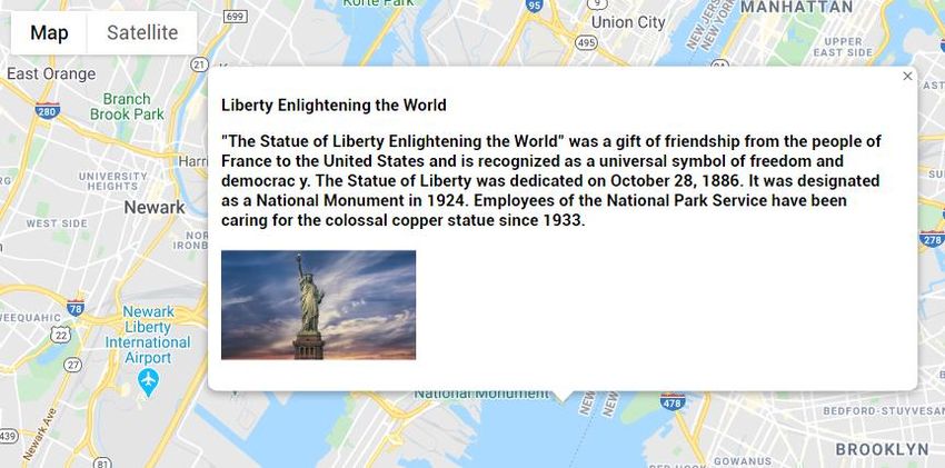
TMS SOFTWARE
                                                                                                                                      TMS FNC Maps
                                                                                                                                  DEVELOPERS GUIDE

Index
Availability ............................................................................................................................................... 4
Online references .................................................................................................................................... 4
Description .............................................................................................................................................. 4
Getting Started ........................................................................................................................................ 5
TTMSFNCMaps ........................................................................................................................................ 6
   Initialization ......................................................................................................................................... 7
   Dynamic switching............................................................................................................................... 8
   Performance ........................................................................................................................................ 8
   Markers ............................................................................................................................................... 8
   PolyElements ....................................................................................................................................... 9
   Loading GPX/GeoJSON ...................................................................................................................... 12
   Popups ............................................................................................................................................... 19
   Interaction ......................................................................................................................................... 20
   Customization.................................................................................................................................... 21
   Events ................................................................................................................................................ 25
   Common Types .................................................................................................................................. 26
TTMSFNCGoogleMaps ........................................................................................................................... 29
   Dragging Markers .............................................................................................................................. 29
   Editing Polyelements ......................................................................................................................... 30
   Loading KML Layers ........................................................................................................................... 31
   Clusters .............................................................................................................................................. 31
   Events ................................................................................................................................................ 35
   Map Style ........................................................................................................................................... 37
   Traffic & Bicycling .............................................................................................................................. 37
TTMSFNCOpenLayers ............................................................................................................................ 38
   TileServer ........................................................................................................................................... 38
TTMSFNCMapBox .................................................................................................................................. 38
   Map Style ........................................................................................................................................... 38
TTMSFNCTomTom ................................................................................................................................. 38
   Map Style ........................................................................................................................................... 38
TTMSFNCGeocoding .............................................................................................................................. 39
TTMSFNCDirections ............................................................................................................................... 42

                                                                              2
TMS SOFTWARE
                                                                                                                                    TMS FNC Maps
                                                                                                                                DEVELOPERS GUIDE

TTMSFNCLocation ................................................................................................................................. 45
TTMSFNCElevation ................................................................................................................................ 47
TMS FNC Maps Book ............................................................................................................................. 49
   Content .............................................................................................................................................. 49
   How to order ..................................................................................................................................... 50
Terms of use .......................................................................................................................................... 51
Limited warranty ................................................................................................................................... 51

                                                                            3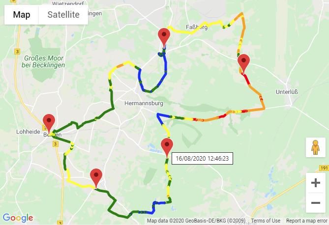
TMS SOFTWARE
                                                                                     TMS FNC Maps
                                                                                 DEVELOPERS GUIDE

Availability

Supported frameworks and platforms

   -   VCL: Win32/Win64
   -   FMX: Win32/Win64, MacOS-X, iOS, Android
   -   LCL: Win32/Win64, Mac OS-X, iOS, Android, numerous Linux variants including Raspbian
           o TTMSFNCMaps and descendant classes only run on Windows.
   -   WEB: Chrome, Edge, Firefox, …

Supported IDE’s

   -   Delphi XE7 and C++ Builder XE7 or newer releases
   -   Lazarus 1.8.0 with FPC 3.0.4 or newer releases.

Important Notice: TMS FNC Maps requires TMS FNC Core (separately available at the My Products
page)

Online references

TMS software website:
http://www.tmssoftware.com

TMS FNC Maps page:
http://www.tmssoftware.com/site/tmsfncmaps.asp

Description

TMS FNC Maps is a cross-framework, cross-platform and cross-service mapping component library. It
includes an abstract map (TTMSFNCMaps) that is capable of rendering polygons (including rectangles
and circles), polylines, markers, show HTML formatted popups and many more. It has events for
mouse interaction as well as some basic options to configure the look and feel. Optionally, the
underlying JavaScript can be modified to allow additional customization options. Also included is a
component for calculating directions between 2 coordinates or addresses (TTMSFNCDirections), the
ability to convert a coordinate to an address or vice versa (TTMSFNCGeoCoding) and retrieving your
current location (TTMSFNCLocation). Below is a list of services that are currently supported.

   -       OpenLayers (OpenStreetMaps)
   -       TomTom

   -       Microsoft Azure Maps
   -       Microsoft Bing Maps

   -       Google Maps
   -       Here Maps
   -       MapBox
   -        MapKit JS

                                                 4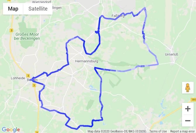
TMS SOFTWARE
                                                                                        TMS FNC Maps
                                                                                    DEVELOPERS GUIDE

Getting Started

After installing TMS FNC Core, please follow instructions on getting the TTMSFNCWebBrowser up and
running, which is the underlying component for TMS FNC Maps. More information about the browser
and its capabilities can be found at the following link:

http://www.tmssoftware.biz/Download/Manuals/TMSFNCWebBrowserDevGuide.pdf

After installing TMS FNC Maps, the first thing that needs to be done is acquiring an API key (except
for OpenLayers which is free and doesn’t require an API key). Steps to obtain an API key for
enabling the map as well as using directions, geocoding and location services can be found at the
following page:

https://www.tmssoftware.com/site/cloudkey.asp

Click on the service you are using and follow the steps to obtain an API key. The API key that is
requested can be used for all features that are available after installing TMS FNC Maps:

    -   TTMSFNCMaps (and descendants)
    -   TTMSFNCDirections
    -   TTMSFNCGeoCoding
    -   TTMSFNCLocation
    -   TTMSNFCElevation

                                                  5
TMS SOFTWARE
                                                                                       TMS FNC Maps
                                                                                   DEVELOPERS GUIDE

TTMSFNCMaps

TTMSFNCMaps is an abstract layer on top of the services that are listed under the “Description”
chapter. It serves a way to display / manipulate and retrieve information of the chosen service in an
abstract way, which means that whenever you are switching to another service, the code that was
written will be 100% compatible and will behave exactly the same as the service you were originally
been using, ofcourse under the disclaimer that the service does not change the underlying APIs.

                                                  6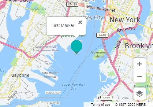
TMS SOFTWARE
                                                                                       TMS FNC Maps
                                                                                   DEVELOPERS GUIDE

Initialization

When dropping an instance of TTMSFNCMaps (after successful installation of TMS FNC Core and
TTMSFNCWebBrowser) on the form you’ll notice the designtime message indicating that Google
Maps can’t be displayed because the API key is not set. Changing the Service property will show a
different message depending on the chosen service. Please enter a value under the API key property
after selecting the component at designtime, or specify an API key at runtime that matches the
service selected under the Service property. Also note that the only selectable area (for moving,
resizing) is the area at the top. The blue area is actually a real life mapping instance, so entering
the API key at designtime will show you a live preview of the map.

procedure TForm1.FormCreate(Sender: TObject);
begin
  TMSFNCMaps1.APIKey := 'xxxxxxxxxxxxxxxx';
end;

After setting the API key, you should see the map of the service of choice.

                                                  7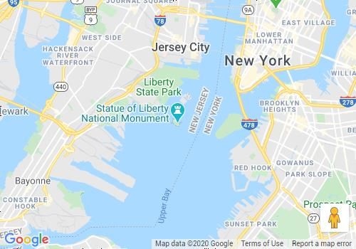
TMS SOFTWARE
                                                                                         TMS FNC Maps
                                                                                     DEVELOPERS GUIDE

Dynamic switching

A feature of TTMSFNCMaps is dynamic switching. It allows switching to another service even though
you have already added markers, polygons, polylines, ... The only settings that are not persisted are
the default location and zoom which are re-initialized to the default values. Switching or initializing
a specific service can be done with the following code:

procedure TForm1.ChangeService;
begin
  TMSFNCMaps1.Service := msBingMaps;
end;

Performance

When using the maps, adding markers, polyelements or changing existing properties of an object
that has been added to the map it is always a good practice to wrap the code with
BeginUpdate/EndUpdate. This ensures the JavaScript calls are bundled and this will lower execution
times, which automatically increases performance. Below is a sample that demonstrates how to use
BeginUpdate & EndUpdate calls for speeding up the process.

TMSFNCMaps1.BeginUpdate;
//add markers, polyelements, load GPX, GeoJSON file, …
TMSFNCMaps1.EndUpdate;

Markers

Markers identify a location on the map. Each service has its own marker icon that can (optionally)
be changed. A marker is tied to a specific location (coordinate) on the map. The default location is
the Statue of Liberty in New York (Latitude = 40.689247, Longitude = -74.044502). Below is a piece
of sample code that adds a marker, and the result shown on the map. The marker class is
TTMSFNCMapsMarker.

TMSFNCMaps1.BeginUpdate;
TMSFNCMaps1.AddMarker(DefaultCoordinate, 'First Marker!');
TMSFNCMaps1.EndUpdate;

The title of the marker can optionally be set, in this case the marker title is being shown as a hint in
Google Maps. In Here Maps for example, the marker can be clicked when a Title is set which will
show the value in a popup:

                                                   8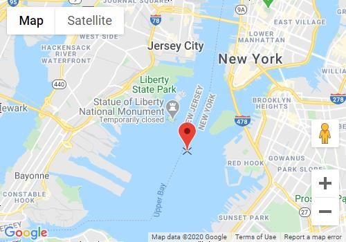
TMS SOFTWARE
                                                                                     TMS FNC Maps
                                                                                 DEVELOPERS GUIDE

When a marker has been added, changing properties will automatically update the marker, such as
changing the coordinate property to relocate the marker or specifying another title.

The marker icon can also be customized. Below is a sample that changes the default Google Maps
icon to a custom icon.

TMSFNCMaps1.BeginUpdate;
TMSFNCMaps1.AddMarker(DefaultCoordinate, 'First Marker!',
'http://myIconURL.png');
TMSFNCMaps1.EndUpdate;

Please note that AddMarker is a helper function that accesses the Marker collection. The marker
collection can also be accessed via

TMSFNCMaps1.Markers.Add;

PolyElements

PolyElements can be added in the same way as adding Markers. PolyElements include one of the
following types:

   -   TTMSFNCMapsPolyline

                                                 9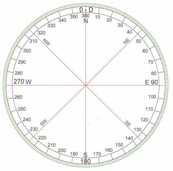
TMS SOFTWARE
                                                                                      TMS FNC Maps
                                                                                  DEVELOPERS GUIDE

   -   TTMSFNCMapsPolygon
   -   TTMSFNCMapsRectangle
   -   TTMSFNCMapsCircle

Adding a polyline and polygon is done with AddPolyline and AddPolygon respectively. Both calls
accept an array of coordinates (TTMSFNCMapsCoordinateRec). Both TTMSFNCMapsPolyline and
TTMSFNCMapsPolygon have the ability to specify a stroke color, width and opacity. The
TTMSFNCMapsPolygon has the ability to specify a fill color, width and opacity. The following sample
demonstrates how to add a polygon that represents the Bermuda triangle. The code can also be
replaced by AddPolyline, but without access to the Fill* properties.

procedure TForm1.AddMarkerToMap;
var
  arr: TTMSFNCMapsCoordinateRecArray;
  pg: TTMSFNCMapsPolygon;
begin
  SetLength(arr, 3);
  arr[0] := CreateCoordinate(25.789106, -80.226529);
  arr[1] := CreateCoordinate(18.4663188, -60.1057427);
  arr[2] := CreateCoordinate(32.294887, -64.781380);
  TMSFNCMaps1.BeginUpdate;
  pg := TMSFNCMaps1.AddPolygon(arr);
  pg.FillColor := gcOrange;
  pg.FillOpacity := 0.5;
  pg.StrokeColor := gcGreen;
  pg.StrokeWidth := 4;
  TMSFNCMaps1.EndUpdate;
end;

Adding a circle (TTMSFNCMapsCircle) is done by specifying a center coordinate and a radius (in
meter). TTMSFNCMapsCircle inherits from TTMSFNCMapsPolygon and therefore also can specify fill
and stroke properties.

Below is a sample that demonstrates how adding a circle is done with a radius of 200 km.

procedure TForm1.AddCircleToMap;
var
  c: TTMSFNCMapsCircle;
begin
  TMSFNCMaps1.BeginUpdate;

                                                10
TMS SOFTWARE
TMS FNC Maps
DEVELOPERS GUIDE
c := TMSFNCMaps1.AddCircle(DefaultCoordinate, 200000);
c.FillColor := gcOrange;
c.FillOpacity := 0.5;
c.StrokeColor := gcGreen;
c.StrokeWidth := 4;
TMSFNCMaps1.EndUpdate;
end;
Adding a rectangle (TTMSFNCMapsRectangle) is done with the AddRectangle call which accepts a
bounds (TTMSFNCMapsBoundsRec). This is defined by a NorthEast and SouthWest coordinate. Below
is a sample that demonstrates this.
procedure TForm1.AddRectangleToMap;
var
c: TTMSFNCMapsRectangle;
b: TTMSFNCMapsBoundsRec;
ne, sw: TTMSFNCMapsCoordinateRec;
begin
TMSFNCMaps1.BeginUpdate;
ne := CalculateCoordinate(DefaultCoordinate, 45, 100000);
sw := CalculateCoordinate(DefaultCoordinate, 225, 100000);
b := CreateBounds(ne.Latitude, ne.Longitude, sw.Latitude, sw.Longitude);
c := TMSFNCMaps1.AddRectangle(b);
c.FillColor := gcOrange;
c.FillOpacity := 0.5;
c.StrokeColor := gcGreen;
c.StrokeWidth := 4;
TMSFNCMaps1.EndUpdate;
end;
11TMS SOFTWARE
TMS FNC Maps
DEVELOPERS GUIDE
There is a little more explanation necessary for this piece of code that adds a rectangle. The
rectangle is 200km wide. The coordinates are calculated based on the center of the rectangle and
the bearing (0-360).
To calculate the northeast coordinate, we need to take the center coordinate and traval into the 45
degrees’ direction. The parameter “Distance” is determining how far we actually travel. The
CalculateCoordinate is a helper function in the *.TMSFNCMapsCommonTypes unit that calculates the
coordinate based on these parameters. The same applies to the SouthWest coordinate, which lies in
the 225 degrees’ direction. Finally, we are able to create a bounds rectangle with these coordinate
and plot it on the map.
Loading GPX/GeoJSON
Loading GPX/ GeoJSON is done with a single call. Specify the GPX/GeoJSON file that you wish to
load and the map will render the polyelements/lines that are retrieved inside the GPX/GeoJSON
file. The optional parameters are to AutoDisplay the data that is loaded and to automatically zoom
to the bounds of the data that has been entered. The AutoDisplay and ZoomToBounds parameters
are both true by default. Below is a sample with a GPX file.
GPX
TMSFNCMaps1.BeginUpdate;
TMSFNCMaps1.LoadGPXFromFile('run.gpx');
TMSFNCMaps1.EndUpdate;
12TMS SOFTWARE
TMS FNC Maps
DEVELOPERS GUIDE
Changing the line that has automatically been added is as simply as taking the last element from the
Polylines collection.
procedure TForm1.LoadGPX;
var
pl: TTMSFNCMapsPolyline;
begin
TMSFNCMaps1.BeginUpdate;
TMSFNCMaps1.LoadGPXFromFile('run.gpx');
pl := TMSFNCMaps1.Polylines[TMSFNCMaps1.Polylines.Count - 1];
pl.StrokeColor := gcRed;
pl.StrokeWidth := 5;
pl.StrokeOpacity := 0.5;
TMSFNCMaps1.AddMarker(pl.Coordinates[0].Coordinate.ToRec);
TMSFNCMaps1.AddMarker(pl.Coordinates[pl.Coordinates.Count -
1].Coordinate.ToRec);
TMSFNCMaps1.EndUpdate;
end;
13TMS SOFTWARE
TMS FNC Maps
DEVELOPERS GUIDE
For each Track found in the GPX file, the OnCreateGPXTrack event is triggered and for each
Coordinate found, the OnCreateGPXSegment event.
The OnCreateGPXTrack AEventData parameter contains Data.Name/Segments information as well as
the full XML node, so if extra data is available this can be parsed manually.
The OnCreateGPXSegment AEventData parameter contains
Data.Longitude/Latitude/Elevation/TimeStamp information as well as the full XML node, so if extra
data is available this can be parsed manually.
Examples:
Log standard gpx data
procedure TForm1.TMSFNCMaps1CreateGPXSegment(Sender: TObject;
AEventData: TTMSFNCMapsGPXSegmentEventData);
begin
TTMSFNCUtils.Log(AEventData.Node.GetXML);
end;
procedure TForm1.TMSFNCMaps1CreateGPXSegment(Sender: TObject;
AEventData: TTMSFNCMapsGPXSegmentEventData);
begin
TTMSFNCUtils.Log('Lat:Lon: ' + FloatToStr(AEventData.Data.Longitude) + '
: ' + FloatToStr(AEventData.Data.Longitude)
+ ' Height: ' + FloatToStr(AEventData.Data.Elevation) + ' TimeStamp: '
+ DateTimeToStr(AEventData.Data.TimeStamp));
end;
14TMS SOFTWARE
TMS FNC Maps
DEVELOPERS GUIDE
Parse extension data and display it on the map
If a given gpx file contains extra data beyond the standard available data, this can be parsed
manually through AEventData.Node.
In this example the gpx file contains a heartrate value for each coordinate. The heartrate is
extracted from the XML and a marker is added on the map along the route each time the value is
above 190.
Sample gpx data:
49
2020-04-07T13:32:17.000Z
174
Code:
procedure TForm1.TMSFNCMaps1CreateGPXSegment(Sender: TObject;
AEventData: TTMSFNCMapsGPXSegmentEventData);
var
HeartRate: Integer;
begin
HeartRate := StrToInt(NodeToString(FindNode(FindNode(AEventData.Node,
'extensions'), 'hr')));
if HeartRate > 190 then
TMSFNCMaps1.AddMarker(CreateCoordinate(AEventData.Data.Latitude,
AEventData.Data.Longitude), IntToStr(HeartRate));
end;
If a GPX file contains elevation and/or timestamp data, this data will also be available in the result
of the LoadGPXFromFile call.
15TMS SOFTWARE
TMS FNC Maps
DEVELOPERS GUIDE
Elevation data can optionally be displayed with the ADisplayElevation parameter. This is achieved
by adding multiple color coded polylines to the map. The colors to use can be provided in the
AElevationColors parameter. If a single color is provided, the polyline will be displayed darker for
lower parts and lighter for higher parts of the path. If no colors are provided, the AStrokeColor is
used. If no AStrokeColor is provided, the default color is used.
Timestamp data can optionally be displayed through markers along the polyline path with the
ADisplayTimeStamp parameter. To limit the amount of markers, the
AMinSecondsBetweenTimeStamps can be used to set the minimum time between displayed markers.
16TMS SOFTWARE
TMS FNC Maps
DEVELOPERS GUIDE
GeoJSON
GeoJSON has multiple types of data, called “Features”, such as Point, Line, Polygon, etc … Below is
a sample of a GeoJSON that is being loaded in the TTMSFNCMaps instance.
procedure TForm1.LoadGeoJSON;
var
pl: TTMSFNCMapsPolygon;
I: Integer;
begin
TMSFNCMaps1.BeginUpdate;
TMSFNCMaps1.LoadGeoJSONFromFile('data.geojson');
for I := 0 to TMSFNCMaps1.Polygons.Count - 1 do
begin
pl := TMSFNCMaps1.Polygons[I];
pl.FillColor := gcBlue;
pl.FillOpacity := 0.2;
pl.StrokeColor := gcBlue;
pl.StrokeOpacity := 0.5;
end;
TMSFNCMaps1.EndUpdate;
end;
17TMS SOFTWARE
TMS FNC Maps
DEVELOPERS GUIDE
18TMS SOFTWARE
TMS FNC Maps
DEVELOPERS GUIDE
Popups
Popups are informative messages that can be shown anywhere on the map. They are tied to a
specific coordinate and can be shown and hidden programmatically in various cases, such as clicking
on a marker, hovering over a circle, etc… A popup is capable of displaying HTML formatted text.
Below is a sample that shows how to display a popup at the default coordinate with information on
the Statue of Liberty in New York.
procedure TForm1.AddPopupToMap;
const
s = 'Liberty Enlightening the World' + LB +
'"The Statue of Liberty Enlightening the World" was a gift of friendship
from the people of ' + LB +
'France to the United States and is recognized as a universal symbol of
freedom and democrac' + LB +
'y. The Statue of Liberty was dedicated on October 28, 1886. It was
designated as a National' + LB +
' Monument in 1924. Employees of the National Park Service have been
caring for the colossal copper statue since 1933.' + LB +
'';
begin
TMSFNCMaps1.ShowPopup(DefaultCoordinate, s)
end;
Optional parameters are to offset the popup in pixels based on the default coordinate. When
showing a popup, the return value is an ID, which can be used to close it with the ClosePopup
method. The close all popups that are opened in the map, use CloseAllPopups;
19TMS SOFTWARE
TMS FNC Maps
DEVELOPERS GUIDE
Locale
The map is capable of changing the language that is displayed at some elements such as the
maptype and the street/city names. Not all maps support a full translation and not all maps support
every language. Please look up the languages that are supported depending on the chosen service.
The way the map language is translated is based on the Locale string property which is set to en-US
by default. A couple of examples of locales are:
en-US (English – United States)
en-GB (English – Great Britain)
fr-FR (French – France)
nl-NL (Dutch – Netherlands)
it-IT (Italian – Italy)
pt-BR (Portuguese – Brazil)
Applying this to the map is as simple as assigning a value to the Options.Locale property:
TMSFNCMaps1.Options.Locale := 'pt-BR';
TMSFNCMaps1.ReInitialize;
Note that a ReInitialize call is necessary to make sure the map is properly initialized.
Interaction
The map supports panning, zooming changing map type, scrolling with the mouse or keyboard and
many more. Also programmatically, you are able to go to a specific location, zoom to a specific map
bounds. Below is a list of methods that can be used to programmatically interact with the map.
TMSFNCMaps1.ZoomToBounds
The ZoomToBounds method has a couple of overloads to specify an array of coordinates, a bounds
record, or a northeast/southwest coordinate. ZoomToBounds will automatically navigate to a
specific area determined by the northeast and southwest coordinates either coming directly from
the bounds parameter or automatically calculated based on an array of coordinates.
TMSFNCMaps1.SetCenterCoordinate
20TMS SOFTWARE
TMS FNC Maps
DEVELOPERS GUIDE
The SetCenterCoordinate will navigate to a specific location on the map without changing the zoom
level.
TMSFNCMaps1.SetZoomLevel
The SetZoomLevel method can be used to set a specific zoom level at the current location on the
map.
Some maps expose a zoom control and/or maptype control that allows changing the zoom level or
switch to another map type such as a night mode or a satellite view depending on the chosen
service. The properties to enable/disable these controls are available under Options. By default,
the values are true for both properties. Below is a sample what happens when setting them to false
like the code below.
TMSFNCMaps1.Options.ShowMapTypeControl := false;
TMSFNCMaps1.Options.ShowZoomControl := false;
Customization
Each service is implemented in a specific way so the polyelements, markers, rectangles, circles and
every other aspect of the abstract TTMSFNCMaps class is working as expected even when switching
to another service. If you are missing a particular feature/event or you want to change existing
features, you have access to a series of customization events that allow you to change what
happens. Through JavaScript there are a series of constants defined to get access to objects inside
JavaScript. A complete list of variables is found in the *.TMSFNCMaps.pas unit below the version
number. Below is a list of events that allow customization.
OnCustomizeCSS
Event to customize the CSS, style information that is tied to the map, or to other objects in the map
such as popups.
OnCustomizeJavaScript
Event that is called to completely customize all JavaScript that is used to render the map and
add/update markers, polyelements and many more.
OnCustomizeMap
Event called when the map is being loaded. Additional map settings can be added here. The map
identifier that can be used is the MAPVAR constant defined in the TMSFNCMaps unit.
21TMS SOFTWARE
TMS FNC Maps
DEVELOPERS GUIDE
OnCustomizeGlobalVariables
Event called when global variables are defined, which can be accessed from each JavaScript call
that is available to the map.
OnCustomizeMarker
Event called when a marker is added or updated. This event can be used to customize markers. The
variable that is initialized when working with markers is MARKERVAR.
OnCustomizePopup
Event called when a popup is added. This event can be used to customize popups. The variable that
is initialized when working with popups is POPUPVAR.
OnCustomizeOptions
Event called when map options are changed such as the showing or hiding the zoom control or map
type control. Add any options you want to change to the map in this event.
OnCustomizePolyElement
Event called when a polyelement is added (polyline, polygon, circle, rectangle). This event can be
used to customize a polyelement. The variable that is initialized when working with popups is
POLYELEMENTVAR.
OnGetDefaultHTMLMessage
Event called when the map is being loaded but no API key is set. This message is to inform users
about that an API key is missing by default. This message can be changed through this event.
OnCustomEvent
Event called when a custom event is added and triggered from inside the map, following the rules
to call the proper communication sequence. Below is a sample that demonstrates this.
To better demonstrate how the custom events are working, a couple of examples.
Sample 1) Initializing the default map with custom maptype control (Google Maps):
procedure TForm1.TMSFNCMaps1CustomizeMap(Sender: TObject;
var ACustomizeMap: string);
var
opt: string;
begin
if TMSFNCMaps1.Service = msGoogleMaps then
begin
opt := '{' + LB +
' style: window.google.maps.MapTypeControlStyle.DROPDOWN_MENU,'
+ LB +
' mapTypeIds: [''roadmap'', ''terrain'']' + LB +
'}';
ACustomizeMap := MAPVAR + '.set(''mapTypeControlOptions'', ' + opt +
')';
end;
end;
22TMS SOFTWARE
TMS FNC Maps
DEVELOPERS GUIDE
Sample 2) Restricting map bounds to a specific area (Google Maps)
procedure TForm1.TMSFNCMaps1CustomizeMap(Sender: TObject;
var ACustomizeMap: string);
var
opt: string;
begin
if TMSFNCMaps1.Service = msGoogleMaps then
begin
ACustomizeMap :=
'var NEW_ZEALAND_BOUNDS = {' + LB +
' north: -34.36,' + LB +
' south: -47.35,' + LB +
' west: 166.28,' + LB +
' east: -175.81,' + LB +
' };' + LB + LB;
opt := '{' + LB +
' restriction:{' + LB +
' latLngBounds: NEW_ZEALAND_BOUNDS,' + LB +
' strictBounds: false' + LB +
' }' + LB +
'}';
ACustomizeMap := ACustomizeMap + 'var AUCKLAND = {lat: -37.06, lng:
174.58};' + LB;
ACustomizeMap := ACustomizeMap + MAPVAR + '.setCenter(AUCKLAND);' + LB;
ACustomizeMap := ACustomizeMap + MAPVAR + '.setZoom(7);' + LB;
ACustomizeMap := ACustomizeMap + MAPVAR + '.setOptions('+ opt +');';
end;
end;
23TMS SOFTWARE
TMS FNC Maps
DEVELOPERS GUIDE
Sample 3) adding an extra event to Bing Maps
procedure TForm1.TMSFNCMaps1CustomEvent(Sender: TObject;
AEventData: TTMSFNCMapsEventData);
begin
if AEventData.EventName = 'MapRightClick' then
begin
TTMSFNCUtils.Log('map right click detected at ' +
AEventData.Coordinate.JSON);
end;
end;
procedure TForm1.TMSFNCMaps1CustomizeMap(Sender: TObject;
var ACustomizeMap: string);
begin
if TMSFNCMaps1.Service = msBingMaps then
begin
ACustomizeMap :=
' window.Microsoft.Maps.Events.addHandler(' + MAPVAR + ',
''rightclick'', function(event){' + LB +
' ' + GETSENDEVENT + '(parseEvent(event, "MapRightClick"));' + LB +
' })';
end;
end;
24TMS SOFTWARE
TMS FNC Maps
DEVELOPERS GUIDE
Debug Output: map right click detected at
{"$type":"TTMSFNCMapsCoordinate","Latitude":40.7012209558957,"Longitude":-
74.0589215556641} Process Project17.exe (10472)
Events
OnZoomChanged;
Event called when zoom has changed. An OnZoomChanged event can occur when zooming with the
mouse, keyboard or with the map controls.
OnMapTypeChanged;
Event called when the map type has changed. An OnMapTypeChanged event can occur when the
map type is changed via the map type control.
OnMapClick;
Event called when the map is clicked.
OnMapDblClick;
Event called when the map is double clicked.
OnMapMouseUp;
Event called when the mouse is up on the map. (Occurs after an OnMouseDown event).
OnMapMouseDown;
Event called when the mouse is down on the map.
OnMapMouseMove;
Event called when the mouse is moved inside the map.
OnMapMouseEnter;
Event called when the mouse enters the map.
OnMapMouseLeave;
Event called when the mouse leaves the map.
OnMarkerClick;
Event called when a marker is clicked.
OnMarkerDblClick;
25TMS SOFTWARE
TMS FNC Maps
DEVELOPERS GUIDE
Event called when a marker is double clicked.
OnMarkerMouseUp;
Event called when the mouse is up on a marker. (Occurs after an OnMarkerMouseUp event).
OnMarkerMouseDown;
Event called when the mouse is down on a marker.
OnMarkerMouseEnter;
Event called when the mouse enters a marker.
OnMarkerMouseLeave;
Event called when the mouse leaves a marker.
OnPolyElementClick;
Event called when a polyelement (polygon, polyline, circle, rectangle) is clicked.
OnPolyElementDblClick;
Event called when a polyelement is double clicked.
OnPolyElementMouseUp;
Event called when the mouse is up on a polyelement. (Occurs after an OnPolyElementMouseUp
event).
OnPolyElementMouseDown;
Event called when the mouse is down on a polyelement.
OnPolyElementMouseEnter;
Event called when the mouse enters a polyelement.
OnPolyElementMouseLeave;
Event called when the mouse leaves a polyelement.
OnMapInitialized;
Event called when the map is initialized.
Note: Some events (like OnMarkerMouseUp, OnMarkerMouseDown, OnMarkerMouseEnter,
OnMarkerMouseLeave …) are not supported when using the Apple MapKit mapping service because
this service is mainly targeted at mobile use.
Common Types
During the development of your application with TTMSFNCMaps you’ll encounter the following
record types:
TTMSFNCMapsCoordinateRec
TTMSFNCMapsBoundsRec
They are types that allow easy conversion from the class type equivalents to pass through or
retrieve data from the map. They are defined inside the *.TMSFNCCommonTypes.pas unit and they
also come with a set of helper methods:
function CenterCoordinate: TTMSFNCMapsCoordinateRec;
method that returns a coordinate with latitude and longitude of 0.
26TMS SOFTWARE
TMS FNC Maps
DEVELOPERS GUIDE
function DefaultCoordinate: TTMSFNCMapsCoordinateRec;
method that returns a coordinate based on the default latitude and longitude (New York)
function EmptyCoordinate: TTMSFNCMapsCoordinateRec;
Method that returns an empty coordinate (which is the same as a center coordinate)
function CreateCoordinate(const ALatitude: Double; const ALongitude:
Double): TTMSFNCMapsCoordinateRec;
Method that creates a coordinate record based on a latitude and longitude value.
function CreateBounds(ACoordinates: TTMSFNCMapsCoordinateRecArray):
TTMSFNCMapsBoundsRec; overload;
Method that creates a bounds record based on an array of coordinates
function CreateBounds(ACoordinatesArray:
TTMSFNCMapsCoordinateRecArrayArray): TTMSFNCMapsBoundsRec; overload;
Method that creates a bounds record based on an array of an array of coordinates (multi-array). This
is helpful when wanting to combine arrays of coordinates from different collections such as
combining markers & polylines.
function CreateBounds(ACoordinatesArrayArray:
TTMSFNCMapsCoordinateRecArrayArrayArray): TTMSFNCMapsBoundsRec; overload;
Method that creates a bounds record based on an array of an array of an array of coordinates (multi-
array of array). This is helpful when wanting to combine arrays of coordinates from different
collections such as combining markers & polylines.
function CreateBounds(ANorthLatitude, AEastLongitude, ASouthLatitude,
AWestLongitude: Double): TTMSFNCMapsBoundsRec; overload;
Method that creates a bounds record based on an North latitude and longitude and a South latitude
and longitude
function CreateCircle(ACenter: TTMSFNCMapsCoordinateRec; ARadius: Double):
TTMSFNCMapsCoordinateRecArray;
Method that creates a circle based on a center and a radius. It returns an array of coordinates that
form a circle.
function BoundsCenter(ABounds: TTMSFNCMapsBoundsRec):
TTMSFNCMapsCoordinateRec;
Method that calculates the center of a bounds record, which is determined by a NorthEast
coordinate and a SouthWest coordinate.
function BoundsRectangle(ABounds: TTMSFNCMapsBoundsRec):
TTMSFNCMapsCoordinateRecArray;
Method that returns a rectangle based on a bounds record. It returns an array of coordinates that
form a rectangle.
function MeasureDistance(ACoordinate1: TTMSFNCMapsCoordinateRec;
ACoordinate2: TTMSFNCMapsCoordinateRec): Double;
Measures the distance between 2 coordinates.
function CalculateCoordinate(ACoordinate: TTMSFNCMapsCoordinateRec;
ABearing: Double; ADistance: Double): TTMSFNCMapsCoordinateRec;
Calculates a new coordinate based on an existing coordinate, the bearing and the distance. (Please
see chapter PolyElements for an example on using the bearing).
27TMS SOFTWARE
TMS FNC Maps
DEVELOPERS GUIDE
function CalculateBearing(ACoordinate1: TTMSFNCMapsCoordinateRec;
ACoordinate2: TTMSFNCMapsCoordinateRec): Double;
Method that calculates the bearing between 2 coordinates.
28TMS SOFTWARE
TMS FNC Maps
DEVELOPERS GUIDE
TTMSFNCGoogleMaps
TTMSFNCGoogleMaps is a descendant of TTMSFNCMaps and exposes a set of properties and methods
to add functionality specific for the Google Maps API. Each topic below goes deeper into the already
existing functionality in TTMSFNCMaps and adds more functionality on top.
Dragging Markers
After adding markers with the AddMarker function or directly through the Markers collection the
basic properties that can be set in the abstract TTMSFNCMaps class are the Visible, Title and
Coordinate properties. On top of that, the Google Maps API has the ability to add a drop animation,
make the marker draggable, clickable. For testing purposes we have added code that demonstrates
how to make a marker draggable.
procedure TForm1.AddDraggableMarker;
var
m: TTMSFNCGoogleMapsMarker;
begin
m :=
TTMSFNCGoogleMapsMarker(TMSFNCGoogleMaps1.AddMarker(DefaultCoordinate));
m.Draggable := True;
end;
When holding the mouse/finger down on the marker, a cross appears beneath and you are able to
freely drag around the marker. Releasing the mouse/finger will drop the marker to the new location
and trigger the OnMarkerDragEnd event.
In the OnMarkerDragEnd event you have 2 choices. Either leave the original coordinate store inside
the marker collection item, or synchronize. The synchronization will help in updating markers that
are already added to the map. When setting the coordinate of the marker to the new location, each
following update will not reset the marker to the original location, but to the new location. Leaving
out the code will reset the marker to the original location when another property changes.
29TMS SOFTWARE
TMS FNC Maps
DEVELOPERS GUIDE
procedure TForm1.TMSFNCGoogleMaps1MarkerDragEnd(Sender: TObject;
AEventData: TTMSFNCMapsEventData);
begin
if Assigned(AEventData.Marker) then
AEventData.Marker.Coordinate := AEventData.Coordinate;
end;
Editing Polyelements
Polyelements such as a polygon, polyline, rectangle and circle can be edited. To allow editing of a
polyelement, add the polyelement to the map as demonstrated in the previous chapter of adding
polyelements. Make sure to also specify the Editable property.
procedure TForm1.AddRectangleToMap;
var
c: TTMSFNCGoogleMapsRectangle;
b: TTMSFNCMapsBoundsRec;
ne, sw: TTMSFNCMapsCoordinateRec;
begin
TMSFNCGoogleMaps1.BeginUpdate;
ne := CalculateCoordinate(DefaultCoordinate, 45, 100000);
sw := CalculateCoordinate(DefaultCoordinate, 225, 100000);
b := CreateBounds(ne.Latitude, ne.Longitude, sw.Latitude, sw.Longitude);
c := TTMSFNCGoogleMapsRectangle(TMSFNCGoogleMaps1.AddRectangle(b));
c.Editable := True;
c.FillColor := gcOrange;
c.FillOpacity := 0.5;
c.StrokeColor := gcGreen;
c.StrokeWidth := 4;
TMSFNCGoogleMaps1.EndUpdate;
end;
When adding the rectangle to the map, you’ll notice that handles appear. These handles can be
used to change the rectangle. Whenever a change is detected the OnPolyElementEditEnd is called.
As this polyelement is a rectangle, the data is stored in the CustomData property of the
TTMSFNCMapsEventData object as it contains more than only a coordinate. The CustomData
contains an array of coordinates that can be mapped to the bounds property of the rectangle as
demonstrated in the code below. The CustomData is always JSON.
30TMS SOFTWARE
TMS FNC Maps
DEVELOPERS GUIDE
procedure TForm1.TMSFNCGoogleMaps1PolyElementEditEnd(Sender: TObject;
AEventData: TTMSFNCMapsEventData);
begin
if Assigned(AEventData.PolyElement) then
begin
if (AEventData.PolyElement is TTMSFNCGoogleMapsRectangle) then
(AEventData.PolyElement as TTMSFNCGoogleMapsRectangle).Bounds.JSON :=
AEventData.CustomData;
end;
end;
Loading KML Layers
Loading of KML layers is supported out of the box in Google Maps. Simply specify the URL of the KML
layer and Google Maps will do the rest. Below is a sample and the output of adding a KML layer.
TMSFNCGoogleMaps1.AddKMLLayer('https://developers.google.com/maps/documenta
tion/javascript/examples/kml/westcampus.kml');
An optional parameter (true by default) is to automatically zoom to the bounds of the loaded KML
layer. When executing the above code this is the result:
Clusters
Clustering is a nice feature of Google Maps that comes with a separate library
(MarkerClustererPlus). The library can be used to cluster markers together. To get started adding
clusters, first add a set of markers.
procedure TForm1.AddClusters;
var
locations: array of TTMSFNCMapsCoordinateRec;
I: Integer;
begin
locations := [
CreateCoordinate(-31.563910, 147.154312),
CreateCoordinate(-33.718234, 150.363181),
CreateCoordinate(-33.727111, 150.371124),
CreateCoordinate(-33.848588, 151.209834),
CreateCoordinate(-33.851702, 151.216968),
CreateCoordinate(-34.671264, 150.863657),
31TMS SOFTWARE
TMS FNC Maps
DEVELOPERS GUIDE
CreateCoordinate(-35.304724, 148.662905),
CreateCoordinate(-36.817685, 175.699196),
CreateCoordinate(-36.828611, 175.790222),
CreateCoordinate(-37.750000, 145.116667),
CreateCoordinate(-37.759859, 145.128708),
CreateCoordinate(-37.765015, 145.133858),
CreateCoordinate(-37.770104, 145.143299),
CreateCoordinate(-37.773700, 145.145187),
CreateCoordinate(-37.774785, 145.137978),
CreateCoordinate(-37.819616, 144.968119),
CreateCoordinate(-38.330766, 144.695692),
CreateCoordinate(-39.927193, 175.053218),
CreateCoordinate(-41.330162, 174.865694),
CreateCoordinate(-42.734358, 147.439506),
CreateCoordinate(-42.734358, 147.501315),
CreateCoordinate(-42.735258, 147.438000),
CreateCoordinate(-43.999792, 170.463352)];
TMSFNCGoogleMaps1.BeginUpdate;
for I := 0 to Length(locations) - 1 do
begin
TMSFNCGoogleMaps1.AddMarker(locations[I]);
end;
TMSFNCGoogleMaps1.EndUpdate;
end;
The second step is to add a cluster and bind the markers to a cluster. To add a cluster, use the
Clusters.Add method. Additionally, we also use a ZoomToBounds to visualize the clusters on the
map.
procedure TForm1.AddClusters;
var
locations: array of TTMSFNCMapsCoordinateRec;
I: Integer;
m: TTMSFNCGoogleMapsMarker;
begin
locations := [
CreateCoordinate(-31.563910, 147.154312),
32TMS SOFTWARE
TMS FNC Maps
DEVELOPERS GUIDE
CreateCoordinate(-33.718234, 150.363181),
CreateCoordinate(-33.727111, 150.371124),
CreateCoordinate(-33.848588, 151.209834),
CreateCoordinate(-33.851702, 151.216968),
CreateCoordinate(-34.671264, 150.863657),
CreateCoordinate(-35.304724, 148.662905),
CreateCoordinate(-36.817685, 175.699196),
CreateCoordinate(-36.828611, 175.790222),
CreateCoordinate(-37.750000, 145.116667),
CreateCoordinate(-37.759859, 145.128708),
CreateCoordinate(-37.765015, 145.133858),
CreateCoordinate(-37.770104, 145.143299),
CreateCoordinate(-37.773700, 145.145187),
CreateCoordinate(-37.774785, 145.137978),
CreateCoordinate(-37.819616, 144.968119),
CreateCoordinate(-38.330766, 144.695692),
CreateCoordinate(-39.927193, 175.053218),
CreateCoordinate(-41.330162, 174.865694),
CreateCoordinate(-42.734358, 147.439506),
CreateCoordinate(-42.734358, 147.501315),
CreateCoordinate(-42.735258, 147.438000),
CreateCoordinate(-43.999792, 170.463352)];
TMSFNCGoogleMaps1.BeginUpdate;
TMSFNCGoogleMaps1.Clusters.Add;
for I := 0 to Length(locations) - 1 do
begin
m :=
TTMSFNCGoogleMapsMarker(TMSFNCGoogleMaps1.AddMarker(locations[I]));
m.Cluster := TMSFNCGoogleMaps1.Clusters[0];
end;
TMSFNCGoogleMaps1.ZoomToBounds(TMSFNCGoogleMaps1.Markers.ToCoordinateArray)
;
TMSFNCGoogleMaps1.EndUpdate;
end;
33TMS SOFTWARE
TMS FNC Maps
DEVELOPERS GUIDE
To optionally use a custom text instead of the number of markers on a cluster icon, the Text
property can be used. Use %d to insert the marker count and the HTML character to avoid
word wrapping.
Example:
m.Clusters[0].Text := 'Markers: %d';
To optionally use custom images for clusters, the ImagePath property can be used.
Make sure the provided path is pointing to a folder that contains 5 png image files with the
following names: 1.png, 2.png, 3.png, 4.png and 5.png
Example:
TMSFNCMaps1.Clusters[0].ImagePath := 'file://' + StringReplace(ExtractFilePath(ParamStr(0)) +
'/ClusterImages/', '\', '/', [rfReplaceAll]);;
The screensho shows 2 clusters that both contain 2 markers. One is displayed with the default image
(blue) and the other one is displayed with a custom image (orange).
34TMS SOFTWARE
TMS FNC Maps
DEVELOPERS GUIDE
Events
OnClusterClick;
Event called when a cluster is clicked.
OnClusterMouseEnter;
Event called when the mouse enters a cluster.
OnClusterMouseLeave;
Event called when the mouse leaves a cluster.
StreetView
Programmatically show or hide StreetView is possible in TTMSFNCGoogleMaps through the
Options.StreetView.Enabled property. Extra properties Heading, Pitch and Zoom are also available.
Events
OnStreetViewChange
Event called each time the StreetView position changes.
The data is stored in the CustomData property of the TTMSFNCMapsEventData object as it contains
more than only a coordinate. The CustomData contains the updated values for the Heading, Pitch
and Zoom properties. The CustomData is always JSON.
35TMS SOFTWARE
TMS FNC Maps
DEVELOPERS GUIDE
procedure TForm1.mStreetViewChange(Sender: TObject;
AEventData: TTMSFNCMapsEventData);
begin
TTMSFNCUtils.Log('StreetView: ' + AEventData.CustomData);
end;
36TMS SOFTWARE
TMS FNC Maps
DEVELOPERS GUIDE
Map Style
When using TTMSFNCGoogleMaps, you are able to specify a style to change the visuals of the map.
By default, the Options.MapStyle is empty. To specify a style, you need to assign JSON to the
Options.MapStyle property. There is a predefined night style available that can be used. To create
your own style, use the Map Style Creator at https://mapstyle.withgoogle.com/
TMSFNCGoogleMaps1.Options.MapStyle := MAPSTYLENIGHT;
Traffic & Bicycling
Enabling traffic and bicycling layers is as simple as using the code below.
TMSFNCGoogleMaps1.Options.ShowTraffic := True;
TMSFNCGoogleMaps1.Options.ShowBicycling := True;
37TMS SOFTWARE
TMS FNC Maps
DEVELOPERS GUIDE
TTMSFNCOpenLayers
TTMSFNCOpenLayers is a descendant of TTMSFNCMaps and exposes extra functionality specific for
the OpenLayers API.
TileServer
When using TTMSFNCOpenLayers, you are able to specify a custom tileserver URL.
Options.TileServer
Specifies a custom tileserver URL used to display the map.
TileLayers
When using TTMSFNCOpenLayers, you are able to specify a list of tilelayers to display top of the
map layer.
TileLayers
A collection of tilelayers with an URL value and an optional Opacity value.
TTMSFNCMapBox
TTMSFNCMapBox is a descendant of TTMSFNCMaps and exposes extra functionality specific for the
MapBox API.
Map Style
When using TTMSFNCMapBox, you are able to specify a style to change the visuals of the map.
Options.MapStyle
Programmatically set a specific map style.
TTMSFNCTomTom
TTMSFNCTomTom is a descendant of TTMSFNCMaps and exposes extra functionality specific for the
TomTom Maps API.
Map Style
When using TTMSFNCTomTom, you are able to specify a style to change the visuals of the map.
Options.MapStyle
Programmatically set a specific map style.
38TMS SOFTWARE
TMS FNC Maps
DEVELOPERS GUIDE
TTMSFNCGeocoding
Usage
TTMSFNCGeocoding is a component to perform geocoding of an address or reverse geocoding of a
coordinate by using an existing REST API service.
Currently available services are:
Google
Here
Azure
Bing
TomTom
MapBox
Authorization information
API Key
Organisation
Properties
APIKey
Sets the API Key for the service
GeocodingRequests
Holds a list of geocoding/reversegeocoding results
Service
Indicates which service to use to retrieve geocoding/reversegeocoding information
Methods
procedure GetGeocoding(AAddress: string; ACallback: TTMSFNCGeocodingGetGeocodingCallBack =
nil; AID: string = ''; ADataPointer: Pointer = nil);
Retrieves a coordinate based on the provided AAddress
procedure GetReverseGeocoding(ACoordinates: TTMSFNCMapsCoordinateRec; ACallback:
TTMSFNCGeocodingGetGeocodingCallBack = nil; AID: string = ''; ADataPointer: Pointer = nil);
Retrieves an address based on the provided ACoordinates
Events
OnGetGeocoding
Triggered after calling GetGeocoding or GetReverseGeocoding. Contains the results of the
geocoding/reversegeocoding action. The ARequest.Status and ARequest.ErrorMessage values can be
used to review the status and error message (if any) returned by the selected service. In case of
multiple GetGeocoding or GetReverseGeocoding calls, the ARequest.ID value can be used to
determine which call the results are associated with.
Sample
39TMS SOFTWARE
TMS FNC Maps
DEVELOPERS GUIDE
- Sample using OnGetGeocoding event
public
TTMSFNCGeocoding1: TTMSFNCGeocoding;
procedure TTMSFNCGeocoding1GetGeocoding(Sender: TObject; const ARequest:
TTMSFNCGeocodingRequest; const ARequestResult:
TTMSFNCCloudBaseRequestResult);
procedure TForm1.FormCreate(Sender: TObject);
begin
TTMSFNCGeocoding1:= TTMSFNCGeocoding.Create(Self);
TTMSFNCGeocoding1.OnGetGeocoding := TTMSFNCGeocoding1GetGeocoding;
TTMSFNCGeocoding1.APIKey := 'abc123';
TTMSFNCGeocoding1.Service := gsGoogle;
TTMSFNCGeocoding1.GetGeocoding('New York', nil, 'origin');
TTMSFNCGeocoding1.GetGeocoding('Philadelphia', nil, 'destination');
end;
procedure TForm1.TTMSFNCGeocoding1GetGeocoding(Sender: TObject; const
ARequest: TTMSFNCGeocodingRequest;
const ARequestResult: TTMSFNCCloudBaseRequestResult);
var
I: Integer;
it: TTMSFNCGeocodingItem;
FStartAddress, FEndAddress: TTMSFNCMapsCoordinateRec;
begin
for I := 0 to ARequest.Items.Count - 1 do
begin
it := ARequest.Items[I];
if ARequest.ID = 'origin' then
begin
FStartAddress := it.Coordinate.ToRec;
TMSFNCMaps1.SetCenterCoordinate(FStartAddress);
TMSFNCMaps1.AddMarker(FStartAddress);
end;
if ARequest.ID = 'destination' then
begin
FEndAddress := it.Coordinate.ToRec;
TMSFNCMaps1.AddMarker(FEndAddress);
end;
end;
end;
- Sample using callback
public
TTMSFNCGeocoding1: TTMSFNCGeocoding;
procedure TForm1.FormCreate(Sender: TObject);
var
FStartAddress, FEndAddress: TTMSFNCMapsCoordinateRec;
begin
TTMSFNCGeocoding1 := TTMSFNCGeocoding.Create(Self);
40TMS SOFTWARE
TMS FNC Maps
DEVELOPERS GUIDE
TTMSFNCGeocoding1.APIKey := 'abc123';
TTMSFNCGeocoding1.Service := gsGoogle;
TTMSFNCGeocoding1.GetGeocoding('New York',
procedure(const ARequest: TTMSFNCGeocodingRequest; const ARequestResult:
TTMSFNCCloudBaseRequestResult)
begin
FStartAddress := ARequest.Items[0].Coordinate.ToRec;
end
);
TTMSFNCGeocoding1.GetGeocoding('Philadelphia',
procedure(const ARequest: TTMSFNCGeocodingRequest; const ARequestResult:
TTMSFNCCloudBaseRequestResult)
begin
FEndAddress := ARequest.Items[0].Coordinate.ToRec;
end
);
end;
41TMS SOFTWARE
TMS FNC Maps
DEVELOPERS GUIDE
TTMSFNCDirections
Usage
TTMSFNCDirections is a component for retrieving directions, route information and step by step
instructions for origin and destination coordinates by using an existing REST API service. The
component can be used in combination with TTMSFNCGeocoding to retrieve directions between an
origin and destination address.
Currently available services are:
Google
Here
Azure
Bing
TomTom
MapBox
Note: Google Directions is not supported on WEB due to technical limitations of the service.
Authorization information
API Key
Organisation
Properties
APIKey
Sets the API Key for the service
DirectionsRequests
Holds a list of directions results
Service
Indicates which service to use to retrieve directions
Methods
procedure GetDirections(AOrigin, ADestination: TTMSFNCMapsCoordinateRec; ACallback:
TTMSFNCDirectionsGetDirectionsCallback = nil;
AID: string = ''; ADataPointer: Pointer = nil; AAlternatives: Boolean = False; ATravelMode:
TTMSFNCDirectionsTravelMode = tmDriving; AWayPoints: TTMSFNCMapsCoordinateRecArray = nil;
AOptimizeWayPoints: Boolean = False; ALocale: string = ''; AMode: TTMSFNCMapsLocaleMode =
mlmDefault; AAvoidTolls: Booelan = False);
Retrieves directions based on the provided AOrigin and ADestination coordinates.
Optional parameters:
AAlternatives: indicates if alternative routes are included in the results
ATravelMode: indicates which travel mode to use for the directions.
Available modes:
- tmDriving
42TMS SOFTWARE
TMS FNC Maps
DEVELOPERS GUIDE
- tmWalking
- tmBicycling (only available for Azure, Google, Here, MapBox, TomTom)
- tmPublicTransport (only available for Bing, Google, Here)
- tmTruck (only available for Azure, Here, TomTom)
If a TravelMode is selected that is unavailable for the currently active service, the option will revert
to the default mode (tmDriving). The TravelMode that was used is returned in the OnGetDirections
event.
AWayPoints: optionally provide a list of waypoints
AOptimizeWayPoints: indicates if waypoints are included in the original or optimized order
ALocale: indicates the locale of the step by step instructions
AAvoidTolls: avoids using toll roads/bridges in directions (only available for Azure, Bing, Google,
Here, MapBox)
Events
OnGetDirections
Triggered after calling GetDirections. Contains the results of the directions request. The
ARequest.Status and ARequest.ErrorMessage values can be used to review the status and error
message (if any) returned by the selected service. In case of multiple GetDirections calls, the
ARequest.ID value can be used to determine which call the results are associated with.
The TravelMode that was used to determine the directions is returned in the
ARequestResult.TravelMode value.
Sample
Sample using OnGetDirections event
public
TTMSFNCDirections1: TTMSFNCDirections;
procedure TMSFNCDirections1GetDirections(Sender: TObject; const ARequest:
TTMSFNCDirectionsRequest; const ARequestResult:
TTMSFNCCloudBaseRequestResult);
procedure TForm1.FormCreate(Sender: TObject);
var
FStartAddress, FEndAddress: TTMSFNCMapsCoordinateRec;
begin
TTMSFNCDirections1:= TTMSFNCDirections.Create(Self);
TTMSFNCDirections1.OnGetDirections := TMSFNCDirections1GetDirections;
TTMSFNCDirections1.APIKey := 'abc123';
TTMSFNCDirections1.Service := dsGoogle;
TTMSFNCDirections1.GetDirections(FStartAddress, FEndAddress, nil,
'myroute', nil, False, tmDriving, nil, False, 'de-DE', mlmCountry);
end;
procedure TForm1.TMSFNCDirections1GetDirections(Sender: TObject; const
ARequest: TTMSFNCDirectionsRequest;
const ARequestResult: TTMSFNCCloudBaseRequestResult);
var
its: TTMSFNCDirectionsItems;
43TMS SOFTWARE
TMS FNC Maps
DEVELOPERS GUIDE
it: TTMSFNCDirectionsItem;
I: Integer;
begin
TMSFNCMaps1.BeginUpdate;
its := ARequest.Items;
for I := 0 to its.Count - 1 do
begin
it := its[I];
if ARequest.ID = 'myroute' then
begin
if it.Coordinates.Count > 0 then
TMSFNCMaps1.AddPolyline(it.Coordinates.ToArray).StrokeColor :=
gcRed;
end;
end;
TMSFNCMaps1.EndUpdate;
end;
44You can also read