Development Scheme Oonoonba Urban Development Area
←
→
Page content transcription
If your browser does not render page correctly, please read the page content below
Oonoonba
Urban Development Area
Development Scheme

         Effective 15 April 2011
         Last amended 7 August 2021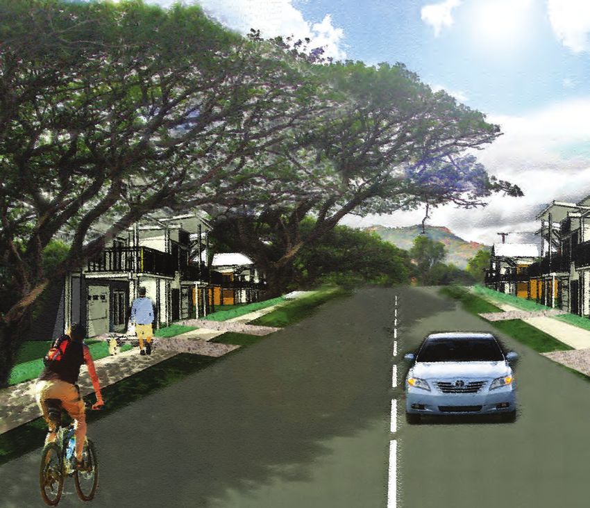
Oonoonba Urban Development
Area Development Scheme
Declared 23 April 2010
Effective 15 April 2011
Amendment 1 Effective 7 August 2021
Contents

Oonoonba Urban Development Area Development Scheme

Introduction............................ 1   Introduction................................. 1                             3.4 Zone provisions..............................................10
                                                                                                                             3.4.1 Residential Zone intent....................... 10
                                             1.1   The Urban Land Development Authority.......... 1
Strategic Context..................... 2     1.2   Urban Development Area................................ 1                   3.4.2 Mixed Use Zone intent........................ 10
                                             1.3   Purpose of the development scheme.............. 1                          3.4.3 Open Space Zone intent...................... 10
Land Use Plan......................... 5     1.4   Elements of the development scheme............. 1                          3.4.4 Environmental Zone intent.................. 10
Infrastructure Plan............... 13                                                                                         3.4.5 Special Purpose Zone intent............... 10
                                             Strategic Context.......................... 2
Implementation Strategy...... 14             2.1 Location......................................................... 2     Infrastructure Plan.................... 13
                                             2.2 Vision............................................................. 2
Schedules.............................. 16   2.3 Structure Plan................................................. 3       Implementation Strategy........... 15
                                             Land Use Plan.............................. 5                               Schedules................................... 17
                                             3.1 Purpose of the land use plan.......................... 5                Schedule 1: Exempt development........................17
                                             3.2 Development assessment procedures............ 5                         Schedule 2: Definitions........................................19
                                                 3.2.1 Land use plan ..................................... 5             Schedule 3: Amendments................................... 23
                                                   3.2.2 UDA vision........................................... 5
                                                   3.2.3 UDA development requirements.......... 5
                                                   3.2.4 Levels of assessment........................... 6
                                                   3.2.5 Development consistent with the land
                                                         use plan............................................... 6
                                                   3.2.6 Consideration in principle.................... 6
                                                   3.2.7 Land not included in a zone................. 6
                                                   3.2.8 Notification requirements.................... 6
                                                   3.2.9 Relationship with local government
                                                         planning scheme and SPA................... 6
                                             3.3 UDA-wide criteria........................................... 7
                                                 3.3.1 Housing and community...................... 7
                                                   3.3.2 Neighbourhood, block and lot design.. 7
                                                   3.3.3 Street design and parking.................... 8
                                                   3.3.4 Environment and sustainability........... 8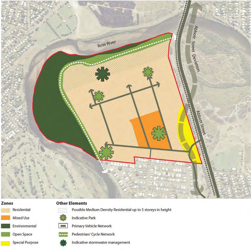
Introduction 1.0
1.1 Interpreting the to ecological sustainability and best From the date of approval, the development
practice urban design scheme replaces the Interim Land Use
development scheme (v) the provision of an ongoing availability Plan for the UDA which commenced upon
The Oonoonba Urban Development Area of affordable housing options for low to declaration.
Development Scheme took effect on 15 April moderate income households.
2011.
The ULDA works with local governments, 1.5 Elements of the
On 1 February 2013 the Urban Land community, local landowners and
Development Authority Act 2007 (ULDA Act) the development industry to deliver
development scheme
was repealed. Chapter 6 of the Economic commercially viable developments that The Oonoonba UDA Development Scheme
Development Act 2012 (ED Act) provides for include diverse, affordable, sustainable consists of:
the transition of an Urban Development Area housing and use best-practice urban
È a land use plan
(UDA) to a Priority Development Area (PDA). design principles.
For the interpretation of terminology used in È an infrastructure plan
this development scheme, chapter 6 of the È an implementation strategy.
ED Act includes transitional provisions which 1.3 Urban Development The land use plan regulates development
should be referred to. Area and states the preferred form of development
in the UDA.
The Oonoonba Urban Development Area
1.2 The Urban Land (UDA) was declared by regulation on 23 April The infrastructure plan details the
2010. infrastructure necessary to support the land
Development use plan for the UDA.
Authority The implementation strategy describes other
The Urban Land Development Authority
1.4 Purpose of the strategies and mechanisms that the ULDA
(ULDA) is a statutory authority under the development scheme will use to complement the land use plan and
Urban Land Development Authority Act infrastructure plan to achieve the outcomes
The Oonoonba UDA Development Scheme
2007 (the Act) and a key element of the for the UDA.
(the scheme) has been prepared in
Queensland Housing Affordability Strategy.
accordance with the Act and is applicable
The role of the ULDA is to facilitate: to all development on land within the
boundaries of the UDA. It is a statutory
(i) the availability of land for urban purposes
instrument and has the force of law.
(ii) the provision of a range of housing
options to address diverse community The purpose of the development scheme
needs is to establish the overall intentions for
development of the UDA as well as identify
(iii) the provision of infrastructure for
a broad range of requirements applicable to
urban purposes
proposed development.
(iv) planning principles that give effect
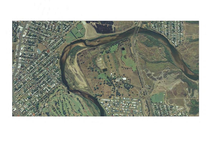
Oonoonba Urban Development Area Development Scheme 12.0 Strategic Context
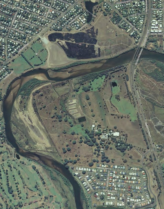
2.1 Location 2.2 Vision Map 1: Oonoonba UDA boundary
The Oonoonba UDA covers 83 hectares The Oonoonba UDA will become a model
1. Bicentennial Park
of land in the suburb of Oonoonba, about residential neighbourhood distinguished by: 2. Ross River
3.5kms south of the Townsville City Centre. 3. Abbott Street
È a range of housing options suited to the 4. Townsville Golf Course
The Oonoonba UDA is a promontory bounded local environment and the particular 5. Fairfield Waters
6. Oonoonba Park
by the Ross River to the west and north, a needs of the Townsville community
Urban Development Area boundary
rail corridor and Abbott Street road corridor È a neighbourhood centre that provides a
to the east, and the suburb of Idalia to the community focus and features innovative
south. The site was formerly used as a and varied forms of residential and non-
Queensland Government cattle and research residential uses 1
station.
È residential areas offering a range
The Oonoonba UDA is in a prime location for of building heights and densities,
low-to-medium density residential and mixed complementary non-residential uses and 2
use development, offering: uses that combine living and working
È convenient connections to existing È strong links to and promotion of access
and planned major transport networks to the Ross River for both residents of the
servicing Townsville from the south UDA and Townsville generally
È substantial existing service infrastructure È views of Castle Hill, a prominent
Townsville landmark
È significant shade and other trees,
3
suitable for retention in public parks and È pedestrian and cycle networks that
open space connect important destinations within
the UDA, and nearby suburbs and the
È the opportunity to open up public access
Townsville City Centre beyond the UDA
to the Ross River for new residents and
residents of neighbouring areas È retention of significant existing trees as
important features in public places
È the opportunity to provide new local
services to adjacent and nearby È acknowledging the site's indigenous
residential areas heritage and history of military use.
6
È suitable land for a wide range of housing
types, styles and prices
4
È convenient cycling to the City Centre 5
È views of Castle Hill, a prominent
Townsville landmark.
2 Oonoonba Urban Development Area Development SchemeStrategic Context 2.0
The UDA will: Manage environmental values by: È ensuring street patterns, the location Be a safe place to live by:
of open spaces and planting, and the
House the future by: È retaining significant trees in public areas È locating housing to overlook open space
orientation and design of buildings and
È enhancing the marine habitat, preserving and paths to improve surveillance and
È creating residential and mixed use areas openings, capture and channel cooling
the river sandbank personal safety
with a range of densities, types, designs, breezes, particularly from the north-east
prices, home ownership and rental È applying best practice water sensitive È ensuring land is rehabilitated and
È identifying opportunities to recognise the
options to deliver a range of housing urban design removed from the Environmental
site's indigenous heritage and history of
choices for low to moderate income Management Register or Contaminated
È striking a balance between natural military use
families, key workers, singles, couples, Land Register prior to works or sensitive
and built elements considering land È drawing on the site's landform and
first home buyers and retirees uses commencing.
form, climate and ecology to maximise existing vegetation to create a distinctive
È providing a variety of housing types environmental conservation, amenity neighbourhood which reinforces the Promote planning and design excellence by:
that cater for the changing needs of the and contribute to the desired landscape existing landscape character and È becoming a modern, resilient and
Townsville community. character. enhances local amenity adaptable urban area that promotes
Be a connected place by: Be a liveable community by: È exploring new forms of tropical connectivity, safety and accessibility
architecture appropriate for the whilst recognising what is important to
È locating the neighbourhood centre on È providing employment opportunities in
Townsville context the Townsville community
higher ground at the entry to the UDA the neighbourhood centre, and also in
to establish its prominence and create a home based businesses in residential È promoting community health and È embracing a Queensland building style
community focus areas, such as micro-small businesses wellbeing through a neighbourhood that is in keeping with a tropical context.
and service industries design that supports a healthy and active
È framing the neighbourhood centre with
mid-rise medium density housing and È providing access to the Ross River by
lifestyle 2.3 Structure Plan
small-scale mixed uses to maximize creating shaded and cool places to rest È ensuring development is sensitive to the The Structure and Zoning Plan (refer to Map
activity in the centre and accessibility to and relax, and paths to walk and ride environment by using, where possible, 2) for the Oonoonba UDA illustrates:
services along the river banks efficient sources of energy and waste
È preservation of the Ross River bank along
disposal
È facilitating a street pattern and pathways, È establishing a civic-style neighbourhood the northern boundary and the sand
that link parks to the river and support park to the east of the neighbourhood È providing necessary community, social bank along the western and northern
local trips to nearby schools and shops centre, and another park to the west, and cultural infrastructure boundaries of the UDA
È opening vistas to Castle Hill, through the to provide places for the community to È recognising opportunities to use existing È a riverside park on the south western
street pattern and other elements, which gather, relax and play under the shade of buildings on the site. boundary where the high ground meets
visually connect the UDA to the city and many of the site's existing rain, fig and the river, visible and accessible from the
Be a good neighbour by:
surrounding suburbs other feature trees major boulevard off Lakeside Drive
È addressing interfaces between new uses
È using street treatments to reinforce a È an esplanade along the western and
in the UDA and existing residential areas.
clear hierarchy of pedestrian and cycle northern edges of the high ground from
routes. Fairfield Waters through to Abbott Street
that is entirely accessible to the public
and suitable for both walking and cycling
Oonoonba Urban Development Area Development Scheme 32.0 Strategic Context
È evenly distributed, well-connected and Map 2: Oonoonba UDA structure and zoning plan
accessible neighbourhood and pocket
parks, creating a useable public open
space network within easy walking and
cycling distance of every residence
Abbott
È a simple street grid structure, suitable
for public transport, with a central spine
River
Street Dev
looking towards Castle Hill Ross
È a neighbourhood centre including a
significant neighbourhood park framed
iatio
by community, commercial, retail,
n
medium-density residential and small
scale mixed use
È retention of existing rain, fig and other
feature trees, where possible, in parks,
streets and other open space areas
È indicative location for flood and
Abb
stormwater management
ot t Stre
È the allocation of land for the possible
et
future Abbott Street deviation,
incorporating an overpass over the
railway line.
Zones Other Elements
Residential Possible Medium Density Residential up to 5 storeys in height
Mixed Use Indicative Park
Environmental Primary Vehicle Network
Open Space Pedestrian/ Cycle Network
Special Purpose Indicative stormwater management
4 Oonoonba Urban Development Area Development SchemeLand Use Plan: Context Land Use Plan: Context 3.0
3.1 Purpose of the land 3.2.2 UDA vision Figure 1: Components of the land use plan and their relationship
use plan The vision:
(i) seeks to achieve for the UDA the Vision
The purpose of the land use plan is to
regulate development and state the purposes of the Act, and Vision and structure plan
preferred form of development within the (ii) provides the basis for the UDA
Urban Development Area (UDA). development requirements.
Figure 1 details the components of the land The UDA vision is spatially represented in UDA development requirements
use plan and explains their relationship to Map 2.
UDA-wide criteria
each other.
3.2.3 UDA development requirements È Housing and community
È Neighbourhood, lot and block design
3.2 Development The UDA development requirements are
expressed through: È Street design and parking
assessment È Environment and sustainability
(i) development criteria for the whole UDA
procedures (UDA-wide criteria)
3.2.1 Land use plan (ii) Oonoonba UDA Structure and Zoning Zone provisions
Plan
The land use plan: È Zone intents
(iii) development provisions for a specific
(i) identifies the vision for the Oonoonba zone (Zone intent) È Structure and Zoning Plan
UDA, and È Level of assessment tables
(iv) tables specifying the level of assessment
(ii) states the requirements for carrying out for development for each zone (level of
development to achieve the vision for the assessment table).
UDA.
Oonoonba Urban Development Area Development Scheme 53.0 Land Use Plan: Context
3.2.4 Levels of assessment Identification of development as UDA (iii) it cannot accept the proposal until a 3.2.8 Notification requirements
assessable development does not mean detailed assessment is made through a
The levels of assessment for the carrying out A UDA development application will require
that a UDA development approval (with or UDA development application, or
of development in the UDA are in the relevant public notification if the development
without conditions) will be granted. (iv) it has no established view on the
level of assessment table for the zone which application is for a use, or of a size or nature
states in: UDA assessable development requires a proposal and no indication of support or which, in the opinion of the ULDA, warrants
UDA development application to be lodged opposition. public notification.
(i) column 1, UDA exempt development
with the ULDA for assessment and decision. The ULDA when considering a UDA
(ii) column 2, UDA self assessable Residential development in the Residential
Approval is required for UDA assessable development application:
development Zone that complies with the zone intent will
development to be undertaken.
(i) is not bound by any decision not require public notification.
(iii) column 3, UDA assessable development.
In this section 'grounds' means matters of made regarding an application for
public interest which include the matters 3.2.9 Relationship with local
3.2.5 Development consistent with the consideration in principle
specified as the main purposes of the Act as government planning scheme
land use plan (ii) may give such weight as it considers and SPA
well as:
appropriate to the decision in respect
UDA self-assessable development which (i) superior design outcomes of the application for consideration in This development scheme replaces the
complies with applicable development principle. Oonoonba Interim Land Use Plan (ILUP).
(ii) overwhelming community need.
requirements is consistent with the land use
'Grounds' does not include the personal 3.2.7 Land not included in a zone Unless this development scheme specifically
plan.
circumstances of an applicant, owner or applies a provision of a planning instrument
UDA assessable development is consistent This section applies to land which is not or a plan, policy or code made under the
interested third party.
with the land use plan if: shown in the land use plan as being included Sustainable Planning Act 2009 (SPA) or
in a zone (unallocated land). another Act, the development scheme
(i) the development complies with the UDA 3.2.6 Consideration in principle
development requirements, or Where the unallocated land is adjoined prevails to the extent of an inconsistency
The ULDA may accept, for consideration in with those instruments.
(ii) the development does not comply with by land in a zone, the unallocated land is
principle, a proposed UDA development
the UDA development requirements but: deemed to be included in that zone.
application (application for consideration in
a. the development does not conflict principle). Where the unallocated land is adjoined
with the vision for the UDA and by land included in different zones, the
The ULDA will consider the application for
b. there are sufficient grounds to unallocated land is deemed to be included
consideration in principle and may decide
approve the development despite in those zones with the centreline of the
the following:
the non compliance with the UDA unallocated land being the boundary
(i) it supports the application, with or between the zones.
development requirements.
without qualifications that may amend
Otherwise, the UDA assessable development the application
is inconsistent with the land use plan and
(ii) it opposes the application
must be refused.
6 Oonoonba Urban Development Area Development SchemeLand Use Plan: UDA wide criteria 3.0
3.3 UDA-wide criteria 3.3.1 Housing and community È use infrastructure efficiently. for shared use of public facilities by
adjoining communities
The following criteria apply to all UDA The UDA delivers housing affordability and Neighbourhood planning and design:
choice. È provides parks that cater for a variety of
assessable and self-assessable development È gives the neighbourhood a strong and functions and experiences and that are
in the Oonoonba UDA. To the extent that Residential neighbourhoods: positive identity by responding to site safe and accessible for users
the criteria are relevant, they are to be characteristics, setting, landmarks
taken into account in the preparation of È deliver a minimum of 50 percent of all È locates services and utilities to maximise
and views, and through clearly legible
UDA development applications and the dwellings across the UDA available for efficiency and ease of maintenance.
street networks, open space and use of
assessment of those applications by the purchase at or below the median house
streetscape elements The public realm of civic spaces, parks,
ULDA. price for Townsville
È delivers appropriate scale of plazas, footpaths, urban streets and other
È deliver a minimum of 40 percent of all shared community spaces, notably in and
The UDA-wide criteria should be read with development
dwellings available to purchase or rent to around the neighbourhood centre, are clearly
the relevant statement of zone intent. È incorporates principles for crime
low to moderate income households for delineated from, but integrated with, the
The infrastructure plan and implementation Townsville prevention through environmental design
private realm and comprise:
strategy may include further information, (CPTED)
È deliver 10 percent of all dwellings as
which should be taken into account in È identifies appropriate areas for multiple È a sense of place reflecting the character
accessible housing to meet the changing
the design and feasibility of development residential and mixed uses of the location
needs of people and households over
proposals. time È ensures adequate visual and noise È material and plant selection appropriate
amenity to the location and relevant to the sense
The Oonoonba UDA-wide criteria cover the È contribute to housing choice by providing
of place
following topics: a range of housing types. È maximises opportunities for views and
vistas È shade trees along streets and within
È housing and community public and private spaces
3.3.2 Neighbourhood, block and lot È achieves a balanced mix of lot sizes to
È neighbourhood, lot and block design È an appropriate climate-based orientation
design provide housing choice and streetscape
È street design and parking variety and design, ensuring shade is provided,
The UDA delivers development designed to: breezes are captured and optimal use is
È environment and sustainability. È responds to natural features, including
È maximise connectivity made of natural light
For more detail on how to comply with the topography and natural drainage features
È be responsive to the local climate and È setbacks for the movement of
requirements listed below refer to guidelines È promotes healthy and active lifestyles
site features pedestrians and standing areas for public
issued by the ULDA1. by prioritising walking and cycling within
È include walkable streets and transport stops
the UDA and connecting to facilities and
neighbourhoods services outside the UDA È at ground level, buildings designed to
È provide personal safety and security integrate shopping, dining, and other
1 Including ULDA guideline no. 01 Residential 30, È incorporates orientation for solar access
outdoor activities and continuous
Affordable Housing Strategy and the Accessible È enhance character and amenity and natural ventilation
Housing and Environment and Sustainable awnings to provide protection from the
Development Guidelines. È integrates development with the rain and sun and integrated with street
surrounding environment and provides plantings
Oonoonba Urban Development Area Development Scheme 73.0 Land Use Plan: UDA wide criteria
È opportunities for informal and formal and minimising negative impacts of È adequate provision for the number and waters and appropriately manages
play, meeting and gathering through traffic nature of vehicles expected. stormwater
È opportunities to highlight local history, È provides a safe and pleasant Car parking is provided for business, retail È minimises adverse impacts on natural
landmarks and culture through public environment through lighting, pavement and community and service uses as follows: landforms and visual amenity of the site
information and artwork treatment and materials, clear sight lines È retains significant vegetation where
and landscaping È 1 space per 30m2 of gross floor area
È where possible, balconies to enable possible within parks, along streets and
surveillance and overlooking of public È provides movement networks for È up to 50 percent of car parking spaces within development sites
spaces and places. vehicles, pedestrians and bicycles may be provided off site, where in close
È ensures that all land and groundwater
that have a clear structure, provide a proximity to the site and in accordance
Adequate lots for non-residential or mixed will be fit for its intended use in
high level of internal accessibility and with a parking management plan.
use development are provided in appropriate accordance with accepted standards and
good external connections with the Car parking is provided for Multiple practices
locations to facilitate business and
surrounding area, and maximise public residential as follows:
employment generation, taking into account: È maintains or enhances marine habitat
transport effectiveness
È at a rate of 1 space per dwelling unit within the bed and banks of the Ross
È the need for businesses and home based È provides for pedestrian and cycle
È 1 space for every 4 dwellings for visitor River including the western sandbank
businesses to be located in and around connections within the site which
the neighbourhood centre parking È incorporates leading energy efficiency2
connect to existing facilities and support
È 1 space for car washing. and water efficiency practices, maximises
È opportunities for businesses and home movement to key city-wide, district
recycling opportunities and reduces
based businesses with vehicular access and local destinations such as shops, Variations to car parking provision may be waste generation
via rear lanes schools, parks and community facilities appropriate in close proximity to public
È promotes the adoption of decentralised
È the capacity on mixed use lots to È supports public transport routes and transport stops.
energy generation systems and natural
effectively change between mixed uses facilities and provides safe, legible and
ventilation to reduce energy use
and housing. attractive connections from residential 3.3.4 Environment and sustainability
areas to public transport nodes or stops È incorporates landscaping that contributes
The UDA delivers: to flora and fauna habitat and fauna
3.3.3 Street design and parking È does not unreasonably constrain
È minimal emissions to land, water and movement, with street trees selected
The UDA delivers: future provision of public transport
atmosphere from species native and/or endemic to
infrastructure and does not adversely
È efficient and safe street networks for all the Oonoonba UDA
impact on the function or operation È efficient use of land and resources
users of existing or future public transport È demonstrates consistency with current
È protection of amenity, ecological values
È adequate car parking corridors. best practice for the identification and
and natural systems including the marine
management of acid sulfate soils
È access to public transport networks. Planning and design of vehicle access and habitat and sandbank of the Ross River.
Street network planning and design: parking ensures: The design, siting and layout of
2 For Class 1 and Class 2 buildings (as defined in the
È safety and convenience for residents, development: Building Code of Australia 2009) the Queensland
È connects to existing networks while Development Code MP 4.1 Sustainable buildings
ensuring acceptable levels of amenity visitors and service providers È minimises adverse impact on the outlines minimum requirements in terms of
environmental values of the receiving energy efficiency and efficient fixtures for water
conservation.
8 Oonoonba Urban Development Area Development SchemeLand Use Plan: Zones and Precincts 3.0
È appropriately manages mosquito Map 2: Oonoonba UDA structure and zoning plan
breeding areas
È development will achieve an appropriate
level of flood immunity3.
During construction, adverse impacts on
amenity are minimised.
3 The Defined Flood Event for the Oonoonba UDA
is the 100 year ARI. This flood level is mapped in
the Oonoonba Flood and Stormwater Management
Study.
Oonoonba Urban Development Area Development Scheme 93.0 Land Use Plan: Zones and Precincts
3.4 Zone provisions riverside park in the south west, a small in the southern part of the neighbourhood Buildings and structures may include picnic
neighbourhood park in the north west, centre, close to the main entrance road. amenities, children's playgrounds, facilities
The Oonoonba UDA is divided into five zones. a small neighbourhood park around the for spectators, club buildings and associated
The location and boundaries of the zones are Community and service uses may be
historical bomb crater in the north east, and off-street parking.
shown on Map 2: Oonoonba UDA structure developed within existing buildings in the
a larger neighbourhood park near the Mixed
and zoning plan. northern part of the neighbourhood centre. Existing trees and natural features will be
Use Zone. Existing trees and other natural
retained where possible.
vegetation will be retained where possible Small lot mixed uses are appropriate
3.4.1 Residential Zone intent within all parks in the zone. throughout the zone.
3.4.4 Environmental Zone intent
The Residential Zone caters for a range of The Residential Zone includes land that The neighbourhood centre is also intended
residential types including Houses, Multiple The purpose of the Environmental Zone is to
will be required for flood and stormwater to include a neighbourhood park with
Residential, Other Residential and Home maintain or enhance the natural functions
management. pedestrian and cyclist connections through
Based Businesses. and habitats of the Ross River along the
to other parks and open spaces in the vicinity
boundary of the UDA.
Non-residential land uses including Business, 3.4.2 Mixed Use Zone intent of the neighbourhood centre. Ideally this
Retail and Community and Service uses, may park will be framed by mid-rise medium It is also intended that the zone provide for
The Mixed Use Zone caters for a range
be suitable in the Residential Zone. However, density housing, small-scale mixed uses and the possibility of constructing structures
of Business, Retail, Residential, Sport
these uses are only appropriate if residential home-based businesses. such as boardwalks and pathways where
Recreation and Entertainment, Industrial and
character and amenity are maintained located and designed to avoid adverse
Service and Community uses. Existing buildings and infrastructure are
and the use caters only for the needs of impacts on the marine environment or the
intended to be utilised to their maximum
the immediate community and does not Building height and density for the Mixed need for revetment or stabilisation works.
potential and existing feature trees will be
undermine the viability of uses in the Mixed Use Zone are generally 5 storeys and 150
retained where possible throughout the
Use Zone or nearby retail centres. dwellings per hectare. 3.4.5 Special Purpose Zone intent
zone.
Building height and density for residential The Mixed Use Zone is intended to The Special Purpose Zone is primarily
A public transport stop should also
uses are generally up to three storeys and incorporate a neighbourhood centre, intended to be utilised for land required to
be provided in association with the
30 dwellings per hectare; however on lots including a significant neighbourhood park construct the Abbott Street deviation.
neighbourhood centre.
immediately adjoining Fairfield Waters the framed by Multiple Residential, Business,
A central neighbourhood park will be However, if it should be determined the
height of buildings is limited to 2 storeys. In Retail and Community and Service uses.
provided within the zone. Existing trees land is not required for transport purposes
the northern part of the residential zone as The neighbourhood centre is intended to it is intended that it be used for residential
and other natural vegetation will be retained
shown on Map 2, building heights of up to provide a focal point for the Oonoonba purposes consistent with the Residential
where possible within the park.
five storeys and densities up to 150 dwellings residential area as well as the neighbouring Zone.
per hectare are appropriate. residential community of Fairfield Waters.
3.4.3 Open Space Zone intent
A variety of parks will be provided within Residential shop-top housing is encouraged
above Business and Retail uses generally The Open Space Zone caters for the Ross
the zone, including: a neighbourhood
River esplanade and includes a range of
publicly accessible outdoor recreation spaces
and uses such as parks, pedestrian pathways
and cycleways.
10 Oonoonba Urban Development Area Development SchemeLand Use Plan: Zones and Precincts 3.0
Level of assessment table
Column 1 Column 2 Column 3 – UDA assessable development
Exempt development UDA self assessable development
In the Residential Zone
Development specified in Schedule 1 Making a material change of use for a House on a lot greater than All development, including development not defined in Schedule 2,
except if the land is on the Environmental 450m2 except if the land is on the Environmental Management other than development mentioned in Column 1 or Column 2.
Management Register or Contaminated Land Register or Contaminated Land Register.
Register.
If consistent with an approved Plan of Development and the land is
not on the Environmental Management Register or Contaminated Land
Register:
1. Making a material change of use for:
a. House
b. Multiple residential.
2. Carrying out operational work, other than that specified in
Schedule 1, for:
a. Filling or excavation
b. Reconfiguring a lot.
Environmentally relevant activities for which a code of environmental
compliance has been made under the Environmental Protection
Regulation 2008 except if the land is on the Environmental
Management Register or Contaminated Land Register.
Oonoonba Urban Development Area Development Scheme 113.0 Land Use Plan: Zones and Precincts
Column 1 Column 2 Column 3 – UDA assessable development
Exempt development UDA self assessable development
In the Mixed Use Zone
Development specified in Schedule 1 except if Making a material change of use for a House on a lot greater then 450m2 except if the All development, including development not defined
the land is on the Environmental Management land is on the Environmental Management Register or Contaminated Land Register. in Schedule 2, other than development mentioned in
Register or Contaminated Land Register. Column 1 or Column 2.
If consistent with an approved Plan of Development and the land is not on the
Environmental Management Register or Contaminated Land Register:
1. Making a material change of use for:
a. House
b. Multiple residential
2. Carrying out operational work, other than that specified in Schedule 1, for:
a. Filling or excavation
b. Reconfiguring a lot.
Environmentally relevant activities for which a code of environmental compliance has
been made under the Environmental Protection Regulation 2008 except if the land is
on the Environmental Management Register or Contaminated Land Register.
In the Open Space Zone
Development specified in Schedule 1 except if Nil All development, including development not defined
the land is on the Environmental Management in Schedule 2, other than development mentioned in
Register or Contaminated Land Register. Column 1 or Column 2.
In the Special Purpose Zone
Development specified in Schedule 1 except if Environmentally relevant activities for which a code of environmental compliance has All other development, including development not
the land is on the Environmental Management been made under the Environmental Protection Regulation 2008. defined in Schedule 2, other than development
Register or Contaminated Land Register. mentioned in Column 1 or Column 2.
In the Environmental Zone
Nil Nil All development consistent with the maintenance or
enhancement of the marine habitat within the bed
and banks of the Ross River and the construction of
pathways and boardwalks.
12 Oonoonba Urban Development Area Development SchemeInfrastructure Plan 4.0
4.1 Purpose which an offset against infrastructure 4.4 Infrastructure 4.4.2 Non-trunk infrastructure
charges shall be available, and
The purpose of this infrastructure plan is to Categories Non-trunk infrastructure is the lower order
ensure that the vision is achieved through: iii. matters relevant to calculating an offset infrastructure which generally services
or refund for the provision of trunk The infrastructure planned to be delivered a single development site, is internal
È integrating infrastructure planning with infrastructure. within the UDA will fall into one of the to a development site, or connects the
land use planning identified in this following categories: development site to trunk infrastructure.
development scheme The DCOP is supported by an Infrastructure
Planning Background Report (IPBR). The È Trunk infrastructure Non-trunk infrastructure will be provided
È identifying the infrastructure
IBPR documents information relevant to È Non-trunk infrastructure, or by the applicant, in accordance with the
requirements which may be delivered by
infrastructure planning and development relevant responsible entity’s requirements
the relevant infrastructure provider such È other infrastructure.
charging for the UDA, such as development and as specified in a condition of a
as local government, state government,
assumptions and identified desired Table 1 includes infrastructure which is UDA development approval. Non-trunk
or applicants
standards of service. trunk infrastructure, non-trunk infrastructure infrastructure will not be eligible for an
È providing a basis for imposing and other infrastructure. To determine if infrastructure charges offset.
conditions on development approvals, 4.3 Infrastructure infrastructure is eligible for an offset, refer
and
Network to the Development Charges and Offset Plan 4.4.3 Other infrastructure
È responding to the increased demand on (DCOP).
The following infrastructure networks Other infrastructure includes infrastructure
the relevant infrastructure networks
require additional infrastructure provision or which is not part of Townsville City Council’s
4.4.1 Trunk infrastructure
4.2 Relationship to upgrades to support growth in the UDA: infrastructure networks. Other infrastructure
Trunk Infrastructure is generally the high may include necessary development
Development È transport (roads, intersections,
order shared infrastructure that is planned infrastructure or provision for upgrades to
pedestrian and cycle paths)
Charges Offset Plan to service the wider catchments internal or the electricity, gas or telecommunications
È parks and open space external to the UDA, rather than individual networks. Other infrastructure may be
The infrastructure plan section of this delivered by state government, other
È water supply development sites. The development
development scheme is to be applied infrastructure providers or by developers
È sewerage charges and offset plan (DCOP) identifies
in conjunction with the Oonoonba UDA who may be required to deliver or preserve
infrastructure eligible for an offset. Tunk
Development Charges and Offsets È community facilities. the ability to provide this infrastructure by a
infrastructure may be delivered by the
Plan (DCOP). The DCOP incorporates Table 1 identifies key infrastructure that condition of a UDA development approval,
relevant infrastructure provider such as
infrastructure planning, charges and offsets will be provided to enable the vision to be or to service their development.
local government, state government, or by
processes into an integrated document for delivered. developers if required by a condition of a
the UDA and sets out the following
UDA development approval.
i. development charges for the provision
of trunk infrastructure
ii. infrastructure plans and schedules of
works identifying infrastructure for
Oonoonba Urban Development Area Development Scheme 134.0 Infrastructure Plan
Listed below is infrastructure currently identified for the Oonoonba UDA. 4.5 Infrastructure investigations and changing circumstances.
Infrastructure requirements established in
Table1: Infrastructure catalogue charges, funding the conditions of a UDA development
and conditions approval must be delivered at the time of
Infrastructure development occurring unless otherwise
Infrastructure details Conditions of UDA development approval will
network agreed with the MEDQ.
identify the requirement to pay development
Water supply Water main west along future roadfrom Abbott Street to Holyoak
charges set out in the DCOP, or to deliver
Avenue intersection.
the trunk infrastructure identified in the
4.6 Infrastructure
Water main north along Riveredge Boulevarde from the DCOP. Infrastructure may be required to agreements
intelligence Street to future roundabout be delivered in accordance with a detailed
An infrastructure agreement may be
Water main north along Darter Street from Lawrie Avenue to Infrastructure Master Plan prepared to
negotiated and entered into with MEDQ
Memorial Square support a development application, or as
and other relevant infrastructure
required by a condition of UDA development
Water main west along future road from Holyoak Avenue to providers to address the provisions and
approval.
Riveredge Boulevarde requirements of the infrastructure plan.
The infrastructure identified in the above
Water main from Abbott Street to Lakeside Drive To the extent an infrastructure agreement
table will be funded from a combination of
Sewerage Lift station within Skinny Thomson Park is inconsistent with a UDA development
development charges and other revenue
approval, the infrastructure agreement
Gravity main extension along Riveredge Boulevarde sources. State infrastructure funding may
prevails4.
Gravity main north extension from Lawrie Avenue to Memorial be provided through Federal Government
Square adjacent to Darter Street grants. State expenditure on trunk 4.7 Infrastructure
infrastructure will be subject to consideration
Gravity main extension from Lakeside Drive to Darter Street
through normal state budgetary processes standards
Transport Shared path along River Esplanade and will be part of an approved state agency Infrastructure will be delivered in
Shared path along Holyoak Avenue capital works program. Not all the works accordance with the conditions of a
identified in table 1 will be delivered through UDA development approval, which
Pedestrian Crossing over the railway line to Abbott Street
conditions of approval. Some infrastructure will identify the relevant infrastructure
Signalised Intersection - Lakeside Drive to Riveredge Boulevarde may be delivered by other entities such as standards in effect at the time of UDA
Parks and open space Neighbourhood recreational park - Village Green local government, state government or other development approval, or alternatively the
infrastructure providers. The infrastructure Infrastructure Master Plan Approval. These
Neighbourhood recreational park - Memorial Square
identified in table 1 reflects the current standards may be:
Linear park - Skinny Thomas Park understanding of required infrastructure to
support development in the UDA at the time i. Economic Development Queensland
Neighbourhood recreational park - The Glen
of publication. However, further detailed standards5;
Linear park - Riverwalk Park
infrastructure investigations will occur as ii. Local or state government standards;
development progresses. Infrastructure
requirements and delivery responsibilities iii. Infrastructure provider standards.
will be reviewed and may be amended 4 See section 120 of the ED Act.
14 Oonoonba Urban Development Area Development Scheme over time to reflect the outcomes of these 5 Refer to the Oonoonba UDA Infrastructure
Planning Background Report (IPBR). If the relevant standard is
not specified in the IPBR, refer to the UDA guidelines.Implementation Strategy 5.0
Implementation Implementation mechanisms Relevant purpose of the Act
Strategy Preparing a UDA development application
The implementation strategy describes other È ULDA guideline no. 01 Residential 30 È Provision of a range of housing options to address diverse
strategies and mechanisms that the ULDA È ULDA Accessible Housing Guideline community need
will use to complement the land use plan and È ULDA Environment and Sustainable Development Guideline È Provision of an ongoing availability of affordable housing options
infrastructure plan to achieve the vision for È ULDA Affordable Housing Strategy. for low to moderate income households
the UDA. È Planning principles that give effect to ecological sustainability
and best practice urban design.
The strategy identifies each of the
Development assessment process
implementation mechanisms and the
purpose of the Urban Land Development È Development Assessment Supplementary Guide È Availability of land for urban purposes.
Act 2007 (the Act) that each is seeking to È Development Assessment Certification Procedures Manual.
achieve. Provision of infrastructure
È Identifying third party funding opportunities. È Provision of infrastructure for urban purposes.
È Determining in consultation with DTMR, upgrading and/or È Provision of infrastructure for urban purposes.
contributions to upgrading of state controlled roads in the vicinity
of the UDA.
È Identifying in consultation with Townsville City Council, State È Provision of infrastructure for urban purposes.
agencies and community organisations opportunities to
accommodate small community and cultural groups within the
UDA.
Riverbank Management
È Investigate options for the maintenance or enhancement of È Planning principles that give effect to ecological sustainability
the marine environment of the bed and banks of the Ross River and best practice urban design.
particularly the western sand bank.
Community engagement
È Factsheets, newsletters, letterbox drops, newspapers È Planning principles that give effect to ecological sustainability
È Working with Townsville City Council, State and Federal agencies and best practice urban design
and community organisations to deliver a coordinated education È Provision of a range of housing options to address diverse
and training program within the UDA. community need.
Oonoonba Urban Development Area Development Scheme 155.0 Implementation Strategy
Implementation mechanisms Relevant purpose of the Act
Key stakeholder consultation
È Working with the Townsville City Council and State and Federal È Availability of land for urban purposes
agencies to identify and resolve issues È The provision of a range of housing options to address diverse
È Working with the development industry to identify opportunities community need
for collaboration and innovation to achieve superior planning and È Provision of infrastructure for urban purposes
design outcomes. È Planning principles that give effect to ecological sustainability
and best practice urban design
È Provision of an ongoing availability of affordable housing options
for low to moderate income households.
16 Oonoonba Urban Development Area Development SchemeSchedules 6.0
Schedule 1: Exempt development
Building work
Carrying out building work associated with a material change of use that is UDA exempt or self assessable development.
Carrying out building work associated with an approved material change of use.
Minor building work or demolition work except where the building is identified as a heritage registered place.
Material change of use of premises
Making a material change of use of premises implied by building work, plumbing work, drainage work or operational work if the work was substantially commenced by the state, or an entity
acting for the state, before 31 March 2000.
Making a material change of use of premises for a class 1 or 2 building under the Building Code of Australia (BCA) part A3, if the use is for providing support services and short term
accommodation for persons escaping domestic violence.
Reconfiguring a lot
Reconfiguring a lot under the Land Title Act 1994, if the plan of subdivision necessary for the reconfiguration is:
(a) a building format plan of subdivision that does not subdivide land on or below the surface of the land
(b) for the amalgamation of two or more lots
(c) for the incorporation, under the Body Corporate and Community Management Act 1997, section 41, of a lot with common property for a community titles scheme
(d) for the conversion, under the Body Corporate and Community Management Act 1997, section 43, of lessee common property within the meaning of that Act to a lot in a community titles scheme
(e) in relation to the acquisition, including by agreement, under the Acquisition of Land Act 1967 or otherwise, or land by:
(i) a constructing authority, as defined under that Act, for a purpose set out in parts 1-13 (other than part 10, second dot point) of the Schedule to that Act or
(ii) an authorised electricity entity
(f) for land held by the State, or a statutory body representing the State and the land is being subdivided for a purpose set out in the Acquisition of Land Act 1967, parts 1-13 (other than part
10, second dot point) whether or not the land relates to an acquisition
(h) for the Transport Infrastructure Act 1994, section 240
(i) in relation to the acquisition of land for a water infrastructure facility.
Subdivision involving road widening and truncations required as a condition of development approval.
Operational work
Carrying out operational work associated with a material change of use that is UDA exempt development.
Carrying out operational work associated with an approved material change of use.
Carrying out operational work, in the Residential Zone, associated for the decontamination of the land.
Oonoonba Urban Development Area Development Scheme 176.0 Schedules
Carrying out operational work that is clearing of vegetation:
(a) other than significant vegetation and significant vegetation where the clearing is consistent with an approved Plan of Development
(b) carried out by or on behalf of Townsville City Council or a public sector entity, where the works being undertaken are authorised under a state law
(c) in accordance with the conditions of a UDA development approval for a material change of use or reconfiguring a lot.
Carrying out operational work for a satellite dish on a premises, where the satellite dish has no dimension greater than 1.8 metres.
Filling or excavation:
(a) to a depth of one vertical metre or less from ground level
(b) where top dressing to a depth of less than 100 vertical millimetres from ground level.
Placing an advertising device on premises.
Operational work (including maintenance and repair work) if the work is carried out by or on behalf of a public sector entity authorised under a state law to carry out the work.
Plumbing or drainage work
Carrying out plumbing or drainage work.
All aspects of development
All aspects of development a person is directed to carry out under a notice, order or direction made under a state law.
All aspects of development for park.
All aspects of development undertaken by the state, or a statutory body representing the state, for the purposes of public housing.
All aspects of development for Home based business.
All aspects of development for Sales office and display home.
All aspects of development for a utility installation, being an undertaking for the supply of water, hydraulic power, electricity or gas, of any development required for the purpose of that
undertaking by way of:
(a) development of any description at or below the surface of the ground
(b) the installation of any plant inside a building or the installation or erection within the premises of a generating station of any plant or other structures or erections required in connection
with the station
(c) the installation or erection of an electricity distribution or supply network (and any components of such a network) which operates at voltages up to and including 33 kilovolts, excluding
new substations.
18 Oonoonba Urban Development Area Development SchemeSchedules 6.0
Schedule 2: Definitions
Use Definitions È fashion accessories È mowers, including motor mowers and Residential Uses
È garments portable gardening equipment
Home based business
Commercial Uses È jewellery È optical goods, being spectacles and the
like Means the use of house or multiple
Business È optical goods, being spectacles and the residential unit for an occupation or business
like È domestic electrical appliances
Means the use of premises used for activity as a secondary use where:
È soft furnishings È power and other tools
administration, clerical, technical, a. the floor area used specifically for the
professional, medical or veterinarian services È toys. È scientific instruments.
home business does not exceed 50m2
or other business activities where no goods providing the following services:
assembling the following from components b. any visitor accommodation does not
or materials are made, sold or hired on the
manufactured elsewhere: È book binding exceed four visitors
premises.
È aids and appliances for people with È car washing c. there is no hiring out of materials, goods,
Sales office and display home disability appliances or vehicles
È document duplicating or copying or
Means the use of premises, including a È audio-visual equipment photocopying d. there is no repairing, servicing, cleaning
caravan or relocatable home structure, used or loading of vehicles not normally
È barbeques È engraving by hand
for the promotion and/or sale of land and/ associated with a house
or buildings within an estate, where such È blinds È laboratory facilities
e. the maximum height of a new building,
premises are located within the estate which È furniture È locksmith services
structure or object does not exceed the
is proposed to be promoted or sold. È portable domestic electrical appliances È photographic film processing height of the house and the setback is
È domestic light fittings and accessories È picture framing the same as, or greater than, buildings on
Industrial Uses È scientific instruments È plan printing adjoining properties.
Service industry È sports equipment, other than È restoration of small articles of a personal House
Premises used for a small scale, low impact ammunition, vehicles and watercraft or domestic nature, works of art
Means the use of premises for residential
industrial activity which is intended to È television and video equipment. È studio facilities for film, theatre or purposes where freestanding on its own lot
provide services to the general public or is television. used as one self contained dwelling. The
repairing and servicing the following:
similar to those activities set out below and The term does not include any other term includes secondary dwelling.
ancillary activities that support the industrial È blinds industrial use.
The use includes out-buildings and works
use such as administration offices or sales È cameras or other photographic
Warehouse normally associated with a dwelling and may
and display areas for products manufactured, equipment
include a secondary dwelling.
assembled or finished on the site including: È canvas goods, tents and camping Means the use of premises for the storage of
making of the following: goods, whether or not in a building, including
È soft goods
self storage facilities or storage yards.
È artificial flowers È computers and computer equipment
È bread, cakes and pastry È electronic instruments and equipment
È dental prostheses È garments
Oonoonba Urban Development Area Development Scheme 19You can also read