Digital Innovation for Climate-Resilient Agriculture - Using rainfall data from mobile networks for localised and scalable services - GSMA
←
→
Page content transcription
If your browser does not render page correctly, please read the page content below

Digital Innovation for
Climate-Resilient Agriculture
Using rainfall data from mobile networks
for localised and scalable services
GSMA AgriTech

The GSMA represents the interests of           The GSMA AgriTech Programme works              This material was funded by UK aid
mobile operators worldwide, uniting            towards equitable and sustainable food         from the Foreign, Commonwealth &
more than 750 operators with almost            supply chains that empower farmers and         Development Office.
400 companies in the broader mobile            strengthen local economies. We bring
                                                                                              The Foreign, Commonwealth &
ecosystem, including handset and device        together and support the mobile industry,
                                                                                              Development Office pursues the UK’s
makers, software companies, equipment          agricultural sector stakeholders, innovators
                                                                                              national interests and projects the UK as a
providers and internet companies, as           and investors in the agritech space to
                                                                                              force for good in the world. It promotes the
well as organisations in adjacent industry     launch, improve and scale impactful and
                                                                                              interests of British citizens, safeguards the
sectors. The GSMA also produces the            commercially viable digital solutions for
                                                                                              UK’s security, defends its values, reduces
industry-leading MWC events held annually      smallholder farmers in the developing
                                                                                              poverty and tackles global challenges with
in Barcelona, Los Angeles and Shanghai,        world.
                                                                                              its international partners.
as well as the Mobile 360 Series of regional
                                               Follow us on Twitter: @GSMAm4d
conferences.                                                                                  The the views expressed do not necessarily
                                               Author                                         reflect the UK government’s official policies.
For more information, please visit
                                               Jan Priebe, Insights Manager
the GSMA corporate website at
www.gsma.com                                   Published
                                               March 2021
Follow the GSMA on Twitter: @GSMA
Acknowledgements

GSMA would like to acknowledge        Patrick Sampao, ACRE                Ali Tareque, Green Delta Insurance         Samir Ibrahim, Sunculture
the following individuals for their
                                      Farid Wangara, ACRE                 Israel Muchena, Hollard Insurance          Peter Laderach, The Alliance of
contribution and support during the
                                                                                                                     Bioversity International and CIAT
research for this publication         Steven Crimp,                       Andreas Vallgren, Ignitia
                                      Australian National University                                                 Steven Prager, The Alliance of
                                                                          Christian Reichel, International Finance
                                                                                                                     Bioversity International and CIAT
                                      David Bergvinson, aWhere            Corporation
                                                                                                                     Remko Uijlenhoet, TU Delft
                                      Lauren Allognon, aWhere             Christian Chwala, Karlsruhe Institute of
                                                                          Technology                                 Elizabeth Onyango, Ukulimatech
                                      Nathanial Peterson, Busara Center
                                                                          Chacko Jacob, Misteo                       Arjan Droste, Wageningen University
                                      Morgan Kabeer, Busara Center
                                                                                                                     and Research
                                                                          Akinbulejo Onabolu, MTN Nigeria
                                      Brian King, CGIAR
                                                                                                                     Stefan Ligtenberg, Weather Impact
                                                                          Simon Schwall, OKO
                                      Srinath Wijayakumara,
                                                                                                                     Alice Soares, World Bank
                                      Dialog Axiata Sri Lanka             Bojan Kolundzija, Oxfam Sri Lanka
                                      Ari Davidov, Earth Networks         Kasis Inape, Papua New Guinea
                                                                          National Weather Service
                                      Steven Wonink, eLeaf
                                                                          Owen Barder, Precision
                                      Eleni Vakaki, eLeaf
                                                                          Agriculture for Development
                                      Daniel Paska, Ericsson
                                                                          Sam van Herwaarden, Precision
                                      Simone Fugar, Esoko                 Agriculture for Development
                                      Gordon Kotey Nikoi, Esoko           Aart Overeem, Royal Dutch
                                                                          Meteorological Institute (KNMI)
                                      Angshujyoti Das, FarmNeed
                                                                          Arjen Vrielink, Satelligence
                                      Faisel Irshad, FarmNeed
                                                                          Abhishek Raju, SatSure
                                      Corjan Nolet, FutureWater
1                                         4
                                              Digital climate resilience services:
    The need for climate resilience and       where CML rainfall data and other
    closing the weather data gap              MNO assets add value

2                                         5
                                              Unlocking CML rainfall data:
    Digital services for smallholder          opportunities for MNOs and
    climate resilience                        service providers

3                                         6
    Measuring rainfall using mobile
    networks: commercial microwave            Key findings and recommendations
    links (CML) data
Executive summary

           Executive summary

1	THE NEED FOR CLIMATE RESILIENCE                          2   DIGITAL INNOVATION FOR SMALLHOLDER CLIMATE RESILIENCE   3	MEASURING RAINFALL USING MOBILE NETWORKS

The increasing volatility of weather patterns caused       Digital climate resilience services can directly impact     Reliable ground-level weather observations are key
by climate change is posing significant challenges for     the resilience of smallholder farmers:                      inputs to digital climate resilience services, providing
smallholder farmers around the world. Agriculture is                                                                   more reliable data than remote sensing sources. This
                                                           • Weather and climate services provide the
an income source for an estimated two-thirds of adults                                                                 data is lacking in LMICs, for example, weather station
                                                             information farmers need to adapt their practices
living in poverty, who typically lack the resources to                                                                 coverage in Sub-Saharan Africa is eight times lower
                                                             to anticipated conditions or respond to impending
maximise yields and respond effectively to production                                                                  than the WMO’s minimum recommended level, and
                                                             extreme weather events.
challenges, such as adverse weather conditions, crop                                                                   six times lower in India. Mobile networks, currently
pests and disease. There is a risk that growth in global   • Data-driven agricultural services draw on a               providing over 90% population coverage in most
yields could decline by up to 30 per cent by 2050,           multitude of data sources to support decision             LMICs, can provide high-resolution rainfall data from
pushing up food prices and leading more people to            making at both the macro and grassroots level.            commercial microwave links (CMLs), presenting
become undernourished and food insecure.                                                                               a significant opportunity for MNOs to close the
                                                           • Agricultural financial services, such as credit,
                                                                                                                       weather data gap.
Climate resilience refers to the ability of farmers to       enable farmers to access inputs and assets to
adapt to long-term shifts in climatic conditions, and        support climate-smart agricultural practices, while       CMLs connect towers in a mobile network using close
to anticipate and take steps to mitigate the effects         agricultural index insurance provides a safety net for    to the ground radio connections that are disrupted
of extreme weather events exacerbated by climate             those affected by adverse weather events.                 by rainfall. By capturing these disruptions, rainfall
change.                                                                                                                rates between connected towers can be calculated.
                                                           Digital innovations, such as open satellite data,
                                                                                                                       Recent studies in tropical markets have validated this
                                                           low-cost sensors, big data and machine learning,
                                                                                                                       approach, confirming the potential of CML data to
                                                           have been key enablers of digital climate resilience
                                                                                                                       enable, localise and scale climate resilience services.
                                                           services. Mobile network operator (MNO) assets
                                                           provide the basis for further innovation, facilitating
                                                           localisation and scale-up of these services. MNO
                                                           assets include network infrastructure, data from mobile
                                                           networks and services, communications channels,
                                                           digital services platforms, and agent networks.

                                                                                                                                                                                  v
Executive summary

                       Executive summary

  4    WHERE MNOS CAN ADD VALUE                                                                                      5     OPPORTUNITIES FOR MNOS                             6	RECOMMENDATIONS

  Three services that are enabled or significantly                                                                   CML-derived rainfall observations can form the basis     MNO involvement in climate resilience services
  enhanced by MNO assets are considered in more                                                                      for data-as-a-service (DAAS) offerings to enterprises    provision will depend on several considerations,
  depth in this report:                                                                                              in a variety of weather-sensitive sectors, including     unique to their specific market and strategy:
                                                                                                                     agriculture, utilities, extractive industries, public
  • Rainfall nowcasts1 draw on high resolution                                                                                                                                • Willingness to invest in CML data extraction and
                                                                                                                     services and humanitarian response. The annual
    rainfall observations to provide hyper-local rainfall                                                                                                                       processing
                                                                                                                     revenue opportunity from unprocessed CML data is
    forecasts up to six hours in advance.
                                                                                                                     estimated at up to $3m in Nigeria, $1.2m in Kenya,       • Existing strategy to provide direct-to-consumer
  • Climate-smart agri advisory (CSAA) provides advice                                                               and $2.6m in Indonesia. Providing higher value data        services for the rural sector
    on agricultural activities tailored to the specific                                                              services such as rainfall observations and rainfall
                                                                                                                                                                              • Potential enterprise user base for weather services
    location and climatic conditions of its recipients.                                                              nowcasts will further increase this opportunity.
                                                                                                                                                                                in agriculture and other sectors
  • Weather index insurance (WII) uses weather                                                                       MNOs can add significant value to consortia providing
                                                                                                                                                                              • Maturity of market and availability of potential
    observations to determine agricultural risk and                                                                  data-driven agricultural services and agri digital
                                                                                                                                                                                partners for service creation
    provide pay-outs to affected policy holders.                                                                     financial services. In doing so, MNOs benefit in
                                                                                                                     the short term from shared revenues, higher ARPU
  CML data from mobile networks can enable rainfall
                                                                                                                     and customer loyalty. In the long term, strategic
  nowcasts in markets lacking weather radar, forming
                                                                                                                     relationships with agri intelligence- and/or financial
  the basis for weather data services and early warnings.
                                                                                                                     services- providers can be leveraged to expand
  MNOs can improve the resolution and scalability
                                                                                                                     service offerings.
  of CSAA and WII using weather observations from
  CML data or co-located automated weather stations
  (AWS), combined with farmer locations from caller- or
  registration- data. Existing value-added services (VAS)
  provide opportunities for bundling services to strengthen
  individual value propositions. Mobile money channels
  benefit WII by digitising transactions, reducing
  operating costs and increasing scalability.

1	Rainfall nowcasting provides rainfall forecasts up to six hours in advance using high-resolution rainfall observations (typically radar) that are spatially
   extrapolated into the future.
                                                                                                                                                                                                                                      vi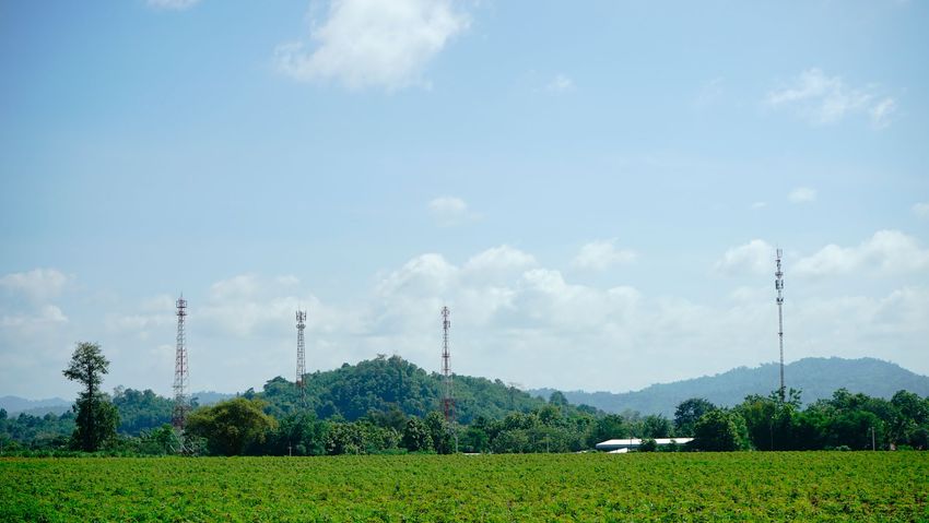
The need for climate resilience

1   The need for
    climate resilience
    and closing the
    weather data gap

    Smallholder farmers are facing a growing number of challenges
    due to climate change. This section outlines recommendations
    to address these challenges, and identifies areas in which digital
    services can play a key role. It highlights the gap in surface weather
    observations data common in low- and middle-income countries
    (LMICs), and how CML data from mobile networks provides a
    significant opportunity for MNOs to close this gap.

                                                                             1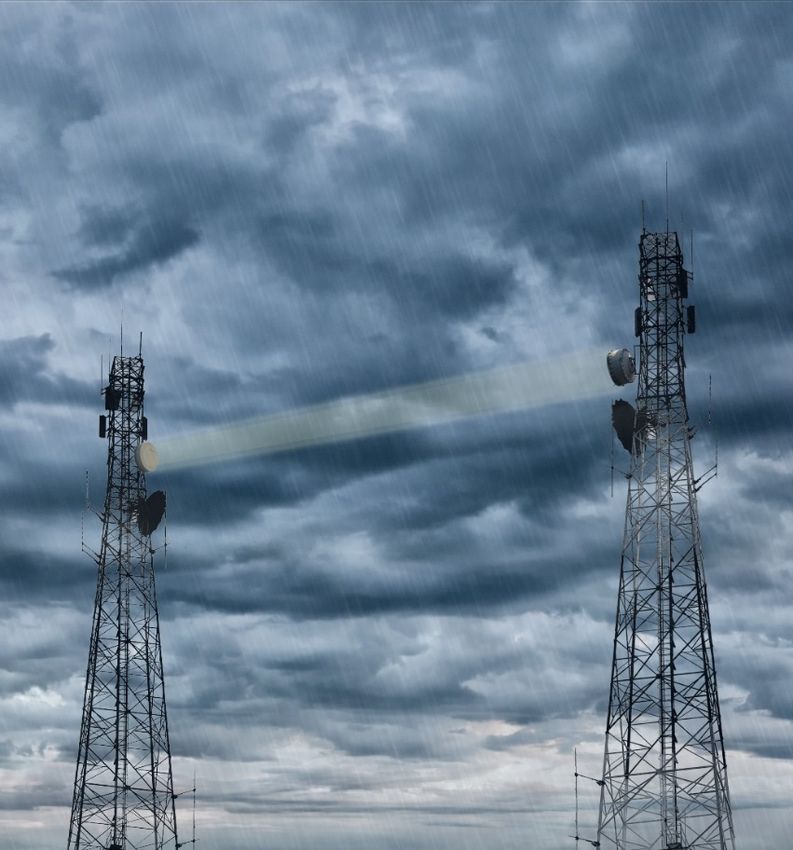
The need for climate resilience
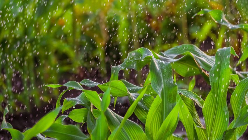
An increasingly volatile climate challenges smallholder farming systems
Increasingly volatile weather patterns
Increased food insecurity and
caused by climate change are posing Vulnerable smallholder production Increasingly volatile climate
livelihoods at risk
significant challenges for smallholder
farmers around the world. While • Globally, 500 million farms are two • Developing countries are • The number of people affected by
agriculture is an income source for an hectares or less.4 experiencing 20 per cent hunger has been rising since 2014.
estimated two-thirds of adults living more extreme heat now than In 2019, nearly one in ten people in
• Two-thirds of adults living in poverty
in poverty,5 they typically lack the in the late 1990s.1 the world were exposed to severe
generate at least some of their
resources to maximise yields and respond levels of food insecurity,9 in part
income through agriculture.5 • Areas exposed to serious
effectively to production challenges, due to climate shocks.
drought and flooding are
such as adverse weather conditions, crop • Smallholder agriculture in LMICs is
expected to increase by up to • Researchers estimate that climate
pests and disease. Financial services typically rainfed, including 90 per
44 percent by 2050.2 change will depress growth in
that would support these investments, cent in sub-Saharan Africa.6
global yields by five to 30 percent
such as agricultural credit, and formal • Higher temperatures reduce
• Access to agricultural insurance or by 2050.10
safety nets like agricultural insurance, are the amount of water available
other formal safety nets is limited. In
also not available to most smallholders. for crops by drying out • In some African countries, yields
Sub-Saharan Africa, it is estimated
It is estimated that areas exposed to air and soils, put stress on from rainfed agriculture may have
that less than three per cent of
extreme weather will increase by up to livestock, reduce labour declined by as much as 50 per cent
smallholder farmers are insured. In
44 per cent by 2050,2 with affected areas productivity and increase by 2020, with smallholder farmers
Asia, 22 per cent have insurance.7
experiencing reduced soil fertility and pests and diseases for both hit hardest.11
increased pest and disease pressures. • Inputs such as improved seed and livestock and crops.3
• Climate change is likely to raise
As a result, there is a risk that growth in fertiliser are not widely accessible,
food prices by 20 per cent12 for
global yields could decline by as much keeping adoption low. For example,
billions of low-income people.
as 30 per cent by 2050, driving up food the adoption rate of improved
prices and exposing millions more to food maize across Africa is approximately
insecurity and hunger. 28 per cent.8
2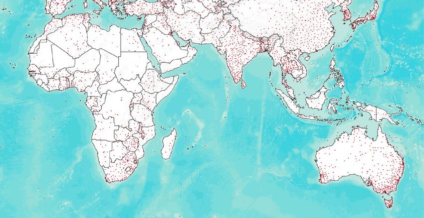
The need for climate resilience

            Climate risk mitigation strategies must address smallholder production
            challenges and support climate adaptation
To address climate change and achieve         while also ensuring the most vulnerable       Figure 1   Recommendations to support smallholder agriculture13
food security, systemic changes are           groups are not left behind.
needed in the global food system.13,14,15                                                      1   Improve smallholder productivity
                                              Advances in digital technologies are
Ensuring that smallholder farmers can                                                        • Boost research and development of good agricultural practices.
                                              addressing these challenges by making
become resilient to climate change while
                                              digital services increasingly available        • Expand extension services, including digital agricultural services, weather and
also increasing productivity will require
                                              to smallholder farmers. Digital advisory         seasonal forecasts.*
action on several fronts (see Figure 1).
                                              services have thrived due to the rapid         • Improve the availability of climate-adapted crop varieties.
Climate resilience refers to the ability
                                              penetration of mobile phones in LMICs,
of farmers to adapt to shifting climatic
                                              as well as weather and climate data
conditions, and anticipate and take steps                                                      2   Help farmers manage more variable weather and climate shocks
                                              that support tailored messaging to local
to mitigate the effects of extreme weather
                                              conditions. Agricultural insurance services    • Stimulate income diversification.
events brought about by climate change.
                                              are reaching scale with a shift to index-
                                                                                             • Strengthen social security systems.
Recommendations to support smallholder        based services that use data from remote
agriculture address both existing             sensors and other sources. Policy and          • Provide crop and livestock insurance.*
productivity challenges and new               donor decisions can now be informed by
challenges presented by climate change.       macroagricultural intelligence services          3   Address the challenges of the most affected and vulnerable farmers
Productivity challenges need to be met        that draw on big data and use machine
with better knowledge of climate‑smart        learning to identify vulnerable areas and      • Improve rights and access to resources for women farmers.
practices, relevant agricultural advisory     model the outcomes of interventions.           • Support pastoralists with climate adaptation.
and greater availability of more                                                             • Provide transition funds for the most-affected populations.*
productive, climate-adapted crop
varieties. The resilience of smallholder
farmers will depend on their ability                                                           4   Make climate-smart agricultural interventions
to diversify their income streams and                                                        • Facilitate climate-smart decision making.*
access safety nets, such as social security
systems and agricultural insurance.                                                          • Support synergies between climate adaptation and mitigation.
Agricultural interventions should take the                                                   • Adopt measures to conserve land and water resources
reality of a changing climate into account
                                                                                            * Recommendation can be directly addressed through digital services

                                                                                                                                                                                 3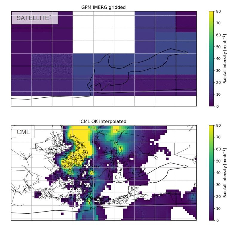
The need for climate resilience

            A key MNO asset, CML data from mobile networks can help close the
            weather observation gap in LMICs
While innovations in digital technologies      where extensive data sets for validating     Figure 2   Distribution of surface weather observations16
have helped advance digital climate            rainfall data from CML are available.
resilience services, they have not yet         Recognising the potential of this
reached their potential or achieved            approach in LMICs, a number of studies
scale. There are several obstacles. Since      followed that demonstrated the validity
weather observations are a vital part of       and potential of the technique in tropical
climate-resilience services, the lack of       markets, the first of which was in Burkina
surface weather (Figure 2) and radar           Faso.20
observations in many LMICs hinder the
                                               Commercial applications of CML-based
creation of accurate, localised forecasts
                                               rainfall observation remain limited.
and derivative services.
                                               US-based ClimaCell is one of the
CML data from mobile networks has              few organisations to use CML data in
the potential to narrow the weather            weather services. Ericsson is working
observations gap. CML data provides            in collaboration with the Swedish
information on the signal strength             Meteorological and Hydrological
of microwave links that transfer data          Institute (SMHI) to develop CML-based
between mobile base stations. As it rains,     services through its Ericsson One
this signal weakens, and these variations      Weather Data Initiative. The GSMA is
in signal strength can be used to calculate    working with Wageningen University &
the intensity of rainfall.                     Research (WUR), the Royal Netherlands
                                               Meteorological Institute (KNMI) and Delft      This report examines how digital services can support climate resilience for
Early CML research focused on the
                                               University of Technology (TU Delft) to         smallholder farmers, and how these services are created and delivered. It outlines
underlying principles of rainfall estimation
                                               develop CML-based rainfall data services       the opportunity for MNOs to employ mobile networks as rain sensors through
and establishing a proof of principle.17,18
                                               in collaboration with MNOs that can            the use of CML data. Use cases likely to benefit most from MNO involvement are
Once established, numerous studies
                                               be used in the development of climate          highlighted, as well as business models that could support mutually beneficial
applied this principle to larger CML
                                               resilience services.                           partnerships to develop climate resilience services.
data sets from high-income temperate
countries, such as the Netherlands,19

                                                                                                                                                                                   4
The need for climate resilience
Methodology: This study combines insights from key informant interviews
and secondary research with experience from GSMA-supported pilots
This report combines Secondary research Primary research
findings from secondary
• The GSMA maintains a tracker of active digital • Semi-structured key informant interviews climate resilience services. The GSMA’s
research (literature
agricultural climate resilience services. These services (KIIs) were conducted by telephone current engagements in these markets
review) with key
are defined as those that have scaled beyond the throughout 2020 with 33 organisations, cover the technical work to create data
informant interviews
pilot stage and have been active for over a year (this including private and public weather services using CML data for rainfall
(KIIs) and experience
currently includes over 140 organisations). The tracker service providers, agricultural intelligence estimation, and piloting the use of this
from GSMA-supported
is a subset of the GSMA’s AgriTech Services Tracker1 and advisory providers, agricultural data in climate resilience services. These
pilots.
(covering over 700 services as of January 2021) and insurance providers, agritechs, academia, projects will run from 2020 to 2022,
is kept up to date with ongoing secondary research international agencies and multilateral funded by the UK’s FCDO (Nigeria, Sri
that draws on industry publications (e.g. The Technical organisations. Interviewees were Lanka) and Australia’s DFAT (Papua
Centre for Agricultural and Rural Cooperation identified from GSMA AgriTech’s climate New Guinea), with WUR, KNMI and TU
(CTA), Global Commission on Adaptation (GCA), services tracker and other secondary Delft as the main technical partners.
World Bank, World Meteorological Organization), research sources for individuals from
• In Sri Lanka, the GSMA, in partnership
donor and international NGO websites (CCAFs, non-service organisations. For service
with Dialog Axiata Sri Lanka (Dialog),
CGAP, MercyCorps, UK Foreign, Commonwealth & providers, the goal of the interviews
WUR and KNMI, collected and analysed
Development Office), as well as snowball sampling was to understand the scope of
3.5 months of CML data to demonstrate
from informant interviews. Additional sources include services offered, how the services were
the potential of CMLs for real-time
service provider websites, relevant case studies and developed (especially data sources and
tropical rainfall monitoring. This
semi-structured interviews (see Primary research). analysis), the underlying business model
study represents the most extensive
Geographically, the research focused on markets and their roadmap for the future.
evaluation of CML data in tropical
where the GSMA AgriTech programme has a presence:
• Lessons from the GSMA’s engagements markets in terms of spatial and temporal
Sub-Saharan Africa, South Asia and Southeast Asia.
with MNOs in Nigeria, Sri Lanka and coverage. The findings inform the
• Academic research was used where relevant, Papua New Guinea inform section 2 assessment of CML data in section 2.21
primarily to capture developments in rainfall on the use of CML data for rainfall
estimation from CML, and included journal articles estimation, as well as section 4, which
from Science, Atmospheric Measurement Techniques outlines potential business models and
and Geoscientific Model Development. partnerships to integrate MNO assets in
5The need for climate resilience
Endnotes
1 FAO et al. (2018). The State of Food Security and Nutrition in the World 2018. 13 GCA. (2019). Adapt Now: A Global Call for Leadership on Climate Resilience.
2 World Bank. (2014). Turn Down the Heat: Confronting a New Climate Normal. 14 WRI. (2018). Creating a Sustainable Food Future.
3 Global Commission on Adaptation (GCA). (2019). Adapt Now: A Global Call for 15 FAO. (2019). Agroecological and other innovative approaches for
Leadership on Climate Resilience. sustainable agriculture and food systems that enhance food security and
nutrition. HLPE Report 14.
4 Lowder, S., Skoet, J., and Raney, T. (November 2016). “The Number, Size,
and Distribution of Farms, Smallholder Farms, and Family Farms Worldwide”,
World Development, 87, pp.16–29.
16 NOAA, Integrated Surface Dataset: https://data.noaa.gov/dataset/dataset/
5 Castañeda, A. et al. (2018). “A New Profile of the Global Poor”, World integrated-surface-dataset-global
Development, 101, pp. 250–267.
17 Leijnse, H., Uijlenhoet, R. and Stricker, J.N.M. (2007). “Hydrometeorological
6 Cooper, P. and Coe, R. (2011). “Assessing and Addressing Climate-induced application of a microwave link: 2. Precipitation”, Water Resources Research.
Risk in Sub-Saharan Rainfed Agriculture”, Experimental Agriculture.
18 Messer, H., Zinevich, A. and Alpert, P. (2006). “Environmental monitoring by
7 Shakhovskoy, M. and Mehta, R. (17 September 2018). “Protecting growing wireless communication networks”, Science, 312(5774), p. 713.
prosperity: Agricultural insurance in the developing world”, Rural and
19 Overeem, A., Leijnse, H. and Uijlenhoet, R. (2013). “Country-wide rainfall
Agricultural Finance Learning Lab.
maps from cellular communication networks”. Proceedings of the National
8 Langyintuo, A.S. et al. (2010). “Challenges of the maize seed industry in Academy of Sciences U.S.A.
eastern and southern Africa: A compelling case for private–public intervention
20 Doumounia, A. et al. (2014). “Rainfall monitoring based on microwave links
to promote growth”, Food Policy 35(4), 323–331.
from cellular telecommunication networks: First results from a West African
9 FAO et al. (2020). The State of Food Security and Nutrition in the World 2020. test bed”, Geophysical Research Letters.
10 World Bank. (2013). Turn Down the Heat: Climate Extremes, Regional
Impacts, and the Case for Resilience.
21 Overeem, A. et al. (2021). “Tropical rainfall monitoring with commercial
11 IPCC. (2007). AR4 Climate Change 2007: Synthesis Report. Contribution microwave links”. Forthcoming publication
of Working Groups I, II and III to the Fourth Assessment Report of the
Intergovernmental Panel on Climate Change.
12 Nelson, C.C., et al. (2014). “Climate Change Effects on Agriculture: Economic
Responses to Biophysical Shocks.” Proceedings of the National Academy of
Sciences of the United States of America
6Digital services for smallholder climate resilience
2 Digital services
for smallholder
climate resilience
This section highlights the range of digital services that can have
a direct impact on the climate resilience of smallholder farmers. It
introduces three categories of use cases that will be the focus of
this report: weather and climate information services, data-driven
agricultural services and agri digital financial services. Finally, it
identifies the unique assets that MNOs could use to develop and
deliver these services in innovative and efficient ways.
7Digital services for smallholder climate resilience
Weather and climate services, data-driven agriculture and agri digital financial services
have the greatest potential to positively impact smallholder climate resilience
Digital technologies enable a range of services Data-driven agriculture services (DDAS) use Figure 3 Digital agriculture use cases and sub-use cases1
that can mitigate the challenges smallholder localised and timely data to create information
farmers face, and help agricultural value chains and advisory services for agricultural value Access to services Access to markets Access to assets
function better, especially in the last mile.1 The chain actors. Agricultural intelligence services
GSMA has grouped digital agricultural solutions monitor and predict agricultural activities Agri digital
into three broad categories of access and five to support decision making for a variety of Digital Digital Agri
financial Smart farming
advisory procurement e-commerce
categories of use cases2 (see Figure 3). organisations. Climate-smart agri advisory services
builds on traditional agricultural advisory
This report focuses on three categories of
services by incorporating local and timely data
services that allow farmers to directly mitigate
to tailor advisory messages to farmers’ current
the impacts of long-term climate change,
farm conditions. Precision agriculture uses
short-term climate shocks and extreme
hyperlocal data sources, such as sensors and
weather events: 1) weather and climate
UAV imagery, to optimise on-farm activities,
services (WACS), 2) data-driven agriculture
and may involve elements of mechanisation,
services (DDAS) and 3) agri digital financial
such as solar irrigation.
services (agri DFS). These services fall under
the use cases of digital advisory and agri Agri digital financial services (Agri DFS)
digital financial services. include agricultural credit and agricultural Weather and Climate Data-driven agriculture Agri digital financial
insurance that can help smallholder farmers Services (WACS) services (DDAS) services (Agri DFS)
Weather and climate services (WACS) are
become more resilient to climate change.
advisory services that provide valuable and Weather nowcasts Agricultural intelligence Agricultural credit
Agricultural credit includes digitally enabled
actionable information to smallholder farmers
credit products that smallholders can use Climate-smart agri
on changing weather conditions. The three Weather forecasts Agricultural insurance
to access agricultural assets, inputs and advisory (CSAA)
sub-use cases of weather nowcasting, weather
services. Index insurance refers to insurance
forecasts and climate prediction represent Climate prediction Precision agriculture
that relies on the modelling and monitoring
services that extend further into the future,
of observable phenomena (such as rainfall) to
and therefore require different data sources Early warnings Early warnings
determine insurance costs and pay‑outs.
and modelling approaches.
8Digital services for smallholder climate resilience
Digital agriculture plays an important role in climate resilience, from
long-term adaptation to short-term responses
Adaptation to climate change can take place when Throughout the cropping season, weather forecasts, Agriculture contributes to climate change by producing
farmers are aware of the longer term shifts in climate nowcasts and early warnings provide advance warning of greenhouse gas (GHG) emissions, primarily through
affecting them, and have the resources to adopt adverse events, allowing farmers to respond to changing livestock production and deforestation.3 Agri-intelligence
practices that will maximise their productivity in this meteorological conditions where possible. services can monitor land use changes, alert relevant
new context. Climate prediction and climate-smart authorities to deforestation activities4 and allow
In the case of adverse weather events, such as droughts
agri advisory provide the information farmers need to agribusinesses to identify risk in their supply chains.
or heavy rainfall, insurance provides a safety net for
understand climate change and the implications for Together, these services can reduce the net carbon
famers to recover some of their production costs or lost
local agriculture. In the medium term, seasonal weather emissions of agriculture and contribute to climate change
income. Similarly, agricultural credit can be a catalyst for
forecasts allow farmers to select appropriate climate- mitigation. Meanwhile, agricultural credit can enable
recovery, allowing farmers to invest in agricultural inputs
adapted crops and varieties, and plan their agricultural smallholder farmers to shift to more sustainable farming
for the next season after suffering losses in the last.
activities. practices through increased access to inputs and assets, and
therefore reduce the need to expand their cultivated land.
Figure 4 The role of digital services in managing climate change
Approaches to managing Weather and climate services Data-driven agriculture services Agri digital financial services
climate change (WACS) (DDAS) (Agri DFS)
LONG
TERM Mitigation Agricultural intelligence Agricultural credit
Agricultural intelligence
Climate prediction
Adaptation Climate-smart agri advisory Agricultural credit
Weather forecasts
Precision agriculture
Weather nowcasts Early warnings
Response
Early warnings (weather) (crop pests and disease)
Agricultural insurance
SHORT Recovery
Agricultural credit
TERM
9Digital services for smallholder climate resilience
Weather and climate services allow smallholders to anticipate and respond
to climate events and can enable adaptation to long-term climate change
Meteorological services, which include WACS, provide WACS are typically considered public goods and are the general public and weather-dependent sectors. The
information and advice on the past, present and future provided by National Meteorological and Hydrological increased availability of openly available satellite weather
state of the atmosphere. This includes information Services (NMHSs). The role of NHMSs has typically data has also fostered innovation in the private weather
on temperature, rainfall, wind, cloudiness and other been to operate a network of weather stations, produce sector. For example, innovative forecasting techniques
atmospheric variables and their influence on weather- and weather forecasts for the general public and specialised and delivery models are used to provide end-user services
climate-sensitive activities and communities.5 Depending forecasts for relevant sectors. As satellite and private (e.g. Ignitia), and proprietary technologies are used to
on the timescale, different services can be used to support weather data have become more available, and global collect local weather data to refine forecasts (e.g. Earth
smallholder climate resilience. These are outlined in forecasting models can be used as the basis for regional Networks, ClimaCell).
Figure 5 below. and local forecasts, NHMSs are slowly shifting to focus
on the localisation and dissemination of forecasts for
Figure 5 Temporal coverage of weather and climate services5
PAST -1 year Now +6 hours +1 month +1 year FUTURE
Historical observations Recent observations Nowcasting Weather forecasting Seasonal forecasting Climate prediction
Weather observations Weather nowcasting Weather forecasts Climate predictions
Weather observations include data from Weather nowcasting provides high-resolution Weather forecasts use numerical models that Climate predictions provide an estimate of
numerous sources of key atmospheric variables, rainfall forecasts up to six hours in advance forecast the behaviour of atmospheric processes climate more than one month into the future, at
such as temperature, humidity, wind speed and based on radar observations that are spatially based on initial conditions up to one month into seasonal, interannual or long-term timescales.
direction and atmospheric pressure at various extrapolated into the future.6 the future.
Predictions enable seasonal planning by
altitudes. This data is captured by remote
Nowcasts enable short-term responses that Forecasts enable short-term planning by smallholder farmers, including which crops to
sensing, weather balloon and land and marine
reduce the impact of climate events, such as agricultural value-chain actors to optimise input grow and planting/harvesting dates. Macro-level
weather stations.
storms and heavy rainfall. use and timing of agricultural activities, and to actors can identify potential issues and take
Historical weather observations enable analysis anticipate pest and disease outbreaks. mitigating measures.
of long-term weather trends, and are key inputs
for financial services, such as weather index
insurance actuarial models and agricultural credit Early warnings
risk assessments.
Early warnings are predictions or forecasts of hazardous or dangerous weather Early warnings enable short-term responses to reduce the impact of climate
conditions, such as flooding, droughts, high winds, extreme heat and cold, that events, both by micro-level actors, such as smallholder farmers, as well as public
pose an immediate or serious threat to life, property or livelihoods. Creating institutions and NGOs.
early warnings may require additional information on underlying factors (e.g. soil
saturation, water levels). 10Digital services for smallholder climate resilience
Case studies: Weather and climate services
Ignitia Earth Networks
Ignitia is a specialist tropical weather forecaster based in Sweden Earth Networks is a US-based private weather forecaster
with offices in Ghana and Nigeria. iska™, the company’s flagship that provides cloud-based weather data services to a range
service, provides localised daily, monthly and seasonal weather of enterprise customers around the world, including national
forecasts via SMS to smallholder farmers in Ghana, Nigeria, Burkina meteorological and hydrological services. Services include weather
Faso, Mali and Ivory Coast. data APIs and dashboards, as well as decision-making support
systems.
The service relies on an advanced tropical numerical weather
prediction model developed by Ignitia that draws on various Earth Networks integrates data from global numerical weather
data sources, including satellite data, global numerical weather prediction models, their own global network of weather sensors
prediction models and lightning detection to provide more accurate and weather observations from other sources to provide
and higher resolution forecasts. localised forecasts. Machine learning processes use local weather
observations to fine-tune forecasting models to specific locations,
Ignitia markets their services under a subscription model. They
enabling accurate local forecasting. Earth Networks partners with
partner with local MNOs under revenue-sharing arrangements to
mobile networks to co-locate weather sensors with mobile base
distribute their messages and rely on them to provide subscriber
stations to expand their observations network.
location from call detail records. Ignitia has partnered with MTN
in Ghana and Ivory Coast, 9Mobile in Nigeria, and Orange in Mali In LMICs, Earth Networks works across the public, private and
and Burkina Faso. Alternatively, Ignitia works with NGOs that cover civil sectors. For example, they have a partnership with Viamo, a
subscription costs and provide the farmer registration data they provider of digital advisory services, to include weather forecasts
need to deliver the service. through its 3-2-1 platform in 11 countries in Africa and Asia. In the
Philippines, Earth Networks has partnered with PAGASA, the public
weather service provider, to install and run a nationwide weather
monitoring network.
11Digital services for smallholder climate resilience
Data-driven agricultural services provide evidence-based decision-making
support to agricultural stakeholders
Data-driven agricultural services (DDAS) use near real- Figure 6 DDAS use cases
time data sources to make predictions and provide
MACRO Agricultural intelligence
advice on agricultural activities. These services build on
conventional advisory services by considering a user’s Agricultural intelligence services are data analytics Long-term trend analysis is used to assess value
location and current local agrometeorological conditions solutions that integrate satellite, agronomic, chain risk and identify longer term adaptation
to tailor models and advice. weather and climate and market data, and convert strategies. Agricultural intelligence services also
this information into useful country- and value contribute valuable inputs to financial services,
As satellite observations, Internet of Things (IoT) chain-level insights for government policymakers, including risk assessments for agricultural credit
networks and low-cost sensors have become more agribusinesses and financial actors. and actuarial modelling and index monitoring for
available, and machine learning and computing agricultural insurance.
Services include monitoring agricultural activity,
technology more advanced, there has been a including land use, growth assessments, yield
proliferation of data-driven agricultural service providers forecasting and pest and disease early warnings.
around the world.
Climate-smart
Digital climate agri advisory
advisory services
DDAS use the same approach to provide solutions
to a variety of end users. By integrating data from CSAA provide information on agronomic best These services enable smallholder farmers to
diverse sources, from satellite imagery to soil sensors, practices, pests and diseases and weather and maximise their agricultural production and revenues
market prices to smallholder farmers through by selecting the most appropriate inputs, optimising
DDAS create models of current and future agricultural
digital channels. They draw on weather and climate agricultural practices, and responding to crop pests,
activity. These models can be used for various use cases forecasts, as well as spatial agronomic data such as disease and extreme weather events in a timely and
depending on the end user and available data sources soil maps, to tailor advisory messages to local and effective manner.
(see Figure 6). seasonal conditions.
As use cases move from the macro- to micro-level, data
demands increase. This is because localised sources of Precision agriculture
data, such as ground-level sensors, are needed to create Precision agriculture services bring intelligence and This shift from general to more specific data enables
farm-specific models, and farm-level data on agricultural advisory services to the farm level by utilising farm- more tailored recommendations to optimise crop
practices is needed to tailor advisory messages. specific agronomic data, such as on-farm sensors, choices, input use and good agricultural practices,
soil analysis and high-resolution remote sensing data and ultimately maximise agricultural productivity.
from unmanned aerial vehicles (UAVs) or private
satellite providers.
MICRO
12Digital services for smallholder climate resilience
Case studies: Data-driven agriculture services
aWhere SunCulture
aWhere is an agricultural intelligence provider based in the US, but SunCulture provides solar-powered irrigation solutions to farmers in
operating globally. They offer a range of solutions that enable data- Africa from their base in Kenya. The company combines innovative
driven decisions on adapting to changing weather conditions on a hardware with Pay-As-You-Go (PAYG) financing models to make
local and global scale. Data APIs and an online platform are their core irrigation accessible to smallholder farmers. Their equipment is
services, which provide agriculturally relevant weather conditions, bundled with tailored advice and generates intelligence around
historical trends, crop models and pest and disease predictions, customer usage through integrated IoT devices. Installation, training,
among other information. and after sales support is included with their products.
aWhere’s weather and agronomic data can integrate with other They are currently building their IoT capacity to provide precision
geospatial data such as soil maps, watersheds, and livelihood advisory services. Using Microsoft’s Azure platform, they integrate
zones as well as population data to provide additional insight. With usage data collected from their devices with complementary data,
historical observed data going back to 2006, aWhere’s customers such as weather observations and forecasts to model how particular
can analyse historical weather trends and develop crop models. usage patterns result in better yields. These models will enable the
provision of tailored advisory messages to customers via SMS. The
Services are provided through a freemium subscription model,
addition of customer payment behaviour to this dataset enables the
allowing free access to basic data points and tiered access to the
creation of repayment profiles, which represents highly valuable data
complete dataset. aWhere has subscribers in public agencies in
to lenders and insurers, and allows SunCulture to develop a range
Kenya, Uganda and Zambia that use their platforms for weather
of higher value productive appliances for more affluent customer
forecasting and decision making. In Kenya, they have worked with
segments.
Safaricom and MercyCorp’s AgriFin programme to develop a bespoke
agronomic advisory service for smallholder farmers delivered as SunCulture irrigation systems are marketed directly to customers
part of the DigiFarm platform. In Ghana, Esoko uses the aWhere through phone sales channels, regional sales and support centers,
API to access the weather data they need to provide climate-smart and a network of field sales agents in Kenya.
agronomic advice.
13Digital services for smallholder climate resilience
Agri digital financial services provide a safety net following adverse weather
events and stimulate adoption of climate-smart inputs and assets
The traditional hurdles to financial services for
smallholder farmers, mainly the high costs of assessing Agricultural credit Agricultural insurance
individual farm risk and creditworthiness, are slowly
being removed as digital data sources are used to The increasing availability of digital data on Agricultural index insurance uses digital data
replace or approximate individual farm assessments. farmers’ economic and agronomic activity, sources, such as automated weather stations
combined with the growth of digital service and remote sensing data, as the basis for
In the insurance industry, index or parametric insurance
delivery channels, are making formal agricultural risk and claims assessment. This makes them
is increasingly replacing indemnity models as they
credit services increasingly scalable to cheaper and more scalable than traditional
are proving to be more cost-effective and scalable.
smallholder farmers. insurance that requires farm visits to assess
By relying on secondary data sources, such as weather
premiums and claims.
observations for actuarial modelling, claims assessment Farmer credit scores and risk assessments
costs are greatly reduced. can now be created using data on farm size, Digital data sources typically include
farmer assets and income streams, reducing agriculture-related data, such as rainfall,
Similarly, with the increasing digitisation of payments
or eliminating the need for face-to-face evapotranspiration9 or NDVI.10 Historical indices
and transactions in agricultural value chains, smallholder
assessments (e.g. FarmDrive). Approved credit are calculated to determine normal conditions,
farmers are building financial histories that can be
can be paid and repaid using digital vouchers or and pay-outs are based on deviations from
used for loan risk assessments and credit scoring. This
mobile money transfers, further reducing costs. those conditions.
significantly reduces the manual due diligence required
by financial service providers to provide agricultural Short-term credit products give smallholder In the face of adverse weather events, weather
credit services. farmers access to improved inputs, such index insurance can make the difference
as high-yielding or drought-resistant crop between being able to replant a crop that
Digital communication channels and mobile money
varieties. Long-term loans, with payment terms did not germinate (e.g. due to a lack of early
services have also played a key role in facilitating
built around a farmer’s cash flow, can enable rains) or replace lost income at the end of an
financial services. As mobile phone ownership increases
investment in assets that enhance productivity, unproductive season. With insurance, farmers
among smallholder farmers, mobiles can serve as both
such as irrigation. are able to cover their expenses and invest in
a marketing platform and payment/pay-out channel for
the next season’s crop.
digital financial products.
14Digital services for smallholder climate resilience
Case studies: Agri digital financial services
FarmDrive Oko
FarmDrive is a Kenyan tech start-up that specialises in credit scoring Oko is a weather index insurance provider operating in Mali and
for smallholder farmers. Their services bridge the gap between Uganda. Specialising in the development of index insurance using
smallholder farmers and financial institutions, making agricultural remote sensing data, they partner with local insurance providers for
financing available to groups that have traditionally been excluded underwriting. Oko markets their products directly to smallholder
from the formal financial system. farmers or through other players in the agricultural value chain.
FarmDrive collects information directly from farmers and combines it Oko uses publicly available data from the geostationary MeteoSat
with relevant agronomic data, such as satellite imaging, soil analysis satellites via TAMSAT on cumulative rainfall, as well as NDVI and
and weather forecasts, to assess credit risk. Credit providers can evapotranspiration, combined with historical yield data, where
use the information provided by these models to make informed available, to create actuarial models and monitor insured risks. This
lending decisions, and use FarmDrive’s digital platform to reach rural provides a scalable quantification of risk and automated verification
customers directly. of claims and pay-outs. Insurance products are made available
through apps and USSD, allowing them to be distributed to remote
FarmDrive partners with financial service providers to make
locations.
innovative agricultural credit products available to smallholder
farmers. In Kenya, they work with Safaricom to launch DigiFarm In Mali, Oko has partnered with MNO Orange to offer weather index
Loans through Safaricom’s mobile value-added services platform for insurance through Orange’s USSD menu. This has created a fully
rural customers. digital insurance service that farmers can access and pay for using
their mobile phone.
15Digital services for smallholder climate resilience
MNOs have a range of assets that enable localised and scalable climate
resilience services
Digital technologies have been key enablers of innovation Existing mobile network infrastructure can support the Mobile money channels enable innovative payment
and service development in all three categories of climate collection of local, ground-level weather observations models, such as micropayments for asset financing (e.g.
resilience services (weather and climate services, data- through the use of CML data (section 2 takes an in-depth M-Kopa, SunCulture), which allow farmers to access credit
driven agriculture services, and digital agricultural financial look at CML data) or by co-locating automated weather products and services that were previously unattainable.
services). MNO assets, from technical infrastructure stations with mobile base stations. These observations fill For insurance, mobile money enables digital marketing
to communications channels, existing customer bases a crucial gap in LMICs where weather radar and weather and repayment of insurance policies, eliminating the need
and agent networks, have the potential to support even station networks are typically lacking. This data can be for face-to-face and cash transactions. MNOs can also
greater innovation and scale climate resilience services. used by weather forecasters to localise global models, by help alleviate bottlenecks in user registration. Collecting
DDAS providers to improve agronomic models and by Know Your Customer (KYC) and location data remains
insurance providers to provide agricultural insurance to problematic for service providers, but MNOs may already
previously unserved areas. have this data for their existing customers.
Data collection Analysis Service design Service delivery
Digital technology service enablers
• Automated weather stations (AWS) • Artificial intelligence approaches • Geographic information systems (GIS) platforms • Mobile aggregators (SMS/IVR)
• Internet of things (IoT) enabled sensors • Open-source analysis software and libraries • Data-as-a-service (DaaS) • Smartphone apps
• Remote sensing imagery and data (satellite, drone) (e.g. Python, R) • Software-as-a-service (SaaS) • Online platforms and services
• Open data sources (e.g. Africasoils.net, APHLIS.net) • Global numerical weather models (e.g. GFS, ECMWF) • Social media and chat
• Mobile data collection (e.g. ODK) • Serverless computing (e.g. Azure, AWS) • Application programming interfaces (APIs)
• Cloud data analysis platforms (e.g. Azure FarmBeats)
MNO value-add
• CML data for rainfall observations • Bundling of complementary services • Digital services platforms
• Siting AWS with mobile base stations • Mobile money enabled payments and payment • Agent networks
• Connectivity (data, IoT) models (e.g. pay-as-you-go) • Mobile delivery channels: SMS, USSD, IVR
• Registration data (location, KYC) • Disbursement of credit via mobile money or • Cell broadcast
digital vouchers
• Mobile (money) usage data
Legend: Data sources Technical infrastructure Marketing and distribution assets
16Digital services for smallholder climate resilience
Endnotes
1 In agricultural value chains, the “last mile” is the web of relationships and
transactions between buyers of crops, such as agribusinesses, cooperatives
and intermediaries, and the farmers who produce and sell the crops.
2 GSMA (2020). Digital Agricultural Maps.
3 WRI. (2018). Creating a Sustainable Food Future.
4 GSMA (2020). Digital Dividends in Natural Resource Management.
5 WMO. (2015). Valuing Weather and Climate: Economic Assessment of
Meteorological and Hydrological Services.
6 Wang, Y. et al. (2017). Guidelines for Nowcasting Techniques. WMO
7 Tsan, M. (2019). The Digitalisation of African Agriculture 2018–2019. CTA.
8 GSMA (2020). Agricultural insurance for smallholder farmers: Digital
innovations for scale.
9 Evapotranspiration measures water loss through leaves, which is proportional
to plant growth and crop yield. Evapotranspiration monitoring is done by
modelling remote sensing data.
10 Normalised difference vegetation index (NDVI) quantifies the density of
plant growth in a given area by measuring the reflectivity of the surface using
remote sensing imagery.
11 Alley, R., Emanuel, K.A. and Zhang, F. (25 January 2019). ”Advances in
weather prediction”, Science 363(6425), pp. 342–344.
17Measuring rainfall using mobile networks
3 Measuring rainfall
using mobile networks:
commercial microwave
links (CML) data
Existing mobile network infrastructure presents a unique opportunity
to gather data that can support near real-time rainfall observations in
countries with limited ground-level weather observations. This section
describes the principles and potential of CML-based rainfall observation,
and compares CML rainfall estimation to other precipitation data sources.
It concludes by outlining the opportunity for MNOs to develop CML rainfall
services through the addition of software to their network hardware.
18Measuring rainfall using mobile networks
Existing mobile communications networks can be used to observe rainfall
events at high resolution by monitoring fluctuations in signal strength
Given the lack of reliable ground-level Along microwave links, radio signals
measurements, there is an opportunity for propagate from a transmitting antenna
MNOs to add significant value to a range at one mobile base station to a receiving CML rainfall observation
of weather monitoring and forecasting antenna at another base station. When it
services. Recently, MNOs have begun rains, water absorbs and scatters these Principles
using CMLs as virtual weather sensors to microwave signals, reducing the signal
• M
obile backhaul networks use microwave signals (CMLs) to
monitor and map rainfall measurements. strength between the transmitting cell
connect base stations
CMLs are close-to-the ground radio phone towers. By comparing signal
connections used worldwide in cellular levels to those representative of dry • R
ainfall reduces microwave signal strength between stations,
telecommunication backhaul networks. In weather, CML data can be analysed and reductions are captured in CML data
telecommunications, backhauling refers converted into highly accurate rainfall • CML data is collected by MNOs to monitor service quality
to the connections and links between the measurements, effectively turning the
core or backbone network and the small mobile network into a virtual network
sub-networks at the edge of the network. of rain gauges. Commercial weather Process
companies such as ClimaCell,1 and 1 2 3
technology companies such as Ericsson
and its Weather Data Initiative,2 have
developed their own proprietary
algorithms to analyse this data and
develop weather-related services.
An open source algorithm, known as CML data is Algorithms Rainfall intensity
RAINLINK, has also been developed as extracted from the calculate rainfall is interpolated
part of a joint initiative between WUR mobile network, intensity from signal onto a spatial grid,
and KNMI.3 typically every strength reductions typically 1 km2
15 minutes
19Measuring rainfall using mobile networks
Mobile networks cover over 90 per cent of the population in most LMICs,
with less coverage in rural areas
Most countries in Sub-Saharan Africa, South Asia and In rural areas, network coverage is more limited as data quality because rainfall calculation algorithms use
Southeast Asia have mobile networks that cover over population density decreases. This is illustrated by the interpolation techniques that take density into account.5
86 per cent of the population (Figure 7), indicating example of MNO Tigo in Tanzania (see Figure 8). While For agricultural use cases, this coverage is a significant
extensive national backhaul coverage. It is estimated that 95 per cent of the population in Tanzania is covered by improvement and indicates that significant agricultural
by 2023, around 65 per cent of radio sites in the world a mobile signal, large uninhabited parts of the country areas in LMICs are covered by CML links.
will be connected by microwave (excluding Northeast are not. In rural areas, backhaul networks also typically
Asia).4 This means there is a significant opportunity to become less dense and link lengths longer as fewer
use CML as virtual weather sensors to monitor and map connections need to be served. However, studies have
rainfall measurements. shown that lower link densities do not necessarily lower
Figure 7 Percentage of population covered by mobile signal6 Figure 8 Mobile network coverage of Tigo in Tanzania4
30–40 40–50 50–60 60–70 70–80 80–90 90–100
20You can also read