Downtown West Construction Impact Mitigation Plan April 2021
←
→
Page content transcription
If your browser does not render page correctly, please read the page content below
Downtown West
Construction Impact Mitigation Plan

April 2021

Prepared for:
City of San Jose
200 E Santa Clara St
San Jose, CA 95112
USA

Prepared by:
Google LLC
1600 Amphitheatre Parkway
Mountain View, CA, 94043

Project Team Contact:
Duanne Gilmore - duanne@google.com +1 650-499-1168
Preface:

A CIMP will be submitted for each phase or individual horizontal, vertical or open space project
within the Downtown West project area (“Subsequent CIMP”).

The Subsequent CIMPs for each project or phase of a project will be submitted to the City in
accordance with the following timing:
   ● For horizontal infrastructure projects or phases the Subsequent CIMP will be submitted to
      the City in draft at the 65% horizontal infrastructure design submission and finalized for
      the Encroachment Permit issuance.
   ● For vertical projects within a parcel or phase that has an existing Subsequent CIMP
      covering any impact to the surrounding right of way, the Subsequent CIMP specifically
      covering the impacts of the vertical construction will be submitted in draft at the Building
      Permit application and finalized for the Building Permit issuance.
   ● For Open Space projects, if not submitted as part of a vertical or infrastructure
      submission, the Subsequent CIMP will be submitted in draft at Building Permit
      Application, and finalized for the Building Permit issuance.

This framework document is intended to provide guidance for the content of each Subsequent
CIMP. The project information contained within this CIMP is derived from the EIR. As the
specific timing and construction methodologies for each project are not yet known, this
document cannot provide a description of the project impacts and mitigations at this stage.

A Recommended Temporary Traffic Control Plan (RTTCP), developed in accordance with San
Jose’s standards, is to be included as an Appendix to each Subsequent CIMP. Traffic impacts
identified in a RTTCP will be addressed in the Subsequent CIMP.

Each Subsequent CIMP may supersede an earlier plan, as each phase or sub-project is
commenced. If so, this is to be noted within each Subsequent CIMP.

A.       Project Description

City’s CIMP Policy: A detailed project description, including site maps and a phasing schedule
depicting the proposed location and timing of construction activity on a month-by-month basis for
the duration of the project.

Executive Summary

[This section will provide a broad description of the whole Downtown West project. Particularly
for the earlier Subsequent CIMP submissions, it will not be possible to provide a full and detailed
description of work on every subsequent site and within every geographical area of the
Downtown West project, as each individual building may not have completed the design phase.
The Project will provide all details known of the respective project to inform the City of the
overall approach to construction on the respective sites.]

Page 1
Google LLC, the project applicant, is proposing the Downtown West Mixed-Use Plan (proposed
project) as part of the company’s expansion of its workforce and business operations in the Bay
Area. To address workforce growth and create more efficient transportation linkages between the
Google workplace and employees’ homes, the proposed project is located in the Envision San
José 2040 General Plan (General Plan) Downtown Growth Area and largely within the boundaries
of the City of San José’s (City’s) Diridon Station Area Plan (DSAP), 1 which envisions a new
high-density job center anchored by public transportation. The proposed project would include a
mix of uses generally consistent with the General Plan and DSAP, providing for a mixed-use
Downtown neighborhood.
The proposed project consists of the demolition of most existing buildings on the project site and
phased development of new buildings on approximately 81 acres on the west side of Downtown
San José.
The proposed project would include development of the following uses:
● A maximum of 7.3 million gross square feet (gsf) of commercial office space
● A maximum of 5,900 residential units
● A maximum of 500,000 gsf of active uses (commercial retail/restaurant, arts,
cultural, live entertainment, community center, institutional, childcare and
education, maker spaces, non-profit, and small-format office space)
● A maximum of 300 hotel rooms
● A maximum of 800 limited-term corporate accommodations (lodging of company
workforce for not more than 60 consecutive days and not open to the public;
considered a non-residential use)
● A maximum of 100,000 gsf of event and conference space
● On- and off-street public/commercial and residential parking
● A district systems approach to delivery of on-site utilities including designated
infrastructure zones with on-site centralized utility plants totaling up to 130,000
gsf
● One or more on-site logistics centers to serve the commercial on-site uses that
would occupy a total of about 100,000 gsf
● A total of approximately 15 acres of parks, plazas, and open space, including
areas for outdoor seating and commercial activity (such as retail, cafes, and
restaurants), green spaces, landscaping, mid-block passages, riparian setbacks,
and trails Various improvements to the public realm to improve transit access
and pedestrian and bicycle circulation and facilitate connectivity, both within the
site and to and from surrounding neighborhoods.
Scope of work described by this CIMP
[In this section, we will describe the extent of work that is the subject of a particular Subsequent
CIMP. This is necessary because the project will be divided into a number of phases and
sub-projects by geographical area. Therefore, there will be multiple Subsequent CIMP
submissions covering the different phases of the project.
Each Subsequent CIMP will be submitted for approval to the City in accordance with the timing
stated in this CIMP. The applicant would therefore be able to demonstrate that it has an
approved Subsequent CIMP when submitting an encroachment permit application for each phase
of work.]
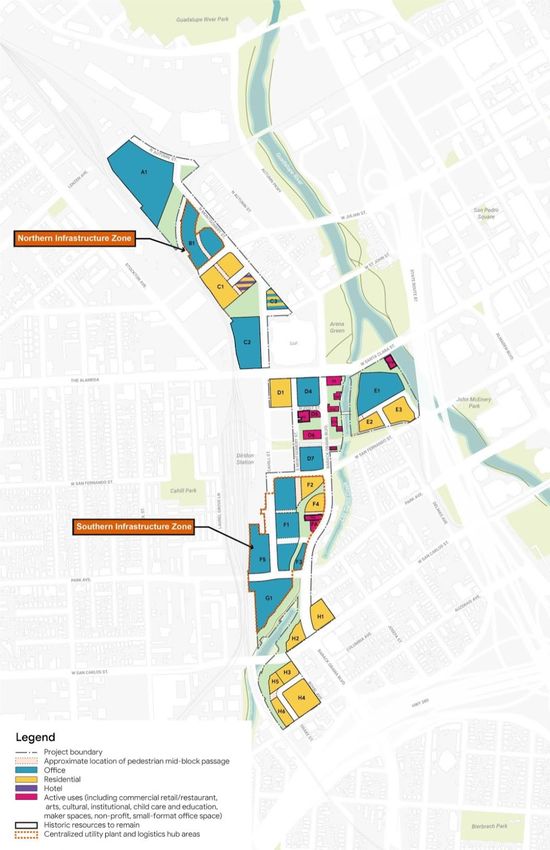
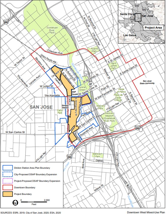
Page 2Site Map [This will show the overall Downtown West project area, and then highlight the specific geographical area that is the subject of this particular CIMP. It will also show any previously submitted/approved CIMP areas.] The project area is located in the western portion of Downtown San José, mostly within the DSAP. (The DSAP boundary would be amended to include the previously entitled project area west of Barack Obama Boulevard (formerly South Autumn Street) between West Santa Clara Street and West San Fernando Street.) The figure below shows the project site generally bounded by Lenzen Avenue and the Union Pacific Railroad (UPRR) tracks to the north; North Montgomery Street, Los Gatos Creek, the Guadalupe River, Barack Obama Boulevard (formerly South Autumn Street), and Royal Avenue to the east; Auzerais Avenue to the south; and Diridon Station and the Caltrain rail tracks to the west. Cahill Street fronts Diridon Station and runs generally parallel to the rail tracks in the project’s central area. The site is approximately 1 mile long from north to south and generally less than 800 feet wide from east to west, although the site reaches nearly 1,500 feet from east to west at its widest, just south of West Santa Clara Street. Page 3
Page 4
Page 5
The project applicant proposes to extend portions of certain streets across the project site and
remove sections of other streets (refer to the figure below). Notably, the proposed project would
extend Cahill Street from its current terminus at West Santa Clara Street to North Montgomery
Street in the north and from West San Fernando Street to Park Avenue in the south to enhance
north–south connectivity throughout the length of the project site. North of the SAP Center, West
St. John Street would be extended to connect with the extended Cahill Street. North of the
UPRR tracks, circulation would be reconfigured with a perimeter street framing new
development. The project would also create a new block-long east-west extension of Post Street
between South Montgomery and Barack Obama Boulevard. Privately owned but generally
publicly accessible streets would be added in the form of a Ring Road extending west from the
intersection of North Montgomery and Cinnabar Street around the rear (west) of Block A1,
connecting to the former Lenzen Avenue right-of-way north of Block A1 and to a new public
street along the east side of Block A1; west from North Montgomery Street within Block C1;
north from West San Fernando Street along the alignment of Delmas Street between Blocks E2
and E3 and turning east to the Guadalupe River; and an L-shaped street linking Royal Avenue
and Auzerais Street (between Blocks H3 and H4).

Limited-access private streets providing primarily service and loading access would include a
street that would run north of West San Fernando Street and parallel to Delmas Avenue at the
eastern border of the project site and a connection between Cahill Street and Barack Obama
Boulevard north of Park Avenue (through Block F1).

The proposed project would remove a number of street segments within the project site:
Cinnabar Street west of North Montgomery Street, North Montgomery Street between West St.
John and Cahill Streets, Delmas Avenue between West Santa Clara and West San Fernando
Streets, South Montgomery Street between West San Fernando Street and Park Avenue, and
Otterson Street west of South Montgomery Street. The southern portion of the segment of
Delmas Avenue to be removed as a through street would be reconfigured as a private street
north of West San Fernando Street, between Blocks E2 and E3, as noted above; this private
street would provide parking access and egress to and from the proposed development on the E
blocks. In addition, as a flood control improvement, the project applicant proposes to replace the
existing Los Gatos Creek bridge along San Fernando Street with a new bridge in approximately
the same location. This off-site improvement would not affect the circulation system, except
temporarily during construction.

Page 6
Page 7
Phasing Schedule

[In this section, we will provide a phasing schedule for the particular area that is the subject of
this CIMP. We do not intend to provide a phasing schedule for the entire Downtown West project
with any of these individual CIMP submissions, as the overall project schedule and phasing
sequence of particular buildings and geographical areas is subject to change. It is important to
maintain this flexibility and to provide relevant information to the City with appropriate durations
for review and comment.

The phasing schedule to be included with each Subsequent CIMP shall depict the location and
timing of construction activity within the geographical area described by a particular Subsequent
CIMP, on a month-by-month basis for the duration of the works within that area.]

The construction of the project’s proposed buildings, street network changes, and infrastructure
would occur in multiple phases and sub-projects. The duration of each phase of construction
would vary, with the end of one phase and the start of the subsequent phase sometimes
overlapping one another.

The timing of construction of buildings and other project components within each phase may
shift due to market conditions or other external factors. The specific type of construction work
would also vary by phase, but would generally consist of the following sequence for each of the
three phases:
        1. Demolition and site clearance
        2. Excavation and soils removal (and remediation, as needed)
        3. Foundation and/or basement level/garage work; utilities and subsurface infrastructure
        4. Vertical construction
        5. Surface street/right-of-way work
        6. Streetscape and open space improvements

Construction Methodology

[This section will describe the general nature of the construction work within the area covered by
each project of phase CIMP, and the methodology to be employed. It is not possible to describe
at this stage, as the vertical and horizontal works are not yet designed. Details of the
construction methodology will be provided with each Subsequent CIMP submission as outlined
in the Preamble.]

B.       Potential Physical, Environmental and other Impacts

City’s CIMP Policy: A detailed analysis of the potential physical, environmental and other
impacts of the construction activities on residents and businesses within a thousand (1000) foot
radius of the project. The Subsequent CIMP may incorporate by reference the analysis of
physical and environmental impacts identified in any document prepared for the project pursuant
to the California Environmental Quality Act.

Physical Impacts

[In this section, we will describe the physical impacts of the work that is the subject of this
CIMP.]

Page 8
Environmental Impacts
[In this section, we will describe the environmental impacts of the work that is the subject of this
CIMP.]
Other Impacts
[In this section, we will describe any other impacts of the work that is the subject of this CIMP.]
C. Mitigation Measures
City’s CIMP Policy: A detailed description of the mitigation measures proposed to be undertaken
by the contractor or the project owner to mitigate each of the impacts identified to the extent
practicable. The Subsequent CIMP may incorporate by reference the mitigations of physical and
environmental impacts proposed in any document prepared for the project pursuant to the
California Environmental Quality Act.
Mitigation of Physical Impacts
[In this section, we will describe the mitigation measures to be employed to minimize the
physical impacts of the work that is the subject of this CIMP.]
Mitigation of Environmental Impacts
[In this section, we will describe the mitigation measures to be employed to minimize the
environmental impacts of the work that is the subject of this CIMP.]
Mitigation of Other Impacts
[In this section, we will describe the mitigation measures to be employed to minimize any other
impacts of the work that is the subject of this CIMP.
Note: For ease of reference, the mitigation section may be combined with the impact section,
such that each impact can be described with its mitigation measure clearly outlined alongside.
This may be communicated by means of a table if this provides increased clarity.
Reference shall be made to the Downtown Construction Guidelines, and how the project will
comply with this document. Where a particular impact can be mitigated appropriately by
compliance with a section of the Guideline, reference to that section shall be stated herein, and
compliance with that Guideline will be required.]
D. Communications Plan
City’s CIMP Policy: A detailed Communications Plan outlining the steps that will be taken by the
contractor and the project owner during the course of construction of the project to alleviate the
identified impacts, which shall include, but not be limited to the following:
1. A schedule of regular meetings with the surrounding businesses throughout the course of
construction;
2. A display of maps and construction schedule information posted in and around the
Page 9construction area;
3. A schedule of meetings with the surrounding community, emphasizing the market area of
the impacted businesses;
4. A schedule of regular meetings to coordinate with any other construction project within
500 feet of the project; and
5. Nominate a Community Outreach Coordinator for the project.
[The project proponent commits to providing a Communication Plan in accordance with the
requirements outlined above. This will be updated and provided with each Subsequent CIMP
submitted.]
In this section, we will provide a general overview of the Communication Plan for the overall
Downtown West project, and then a more descriptive plan that addresses the geographical area
and any stakeholders specifically affected by the area of work described in a particular
Subsequent CIMP. The sections shall include:
Downtown West Communication Plan - General Overview
[We will provide a general overview of the Communication and Stakeholder Management plan for
the whole Downtown West project, so that the City understands how this particular Subsequent
CIMP strategy fits within the overall plan.]
Specific Communication Plan for this CIMP
[Describe the geographical area of each Subsequent CIMP and any key differences or focus
areas from the overall Downtown West plan. This section will address:
1. Schedule of Meetings with Surrounding Businesses & SAP Center
[Provide a schedule of regular meetings with surrounding businesses that extends throughout the
course of construction of the works subject of each Subsequent CIMP, addressing all key
business stakeholders, and provide a proposed agenda for these meetings. A schedule of
regular meetings will be established with the management and ownership of the SAP Center, the
Downtown Business Association and other identified key stakeholders.]
2. Schedule of Community Meetings
3. Location of Information Boards
[Show by means of a site plan the locations for display of project information on approved
posters, displaying construction schedule information and the contact details of a project
information line.]
4. Schedule of Public Meetings
[Provide a schedule of regular meetings with the general public that extends throughout the
course of construction of the works subject to this CIMP, and provide a proposed agenda for
these meetings.]
5. Coordination with Other Construction Projects
Page 10[In this section, we will show a map of any other construction projects underway or likely to
commence during the construction duration that are within 500 feet of the work area the subject
of this CIMP. We will provide a brief overview of our understanding of those projects, and outline
a schedule of meetings for coordination with those projects.]
E. Potential Impacts to Businesses
City’s CIMP Policy: The potential impacts to businesses within a 1,000 foot radius of the Project
that shall be addressed in the CIMP, if applicable, shall include:
1. Impacts on patronage due to impediments to pedestrian and vehicular access, visual
impediments to signage loss of on street parking, or perceived safety issues;
2. Forced temporary business closure due to loss of utilities, loss of access for patrons and
employees, loss of access for services such as deliveries or garbage service, or
perceived safety issues;
3. Forced permanent business closure due to permanent loss of pedestrian or vehicular
access.
[In this section of the CIMP, we will describe all known impacts to businesses within a 1,000 foot
radius of the area that is the subject of this CIMP. Sub-sections will include:
Impacts on Patronage
[In this section we will describe the investigations undertaken into the surrounding businesses,
and what the Developer expects may be the impact to patronage as a result of the work in the
subject area. We will also specifically outline any measures that we intend to take to mitigate
impact to the affected businesses.]
Temporary Closures
[We will describe any temporary closures required to businesses that result from work in the
subject area, and explain why. We will explain why the temporary closure is necessary and
unavoidable.]
Permanent Closures
[In this section, we will describe any permanent closures required to businesses that result from
work in the subject area, and explain why. We will explain why the permanent closure is
necessary and unavoidable.]
Relocation of Businesses
[In this section, we will describe any initiatives that the Developer is taking to relocate
businesses either within the Downtown West project area, or to another receiver site.]
Schedule of meetings with Downtown Business Association
[In this section, we will provide a schedule of meetings with the Downtown Business
Association, and a commitment to meet with the Association at an agreed frequency.]
Page 11You can also read