DRAFT ENVIRONMENTAL ASSESSMENT - Additional Placement Areas for Maintenance Dredging of Lake Wimico Gulf Intracoastal Waterway, Gulf County, Florida
←
→
Page content transcription
If your browser does not render page correctly, please read the page content below
DRAFT ENVIRONMENTAL ASSESSMENT

Additional Placement Areas for Maintenance Dredging
                  of Lake Wimico

  Gulf Intracoastal Waterway, Gulf County, Florida

      A FEDERALLY AUTHORIZED PROJECT

           U.S. Army Corps of Engineers, Mobile District
               Planning and Environmental Division
                 Environmental Resources Branch
                    Coastal Environment Team

                            June 2021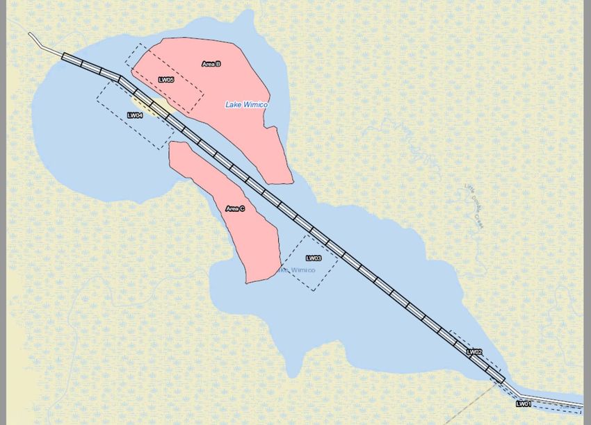
Draft Environmental Assessment & Section 404(b)(1) – Lake Wimico, Florida                                                         June 2021
Gulf Intracoastal Waterway

Table of Contents
LIST OF FIGURES ...................................................................................................................... 3
LIST OF TABLES ........................................................................................................................ 3
ABBREVIATIONS AND ACCRONYMS .................................................................................. 4
1.0      INTRODUCTION ............................................................................................................... 5
   1.1       Project Authority ......................................................................................................... 5
   1.2       Description of the Entire Authorized GIWW Project.......................................... 5
   1.3       Environmental Impact Assessment and Prior Studies History ...................... 6
   1.4       Project History of the GIWW .................................................................................... 6
2.0      PURPOSE AND NEED FOR THE PROPOSED ACTION ......................................... 7
3.0      DESCRIPTION OF THE PROPOSED ACTION .......................................................... 7
4.0      ALTERNATIVES TO THE PROPOSED ACTION ....................................................... 8
   4.1       No Action Alternative ................................................................................................. 8
5.0      PHYSICAL ENVIRONMENT........................................................................................... 8
   5.1 Climate ............................................................................................................................... 8
   5.2 Topography, Geology, and Soils................................................................................. 9
   5.3 Hydrodynamic Modeling ............................................................................................... 9
6.0      AFFECTED ENVIRONMENT.......................................................................................... 9
   6.1 Hydrology and Water Resources .............................................................................. 10
   6.2 Air Quality........................................................................................................................ 11
   6.3 Noise ................................................................................................................................. 11
   6.4 Water Quality .................................................................................................................. 11
   6.5 Sediment Quality ........................................................................................................... 12
   6.6 Environmental Resources .......................................................................................... 13
       6.6.1 Submerged Aquatic Vegetation ......................................................................... 13
       6.6.2 Wetlands ................................................................................................................... 14
       6.6.3 Terrestrial Wildlife.................................................................................................. 14
       6.6.4 Benthos, Motile Invertebrates, and Fishes ..................................................... 15
       6.6.5 Essential Fish Habitat ........................................................................................... 16
       6.6.6 Threatened and Endangered Species .............................................................. 18
   6.7 Social Economic Environment .................................................................................. 21
       6.7.1 Economic Activity .................................................................................................. 21

                                                                       1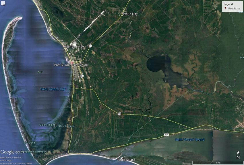
Draft Environmental Assessment & Section 404(b)(1) – Lake Wimico, Florida                                                         June 2021
Gulf Intracoastal Waterway

       6.7.2 Land Use................................................................................................................... 21
       6.7.3 Cultural Resources ................................................................................................ 22
   6.8 Recreation and Aesthetics.......................................................................................... 22
7.0 EFFECTED ENVIRONMENT ............................................................................................ 23
   7.1 Hydrology and Water Resources .............................................................................. 23
   7.2 Air Quality........................................................................................................................ 23
   7.3 Noise ................................................................................................................................. 24
   7.4 Water Quality .................................................................................................................. 24
   7.5 Sediment Quality ........................................................................................................... 24
   7.6 Environmental Resources .......................................................................................... 25
       7.6.1 Submerged Aquatic Vegetation ......................................................................... 25
       7.6.2 Wetlands ................................................................................................................... 25
       7.6.3 Terrestrial Wildlife.................................................................................................. 26
       7.6.4 Benthos, Motile Invertebrates, and Fishes ..................................................... 26
       7.6.5 Essential Fish Habitat ........................................................................................... 26
       7.6.6 Threatened and Endangered Species .............................................................. 27
   7.7 Social Economic Environment .................................................................................. 27
       7.7.1 Economic Activity .................................................................................................. 27
       7.7.2 Land Use................................................................................................................... 28
       7.7.3 Cultural Resources ................................................................................................ 28
   7.8 Recreation and Aesthetics.......................................................................................... 28
8.0 OTHER CONSIDERATIONS............................................................................................. 29
   8.1 Coastal Zone Management Act of 1972 ................................................................... 29
   8.2 Clean Water Act of 1972 .............................................................................................. 29
   8.3 River and Harbor Act 1899 .......................................................................................... 29
   8.4 Marine Mammal Protection Act of 1972, as amended ......................................... 29
   8.5 Executive Order (E.O.) 11988, Protection of Children ......................................... 29
   8.6 E.O. 11990, Environmental Justice ........................................................................... 29
9.0 REASONABLY FORSEEABLE ENVIRONMENTAL TRENDS AND PLANNED
ACTIONS..................................................................................................................................... 30
10.0 LIST OF AGENCIES, INTERESTED GROUPS AND PUBLIC CONSULTED ...... 30
11.0 LIST OF PREPARERS .................................................................................................... 31
12.0 REFERENCES .................................................................................................................. 32
APPENDIX A 404(b)(1) EVALUATION ................................................................................. 40

                                                                       2
Draft Environmental Assessment & Section 404(b)(1) – Lake Wimico, Florida                                        June 2021
Gulf Intracoastal Waterway

LIST OF FIGURES
Figure 1: Lake Wimico, Florida Federal Navigation Project Vicinity Map ................ 34
Figure 2: Lake Wimico, Florida............................................................................................. 35
Figure 3: Proposed Lake Wimico Open-Water Placement Areas ............................... 36
Figure 4: Sediment Sampling Locations in Lake Wimico ............................................. 37
Figure 5: Areas of SAV Surveys Conducted in 2017 ...................................................... 38
Figure 6: Lake Wimico National Wetlands Inventory Map ............................................ 39

LIST OF TABLES
Table 1: Fishery Management Plans and Managed Species for the .......................... 17
Table 2: Threatened and Endangered Species (USFWS 2019) .................................... 18

                                                              3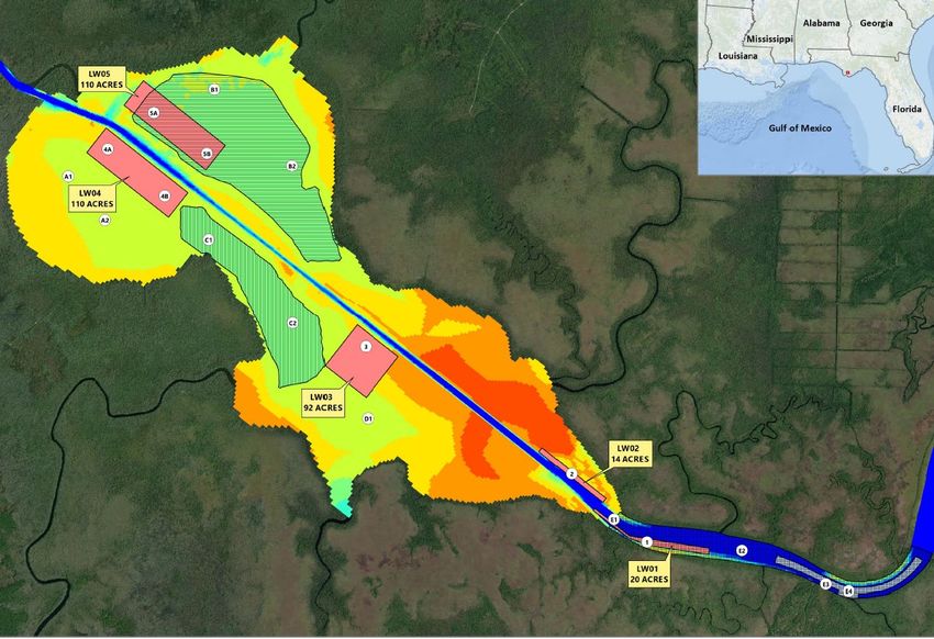
Draft Environmental Assessment & Section 404(b)(1) – Lake Wimico, Florida   June 2021
Gulf Intracoastal Waterway

ABBREVIATIONS AND ACCRONYMS
Apalachicola Chattahoochee Flint (ACF)
Area of Potential Effect (APE)
Bald and Golden Eagle Protection Act (BGEPA)
Clean Water Act (CWA)
Coastal Zone Consistency (CZC)
Code of Federal Register (CFR)
Council of Environmental Quality (CEQ)
Cubic Yards (cys)
Endangered Species Act (ESA)
Engineer Research and Development Center (ERDC)
Engineer Regulation (ER)
Environmental Assessment (EA)
Environmental Impact Statement (EIS)
Environmental Protection Agency (EPA)
Essential Fish Habitat (EFH)
Executive Order (EO)
Fahrenheit (F)
Finding of No Significant Impact (FONSI)
Florida Department of Environmental Protection (FDEP)
Gulf Intracoastal Waterway (GIWW)
Inland Testing Manual (ITM)
Mean Lower Low Water (MLLW)
Mean Sea Level (MSL)
National Ambient Air Quality Standards (NAAQS)
National Environmental Policy Act (NEPA)
National Historic Preservation Act (NHPA)
National Marine Fisheries Service (NMFS)
National Marine Fisheries Service-Protected Resources Division (NMFS-PRD)
Parts per thousand (ppt)
Polycyclic Aromatic Hydrocarbons (PAH)
Probable Effect Concentrations (PEC)
Sediment Quality Guidelines (SQGs)
State Historic Preservation Officer (SHPO)
Submerged Aquatic Vegetation (SAV)
Threshold Effect Concentrations (TEC)
Total Kjeldahl Nitrogen (TKN)
Total Maximum Daily Loads (TMDL)
Total Organic Carbon (TOC)
Total Petroleum Hydrocarbons (TPH)
Tribal Historic Preservation Officer (THPO)
U.S. Army Corps of Engineers (USACE)
U.S. Fish and Wildlife Service (USFWS)
U.S. Geological Survey (USGS)

                                                 4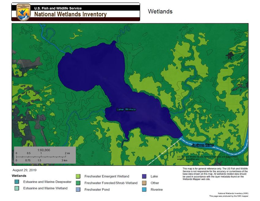
Draft Environmental Assessment & Section 404(b)(1) – Lake Wimico, Florida       June 2021
Gulf Intracoastal Waterway

1.0 INTRODUCTION
The purpose of this Environmental Assessment (EA) is to address impacts of dredged
material placement activities using newly proposed open-water placement areas within
Lake Wimico as part of the federally authorized Gulf Intracoastal Waterway (GIWW) in
Florida. Lake Wimico is located near Port St. Joe in Gulf County, Florida (Figures 1 &
2). The GIWW bisects the lake between river miles 335 and 341. Lake Wimico is
approximately 4,000 acres and is situated to the west of the lower Apalachicola River, to
the east of White City, and to the north of Port St. Joe at 29° 48’03”N 85° 08’52”W.

The National Environmental Policy Act (NEPA) of 1969, as amended, excuses or
excludes Federal agencies from the preparation of any formal environmental analysis
with respect to actions that result in minor or no environmental effects, known as
"categorical exclusions.” An intermediate level of analysis, an EA, is prepared for an
action that is not categorically excluded but does not clearly require an Environmental
Impact Statement (EIS) [40 Code of Federal Register (CFR) §1501.3 (a) and (b)].
Based on the EA, a Federal agency either prepares an EIS, if one appears warranted,
or issues a "Finding of No Significant Impact" (FONSI), which satisfies the NEPA
requirement. This EA is prepared according to the U.S. Army Corps of Engineers
(USACE) Engineer Regulation (ER) 200-2-2, Procedures for Implementing NEPA, and
the Council of Environmental Quality (CEQ) Regulations (40 CFR § 1508.27) for
Implementing the Procedural Provisions of NEPA (40 CFR § 1500-1508). The CEQ
published its Final Rule: Update to the Regulations Implementing the Procedural
Provisions of the National Environmental Policy Act (NEPA) in the Federal Register July
16, 2020. The new CEQ NEPA Regulations went into effect September 14, 2020. As
such, this EA has been prepared in accordance with the NEPA and the CEQ regulation
updates from 2020.

1.1    Project Authority

The existing GIWW project was authorized by the 1936 River and Harbor Act (also
known as the Flood Control Act of 1936), Pub. L. 74–738, as amended.

1.2    Description of the Entire Authorized GIWW Project

The authorized project provides for a waterway 12 feet deep and 125 feet wide from
Apalachee Bay, Florida, to Mobile Bay, Alabama and a 12 feet deep and 150 feet wide
from Mobile Bay, Alabama, to the Rigolets, Louisiana (Lake Borgne Light No. 29), and
for a tributary channel (the Gulf County Canal), 12 feet deep, 125 feet wide, and about 6
miles long connecting the waterway at White City, Florida with St. Joseph Bay. The
waterway between the 12-foot contours in Apalachee Bay and Lake Borgne Light No.
29 at the Rigolets is 379 miles long.

The existing GIWW project was authorized by the 1936 River and Harbor Act (also
known as the Flood Control Act of 1936), Pub. L. 74–738, as amended.

                                                 5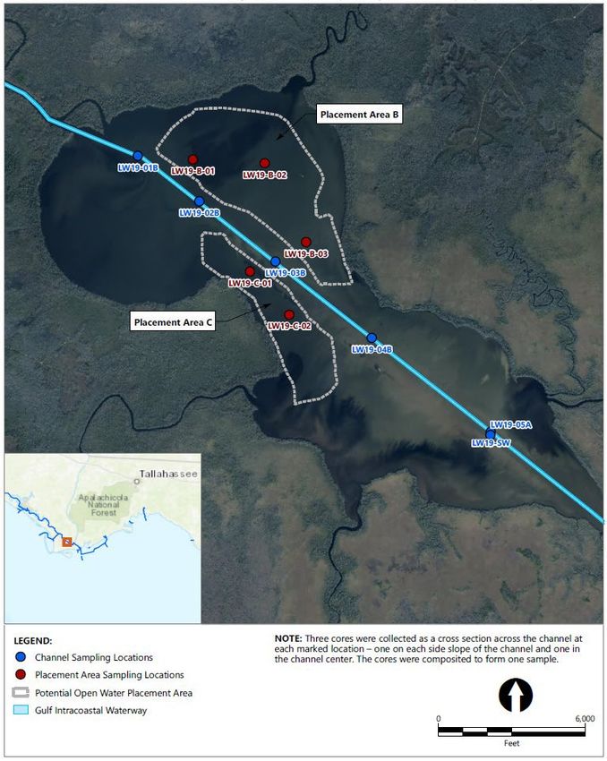
Draft Environmental Assessment & Section 404(b)(1) – Lake Wimico, Florida      June 2021
Gulf Intracoastal Waterway

1.3    Environmental Impact Assessment and Prior Studies History

An EIS was prepared for maintenance dredging activities for the portion of the waterway
within the Mobile District. This portion starts from Lake Borgne (GIWW Mile 36.3) and
ends at its intersection with Carrabelle Harbor Channel (GIWW Mile 376.3), including
the Gulf County Canal. An 1976 EIS entitled, Environmental Statement for
Maintenance Dredging of the Gulf Intracoastal Waterway from Pearl River, Louisiana-
Mississippi to Apalachee Bay, Florida, U.S. Army Corps of Engineers, (USACE), Mobile
District, was prepared to address the impacts associated with the maintenance dredging
of the GIWW. In 1984, an EA entitled, Environmental Assessment for Modifications to
the Maintenance Plan as Presented in the Final Environmental Statement Maintenance
Dredging of the Gulf Intracoastal Waterway from Pearl River, Louisiana-Mississippi to
Apalachee Bay, Florida (USACE, 1984), was prepared to address changes to the
existing maintenance plan presented in the 1976 EIS. Changes to the plan addressed
in the 1984 EA consisted of following: adjustments in the average timing and frequency
of maintenance dredging; subdivision and renumbering of disposal areas; the addition
of 14 disposal areas; size modifications to 11 upland and eight open water disposal
areas; and changes in estimates of dredging quantities. The 1984 EA resulted in a
FONSI, which was signed on February 7, 1984.

A prior EA was completed in 2014 that addressed environmental regulation updates to
the GIWW federally authorized navigation project for the Florida panhandle, and also
addressed impacts of dredging and previously authorized placement areas (with the
closest site for Lake Wimico material in the Gulf County Canal upland placement areas).
The FONSI was signed on May 9, 2014.

1.4    Project History of the GIWW

In 1909, Congress directed an investigation of a continuous waterway, "inland where
practicable," along the Gulf of Mexico from St. George Sound, Florida to the Mississippi
River and New Orleans. Several surveys between 1907 and 1925 resulted in the
construction of numerous disconnected reaches of channel along the coast, with
dimensions ranging from five feet by 40 feet to 12 feet by 90 feet.

The completion of the canal between Choctawhatchee Bay and St. Andrews Bay,
Florida, in 1938, made the continuous waterway from St. George Sound to New Orleans
a reality. In addition, the extension of the channel from Apalachicola through St.
George Sound and Carabelle and thence inland to St. Marks, Florida was authorized in
1937. The waterway, however, has only been completed as far as Carrabelle, Florida.
Barge traffic destined for St. Marks precedes from St. George Sound through the open
Gulf of Mexico, Apalachee Bay, and the St. Marks River.

                                                 6
Draft Environmental Assessment & Section 404(b)(1) – Lake Wimico, Florida June 2021
Gulf Intracoastal Waterway
The history of Lake Wimico is tied directly to the GIWW as the channel bisects the lake
for approximately six miles and, until recently (2019), has not been dredged since the
mid 1990’s. The most recent mechanical dredging event removed approximately
350,000 cubic yards (cys) and the material was barged to upland placement areas
along the Gulf County canal. The impacts from Hurricane Michael that made landfall in
the nearby coastal communities of the Florida panhandle on October 10, 2018 caused
the need for maintenance dredging, and placement options, within the lake. In the past,
dredged material would either be side cast adjacent to the channel or barged long
distances to access upland placement alternatives. The currently proposed action
would facilitate placement of maintenance dredged material within the lake in deeper
segments allowing for lake sediments to remain within the natural lake community and
decreases overall cost of placement alternatives.
2.0 PURPOSE AND NEED FOR THE PROPOSED ACTION
The USACE is responsible for providing the federally authorized navigation channel in
Lake Wimico that allows for navigation use along the GIWW. Adequate placement
capacity is necessary to maintain sufficient channel depths and widths. To ensure this
channel is maintained, additional placement sites were pursued to ensure disposal
capacity.
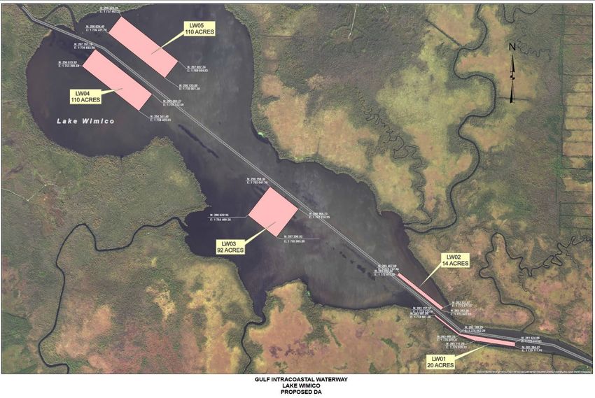
3.0 DESCRIPTION OF THE PROPOSED ACTION
The proposed action consists of adding two new open-water placement sites to
accommodate approximately 250,000 cys of maintenance dredged material removed
from the Lake Wimico portion of the GIWW typically between stations 15785+00 and
16000+00 (dependent on shoaling needs). Dredging and placement activities would be
accomplished using hydraulic (cutterhead) or mechanical dredging equipment. The
material would be placed in those two newly proposed open-water placement areas
within Lake Wimico adjacent to the channel (Figure 3). The GIWW Federal navigation
project is maintained to a -12-foot MLLW and 125-foot wide channel. For all channel
segments, an additional -2 feet of advance maintenance dredging and -2 feet of
overdepth dredging are included to maintain the channel. Maintenance dredging of
soft-dredged material with mechanical, and/or hydraulic cutterhead dredges tends to
disturb the bottom sediments several feet deeper than the target depth due to the
inaccuracies of the dredging process. An additional -3 feet of sediment below the -2-
foot paid allowable dredging cut may be disturbed in the dredging process with minor
amounts of the material being removed (Tavolaro et al., 2007).
Two large areas are proposed for dredged material placement in Lake Wimico (Figure
3). One area (LW-B, approximately 611 acres) is located on the northern side of the
channel in the northwest corner of the Lake. A second area (LW-C, approximately 291
acres) is located on the southern side of the channel near the midpoint of the lake.
7Draft Environmental Assessment & Section 404(b)(1) – Lake Wimico, Florida June 2021
Gulf Intracoastal Waterway
Average water depths in both placement areas (LW-B and LW-C) range between 5.5
and 6 feet MLLW. The placement areas are in two deeper portions of the lake. The
shape of LW-B mimics the northwestern lobe of Lake Wimico, and LW-C as an
elongated placement area that lies between the channel and the south-central shoreline
of the lake. Sediments in the placement areas are similar (physically and chemically) to
that of maintenance dredged material from the channel.
4.0 ALTERNATIVES TO THE PROPOSED ACTION
4.1 No Action Alternative
The NEPA defines a “no action” as the continuation of existing conditions in the affected
environment without the implementation, or in the absence of the proposed action.
Inclusion of the “no action” alternative is prescribed by CEQ regulations as the
benchmark against which Federal actions are to be evaluated. The implementation of
the "no action" alternative would result in continued shoaling and restrictive passage
through Lake Wimico by both commercial, private, and recreational vessels. This
alternative would not provide the necessary conditions for safe movement of commerce
or marine vessels through the lake. The “no action” alternative would also precipitate
the need for transport of dredged material approximately 10 miles down the Gulf County
Canal for placement in previously authorized upland placement areas at a greater
expense than the proposed action. Therefore, the "no action" plan was deemed a non-
feasible alternative. The only other considered alternative is the proposed action as
described in Section 3.0 of this EA.
5.0 PHYSICAL ENVIRONMENT
5.1 Climate
The climate of the Gulf County, Florida is typical of that experienced along the northern
Gulf Coast. The range in both temperature and humidity extremes is small because of
the moderating effects of the Gulf. These ranges decrease even more when southerly
winds prevail and impart characteristics of a marine climate. Continental influences are
felt with northerly winds that usually bring relatively dry air and larger diurnal
temperature ranges. The annual average precipitation for the central portion of Gulf
County, Florida Panhandle is greater than 58 inches. Frequency of rainfall is consistent
through most of the year. Afternoon thunderstorms increase the amount of rainfall
during the summer. Hurricanes can also contribute significantly to rainfall accumulation
from summer to early fall.
The average annual maximum daily temperature is approximately 78° Fahrenheit (F).
Average annual minimum daily temperature falls around 59° F. Temperatures in the
area range greater than 88° F within the summer months of July and August to lows of
8Draft Environmental Assessment & Section 404(b)(1) – Lake Wimico, Florida June 2021
Gulf Intracoastal Waterway
40° F in January. Summer and early fall humidity is high, usually between 80 and 100
percent in the afternoon. Winter and early spring humidity is much lower, often less
than 20 to 40 percent during the warmest time of day.
5.2 Topography, Geology, and Soils
Gulf County, Florida covers an area of approximately 592 square miles and is
comprised of a relatively flat terrain, ranging in elevation from 0 to approximately 50 feet
above mean sea level (MSL). Lake Wimico lies in the Gulf coastal lowlands
physiographic province, and is characterized overall by numerous small creek
drainages, alluvial rivers, inland lakes, bays and sounds. According to data gathered by
the Shuttle Radar Topography Mission, the lowest elevation in Gulf County is -46 feet
ranking Gulf County 44th in terms of lowest elevations when compared to a total of 67
counties in Florida. Gulf County's highest elevation is 148 feet which ranks it 36th in
terms of highest elevations when compared to a total of 67 counties in Florida.
Soils in Gulf County, Florida surrounding Lake Wimico consist predominately of medium
to fine grain sands and silts associated with recent Pleistocene formations (USGS,
1982). Specifically, lower marine and estuarine deposits are prevalent from
accumulated deposition from the Gulf of Mexico. The stratigraphy generally includes
light sandy moderately well-drained topsoils overlaying dark somewhat poorly drained
sandy subsoil. The wetland soils tend to have a higher clay content, but the marine
origins of the predominate parent materials tend to make sand the dominate grain size
throughout. Sediments in Lake Wimico are characterized predominantly by silts and
clays (65-90%) and sands (10-35%) (USACE and Anchor QEA, 2020).
5.3 Hydrodynamic Modeling
In 2019, the USACE via its contractor, conducted hydrodynamic modeling in Lake
Wimico to express sediment deposition and potential placement areas within the lake.
Most of the shoaling in the channel is focused along the center reach of the channel.
Additionally, the modeling showed two large potential placement areas in the
northwestern portion of the lake (Figure 3) that were deep areas, and not near to
surrounding submerged aquatic vegetation (SAV) beds along shorelines and in
shallower portions of the lake. Overall, the channel is deeper on both ends of the lake
with higher rates of shoaling in the center portion caused by tropical storm activity since
2018.
6.0 AFFECTED ENVIRONMENT
The safeguarding of Lake Wimico helps preserve and protect the water quality of the
highly productive Apalachicola River, Apalachicola Bay and Gulf of Mexico. It creates a
protected refuge for resident and migratory wildlife, including many federally and state
9Draft Environmental Assessment & Section 404(b)(1) – Lake Wimico, Florida June 2021
Gulf Intracoastal Waterway
listed species. The lake and its surrounding lands and waters are home to the Florida
black bear, manatee, bald eagle, osprey, and many species of wading and shore birds,
and turtles. Its water flow into Apalachicola Bay is critical to nurseries of migrating fish
and oyster populations. Additionally, the conservation of the cypress-dominated
swamps, marshes and water flow help ensure a resilient landscape that provides
adaptation to impacts of climate change and sea level rise, and habitat for ecological
communities.
6.1 Hydrology and Water Resources
The Lake Wimico watershed drains approximately 75,000 acres from surrounding Gulf
County, Florida environments with an abundant supply of both surface and groundwater
inputs. Lake Wiimico is located in the extreme southeastern portion of Gulf County with
flow coming from the west in St. Andrew’s Bay and flow exiting the lake into
Apalachicola River and Bay to the east. Lake Wimico also falls between two major
groundwater systems located in the general vicinity: the Sand and Gravel Aquifer
located in the western portion of the panhandle and the Florida Aquifer System in the
east. Hydrology from Lake Wimico flows to increasingly saline environments in St.
Andrew Bay, Apalachicola Bay, and St. Joseph Bay (Brim and Handley, 2007). U.S.
Geological Survey (USGS) gage 02359170 (closest USGS gage to Lake Wimico) on the
Apalachicola River measures water quality parameters ranging from temperature,
dissolved oxygen, turbidity, pH, and specific conductance and provides data for
potential inputs to Lake Wimico.
The groundwater supply in and around Lake Wimico is abundant and generally of good
quality. This stems from two factors; a high annual rainfall and an aquifer of
unconsolidated quartz sand and gravel that serves as an immense reservoir. The
groundwater in this region supplies nearly 80 percent of the wells in the panhandle and
is one of the softest and least mineralized groundwater supplies within the state
(McGovern, 2007).
The St. Andrew Bay watershed covers approximately 750,000 acres in Walton,
Washington, Jackson, Calhoun, Gulf and Bay counties. It is the only major basin that
lies entirely within the Florida panhandle. The average depth of the bay is 27 feet.
Several embayments are included in the watershed; these are the St. Joseph Bay and
the interconnected St. Andrew, West, East and North bays.
The Apalachicola River and Bay Basin encompasses approximately 280 square miles
and incorporates St. Vincent Sound, East Bay, Apalachicola Bay, and St. George
Sound. The watershed is part of a larger basin, the Apalachicola-Chattahoochee-Flint
(ACF) River system. The ACF river basin covers the southeastern part of Alabama,
north-central and southwestern portions of Georgia, as well as the central part of the
Florida panhandle. The major freshwater inflow to the bay is from the Apalachicola
River. Headwaters for this alluvial river system originate in the Blue Ridge
physiographic province (Livingston et al., 1974).
10Draft Environmental Assessment & Section 404(b)(1) – Lake Wimico, Florida June 2021
Gulf Intracoastal Waterway
6.2 Air Quality
The Clean Air Act of 1970, as amended, mandated that the U. S. Environmental
Protection Agency (EPA) establish ambient standards for certain pollutants, regarding
all identifiable effects a pollutant may have on the public health and welfare. The EPA
subsequently developed the National Ambient Air Quality Standards (NAAQS)
identifying levels of air quality, which it judged necessary to protect public health and
welfare, and account for the environment. Areas in compliance with the NAAQS are
termed as in attainment areas, while areas not meeting the standards are termed non-
attainment areas. The Florida Department of Environmental Protection (FDEP)-Division
of Air Resource is responsible for administrating the Clean Air Act in the State of
Florida.
According to the monitored ambient air quality measurements, Gulf County is
considered an attainment area for all monitored pollutants including Carbon Monoxide
(CO), Ozone (O3), Particulate Matter (PM-10), Sulfur Dioxide (SO2), and Lead (Pb).
Sources of air pollution in the project area are minor and mainly due to non-point
sources, such as boat motors and commercial vessel emissions. No major sources of
air pollution were found within the vicinity of the project area.
6.3 Noise
Noise, generally, can be defined as unwanted sound and, therefore, is considered a
relative environmental parameter. Noise levels in the area are primarily from
commercial and recreational vessels. Noise levels fluctuate with highest levels usually
occurring during the spring and summer months due to increased boating and
commercial vessel activities.
6.4 Water Quality
The Clean Water Act (CWA) is the primary federal law in the United States governing
water pollution. Its objective is to restore and maintain the chemical, physical, and
biological integrity of the nation's waters; recognizing the responsibilities of the states in
addressing pollution and providing assistance to states to do so, including funding for
publicly owned treatment works for the improvement of wastewater treatment; and
maintaining the integrity of wetlands.
Water quality within Lake Wimico is tidally influenced from the west in St. Andrew Bay
and other factors including freshwater discharges from rivers, such as the Apalachicola
River, and creeks and seasonal climate changes (Brim and Handley, 2007) (Livingston,
1984). Freshwater inputs from local watersheds provide nutrients and sediments that
serve to maintain productivity both in the lake and in the extensive marsh, swamp, and
forested habitats Lake Wimico. Marsh habitats act to regulate the discharge of nutrients
11Draft Environmental Assessment & Section 404(b)(1) – Lake Wimico, Florida June 2021
Gulf Intracoastal Waterway
to coastal waters and serve as a sink for pollutants.
The FDEP has classified the waters in Lake Wimico as suitable for recreation,
propagation of fish and wildlife and shellfish harvesting (Class III). Sufficient dissolved
oxygen concentrations, water clarity, and typical salinity ranges with little to no
stratification in the water column occur within the lake. Water quality within Lake
Wimico is influenced mainly by non-point source pollution. According to the 2018 Final
Integrated Water Quality Assessment for Florida Section 303(d) list prepared by FDEP,
Lake Wimico falls into a category of insufficient data to determine if any designated use
is attained. The 2018 303(d) Impaired Waters and Total Maximum Daily Loads (TMDL)
found the State of Florida’s surface and groundwater resources were predominantly in
good condition based on the indicators assessed. In addition, water quality in the
northwest sections of the state (where Lake Wimico is located) was generally better
compared to other areas of the state.
6.5 Sediment Quality
An evaluation of dredged material within the Lake Wimico GIWW channel was
performed by the USACE through its contractor in October 2019. Sediments proposed
for removal and placement were sampled (Figure 4), analyzed, and evaluated for
suitability of placement in adjacent open water areas. Sediment analyses followed
guidelines in both the USACE/EPA Inland Testing Manual (ITM) and the State of Florida
Submerged Lands and Environmental Resources Permitting Program (SLERP). Field
sampling consisted of sediment and water sample collection for physical and chemical
analysis. Chemical analyses included total organic carbon (TOC), ammonia, nitrate,
nitrite, total Kjeldahl nitrogen (TKN), phosphorus, metals, polycyclic aromatic
hydrocarbons (PAHs), and total petroleum hydrocarbons (TPH). Standard elutriates
were created from each sampling location composite and analyzed for metals at FDEP
request.
Nutrients (ammonia as nitrogen, nitrate plus nitrite, TKN, and phosphorus) were
detected in all bulk sediment samples. Nutrient concentrations were generally
consistent between the Lake Wimico GIWW samples, with slightly higher concentrations
in the locations located toward the middle of Lake Wimico (LW19-03 and LW19-04)
(Figure 4). All 11 metals were detected in low concentrations in all Lake Wimico GIWW
and placement area samples. Generally, the concentrations of metals in the Lake
Wimico placement area samples were slightly greater than the metals concentrations
reported in the Lake Wimico GIWW samples. At least one PAH was detected in all
Lake Wimico GIWW and placement area samples. The Lake Wimico placement area
samples generally had a higher frequency of detection of individual PAHs and slightly
greater concentrations than the Lake Wimico GIWW samples. TPH was detected in all
Lake Wimico GIWW samples, apart from LW19-05, and in three of the five placement
area samples (LW19-B-03, LW19-C-01, and LW19-C-02). Concentrations of detected
analytes in sediment samples were compared to sediment quality guidelines (SQGs) for
freshwater sediments to assess the sediment quality of the material proposed for
dredging. The SQGs used for comparison are the threshold effect concentrations
12Draft Environmental Assessment & Section 404(b)(1) – Lake Wimico, Florida June 2021
Gulf Intracoastal Waterway
(TECs) and probable effect concentrations (PECs). The TEC values represent the
concentrations below which adverse biological effects are unlikely, and PEC values
represent concentrations above which adverse biological effects are probable
(MacDonald et al. 2000). All detected analytes were less than their respective TECs or
PECs in all samples and in many instances were substantially less than their respective
TECs.
Surface water sample results detected ammonia and nitrate plus nitrite below the
Florida Freshwater Criteria. Seven metals were detected in low concentrations in the
surface water sample, each of which was substantially less than both the EPA and
State of Florida water quality criteria. PAHs and TPH were not detected in the site water
sample. Seven metals were detected in low concentrations in the standard elutriate
samples. However, the concentrations of each of the detected metals were substantially
less than both the EPA and State of Florida water quality criteria (Table 4). For mercury,
samples were run using the standard method (not the low level method) because of the
preservation used by the analytical laboratory after elutriates were generated, which
resulted in a detection limit (0.1 micrograms per liter [μg/L]) above the State of Florida
water quality criteria (0.012 μg/L). Mercury was only detected in two of the elutriate
samples, both at concentrations well below the EPA acute and chronic criteria (Anchor
QEA, 2020).
Overall, sediments dredged from Lake Wimico, and the proposed open-water
placement areas do not exceed federal and state water quality standards and do not
pose an increased effect for contamination within Lake Wimico and the surrounding
environment.
6.6 Environmental Resources
6.6.1 Submerged Aquatic Vegetation
A recent study of SAV from 2017 was conducted by the USACE, Engineer Research
and Development Center (ERDC) on behalf of the USACE, Mobile District to access
location, species, and percent cover within previously proposed placement areas
adjacent to the channel in Lake Wimico (Figure 4). Results of the survey showed one
dominant SAV species within the survey areas, Vallisneria americana (American
eelgrass). V. americana is a submersed native grass found in many Florida lakes
typically growing in clearer bodies of water. Lake Wimico is mostly calm and turbid with
a relatively fast-moving channel (2-3 knots). V. americana was found in waters of 2
meters or less and only three of the five surveyed placement areas (LW04, LW03 and
LW02) (Figure 5) showed significant data. In most locations this limited the distribution
of the plant to the very shallow areas and close to the banks. Approximately 92+% of all
areas surveyed in Lake Wimico exhibited no vegetation. LW04 lies along the
northwestern shore and just downstream from the inlet from White City and southwest
of the channel. LW03 showed a shallow bar farther downstream and closer to the
middle of the lake. These results shaped the areas proposed for placement within Lake
13Draft Environmental Assessment & Section 404(b)(1) – Lake Wimico, Florida June 2021
Gulf Intracoastal Waterway
Wimico as areas surrounding LW05, LW04, and LW03 were chosen for possible
placement due to depths and relative absence of SAV colonization.
6.6.2 Wetlands
Lake Wimico is a wholly underdeveloped section of the panhandle of Florida. Lake
Wimico is surrounded by expansive forested and emergent wetlands (Figure 6) as
reported by the U.S. Fish and Wildlife Service’s (USFWS) National Wetlands Inventory.
No wetlands are located within the federal channel of Lake Wimico nor in the proposed
open-water placement areas. At the narrowest part of the lake, the nearest emergent
forested wetlands are approximately 1,000 meters away from the federal navigation
channel in Lake Wimico. At the widest part of the lake emergent forested wetlands are
approximately 2,000 to 2,500 meters away from the channel.
Local freshwater forested/shrub wetland habitats are characterized by non-tidal
wetlands dominated by trees, shrubs, persistent emergents, emergent mosses or
lichens. It also includes wetlands lacking such vegetation, but with all of the following
four characteristics: (1) area less than 8 hectares (20 acres); (2) active wave-formed or
bedrock shoreline features lacking; (3) water depth in the deepest part of the basin less
than 2.5 meters (8.2 feet) at low water; and (4) salinity due to ocean-derived salts less
than 0.5 parts per thousand (ppt). During the 2019 sediment analysis study conducted
in Lake Wimico, salinity values ranged from 2-4 ppt (Anchor QEA, 2020). These
habitats also exhibit woody vegetation that is 6 meters tall, or taller, and angiosperms
(trees or shrubs) with relatively wide, flat leaves that are shed during the cold or dry
season; e.g., black ash (Fraxinus nigra). Tidal fresh surface water is present for
extended periods (generally for more than a month) during the growing season but is
absent by the end of the season in most years. When surface water is absent, the
depth to substrate saturation may vary considerably among sites and among years.
Tidal fresh surface water persists throughout the growing season in most years. When
surface water is absent, the water table is usually at or very near the land surface.
Freshwater emergent wetlands in the area are characterized by erect, rooted,
herbaceous hydrophytes, excluding mosses and lichens. This vegetation is present for
most of the growing season in most years. These wetlands are usually dominated by
perennial plants, and species that normally remain standing at least until the beginning
of the next growing season. Surface water persists throughout the growing season in
most years. When surface water is absent, the water table is usually at or very near the
land surface.
6.6.3 Terrestrial Wildlife
The terrestrial environment surrounding Lake Wimico is comprised of forested and
freshwater wetland habitats dominated by pine savannahs, hardwood stands, Cypress
communities, freshwater streams and marshes, and wet prairies. Characteristic plants
14Draft Environmental Assessment & Section 404(b)(1) – Lake Wimico, Florida June 2021
Gulf Intracoastal Waterway
include pond cypress (Taxodium ascendens), bald cypress (Taxodium distichum),
needlerush (Juncus roemerianus), sawgrass (Cladium jamaicense), cattails (Typha
spp.), giant reed (Phragmites communis), arrowhead (Sagittaria lancifolia), giant
cutgrass (Zizaniopsis miliancea), pickerel weed (Pontederia cordata), and softstem
bulrush (Scirpus validus) (NWF WMD, 1997).
Terrestrial wildlife that may be found surrounding Lake Wimico consists of a wide
variety of birds, mammals, reptiles and amphibians. Some of the highest diversity of
reptiles and amphibian groups in the U.S. exists within the region. The surrounding
drainage basins also provide some of the most important bird habitats, which receive
large numbers of migratory birds from both the Midwest and Atlantic Seaboard.
The adult bald eagle is a large dark brown bird with a white head and tail and yellow bill,
eyes, legs and feet. The female is larger than the male by as much as 25 percent. The
juvenile bald eagle is mostly dark brown with dark brown eyes and a gray or black bill,
but has white patches or spots on its tail, belly and under its wings. Plumage of
juveniles varies, generally losing the white on their bodies and becoming increasingly
white on their heads and tails as they gain maturity. Full adult plumage for bald eagles
typically appears in their fifth year.
In Florida, females typically lay a clutch of 1-3 eggs between December and early
January, with incubation lasting about 35 days. Most of Florida's breeding bald eagles,
especially those in the extreme southern peninsula, remain in the state year-round.
Sub-adult, non-breeding eagles migrate out of Florida starting in spring and summer
and returning in fall and winter.
Their nesting territories are concentrated around inland lake and river systems in
peninsular Florida, such as the Kissimmee Chain of Lakes, and along the Gulf coast.
Bald eagles use forested habitats for nesting and roosting, and expanses of shallow
fresh or salt water for foraging. Nesting habitat generally consists of mature canopy
trees located along habitat edges, providing an unobstructed view of surrounding
areas. Daytime roosts are in the highest trees and adjacent to shorelines. High quality
foraging habitat for bald eagles has a diversity and abundance of prey, access to
shallow water and tall trees or structures for perching. They feed on a wide variety of
prey, mostly on fish such as catfish but also on birds and small mammals. They may be
found nesting in the forested areas, and foraging in and around Lake Wimico.
6.6.4 Benthos, Motile Invertebrates, and Fishes
The estuaries and bays in the vicinity of Lake Wimico provide habitat for several
crustacean species, which include brown shrimp (Penaeus aztecus), pink shrimp (P.
Duorarum), white shrimp (P. setiferus), marsh grass shrimp (Palaemonetes pugio), and
common blue crab (Calinectes sapidus). These motile aquatic species travel from the
surrounding estuaries and bays to utilize Lake Wimico as refuge and potential feeding
grounds. While there, they may become prey items for individuals of a higher trophic
level. Important commercial and recreational fishes, which feed on these invertebrates
15Draft Environmental Assessment & Section 404(b)(1) – Lake Wimico, Florida June 2021
Gulf Intracoastal Waterway
or on aquatic primary producers, would include: striped mullet (Mugil cephalus), spotted
seatrout (Cynoscion nebulosus), sand seatrout (Cynoscion arenarius), red drum
(Sciaenops ocellata), black drum (Pogonias cromis), silver perch (Bairdiella chrysura),
Atlantic croaker (Micropogon undulates), spot (Leiostomus xanthurus), southern king
(Menticirrhus saxatilis), southern flounder (Paralichthys lethostigma), Gulf flounder
(Paralichthys albigutta), Gulf menhaden (Brevoortia patronus), striped mullet (Mugil
cephalus), Florida pomano (Trachinotus carolinus), and Spanish mackerel
(Scomberomorus maculates). The freshwater lakes and rivers located throughout the
project area include species such as white and channel catfish (Ictalurus punctatus),
yellow bullheads (Ictalurus natalis), largemouth bass (Micropterus salmoides),
numerous sunfish and pickerel. The migratory Alabama shad and skipjack herring can
also be expected throughout various reaches surrounding the project area.
Microinvertebrate populations are dictated by substrate type, temperature, salinity and
biological factors, they therefore vary significantly throughout the vicinity of the project.
Studies in the East Bay-Apalachicola Bay and others in the Choctawhatchee complex
indicate that predominate species in the spring months tend to be Mediomastus
ambiseta, Heteromastus filiformis, Ampelisca vadorum, Hargeria rapax, and
Grandidierella bonnieroids. In the summer and fall months, Steblospio benedicti and
Hypaneola florida tend to dominate. It is important to note that all listed species, as well
as less prevalent species, are present year-round in various numbers as these species
are non-motile in nature (Saloman et al., 1982).
Marine shrimp are by far the most popular seafood in the United States, however, only
those of the family Penaeidae are large enough to be considered seafood. Brown
shrimp (Penaeus aztecus), white shrimp (P. setiferus) and pink shrimp (P. duorarum)
make up the bulk shrimp landings in and around Lake Wimico. The life cycles of brown,
white and pink shrimp are similar. They spend part of their life in estuaries, bays and
the Gulf of Mexico with spawning occurring in the Gulf of Mexico. One female shrimp
release 100,000 to 1,000,000 eggs that hatch within 24 hours. The post-larval shrimp
develop through several stages as they are carried shoreward by winds and currents.
Post-larvae drift or migrate to nursery areas within shallow bays, tidal creeks, and
marshes where food and protection necessary for growth and survival are available.
There they acquire color and become bottom dwellers. If conditions are favorable in
nursery areas, the young shrimp grow rapidly and soon move to the deeper waters.
When shrimp reach juvenile and sub-adult stages (3-5 inches long), they usually
migrate from the bays to the Gulf of Mexico where they mature and complete their life
cycles. Most shrimp will spend the rest of their life in the Gulf. Several shrimpers
actively fish in the vicinity of Apalachicola Bay and Lake Wimico.
6.6.5 Essential Fish Habitat
Essential Fish Habitat (EFH) is defined in the Magnuson-Stevens Fishery Conservation
and Management Act as "those waters and substrates necessary to fish for spawning,
breeding, feeding or growth to maturity”. The designation and conservation of EFH
seeks to minimize adverse effects on habitat caused by fishing and non-fishing
16Draft Environmental Assessment & Section 404(b)(1) – Lake Wimico, Florida June 2021
Gulf Intracoastal Waterway
activities. The National Marine Fisheries Service (NMFS) has identified EFH habitats
for the Gulf of Mexico in its Fishery Management Plan Amendments. These habitats
include estuarine areas, such as estuarine emergent wetlands, mangrove wetlands,
seagrass beds, algal flats, mud, sand, shell, and rock substrates, and the estuarine
water column. Table 1 provides a list of the species that NMFS manages under the
federally implemented Fishery Management Plan. The project area consists of open
estuarine habitat of partially vegetated bottoms with sand and silt substrates, SAV, and
bordering forested emergent wetlands. Of the species managed, the following may
utilize the project area based on a query of the 2019 NMFS EFH mapper: brown shrimp
(Penaeus axtecus), pink shrimp (P. duorarum), white shrimp (P. setiferus), king
mackerel (Scomberomorus cavalla), Spanish mackerel (S. maculate), gray snapper
(Lutjanus griseus), lane snapper (L. synagris), cobia (Rachycentron canadum), and red
drum (Sciaenops ocellatus).
Species managed by the GMFMC are listed in Table 1 below.
Table 1: Fishery Management Plans and Managed Species for the
Gulf of Mexico (NMFS 2017)
17Draft Environmental Assessment & Section 404(b)(1) – Lake Wimico, Florida June 2021
Gulf Intracoastal Waterway
Shrimp Fishery Management Plan
brown shrimp – Farfantepenaeu aztecus Spiny Lobster Fishery Management Plan
pink shrimp - F. duorarum spiny lobster - Panulirus argus
royal red shrimp - Pleoticus robustus
Coral and Coral Reef Fishery Management Plan
white shrimp - Litopenaeus setiferus varied coral species and coral reef communities
comprised of several hundred species
Reef Fish Fishery Management Plan
almaco jack – Seriola rivoliana Coastal Migratory Pelagic Fishery Management Plan
banded rudderfish – S. zonata cobia - Rachycentron canadum
blackfin snapper - Lutjanus buccanella king mackerel – Scomberomorus cavalla
Spanish mackerel - S. maculatus
black grouper- Mycteroperca bonaci
blueline tilefish – C. microps Red Drum Fishery Management Plan
cubera snapper – L. cyanopterus red drum - Sciaenops ocellatus
gag grouper - M. microlepis
goldface tilefish – C. chrysops
goliath grouper - Epinephelus itajara
gray snapper – L. griseus
gray triggerfish - Balistes capriscus
greater amberjack – S. dumerili
hogfish - Lachnolaimus maximus
lane snapper - Lutjanus synagris
lesser amberjack - S. fasciata
mutton snapper – L. analis
queen snapper - Etelis oculatus
red grouper – E. morio
red snapper - L. campechanus
scamp grouper - M. phenax
silk snapper – L. vivanus
snowy grouper – E. niveatus
speckled hind - E. drummondhayi
tilefish - Lopholatilus chamaeleonticeps
vermilion snapper - Rhomboplites aurorubens
Warsaw grouper – E. nigritus
wenchman - Pristipomoides aquilonaris
yellowedge grouper E .lavolimbatus
yellowfin grouper – M. venenosa
yellowmouth grouper – M. interstitialis
yellowtail snapper – Ocyurus chrysurus
6.6.6 Threatened and Endangered Species
Several species of threatened and endangered marine mammals, turtles, fish and birds
occur in Gulf County. The USFWS list the following species in Table 2 as either
threatened and/or endangered that may potentially occur within Gulf County.
Table 2: Threatened and Endangered Species (USFWS 2019)
LISTED SPECIES SCIENTIFIC NAME STATUS DATE LISTED
Mammals
West Indian manatee Trichechus manatus Endangered 03/11/67
18Draft Environmental Assessment & Section 404(b)(1) – Lake Wimico, Florida June 2021
Gulf Intracoastal Waterway
Reptiles
Eastern Indigo Snake Drymarchon corais coupen Threatened 03/03/78
Fish
Gulf sturgeon Acipenser oxyrinchus Threatened 09/30/91
Birds
Wood stork Mycteria americana Threatened 02/28/84
Piping Plover Charadrius melodus Threatened 12/11/85
Red knot Calidris canutus rufa Threatened 01/12/15
Red-cockaded Picoides borealis Endangered 10/13/70
woodpecker
Amphibians
Reticulated flatwoods Ambystoma bishopi Endangered 02/10/09
salamander
Flowering plants
White birds-in-a-nest Macbridea alba Threatened 05/08/92
Chapman Rhododendron chapmanii Endangered 05/23/79
rhododendron
Telephus spurge Euphorbia telephioides Threatened 05/08/92
Godfrey’s butterwort Pinguicula ionantha Threatened 07/12/93
Florida skullcap Scutellaria floridana Threatened 05/08/92
Note: Bald eagle (Haliaeetus leucocephalus) was delisted in 2007 from the Endangered Species Act
(ESA) and is now protected under the Bald and Golden Eagle Protection Act (BGEPA).
The federally listed species that may be found within the vicinity of the project area
include; West Indian manatee (Trichechus manatus), Eastern Indigo Snake
(Drymarchon corais coupen), Gulf sturgeon (Acipenser oxyrinchus), Wood stork
(Mycteria americana), Bald eagle (Haliaeetus leucocephalus) covered under the
(BGEPA), and Reticulated flatwoods salamander (Ambystoma bishopi).
The reticulated flatwoods salamander inhabits slash and longleaf pine flatwoods that
have a wiregrass floor and scattered wetlands (Florida Natural Areas Inventory
2001). This species occurs in Florida counties west of the Apalachicola River (Map
Data from: Thompson et al. 2014). Due to the nature of the proposed action (open
water placement activities) and habitat requirements for reticulated flatwoods
salamanders, this species will not be considered further in this EA.
West Indian manatee occur in coastal areas from the southeastern U.S. to northeastern
South America. It is found in rivers, estuaries, and coastal areas of subtropical and
tropical areas of northern South America, West Indies/Caribbean region, Gulf of Mexico
(now mainly western and southwestern portions) and southeastern North America. U.S.
populations occur primarily in Florida where they are effectively isolated from other
populations by the cooler waters of the northern Gulf of Mexico and the deeper waters of
the Straits of Florida (Domning and Hayek 1986). Occasionally manatees are found in
summer from Texas to North Carolina. The species occurs along most of the Gulf coast
19Draft Environmental Assessment & Section 404(b)(1) – Lake Wimico, Florida June 2021
Gulf Intracoastal Waterway
of Florida, but infrequently occurs north of the Suwannee River and between the
Chassahowitzka River and Tampa Bay. They also occur all along the Atlantic coast of
Florida, from the Georgia coast to Biscayne Bay and the Florida Keys, including the St.
Johns River, the Indian River lagoon system, and various other waterways (O'Shea and
Ludlow 1992). The species is primarily dependent upon submerged, emergent, and
floating vegetation. Their diet varies according to plant availability, and they may
opportunistically eat other foods. West Indian manatees could be found in Lake Wimico.
The Gulf sturgeon, also known as the Gulf of Mexico sturgeon, is one of seven species
of sturgeon found in North America. Sturgeons are prehistoric species that date back to
the time of dinosaurs. Sturgeons are popular in the food industry as a source of
caviar. They have physical features that separate them from other kinds of fish, such as
a spiral valve stomach and cartilaginous skeleton (like sharks and rays); however, they
have scutes (hard, protective, large individual body plates) instead of shark’s denticles
or bony-fish’s scales. Gulf sturgeon have barbels located on the underside of the snout,
no teeth, rubbery lips, and a suctorial mouth for vacuuming food off the bottom. The
sturgeon's coloring typically is dark brown along the upper (dorsal) side shading to a
creamy white-colored belly (Wakeford 2001). Gulf sturgeon are large fish that can
exceed a length of eight feet (2.4 meters), a weight of over 300 pounds (137 kilograms)
and can possess strength to leap nine feet (2.7 meters) into the air. The Gulf sturgeon
grow to greater than six feet in length, sports bony plates on its head and body, has
fleshy "whiskers" on its long snout, and has no internal skeleton. This ancient fish
evolved from much larger ancestors that lived more than 225 million years ago. Gulf
sturgeon may live for more than 40 years, not reaching sexual maturity until seven or
eight years of age or later.
Sturgeon are anadromous, a term used to describe fish that spend a part of their lives in
saltwater yet travel upstream in freshwater rivers to spawn. Such fish return year after
year to the same stream where they were hatched. For Gulf sturgeon, which are found
from Florida to Louisiana, this means a move from salt to fresh water between February
and April and a move downriver between September and November. They spend the
winter in the Gulf of Mexico in sandy-bottom habitats six to 100 feet deep, where their
diet consists of marine worms, grass shrimp, crabs and a variety of other bottom-
dwelling organisms. They eat very little while in freshwater rivers. Gulf sturgeon can be
found from the Mississippi River in Louisiana, east to the Suwannee River in Florida
where they inhabit both salt and freshwater habitats, annually cycling between the
two. Gulf sturgeon migrate into brackish and salt water during the fall and feed there
throughout the winter months. In the spring, they migrate into freshwater rivers and
remain there through the summer months (Wakeford 2001). Gulf sturgeon could be
found in Lake Wimico.
The wood stork is a large, long legged wading bird that reaches a length of 35-45
inches (89-114 centimeters) with a wingspan of 60-65 inches (152-165
centimeters). The primary and tail feathers are black. The head and upper neck of
adult wood storks have no feathers but have gray rough scaly skin. Wood storks also
20You can also read