Dunn County Land Information Plan 2019-2021
←
→
Page content transcription
If your browser does not render page correctly, please read the page content below
Dunn County
        Land Information Plan
                                  2019-2021

 As directed by the Wisconsin Land Information Program
 Wisconsin Department of Administration
 101 East Wilson Street, 9th Floor
 Madison, WI 53703
 (608) 267-3369
 www.doa.wi.gov/WLIP
Version: 2018-12-18
Approved/Adopted by Land Information Council on: 12/12/2018
_

CONTENTS
EXECUTIVE SUMMARY ........................................................ 3
1 INTRODUCTION .............................................................. 5
2 FOUNDATIONAL ELEMENTS .......................................... 9
    PLSS ............................................................................................................................ 10
    Parcel Mapping ......................................................................................................... 13
    LiDAR and Other Elevation Data ............................................................................ 16
    Orthoimagery............................................................................................................ 17
    Address Points and Street Centerlines ................................................................... 18
    Land Use .................................................................................................................... 21
    Zoning ........................................................................................................................ 23
    Administrative Boundaries ...................................................................................... 25
    Other Layers .............................................................................................................. 28

3 LAND INFORMATION SYSTEM ..................................... 30
    Public Access and Website Information ................................................................ 33

4 CURRENT & FUTURE PROJECTS .................................. 35
    Project Plan to Maintain Searchable Format (Benchmarks 1 & 2) ..................... 36
    Project Plan for PLSS (Benchmark 4) ..................................................................... 37
    Project #1: Digitize and Index Register of Deeds Recorded Documents ........... 38
    Project #2: Emergency Management Data Development & Standardization and
    migration towards NG9-1-1 .................................................................................... 39
    Project #3: Expansion of Web & Mobile mapping Applications ........................ 40
    Project #4: Aerial Imagery Collection .................................................................... 41
    Project #5: LiDAR Derivatives ................................................................................. 41
    Project #6: Reorganization & Standardization of Land Records Data ............... 42
    Project #7: Right-of-Way Development for County Highways .......................... 43
    Project #8 : Work on parcel fabric accuracy and PLSS line work ....................... 43
    Project #9: GIS and Land Records Management software hosting and
    maintenance services ............................................................................................... 44
     and maintenance services ...................................................................................... 44
    Completed Projects .................................................................................................. 45
    Estimated Budget Table........................................................................................... 46

                                                                                                                                           2
EXECUTIVE SUMMARY
About this Document. This document is a visioning guide and land information plan for Dunn County
prepared by the land information office (LIO) staff and reviewed by the Dunn County land information
council (LIC.) Under state statute 59.72(3)(b), a “countywide plan for land records modernization” is
required for participation in the Wisconsin Land Information Program (WLIP). The purpose of this
document is twofold: 1) to meet WLIP funding eligibility requirements necessary for receiving grants and
retaining fees for land information, and 2) to plan for county land records modernization in order to
improve the efficiency of government and provide improved government services to both private sector
and internal and external governmental stakeholders.

WLIP Background. The Wisconsin Land Information Program, WLIP, is administered by the Wisconsin
Department of Administration, and is funded by document recording fees collected by register of deeds
at the county-level. In 2017, Dunn County was awarded $98,064 in WLIP grants and retained a total of
$54,088 in local register of deeds document recording fees for land information modernization efforts.

This plan lays out how funds from grants and retained fees will be prioritized. However, as county budgets
are determined on an annual basis with county board approval, this plan provides estimated figures that
are subject to change and are designed to serve planning purposes only.

Land Information in Dunn County. Land information is central to county operations, as many essential
services rely on accurate and up-to-date geospatial data and land records information. A countywide land
information system supports economic development, emergency planning and response, and a host of
other citizen services. The Dunn County land information system integrates and enables efficient access to
information that describes the physical characteristics of land, as well as the property boundaries and
rights attributable to landowners. This is only the tip of the iceberg of the resources that are created, and
maintained through the Dunn County Land Information Office.

Mission of the Land Information Office. In the next three years, Dunn County’s Land Information Office
strives to be recognized for its exceptional and modernized web mapping sites and applications (apps).
We are targeting improvements in governmental efficiencies by broadening the utilization of the GIS,
improvements in parcel mapping precision by integrating a survey accurate framework into the fabric, and
introducing a new level of responsiveness and agility in meeting the land records needs of all our
customers.

Land Information Office Projects. To realize this mission, in the next three years, the county land
information office will focus on the following projects: (also see the designated section for new projects
later in this document)

                                         Future Projects
     Project Plan to Maintain Searchable Format (Benchmarks 1 & 2)
     Project Plan for PLSS (Benchmark 4)
     Project #1: Digitize and Index Register of Deeds Recorded Documents
     Project #2: Emergency Management Data Development & Standardization and
     migration towards NG9-1-1
     Project #3: Expansion of Web & Mobile mapping Applications
     Project #4: Aerial Imagery Collection
     Project #5: LiDAR Derivatives
     Project #6: Reorganization & Standardization of Land Records Data
     Project #7: Right-of-Way Development for County Highways
     Project #8 : Work on parcel fabric accuracy and PLSS line work (cleanup)

                                                                                                                3
Project #9: GIS and Land Records Management software hosting and maintenance
     services

The remainder of this document provides more details on Dunn County and the WLIP, summarizes current
and future land information projects, and reviews the county’s status in completion and maintenance of
the map data layers known as Foundational Elements.

                                                                                                         4
1 INTRODUCTION
In 1989, a public funding mechanism was created whereby a
portion of county register of deeds document recording fees Any physical, legal, economic or
collected from real estate transactions would be devoted to land environmental information or
information through a new program called the Wisconsin Land characteristics concerning land,
Information Program (WLIP). The purpose of the land information water, groundwater, subsurface
plan is to meet WLIP requirements and aid in county planning for resources or air in this state.
land records modernization.
‘Land information’ includes
information relating to
The WLIP and the Land Information Plan topography, soil, soil erosion,
Requirement geology, minerals, vegetation,
In order to participate in the WLIP, counties must meet certain land cover, wildlife, associated
requirements: natural resources, land
ownership, land use, land use
Update the county’s land information plan at least every
controls and restrictions,
three years
jurisdictional boundaries, tax
Meet with the county land information council to review assessment, land value, land
expenditures, policies, and priorities of the land survey records and references,
information office at least once per year geodetic control networks, aerial
Report on expenditure activities each year photographs, maps, planimetric
Submit detailed applications for WLIP grants data, remote sensing data,
Complete the annual WLIP survey historic and prehistoric sites and
economic projections.
Subscribe to DOA’s land information listserv
Coordinate the sharing of parcel/tax roll data with the – Wis. Stats. section 59.72(1)(a)
Department of Administration in a searchable format
determined by DOA under s. 59.72(2)(a)
Any grants received and fees retained for land information through the WLIP must be spent
consistent with the county land information plan.
Act 20 and the Statewide Parcel Map Initiative
A major development for the WLIP occurred in 2013 through the state budget bill, known as Act 20. It
directed the Department of Administration (DOA) to create a statewide digital parcel map in coordination
with counties.
Act 20 also provided more revenue for WLIP grants, specifically for the improvement of local parcel
datasets. The WLIP is dedicated to helping counties meet the goals of Act 20 and has made funding
available to counties in the form of Strategic Initiative (SI) grants to be prioritized for the purposes of
parcel/tax roll dataset improvement.
For Strategic Initiative grant eligibility, counties are required to apply WLIP funding toward achieving
certain statewide objectives, specified in the form of “benchmarks.” Benchmarks for parcel data—
standards or achievement levels on data quality or completeness—were determined through a
participatory planning process. Current benchmarks are detailed in the WLIP grant application, as will be
future benchmarks.
WLIP Benchmarks (For 2016-2018 Grant Years)
Benchmark 1 & 2 – Parcel and Zoning Data Submission/Extended Parcel Attribute Set Submission
Benchmark 3 – Completion of County Parcel Fabric
Benchmark 4 – Completion and Integration of PLSS
5More information on how Dunn County is meeting these benchmarks appears in the Foundational
Elements section of this plan document.
County Land Information System History and Context
Dunn County has a rich tradition of land records, spanning across many departments over the last 3
decades. In the mid to late 1990’s, the Dunn County land records program was primarily driven by the real
property, surveying, zoning and land conservation departments. As the county advanced in its computer
and database networking and storage functionality, the county electronic data processing (EDP)
department became more of an integral part of the modernization plan that was being developed. In
2006, a newly dedicated geographic information systems (GIS) specialist position was created and placed
within the management information systems (MIS), formerly EDP, department. The technical, fast
changing, and growing profession of GIS, and the land information field, made MIS a logical home for this
new position.
Over 12 years later, after many retirements, department restructuring/relocations, and personnel changes,
that GIS position has evolved into the land information officer (LIO) position (within the Land Information
Section), as a section of the Information Technology (IT), formerly MIS, division, and under the direction of
the Department of Administration. In 2016, a reorganization of the IT division took place, and a
designated full time GIS/IT Specialist position, within the Land Information Section, was created. (Current
organizational chart showing land records structure hierarchy is shown below.) The Real Property Lister
position was converted to full time in 2016 and remains part of the Land Information Section.
County Land Information Plan Process
County land information plans were initially updated every five years. However, as a result of Act 20,
counties must update and submit their plans to DOA for approval every three years. The 2019-2021 plan,
completed at the end of 2018, is the second post-Act 20 required update.
6Plan Participants and Contact Information
Another requirement for participation in the WLIP is the county land information council, established by
legislation in 2010. The council is tasked with reviewing the priorities, needs, policies, and expenditures of
a land information office and advising the county on matters affecting that office.
According to s. 59.72(3m), Wis. Stats., the county land information council is to include:
Register of Deeds
Treasurer
Real Property Lister or designee
Member of the county board
Representative of the land information office
A realtor or member of the Realtors Association employed within the county
A public safety or emergency communications representative employed within the county
County surveyor or a registered professional land surveyor employed within the county
Other members of the board or public that the board designates
The land information council must have a role in the development of the county land information plan,
and DOA requires county land information councils to approve final plans.
This plan was prepared by the county land information staff, the Dunn County Land Information Council,
and others as listed below.
7County Land Information Council and Plan Workgroup
Name Title Affiliation Email Phone
*Steve Kochaver Land Information Dunn County skochaver@co.dunn.wi.us 715-231-6508
Officer Land Information
Office
*Doris Meyer Treasurer Dunn County dmeyer@co.dunn.wi.us 715-232-3789
Treasurer’s Office
*Sarah Edwards Real Property Lister Dunn County Land sjedwards@co.dunn.wi.us 715-231-6517
Information Office
*David Bartlett County Board Member Dunn County dbartlett@co.dunn.wi.us 715-231-6405
(Chair) Executive Committee
*Heather Kuhn Register of Deeds Dunn County Register hkuhn@co.dunn.wi.us 715-232-1228
of Deeds Office
*Rich Ellefson Realtor The Ellefson Group rich@egvaluation.com 715-235-8018
*Melissa Gilgenbach E911 Director Dunn County E911 mgilgenbach@co.dunn.wi. 715-231-2982
Emergency Services us
*Thomas Carlson County Surveyor Dunn County tcarlson@co.dunn.wi.us 715-231-6526
Environmental
Services Department
Eric Edgeberg Dunn County CIO Dunn County IT eedgeberg@co.dunn.wi.us 715-231-6517
Department
*Rachel Otte GIS/IT specialist Dunn County Land rotte@co.dunn.wi.us 715-231-6514
Information Office
*James Tripp County Board Member Dunn County jtripp@co.dunn.wi.us
Executive Committee
*James Anderson County Board Member Dunn County janderson@co.dunn.wi.us
Executive Committee
*Elton J. Christopherson County Board Member Dunn County echristopherson@co.dunn.
Executive Committee wi.us
*Vaughn Hedlund County Board Member Dunn County vhedlund@co.dunn.wi.us
Executive Committee
*Chuck Maves County Board Member Dunn County cmaves@co.dunn.wi.us
Executive Committee
*Thomas Quinn County Board Member Dunn County tquinn@co.dunn.wi.us
Executive Committee
*Gary Seipel County Board Member Dunn County gseipel@co.dunn.wi.us
Executive Committee
*Mary Solberg County Board Member Dunn County msolberg@co.dunn.wi.us
Executive Committee
*Sheila D. Stori County Board Member Dunn County sstori@co.dunn.wi.us
Executive Committee
* Land Information Council Members designated by asterisk
82 FOUNDATIONAL ELEMENTS
Counties must have a land information plan that
addresses development of specific datasets or map layer
groupings historically referred to as the WLIP PLSS
Foundational Elements. Foundational Elements Parcel Mapping
LiDAR and Other Elevation Data
incorporate nationally-recognized “Framework Data”
Orthoimagery
elements, the major map data themes that serve as the Address Points and Street Centerlines
backbone required to conduct most mapping and Land Use
geospatial analysis. Zoning
Administrative Boundaries
In the past, Foundational Elements were selected by the Other Layers
former Wisconsin Land Information Board under the
guiding idea that program success is dependent upon a
focus for program activities. Thus, this plan places priority on certain elements, which must be addressed
in order for a county land information plan to be approved. Beyond the county’s use for planning
purposes, Foundational Element information is of value to state agencies and the WLIP to understand
progress in completion and maintenance of these key map data layers.
9PLSS
Public Land Survey System Monuments
Layer Status (97% complete but also in maintenance phase)
PLSS Layer Status
Status/Comments
Number of PLSS corners (section, ¼, meander) set in 2800
original government survey that can be remonumented in
your county
Number and percent of PLSS corners capable of being 2703 or 96.5%
remonumented in your county that have been
remonumented
Number and percent of remonumented PLSS corners with 2200 or 81% (all survey grade, no other positions, with lesser
survey grade coordinates (see below for definition) accuracies, are listed)
SURVEY GRADE – coordinates collected under the
direction of a Professional Land Surveyor, in a
coordinate system allowed by 236.18(2), and obtained
by means, methods and equipment capable of
repeatable 2 centimeter or better precision
SUB-METER – point precision of 1 meter or better
APPROXIMATE – point precision within 5 meters or
coordinates derived from public records or other
relevant information
Number and percent of survey grade PLSS corners Approximately 2000 (71%) (See PLSS and parcel mapping
integrated into county digital parcel layer pilot project in section 4 as it relates to Benchmark IV.)
Number and percent of non-survey grade PLSS corners None, although our original parcel mapping vendor
integrated into county digital parcel layer integrated a lot of aerial photo “picks” if no survey grade
coordinates were available.
Tie sheets available online? Yes (http://dunncowi.wgxtreme.com/)
Percentage of remonumented PLSS corners that have tie Approximately 95% (there are many Center ¼ corners and
sheets available online (whether or not they have witness corners with ties sheets submitted. These are not
corresponding coordinate values) considered PLSS corners as they were not set on the original
GLO survey.)
Percentage of remonumented PLSS corners that have tie 95% as above
sheets available online (whether or not they have
corresponding coordinate values) and a corresponding
URL path/hyperlink value in the PLSS geodatabase
PLSS corners believed to be remonumented based on filed It is estimated to be around 500 per the county surveyor’s
tie-sheets or surveys, but do not have coordinate values office.
Approximate number of PLSS corners believed to be lost or According to the county surveyor, this item is too vague to
obliterated report
Which system(s) for corner point identification/ The county currently indexes the PLSS corners with the
numbering does the county employ (e.g., the Romportl Romportl number. There is also a description (e.g. “S ¼ 23-
point numbering system known as Wisconsin Corner Point 27-11 Dunn County Aluminum Monument”) that accompanies
Identification System, the BLM Point ID Standard, or other each corner.
corner point ID system)?
Does the county contain any non-PLSS areas (e.g., river No
frontage long lots, French land claims, private claims, farm
lots, French long lots, etc.) or any special situations
regarding PLSS data for tribal lands?
Total number of PLSS corners along each bordering county 254 total; Breakdown as follows ; Barron 49; Chippewa 51; Eau
Claire 27; Pepin 49; Pierce 25; St. Croix 52; Polk 1;
Number and percent of PLSS corners remonumented along Barron 49 or 100%; Chippewa 51 or 100%; Eau Claire 27 or 100%;
each county boundary Pepin 49 or 100%; Pierce 25 or 100%; St. Croix 49 or 94%; Polk 1
or 100%
Number and percent of remonumented PLSS corners along Barron 31 or 63%; Chippewa 34 or 67%; Eau Claire 20 or 74%;
each county boundary with survey grade coordinates Pepin 32 or 65%; Pierce 25 or 100%; St. Croix 38 or 70%; Polk 1
or 100%
In what ways does your county collaborate with or plan to Dunn County surveyors office collaborates and communicates
collaborate with neighboring counties for PLSS updates on with each county when any PLSS activity is being conducted
shared county borders? along common county boundaries.
10Custodian
Under the direction of Thomas P. Carlson, P.L.S. (Dunn County Surveyor)
The Survey Division is part of the Dunn County Environmental Services Department. The
County Surveyor reports to the County Administrator and to the governing Planning,
Resources and Development Committee.
Duties Include those referenced within Wi. State Statute §59.45)
Serves as a member of the Land Information Council
Maintenance
Under the direction of Thomas P. Carlson, P.L.S. (Dunn County Surveyor)
There are 2 main categories of the PLSS remonumentation program.
Setting new corners that have not been remonumented since the original GLO
survey (this is an ongoing process within the County Surveyor’s office. The county
surveyor’s office is responsible for designating which area, and when any original
remonumentation projects will occur.)
Maintaining the corners that have been re-set. (This is a collaboration between
the private surveyors that work in Dunn County, and the County Surveyor’s office
staff. Note that when Chapter AE-7, of the administrative code, was re written in
2016, the new language mandated that the private surveyor maintains any PLSS
corner that affects the survey he or she is working on. This has taken some of the
onus off of the County Surveyor’s office to keep these corners maintained. There
has been a very noticeable increase in the amount of maintenance tie sheets that
have been filed since this AE-7 re-write was implemented in 2016.)
Standards
Statutory Standards for PLSS Corner Remonumentation
s. 59.74, Wis. Stats. Perpetuation of section corners, landmarks.
s. 60.84, Wis. Stats. Monuments.
ch. A-E 7.08, Wis. Admin. Code, U.S. public land survey monument record.
ch. A-E 7.06, Wis. Admin. Code, Measurements.
s. 236.15, Wis. Stats. Surveying requirement.
SURVEY GRADE standard from Wisconsin County Surveyor’s Association:
SURVEY GRADE – coordinates collected under the direction of a Professional Land
Surveyor, in a coordinate system allowed by 236.18(2), and obtained by means,
methods and equipment capable of repeatable 2 centimeter or better precision. The
collection, and work, toward completion of the remaining county PLSS network is
ongoing, and no specific completion dates are available at this time.
SUB-METER – point precision of 1 meter or better (Dunn County does not use this
standard.)
APPROXIMATE – point precision within 5 meters or coordinates derived from public
records or other relevant information (There may be occasions when this
method/standard is needed in the event that there are no SURVEY GRADE coordinates
available for parcel mapping and/or remapping in a certain area. The Dunn County
Surveyor’s Office does not supply these positions to the State Cartographer’s Office for
inclusion into the PLSS Finder application.)
Other Geodetic Control and Control Networks
e.g., HARN, Height Mod., etc.
Layer Status Maintenance Phase
HARN Layer Status
Name Status/Comments
11Total number of HARN Stations originally set by the 103
County in 1993.
Total number of HARN Stations that are still existing 91
and usable
Total number of Height modernization Stations 76 (26 could be used as HARN Stations)
originally set by the State in 2012(? check dates?)
Total number of Height modernization Stations that 76 (26 could be used as HARN Stations)
are still existing and usable
Custodian
Under the direction of Thomas P. Carlson, P.L.S. (Dunn County Surveyor)
Maintenance
These geodetic reference stations serve a variety of purposes. (Most recently 21 of the HARN
stations have been identified and used as ground control for our 2017 orthophotography
project.) The Dunn County Surveyor’s Office will occasionally designate time and resources to
check in on these monuments, and perform any clearing, posting etc., as needed.
Since the inception of the Wisconsin Continually Operating Reference System (CORS) network
was expanded to this side of the state, the use for these HARN stations has gradually
subsided.
Standards
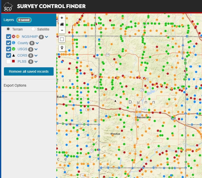
The Wisconsin State Cartographer’s Office has created, and maintains, a survey control finder
application for these, and other available, monuments. The metadata for each individual
control point can be obtained through this site.
(https://maps.sco.wisc.edu/surveycontrolfinder)
12Parcel Mapping
Parcel Geometries
Layer Status Maintenance Phase
Progress toward completion/maintenance phase: The Dunn county-wide parcel layer is in a
maintenance phase, with several identified obstacles to be addressed before the parcel fabric
can be considered cadastral quality. In Dunn County, 100% of the county’s parcels are
available in a commonly-used digital GIS format.
Projection and coordinate system: Although the Dunn County parcel layer is built and
maintained within the NAD_1983_HARN_WISCRS_Dunn_County_Feet, in house, it is submitted
to the state parcel mapping project in their designated NAD_1983_HARN_Wisconsin_TM
system. (meters)
Integration of tax data with parcel polygons: The county does not have a parcel polygon
model that directly integrates tax/assessment data as parcel attributes. The county however,
has the ability to export a text file of tax/assessment data, and join that table to the polygon
features based on PIN.
Esri Parcel Fabric/LGIM Data Model: The county does not use or plan to implement the Esri
Parcel Fabric Data Model, and/or Esri’s Local Government Information Model.
Online Parcel Viewer Software/App and Vendor name:
WebGUIDE Xtreme (WGX) – from contractor/vendor Applied Data Consultants
(http://dunncowi.wgxtreme.com/)
Unique URL path for each parcel record:
Yes. There are two URLs that can be utilized to link directly to a parcel record
Via WGX :
http://dunncowi.wgxtreme.com/?parcelid=[insert PIN number]
(ex. http://dunncowi.wgxtreme.com/?parcelid=1701622813312100001 )
Via GCS:
https://dunnportal.co.dunn.wi.us/GCSWebPortal/Search.aspx?ParcelNumber=[ insert PIN number]
(ex.
https://dunnportal.co.dunn.wi.us/GCSWebPortal/Search.aspx?ParcelNumber=[ 1701622813312100001 )
Custodian
Our current process requires the land information officer and the GIS specialist to administer
and maintain the polygon and PIN numbering elements of the parcel polygon fabric within the
ESRI ArcMap (v. 10.5) desktop environment. The real property lister is responsible for the
tax/assessment data maintenance within our newly implemented GCS Land Nav software suite.
Maintenance
Update Frequency/Cycle. In house parcel polygons are updated, usually, daily. This updating
may be triggered by a number of circumstances including, but not limited to, identified
corrections needed, (phone calls, internal requests, walk in landowners and the like) splits,
merges and new parcel additions, which is rare.
This polygon layer, which is then supplied to our website hosting vendor (ADC), is normally
updated at least monthly, or more frequently if needed.
Standards
Data Dictionary:
Does not currently exist. Dunn County plans to create both a data dictionary and metadata for
the parcel data within the next three years. Our current metadata is old and out of date. (See
Project #6.)
Dunn County’s annual submission to DOA as part of WLIP requirements meets their standard
for acceptance. The 2018 submission was version 4 and Dunn County plans to adhere to future
submission requirements, as they are potentially updated or changed.
13Assessment/Tax Roll Data
Layer Status
Progress toward completion/maintenance phase: NA
Tax Roll Software/App and Vendor name:
Property Assessment & Tax Billing Module – from contractor/vendor GCS Software
Municipal Notes: NA
Custodian
The assessment data is produced and maintained by the land information office, and primarily
the real property lister within that section.
The tax billing and collection is administered by the Dunn County Treasurer’s Office, in
conjunction with the land information section.
Maintenance
Maintenance of the Searchable Format standard: To maintain the Searchable Format
standard, the county will be utilizing the built in V4 and xml export functionality through GCS
suite of land records management software. This will be a welcomed streamlining of this
export process, as opposed to what we are used to through our previous benchmark
submittals.
Searchable Format Workflow:
The county maintains parcel/tax roll data in such a way that requires significant formatting
every year—whether by the county staff in-house, or a third-party contractor/vendor. This
statement is especially true for our previous benchmark parcel dataset submissions. It is our
vision that the newly implemented GCS suite of software will allow us to export and create a
searchable format standard parcel layer with a minimum amount of hands on manipulation
that we have done in the past.
Standards
Wisconsin Department of Revenue Property Assessment Manual (2018 WPAM) and attendant
DOR and DOA standards
DOR XML format standard requested by DOR for assessment/tax roll data
Non-Assessment/Tax Information Tied to Parcels
e.g., Permits, Easements, Non-Metallic Mining, Brownfields, Restrictive Covenants
Layer Status
Although not actually a layer, Dunn County residents and tradespersons can now access,
review and retrieve sanitation, zoning and other permits through the GCS Permit Tracking
module of our public web interface.
Custodian
Dunn County Environmental Services Department (Surveying, Zoning, Land Conservation and
Solid Waste.)
Maintenance
The Dunn County Environmental Services Department will continue to issue, and administer,
the permitting processes within their divisions. Their work process has now changed to include
this GCS integration into the land records management system.
14Standards
Permitting standards as dictated by local, state and federal ordinances and policies.
ROD Real Estate Document Indexing and Imaging
Layer Status
Grantor/Grantee Index:
Images are now available by Volume/Page or Document # starting from our first recorded
documents circa 1860’s. All Certified Survey Maps and Plats are scanned into Laredo. You can
search by Grantor/Grantee beginning in 1980. We are continuing to back index by
grantor/grantee so the back index date is always changing.
Tract Index:
A tract search by Legal Description is available beginning January 1, 2000. The documents are
entered using a PLSS based system. The only match for a PIN based system is the municipality
3 digit code. (e.g. City of Menomonie is 251.)
All document types are indexed using this PLSS tract system. This would include, but is not
limited to, mortgages, satisfactions, and all land records related documents.
Imaging:
Dunn County continues to digitally image every document that is recorded. The Register of
Deeds Office is also in the process of scanning very old images all the way back to book 1, or
the first recorded documents in Dunn County.
ROD Software/App and Vendor Name: : Laredo/Tapestry by Fidlar, AVID. ROD documents
are available online for a subscription/fee.
Custodian
County Register of Deeds
Maintenance
The Dunn County Register of Deeds Office is staffed with a full time, elected, ROD as well as 3
part time, deputies.
Standards
s. 59.43, Wis. Stats. Register of deeds; duties, fees, deputies.
ch. 706, Wis. Stats. Conveyances of real property; Recording; Titles.
15LiDAR and Other Elevation Data
LiDAR
Layer Status Static
Most recent acquisition year: 2007
Accuracy:
Horizontal accuracy is sub-meter
Vertical accuracy is 0.52 foot (0.26 foot RMSE) at the 95% confidence level.
Post spacing: 1 meter
Contractor’s standard, etc.:
ASPRS Class II
Next planned acquisition year: Potentially 2019
Custodian
Dunn County Land Information Office
Maintenance
The 2007 LiDAR raw dataset is a static series (tiles at 5000’ x 5000’) of x,y,z and i ascii tab files
archived and stored as both bare earth, and first return sets of data. These raw data files are
seldom used, but are sometimes provided, and/or sold, to educational and other geospatial
agencies that have the means to produce tangible products from these raw files. The data
resides on a county network disk based server and are backed up twice a day.
Standards
Mapping accuracy meets FEMA Appendix A Specifications for LIDAR Flood Plain Surveys with
vertical accuracy standards of +/- 18.5 cm.
LiDAR Derivatives
e.g., Bare-Earth Digital Terrain Model (DTM), Bare-Earth Elevation Contours, Bare-Earth Digital
Elevation Model (DEM), Digital Surface Model (DSM), etc.
Layer Status Static
In 2008 an ESRI LiDAR derived file geodatabase terrain dataset was provided by the
Department of Natural Resources (DNR) as a bi-product of the collaborative effort between
them and FEMA. This useful digital elevation modeling tool has been provided to those
departments that have the software, and need, to use it.
Custodian
Dunn County Land Information Office
Maintenance
Not required, static dataset that is backed up on a regular basis
Standards
In conjunction with the FEMA and DNR 2008 floodplain hydro engineering project for Dunn
County
Other Types of Elevation Data
Layer Status Static
2 foot and 10 foot contour layers (derived from our 2007 LiDAR project) both in shapefile
format and autocad (.dwg) format. Lines are 3D polylines with attributes.
Custodian
Dunn County Land Information Office
16Maintenance
Not required, static dataset that is backed up on a regular basis
Standards
See LiDAR standards above
Orthoimagery
Orthoimagery
Layer Status Static
Most recent acquisition year: 2017
Resolution: 6”
Contractor’s standard: This data set was tested in accordance with Geospatial Positioning
Accuracy Standards Part 3: National Standard for Spatial Data Accuracy (NSSDA), FGDC-STD-
007.3-1998 which is then related to NMAS as defined in Appendix 3-D Section 2. The RMSE of
29 well defined control points in the orthoimagery was tested with a resultant RMSE of 0.25'.
NSSDA horizontal accuracy is 1.7308*RMSE_r or 1.7308*0.25 = 0.43'. NSSDA Horizontal
accuracy meets or exceeds the project requirement of RMSECustodian
N/A
Maintenance
N/A
Standards
N/A
Address Points and Street Centerlines
Address Point Data
Layer Status Maintenance Phase
The land information office of Dunn County administers the rural addressing program for the
County. The GIS portion of this address work consists of maintaining a point file feature class
associated with the geodatabase used to drive the E911 mapping and dispatch center data.
Currently containing 16,878 unique address points, this feature set also includes the physical
addresses for 7 Villages (Colfax, Knapp, Ridgeland, Wheeler, Boyceville, Downing and Elk
Mound) and 1 City (Menomonie.) Currently, there is not a good line of communication
between the Villages and the land information office in regards to address maintenance. The
current points were derived from the GIS parcel layer, extracted as a centroid of the parcel, and
then attributed with the physical address of record. This global centroid creation was done
around year 2007, and the point file has been maintained and updated ever since. In the winter
of 2018, land information staff made a concerted effort to place the address point within the
parcel it belongs to, while representing the point of access as best we could. Once this was
completed, we did a spatial join owner name upgrade on the entire dataset. This was a much
needed update, as the owners had not been updated since that initial 2007 push. The City of
Menomonie has been more cooperative in providing corrections to the existing database, as
well as providing addressing schemas for the new subdivision lots created within the City
limits. These site addresses are also entered into the GCS land records management system,
and linked to the appropriate parcel as a physical address. (not necessarily the mailing address,
which is a separate table.)
Custodian
Dunn County Land Information Office
Maintenance
Inherited from the Dunn County Zoning Office in January of 2010, the Dunn County rural
address program has grown and evolved along with the new technology that becomes
available. Currently a rural address applicant has a variety of ways to submit and apply for a
rural address (also referred to as a fire number.) 95% of our new applicants complete the
required form, and make payment, online.
The applicant can read through the informational content and become informed as to the
history, process and importance of the rural addressing program. The availability to complete
an on-line application allows the applicant to complete the process from a remote computer
and supply the appropriate payment with a convenient credit card process. The applicant can
also download the application form, use postal mail and include a personal check or cash
payment as they prefer. We also encourage the applicant to visit our office for a more
personal experience. Once the application is received, it is vetted, approved and the number is
assigned, the new information can now be updated to the GCS land records management
system as well as the aforementioned address feature dataset with the E911 GIS mapping. The
new address signs are ordered, and within about a month the delivered signs will be available
for pick up and self-installation by the applicant and/or their representative. An 8’ steel post
and the mounting hardware are included in the $75.00 fee for a new sign. Replacement signs
can also be ordered, the same way, for a $30.00 fee. In 2017 we offered the $50.00 buy up
option of having county staff install the sign.
18Standards
Chapter 23 uniform system for numbering properties and principal buildings in Dunn County.
adopted in September of 2009.
Currently we use ESRI address locators that integrate into the E911 GeoLynx dispatching
system.
The County does plan to integrate the NENA NG9-1-1 GIS Data Model as time permits
Building Footprints
Layer Status
Dunn County does not have a building footprints layer.
Custodian
NA
Maintenance
NA
Standards
NA
Other Types of Address Information
e.g., Address Ranges
Layer Status
For Dunn County, this ranging topic would be covered in the next section “Street Centerlines”
Custodian
NA
Maintenance
NA
Standards
NA
Street Centerlines
Layer Status Maintenance Phase
The Dunn County centerline layer is also a product of the E911 mapping project geodatabase.
Dunn County GIS staff does maintain this centerline dataset.
Custodian
Dunn County Land Information Office
Maintenance
Centerline layer is maintained on an as needed basis. Reasons for updating may including new
subdivisions/platting; recent road reconstruction projects; error correction from previous
versions; address “to-from” ranging adjustments as request by the E911 department; general
topological cleanup based on new photography or other more accurate sources.
Standards
Chapter 23 uniform system for numbering properties and principal buildings in Dunn County.
adopted in September of 2009 drives the “to-from” ranges based on a grid system
implemented in the early 1990’s.
Currently we use ESRI address locators that integrate into the E911 GeoLynx dispatching
system. This centerline data is also part of the E911 dispatching model.
19 The County does plan to integrate the NENA NG9-1-1 GIS Data Model as time permits. Dunn
County has participated in the recent activity related to standardization of centerline data
across the State of Wisconsin.
Rights of Way
Layer Status 45% complete
We have much work to do on the Dunn County right of way layer. When we contracted out
our parcel mapping in the early 2000’s, the consulting mappers, did not do an adequate job of
delineating the right of way boundaries. Road widths were estimated, fee title rights of way
were ignored, plats and surveyed private roads were overlooked, so in the end we have a very
inconsistent and inaccurate representation of the road rights of way in our county. As time has
passed, and the parcel mapping has moved “in house”, if there is an evident error or omission
noticed by the GIS tech or LIO, the area will be re-mapped and the proper procedures will be
followed to reconstruct the rights of way boundaries in those certain area. (LIO note: This
status remains very close to what we wrote in the 2015-2018 mod plan. Although we have
tackled some of the more obvious problems with our right of way layer, we do not have an
organized project in place to allocate and mandate staff time and resources to complete this
task. It is our goal, in this next 3-year plan to make a dedicated effort to work on this
troublesome and rather elusive problem. See Project #7.)
Custodian
The Land Information office responsibilities include continual editing and updating of the
County’s digital base layers, associated databases, and metadata for all of the datasets that are
offered for public and internal use.
Maintenance
The land information office staff will set this right of way parcel cleanup as a priority for the
next 3 years. It has come to our attention, through the County Surveyor’s office and the Dunn
County highway department, that there are some older county road projects that were never
processed through the real property listers office, in other words, the right of way that was
obtained in fee title, was never listed. We have identified 2 such situations and are working on
addressing those. There will be more of these circumstances that will need to be identified and
fixed as we work through this part of our parcel mapping fabric. We will set the county
highways as a top priority as there may be other unidentified situations that occur, where
there are plats and recorded documents that we can use to help guide us along the re-
mapping of these rights of way. Town roads may not be as critical, as most of the ownership
goes to the centerline along these designated roads. Federal and State highways will also be
scrutinized to assess the correctness of our current parcel mapping.
Standards
No specific standards on this layer
Trails
e.g., Recreational Trails
Layer Status Maintenance Phase
The DNR trails in Dunn County (Red Cedar, Chippewa River, Stokke and Hoffman Hills Trails) are
mapped and attributed (Mile marker posts) as part of the Dunn County transportation layer
described above. As a recent and maintained update to the E911 mapping system, a county
ATV layer was added as an overlay to the transportation layer. This ATV layer only includes those
portions of public roads as designated for use by ATV’s. Once departed from the public road,
there is no formal mapping for the off-road trail system.
20Custodian
Dunn County Land Information Office (we also rely on the Dunn County Highway Department
to alert us when a resolution is proposed that adds ATV travel rights across public roads.)
Maintenance
GIS/LIO staff maintains this layer. These trails do not change significantly over the course of
time, so there is not a lot of maintenance needed here. If any new trails are added, they will be
updated on the transportation layer as needed.
Standards
No specific standards on this layer
Land Use
Current Land Use
Layer Status Static
Most often used land use layers are usually obtained from different sources, outside of the
land information office. An example would be the Wiscland1 land cover maps available
through the Wisconsin DNR. Normally the land information office doesn’t participate in the
local Township, Village and/or City planning processes. Those local municipalities, however,
may reach out to other departments within the County to provide them with experienced
guidance and the expertise needed to conduct a variety of land use activities. Some examples
would include groundwater guardianship, concentrated animal feeding operations (CAFO) and
broadband mapping, just to name a few. The Dunn County Land Information Office serves as a
technical resource to any number of outside departments when these unique, but important,
projects arise.
Custodian
Although we allow these rather large “outside” datasets to be stored on our network servers, it
is not up to the County to maintain datasets derived from an outside source.
Maintenance
The zoning/planning offices, as well as the land conservation office, both have competent and
experienced GIS users on staff. These staff create, maintain and distribute geospatial data and
maps, as determined by their individual disciplines, and their user’s unique needs. This may
include farmland preservation mapping, zoning/planning and density analysis, clean water, and
water resources management just to name a few. It is imperative that these separate offices,
being land information, and environmental services, become more of a cooperative unit within
the land records framework of Dunn County. (See org chart below)
21Standards
No County standards on datasets retrieved from outside sources. Normally these DNR, or
other, datasets provide the metadata for that feature class. There may also be errors and
omissions disclaimers when using outside data that need to be adhered to.
Future Land Use
Layer Status Static
As mentioned above, participating Townships generally coordinate with the environmental
services office for assistance with future use planning and mapping. Currently 16 of the 22
political townships in Dunn County are participants in the county zoning program. The other 6
are considered “un-zoned” townships and may, or may not, have their own planning and
subdivision ordinances in place. The environmental services office, including the branch of
Land Conservation, works, on a case by case basis, with each of these participating townships
as needed. Often, a key driving component for these land use planning activities, is a current
and up to date parcel layer. The land information office works with, and provides support to,
the environmental services office as requested.
Custodian
The Land Conservation office responsibilities include designing and installing soil erosion
control and water quality practices for agricultural, commercial, and recreational development,
and developing land and resource management plans. The office maintains the agricultural
planning and management records, farmland preservation participation, and the soil survey in
cooperation with NRCS.
The Planning/Zoning office responsibilities include maintaining and enforcing the county’s
comprehensive zoning ordinance for 16 of the 22 townships in the county and sanitary and
private sewage system ordinances. This section is also entrusted to assist the constituents of
Dunn County with directional planning and development advice as needed.
(See Surveying custodian duties in the PLSS section of this document.)
Maintenance
Any dataset, and maps, that are created through an unique project as mentioned above, will
be organized and stored/archived on the Dunn County server network. It is up to the
individual departments, or individuals, who created the data, to decide who will maintain it.
We have stressed to these users that they should also create a metadata set to accompany the
feature class(es).
Standards
s. 66.1001, Wis. Stats. Comprehensive planning.
Future land use maps are typically created through a community’s comprehensive planning
process. Future land use mapping for a county may be a patchwork of maps from
comprehensive plans adopted by municipalities and the county.
22Zoning
County General Zoning
Layer Status Maintenance Phase
The County does maintain a GIS representation of county general zoning boundaries. As a
rule, the parcel fabric maintained by the land information office is the driving base layer
behind the zoning map. More specifically, a zoning code is assigned to a parcel, within the
land records management system, and then this code is used to create maps, do planning
analysis and other GIS functions based on that designated zoning code criteria.
Custodian
There are 2 custodians at this time. The land information office and the zoning office. Both of
these departments have editing rights to make corrections, changes, edits, and/or updates to
the zoning code on any given parcel. It is preferable that the zoning office do the majority of
these zoning edits and changes. Currently the only zoning edits the land information office is
making, is when a zoned parcel is split into 2 or more children parcels. The parent zoning is
usually carried over to the children parcels. Any merging of parcels may need guidance from
the zoning office staff if 2, or more, different zoning designations are being combined.
Maintenance
Again, it is preferable business practice to have the Dunn County zoning office take complete
ownership of this field. As mentioned, the property lister or GIS tech/LIO will carry previous
zoning codes over when splits occur.
Standards
Please review the Dunn County comprehensive zoning (Chapter 13) ordinance available on the
main Dunn County web page
Shoreland Zoning
Layer Status No layer (Use parcel layer and buffering tools)
Administered by county but not in GIS format.
Farmland Preservation Zoning
Layer Status
Administered by county but not in GIS format. (Although those specific zoning designations
can be derived through the overall zoning map) Note: the municipalities within Dunn County
that fall under this designation are Townships of Grant, Lucas and Wilson. Also this mapping is
available through the Wisconsin DATCP website (https://datcpgis.wi.gov/maps/?viewer=fpp)
Year of certification: Tax year 2017 (From DATCP website)
23Floodplain Zoning
Layer Status Static
The County does maintain a GIS representation of floodplain zoning boundaries.
The county’s floodplain zoning GIS data is the same as/identical to the FEMA map.
FEMA Flood Insurance Rate Maps (FIRMs) can be changed through “Letters of Maps Change,”
which is comprised of a few things: Letters of Map Amendment, Letters of Map Revision, and
Letters of Map Revision Based on Fill. These are documents issued by FEMA that officially
remove a property and/or structure from the floodplain. They are collectively called Letters of
Map Change.
Custodian
Dunn County Land Information Office (line work) along with the Dunn County Zoning Office
(Enforcement and administration of this layer)
Maintenance
As determinations are completed and approved by FEMA and/or WDNR standards.
Enforcement and administration of this section is through the Dunn County Zoning Office. Se
chapter 15, “Dunn County Floodplain Ordinance” for specific details.
OFFICIAL MAPS & REVISIONS
The boundaries of all floodplain districts are designated as floodplains or
A-Zones on the maps listed below and the revisions in the Dunn County
Floodplain Appendix. Any change to the base flood elevations (BFE) in the
Flood Insurance Study (FIS) or on the Flood Insurance Rate Map (FIRM)
must be reviewed and approved by the DNR and FEMA before it is effective.
No changes to regional flood elevations (RFE's) on non-FEMA maps shall be
effective until approved by the DNR. These maps and revisions are on file
in the office of the Dunn County Zoning Administrator, Dunn County, WI.
If more than one map or revision is referenced, the most restrictive
information shall apply.
Standards
FEMA standards, Wisconsin DNR regulations and Dunn County Zoning Ordinance number 15
(Dunn County Floodplain Ordinance.)
Airport Protection
Layer Status Static
The County does maintain (in conjunction with the City of Menomonie) a GIS representation of
airport protection zoning boundaries
Airport protection zoning map depicts:
Height limitation restrictions (City would enforce their interests, and the County would
review those potential inclusions into this zone(s) that fall outside of the City limits.
(Note: extraterritorial zoning also applies 1.5 miles beyond the City limits so there may
be some approving and objecting authority given those criteria.)
General zoning overlay for airport protection (City would enforce their interests, and the
County would review those potential inclusions into this zone(s) that fall outside of the
City limits. (Note: extraterritorial zoning also applies 1.5 miles beyond the City limits so
there may be some approving and objecting authority given those criteria.)
Other: Airport protection boundary falls into 4 different jurisdictions; City of Menomonie
(actual airport and runways are in the City limits;) Town of Menomonie, Town of Red
Cedar and a small portion of the Town of Spring Brook.
24Custodian
The City of Menomonie along with the County of Dunn if required.
Maintenance
The layer is static and is not usually updated. The City of Menomonie maintains this layer and
the County has acquired a copy to review and protect those interests outside of the City limits.
Standards
FAA, City Zoning and County Zoning
Municipal Zoning Information Maintained by the County
e.g., Town, City and Village, Shoreland, Floodplain, Airport Protection, Extra-Territorial,
Temporary Zoning for Annexed Territory, and/or Zoning Pursuant to a Cooperative Plan
Layer Status
Dunn County Zoning Office and the land information office maintains the zoning information,
mapping, and per parcel designation, for 22 Townships and the City of Menomonie. The 7
Villages within our county limits are responsible for their own zoning. Before 2010, some of
these Villages had their zoning codes updated in the land records management system, but
this department no longer updates or maintains these codes.
Custodian
Dunn County Zoning office, along with the Dunn County Land Information Office.
Maintenance
There are 2 custodians at this time. The land information office and the zoning office. Both of
these departments have editing rights to make corrections, changes, edits, and/or updates to
the zoning code on any given parcel. It is preferable that the zoning office do the majority of
these zoning edits and changes. Currently the only zoning edits the land information office is
making, is when a zoned parcel is split into 2 or more children parcels. The parent zoning is
usually carried over to the children parcels. Any merging of parcels may need guidance form
the zoning office if 2, or more, different zoning designations are being combined.
Standards
Please review the Dunn County comprehensive zoning ordinance (Chapter 13) available on the
main Dunn County web page
Administrative Boundaries
Civil Division Boundaries
e.g., Towns, City, Villages, etc.
Layer Status Maintenance Phase
Dunn County has 100% completion of the 22 Township, 7 Villages and 1 City municipal
boundary layers. This is the framework for our election boundaries as described below.
Custodian
Dunn County Land Information Office
Maintenance
May be updated when annexations occur, or better geospatial data (PLSS) is available.
Standards
Boundaries are mostly determined using a combination of PLSS data and existing parcel data.
There are no formal standards adhered to on this layer.
25School Districts
Layer Status Maintenance Phase
Progress toward completion/maintenance phase: It is estimated that we are at 90%
completion on this layer.
Relation to parcels: Layer is derived using a combination of the municipal layers and the
parcel layer attribute as noted below.
Attributes linked to parcels: “School District Number” and “School District” are the 2
associated fields used on the V4 submission. The school district number is the state code
assigned to that jurisdiction, and then an alpha type designation is cross referenced.
(e.g. School District Number = 1176; School District = COLFAX SCHOOL DISTRICT.)
Custodian
Dunn County Land Information Office
Maintenance
Ongoing. It is our hope that the State Department of Public Instruction would someday be
able to provide our county with a map that they believe is accurate, and assist us with any
imperfections that may exist in this layer.
Standards
We do not conform to any standards related to this layer other than using the State provided
school code that matches the school district designated.
Election Boundaries
e.g., Voting Districts, Precincts, Wards, Polling Places, etc.
Layer Status Maintenance Phase
The County does manage a GIS representation of the municipal wards and polling locations
Custodian
The Dunn County Land Information Office (in conjunction with the County Clerk’s office as well
as any individual local municipal office that may notice inconsistencies in our election
boundary mapping.)
Maintenance
Somewhat dynamic layer especially when annexation and re-districting situations occur. The
local municipal, and county clerks as well as the State Legislative Technology Bureau and the
Wisconsin Elections Commission staff are very helpful in identifying issues, then working with
our department to offer solutions to those problems.
Standards
Municipal Wards: Legislative Technology Services Bureau data model
Polling locations are an internal point layer that we maintain for informational purposes
Utility Districts
e.g., Water, Sanitary, Electric, etc.
Layer Status
Dunn County does not have utility district layers available at this time
26You can also read