EARL G. AND INEZ BATTS RECREATION COMPLEX - TOWN OF SURF CITY MASTER PLAN REPORT - Surf City, NC
←
→
Page content transcription
If your browser does not render page correctly, please read the page content below
EARL G. AND INEZ BATTS RECREATION COMPLEX > MASTER PLAN

EARL G. AND INEZ BATTS
 RECREATION COMPLEX

   TOWN OF SURF CITY
     MASTER PLAN REPORT
      Adopted: April 16, 2021

                                                                  1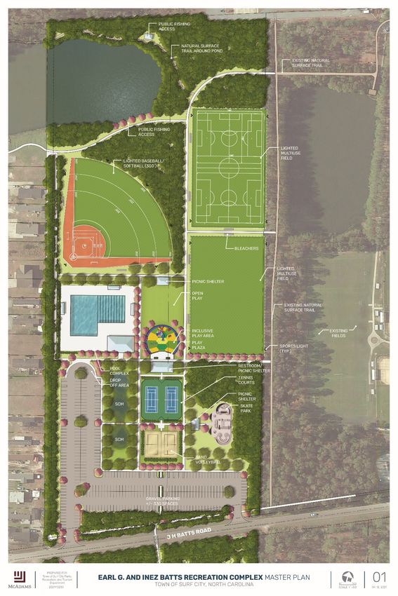
EARL G. AND INEZ BATTS RECREATION COMPLEX > MASTER PLAN

INTRODUCTION
Earl G. and Inez Batts Recreation Complex will be      SITE DATA
located next to the existing Surf City Community       Address
Center and Athletic Complex, located at 201            N and S side of J H Batts Road, adjacent to Surf
Community Center Drive. The Town hopes to continue     City Community Center
to provide high quality recreation amenities on this   Area
new park property for the growing Surf City            53.80 Acres, 39.50 Upland Acres
community and address the recreation needs that        Zoning
were revealed through the comprehensive park and       RA- Rural Agricultural
recreation master planning process.                    Land Use
                                                       Vacant Rural Agricultural Tract
                                                       PIN/ Parcel
                                                       4235-23-1997-0000; 4253-22-7321-0000

            Site
          Location

Figure 1 Vicinity Map

                                                                                                    2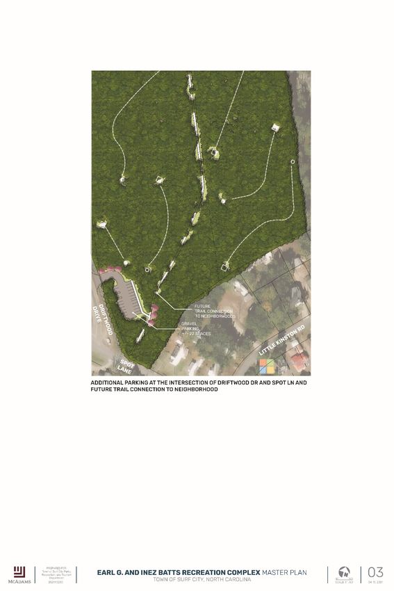
EARL G. AND INEZ BATTS RECREATION COMPLEX > MASTER PLAN

Context
The Town of Surf City intends to acquire the subject property, herein called Batts Property with a vision
to provide recreation amenities the growing community needs. The property is located off NC Highway
50 and 210, along J. H. Batts Road and adjacent to the community center which has athletic fields, dog
park, tennis courts, and walking trails. To the east of the property, is undeveloped land owned by Royal
Palm Development Corp. Surrounding to the west and south are subdivisions such as Royal Palms
subdivision, J H Batts subdivision, and Sears Landing community center. To the north is the Karen
Beasley Sea Turtle Rescue & Rehabilitation Center. This is a very popular tourist destination and
nationally known sea turtle rescue.
The nearby destinations for the Town of Surf City include:
    > Surf City Community Center Complex
    > Karen Beasley Sea Turtle Rescue & Rehabilitation Center
    > Public beach access
    > Intercoastal waterway

 Karen Beasley Sea Turtle                                                Surf City Parks, Recreation,
 Rescue & Rehabilitation                                                 and Tourism Office
 Center

                                                                                     Vacant Land –
                            Royal Palms                                              Royal Palms
                            Subdivision                                              Corp

    N
                                          Lanier’s Campground

Figure 2 Site Context Map

                                                                                                            3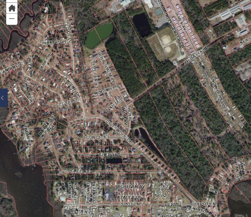
EARL G. AND INEZ BATTS RECREATION COMPLEX > MASTER PLAN

History
During the late 1940s, the then largely undeveloped island was used by the military for missile testing,
and many of the original oceanfront launch/observation towers are still present. The island portion of
the neighborhood has been a second home area since the 1950s. With the Marine Corps base in
Jacksonville, a short commute from the north, many military personnel have found it a convenient place
for weekend and temporary housing.
As the popularity of the North Carolina coast increased, all the island areas became targets of residential
and ancillary commercial development. Most notable was the increase in condominium projects, which
were quickly over-built. A national recessionary period with historically high interest rates, and a change
in the tax laws further dampened the market for this type of product. Developers and lenders alike were
reluctant to initiate condominium or most second home type projects.
Topsail Island has remained relatively quiet from a development standpoint until just recently. Most of
the higher-priced, luxury residential development has taken place in Wrightsville Beach, Figure Eight
Island, and Emerald Isle. Topsail Island’s reputation was hindered somewhat by the large number of
mobile home developments on the island, which appear to be more common there that in other coastal
communities. Slowly, however, these developments are being removed to make room for multi-family
projects.
There remain a number of large undeveloped tracts on the island, however most of the available land
remains on the mainland and is much less restricted from a zoning and environmental standpoint.
However, this mainland property is far less costly than the island property due to the less desirable
location and large number of wetlands.
The mainland area along Highway 50 has had a spurt of commercial growth for the past five years. While
still low to medium in density, it is beginning to become the primary commercial area in the greater
Topsail area.
There is no significant historic data available on either of the tax parcels. According to the Yellow Book
Appraisal document, the property was owned by Batts family since 1974, largely undeveloped. There are
no structures on site except some selective clearing for trails that connect to the community center to J
H Batts Road.

Demographics
Per the 2010 United States Census, the Town of Surf City had a population of 3,449. The median age was
roughly 37 years old, those 18 years or older comprised 75.6%, five years old or younger 7.7%, and the
population 65 years of age or older was 15.9%. The racial makeup of the Town is 88.9% white, 3% Black
or African American alone, .08% Asian alone, some other race 2%, and 5.2% two or more races.
The median household income was $75,556, with 10.1% of the population living at or below the poverty
level. Surf City residents’ education attainment, according to the U.S. Census, amounted to 44.1%
holding bachelor’s degree or higher.

                                                                                                          4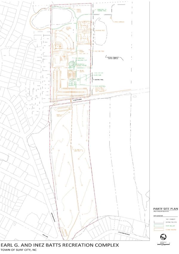
EARL G. AND INEZ BATTS RECREATION COMPLEX > MASTER PLAN

SITE INVENTORY + ANALYSIS
The Batts property is 53.08 gross acres out of which 39.50 acres are uplands area. It is comprised of two
tax parcels bisected by J H Batts Road. The northern parcel has 23.47 acres of the uplands area while the
southern parcel has 16.03 acres of uplands area and the rest is covered by open waters and wetlands.

Development Guidelines
Zoning
The RA rural agricultural district primarily allows single family residential development. The regulation
also encourages rural farming and preservation of open space.

Building Setbacks
Max front yard-40’
Minimum side yard-20’
Minimum rear yard-30’

Utilities
Water and sewer are in proximity of the site. The electricity service is provided by Four County while
telephone service is provided by AT&T. There are no major easements located on either of the tax
parcels.

Parking
According to Surf City Unified Development ordinance, each parking space shall be a minimum of nine
feet by eighteen [feet] (9' × 18') with a minimum drive aisle of twenty-two (22) feet for two-way
traffic. The maximum width of a driveway is twenty-four (24) feet in width at the street.

Landscaping Requirements
According to Surf City Unified Development ordinance landscape requirements section, a Type A
(screen/ buffer) perimeter landscaped area of five feet (5’) shall be provided; property line abutting the J
H Batts Road shall maintain minimum depth of ten feet (10’). In addition, along the street frontage,
streetscape provision shall include trees at 20’ on center and a maximum of 40’ on center for larger
canopy trees. For Type C- interior landscaping, no parking space shall be more than sixty (60) feet from
the base of a canopy tree. Landscape islands shall be placed at the end of each parking isle. Landscape
islands shall be a minimum of one hundred sixty-two (162) square feet.
All required landscape areas are encouraged to be irrigated or utilize plants which are drought tolerant.
Planting size:
Canopy trees: at least eight (8) feet high above the ground and two (2) inches in caliper at the time of
planting
Shrubs: at least five (5) gallons in container size and three (3) feet above ground level

                                                                                                            5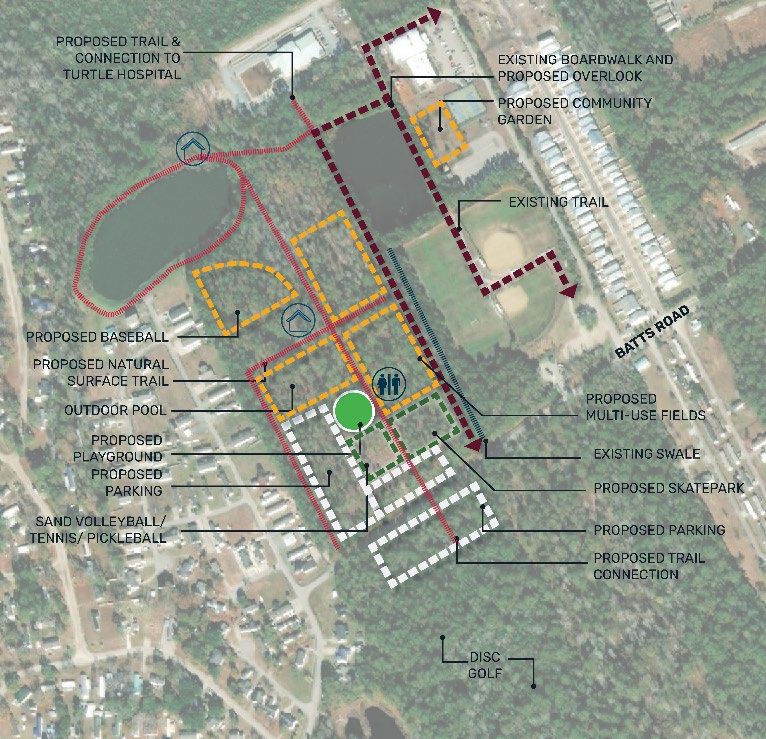
EARL G. AND INEZ BATTS RECREATION COMPLEX > MASTER PLAN

Note: Additional UDO requirements for site plan shall be followed during development of construction
documents such as stormwater management plan, outdoor lighting, and others not mentioned in this
document.

Permits
The Batts property resides outside of the CAMA jurisdiction; hence no CAMA permit will be required for
site development. Other anticipated permits will include NCDOT encroachment permit, erosion and
sediment control permit, and building permits required by the Town. In addition, USACE permit may be
required for trail development through the southern parcel. It is advised that the regulatory agencies be
consulted during the development of construction documents.

Inventory
Access
The site is accessible from J H Batts Road. There is also a natural surface trail and boardwalk that goes
around the community center building that winds through the woodlands and connects to the Batts
property. The trail connects to J H Batts Road.

Environmental
Floodplain
The southernmost part of the site is located in zone AE and X. AE zone is classified as an area inundated
by 100-year flooding, for which BFEs have been determined. X zone is classified as an area that is
determined to be outside of the 100–500-year floodplain.

Stormwater
The site is located in both Surf City and Pender County jurisdictions. Being that neither is a delegated
authority for managing stormwater the permitting will go to the DEQ Wilmington Regional office and
follow Coastal Stormwater Rules. SCMs for treatment of stormwater must follow the state manual for
Minimum Design Criteria. The project appears to be within a half mile of an SA water and will have to
treat stormwater to this commensurate level. Depending on the density of the proposed development
an option may be pursuable to minimize stormwater controls by minimizing impervious surface to less
than 12%. If a low-density permit is not pursued, then the rainfall event to be used for treatment of
high-density development shall be the 1-year storm rather than the 1.5 inch storm due to its location
proximate to an SA water. Further, either runoff volume match will need to be provided with release of
excess flows at a non-erosive velocity OR the SCM shall provide treatment without discharging in excess
of the pre-development conditions during the one-year, 24-hour storm event. The runoff volume in
excess of the one-year, 24-hour runoff volume shall be released at a non-erosive velocity at the edge of
the vegetated setback or to an existing stormwater drainage system. With regard to buffers and
setbacks, the development will be held to vegetated setbacks from perennial waterbodies, perennial
streams, and intermittent streams of at least 50 feet in width for new development and at least 30 feet
in width for redevelopment portions of the project.

                                                                                                            6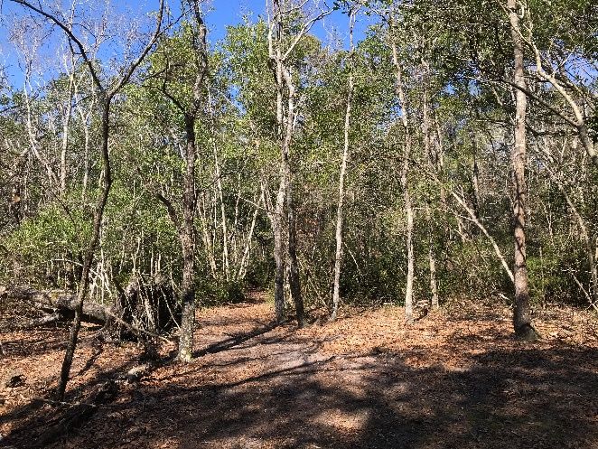
EARL G. AND INEZ BATTS RECREATION COMPLEX > MASTER PLAN

Open Water and Wetlands
The wetland delineation found that there was approximately 39.5 acres (74%) of upland area, 12.5 acres
(23%) of wetland, and 1.8 acres (3%) of non-jurisdictional open water on the property. To the south of
the land is the Intracoastal Waterway and marshland. Wetland delineation report is attached in the
appendices.

Trees and wildlife
Pine trees and live oak trees are the predominant tree on the property. Wildlife species include eastern
gray squirrel, groundhog, eastern cottontail, white-tail deer, raccoon, and common North Carolina birds.

Existing Conditions
J H Batts Road bisects the Batts property into two – a north and a south parcel and provides the
opportunity for easy vehicular access to both parcels. Both parcels are heavily wooded with a few areas
logged and selectively cleared. Much of the area of the southern parcel has been covered with
wetlands. While majority of the site has flat terrain, typical to coastal area, there are some areas within
the site that are 6-12% slope, according to the GIS topographic data.
The existing pond located on the northernmost end of the property is accessible via a boardwalk and
natural surface trail. The natural surface trail that runs north-south, parallel to the eastern boundary of
the north parcel is very popular among residents as it provides great opportunities to be in contact with
the nature. This trail also connects with the Karen Beasley Sea Turtle Rescue and Rehabilitation Center.
A sidewalk access along J H Batts Road will provide an opportunity for pedestrian access from Batts
property to community center property for surrounding residential neighborhoods.
Being adjacent to the community center complex and associated existing recreation amenities, the Batts
property improvements will need to be interconnected for seamless pedestrian circulation.

Figure 3 Boardwalk trail connection from community             Figure 4 View of the north pond from boardwalk trail
center

                                                                                                                      7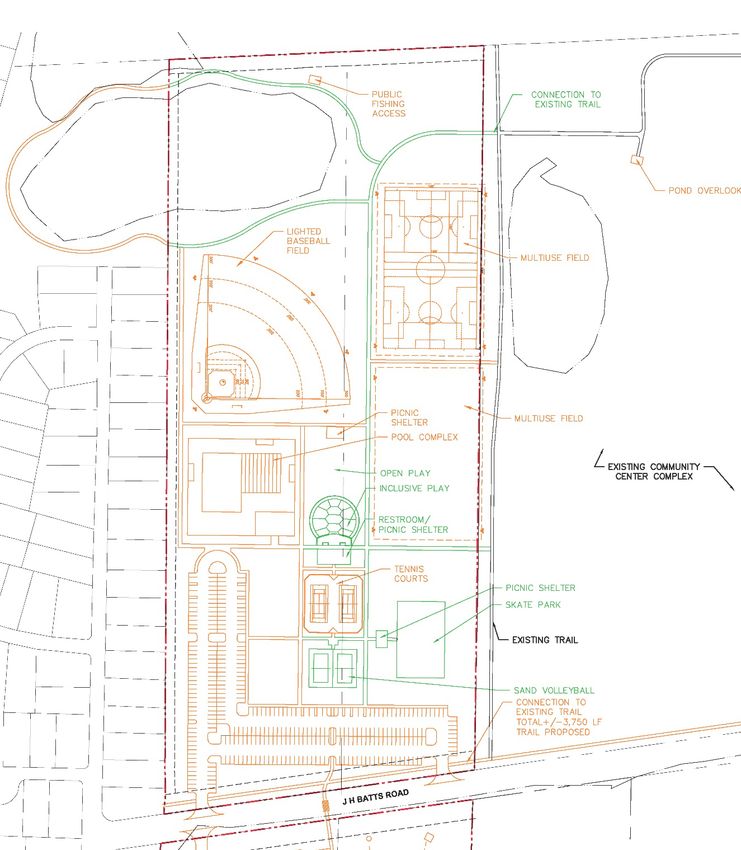
EARL G. AND INEZ BATTS RECREATION COMPLEX > MASTER PLAN

Figure 5 Existing trail connection to Turtle Rescue and             Figure 6 pond view from northern end of site
Rehabilitation Center

 Figure 7 Existing natural surface trail                            Figure 8 Site view from J H Batts Road

Figure 9 Existing vegetation on south parcel                        Figure 10 Trail connection to J H Batts Road

                                                                                                                   8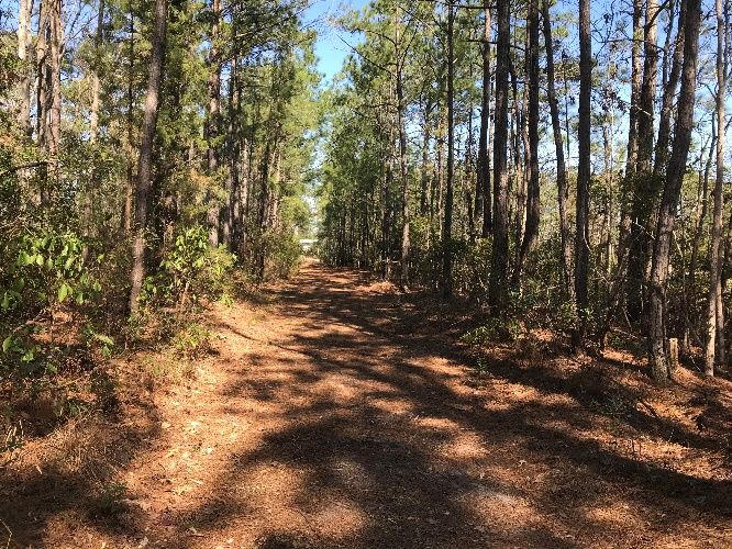
EARL G. AND INEZ BATTS RECREATION COMPLEX > MASTER PLAN

RECREATION NEEDS
Parks and Recreation Comprehensive Plan Community Engagement (2018-2019)
The data presented in the 2019 Surf City Comprehensive Parks and Recreation Master Plan points to
needed information regarding the needs and wants of the community as well as the Town’s goals for
providing future recreation opportunities for those who call Surf City home. Key findings that specifically
inform the recommendations for Earl G. and Inez Batts Recreation Complex are summarized below.

As part of the plan, a recreational needs survey was performed to uncover the needs and wants of those
residing in Surf City. A team of faculty and students from UNC Wilmington’s Parks, Recreation and
Tourism department administered a survey about park usage, desired programs and facilities, and
opportunities and constraints of the current park system. The survey garnered 612 responses, of which
361 were identified by participants as Surf City residents. A need for broader recreation opportunities
was revealed. Top-ranking amenities were bike lanes, sidewalks/pedestrian lanes, indoor swimming
pool, outdoor swimming pool, hiking trails/paths, pedestrian crosswalks, public restrooms, water access
amenities/sites/facilities, fitness equipment, and a skateboard park.

Conversations with key stakeholders revealed concerns about accommodating growing population of
Surf City and the surrounding area, while continuing to provide quality leisure services to current
residents. Suggestions to address this concern included acquiring property for parks and improving and
expanding facilities at existing parks. Much aligned with the general publics’ sentiment, stakeholders
also expressed the need for additional improved trails, paths and boardwalks for fitness walking/jogging,
more athletic facilities, and a pool. Additionally, stakeholders suggested that the Town consider
developing a skate park and expanding/improving the existing disc golf course.

Town of Surf City Advisory Committee Meetings
The Parks, Recreation, and Tourism Department updated and gathered feedback from the Advisory
Committee during various milestones of this project since land acquisition. The associated feedback
included support for proposed amenities, implementation timeframe, schedule, and funding support.

Community Engagement (2020)

The Parks, Recreation, and Tourism Department conducted two in-person public meetings to gather
feedback from residents on the schematic plans, in early 2020 before the pandemic. The staff made a
presentation followed by a survey questionnaire. A total of 89 people were in attendance and provided
strong support for park development (97%). While 97% supported park implementation through grant
funding and 71% supported tax monies. There was also a strong support for a skate park, also indicated
in the comprehensive planning public input process.

Online Public Engagement Survey (2021)

A brief, nine-question survey was developed to obtain a snapshot of the public’s preferences for
facilities and recreation programs at what will become Earl G. and Inez Batts Recreation Complex.
Participants were first asked about their level of support for the Surf City Parks, Recreation, and Tourism
Department and its current programs and facilities, including what funding mechanisms they support to

                                                                                                          9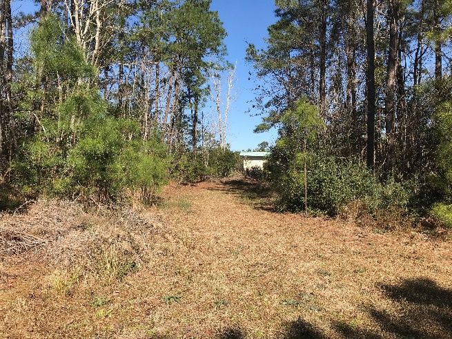
EARL G. AND INEZ BATTS RECREATION COMPLEX > MASTER PLAN

maintain, improve, and expand upon recreation programs and facilities in their community. They were
asked about their support for and recreation preferences they have for Earl G. and Inez Batts Recreation
Complex. Participants were also asked demographics questions to gather input on age, gender, and
location of residence.

The online survey was made available via SurveyMonkey platform from March 25, 2021 to April 9, 2021.
The Town promoted the survey for a two-week period on the Town’s website and social media
platforms.

The public outreach was very well received with 1,300 individuals responding to Town’s survey. Most
survey-takers reside within town limits, with respondents from neighboring Hampstead and Holly Ridge
making up the next highest reported locales. Most respondents (over one-third) represented those
between the ages of 35 and 44.

Nearly all respondents (98%) believe that parks, recreation, and tourism are important aspects of their
community, and nearly all respondents (96%) support the development of the new Earl G. and Inez Batts
Recreation Complex. The survey captured a variety of recreation interests enjoyed by the respondents,
including attending special events. Visiting parks and playgrounds, running/walking, fishing, playing disc
golf, and visiting the dog park ranked as the top five, respectively. Residents’ interest the Town of Surf
City’s special events was revealed via the survey. Respondents indicated that they frequently attend the
Town’s summer concerts and movies, as well as holiday events like the 4th of July Fireworks, Easter Egg
Hunt, and Christmas Tree Lighting.

The property that will become Earl G. and Inez Batts Recreation Complex boasts features that can
accommodate myriad recreational activities. Participants’ top five choices for amenities at the park, in
order, were walking/running/biking paths, an outdoor swimming pool, inclusive playground, public
fishing, inclusive playground, and skate park. The top five choices for recreation programs at the new
Earl G. and Inez Batts Recreation Complex were swim lessons, outdoor fitness classes, 5K races, beach
volleyball, and skateboarding programs.

Survey takers were asked about their funding source preferences to support parks, recreation, and
tourism in Surf City. Over one-third of respondents supported both an increase in user fees and support
general obligation bonds. Three-quarters of respondents support outside, and grant funding – while
fewer than 1/5 support increased property taxes.

Lastly, the survey sought to identify methods of communication most favored by the public.
Respondents indicated that they prefer getting their information about Earl G. and Inez Batts Recreation
Complex through social media, followed by notifications on the Town of Surf City’s website, and via
email.

                                                                                                           10
EARL G. AND INEZ BATTS RECREATION COMPLEX > MASTER PLAN
CONCEPT DEVELOPMENT
The recreation amenities planned for the new
recreation complex are a result of robust
community engagement process undertaken by
Town of Surf City Parks, Recreation, and Tourism
Department for over a period of two years. The
goal for the design team was to ensure that the
community’s vision for these programming and
park amenities is translated into an
implementable park master plan.
McAdams design team organized the site
amenities with the focus on “a park for everyone”
while ensuring phasing strategies for project
implementation. The site organization also takes
into consideration synergy between various
amenities, active vs. passive programming, and
interested user groups. Special consideration was
Figure 11 Schematic Plan showing tentative amenity placement
given to existing site features such as the pond
and the wetlands to avoid any land development
impact to these areas.
FINAL MASTER PLAN
The overall vision for the Earl G. and Inez Batts Recreation Complex is to create a recreation hub on the
mainland, within easy access from surrounding neighborhoods. The already existing athletic complex
and the community center support this vision.
The proposed park amenities associated with this master plan include a baseball field, two multipurpose
fields, an inclusive playground, outdoor pool, tennis, sand volleyball, and a skate park on the north
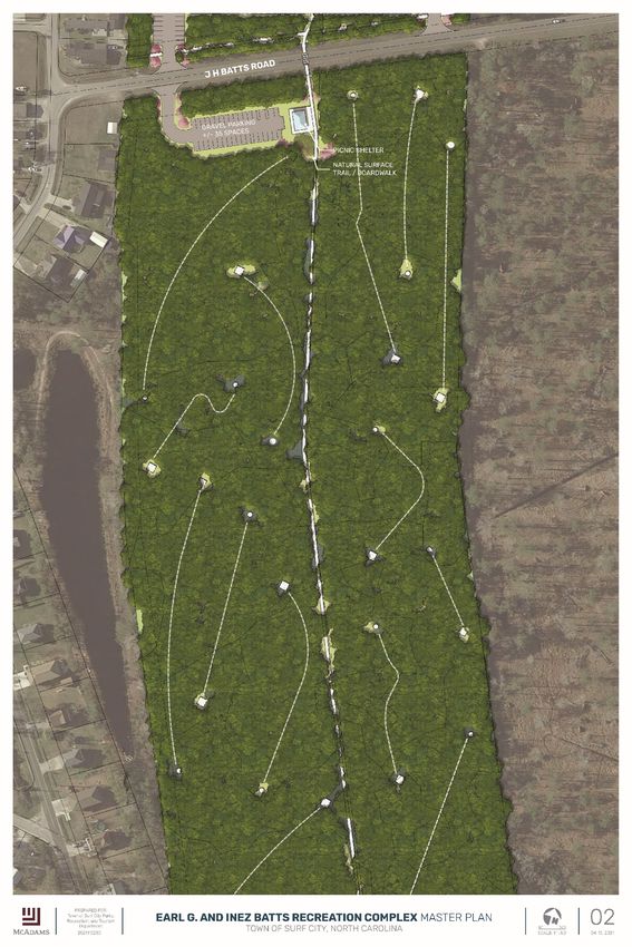
parcel and a new parking lot, shelter, and 18-hole disc golf course on the southern parcel.
As mentioned earlier, the utilities such as sewer, water, and electrical are in proximity of the site and
can be easily extended to the new park site. The overall infrastructure improvements needed for the site
will include site clearing, grading, and utility extensions. NCDOT encroachment permit will be required
for driveway access from J H Batts Road to both North and South parcels.
Vehicular circulation is kept along the perimeter of the site to provide uninterrupted and safe pedestrian
circulation throughout the site. All parking lots will be gravel surfacing. The largest parking area is
provided on the north parcel where concentration of amenities is located, and a dedicated parking lot is
provided for disc golf users on the southern parcel off J H Batts Road. In addition, the southern parcel
will have a small parking lot accessible from Spot Lane and Driftwood Road intersection.
11EARL G. AND INEZ BATTS RECREATION COMPLEX > MASTER PLAN
The baseball field occupies the northern end of the site,
closer to the pond along with two multipurpose fields. All
the athletic fields will be natural surface and their
regulation size affords programming for multiple age
groups with overlaid play lines. These fields will be
lighted for use after dark.
The inclusive play area is located centrally, in proximity
from other amenities. The idea is to provide convenience
for caregivers to entertain siblings while sports games
are in session. The playground area is considered all
Figure 12 Sea turtle sculpture as potential public art
inclusive – meaning it caters to all ages and ability levels (Sculpture by Sculptor Nancy Schön)
of children. A poured-in-place safety surfacing will
provide easy wheelchair access into the play space. The
play area will be surrounded by large canopy trees for
shade. In addition, a large open space to the north of the
play area could be used for informal play, such as, frisbee
throwing, game of tag, or kite flying.
Located just south of the play area is a restroom-picnic
shelter building which provides an anchor point for the
park amenities. A plaza area between the building and the Figure 13 Sand indentation left by baby turtle (Image
play area provides space for parents to socialize while kids source: U. S. Fish and Wildlife)
are playing.
A theme of sea turtles will be incorporated in the play
plaza in the form of a public art installation, should the
Town decide to pursue it. A metal carving symbolizing
the sand indentations left by baby turtles that mark
their journey from shore to ocean will be installed in the
pavement and a life size sculpture of adult sea turtle will
be added at the end of pavement markings. The play
area poured in place safety surface also follows the
pattern of turtle shell bringing this playful theme
together.
The tennis courts, sand volleyball, and skate park are in
proximity which creates a “hub” for Surf City youth to
engage in recreation activities of their choice. The
skatepark is designed as a “hybrid” skatepark, which
Figure 14 Inclusive play, skate park, and sports courts
includes the pump-track feature. It will serve a broad
skill set and age range. Street features will be incorporated to eliminate the intimidating bowls, which
were discouraged by members of the public during our two public meetings. Location of these amenities
12EARL G. AND INEZ BATTS RECREATION COMPLEX > MASTER PLAN
also provides “eyes on the park” with the expectation to create safe and comfortable space for
everyone.
The outdoor pool and pool house are located west of
the site with a dedicated drop off area from the parking
lot. The Town intends to Stormwater management
device (SCM) occupies the space in between the two
proposed gravel parking areas. This SCM will also
become a part of visitors’ experience with an access
path and a boardwalk feature.
The rectilinear site arrangements provide an
opportunity to create tree lined pedestrian
promenades and provide much needed shade during
hot summer months. Strategically located picnic
shelters will provide rental opportunities for small
group gatherings.
Furthermore, the master plan incorporates connectivity Figure 15 Pool complex
as one of the focus areas of design. The trails and
pathways on the north parcel connect with the existing g natural surface trail on the community center
property and create a walking loop that connects with various site amenities. A spur trail also
circumvents around the pond and provides opportunity for public fishing access to the pond along with
magnificent views of the open waters. The hard surface trail from the northern parcel will connect with
the natural surface trail on the southern parcel using a mid-block crossing on J H Batts Road. The natural
surface trail and boardwalk combination on the southern parcel will wind through the existing wetlands
and connect with the disc golf course trails. At the Driftwood Road and Spot Lane intersection, the trail
will connect with future sidewalks and provide much needed neighborhood connection to park and
community center. Overall, these looped pathways and connection to existing and future trails from the
park will provide broader opportunity for park visitors to explore nature and experience the flora and
fauna of this unique coastal environment.
PHASING PLAN
Implementing a master plan of this scope needs systematic approach to construction that fits within
available funding. For the first phase of any project, usually, the initial infrastructure investment costs
are higher which leaves lesser budget for amenities. Considering this infrastructure investment, the
Town intends to construct sand volleyball courts, inclusive playground, skate park, and trails as part of
the first phase. The second phase of the project may include lighted athletic fields and tennis courts. The
pool complex will be constructed as part of the subsequent phase of site development. The site is
organized to ensure ease in phased construction without severely impacting other park uses. This
phasing plan also considers that the site does not need to be denuded and mass graded at one time and
vegetation can be retained on site until the Town is ready for amenity construction.
13EARL G. AND INEZ BATTS RECREATION COMPLEX > MASTER PLAN
14EARL G. AND INEZ BATTS RECREATION COMPLEX > MASTER PLAN
15EARL G. AND INEZ BATTS RECREATION COMPLEX > MASTER PLAN
16EARL G. AND INEZ BATTS RECREATION COMPLEX > MASTER PLAN
PARTF GRANT REQUEST
The Town of Surf City Parks, Recreation, and Tourism Department is pursuing two funding grants to
support park amenities implementation. These two grants include Land and Water Conservation Fund
(LWCF) and North Carolina Parks and Recreation Trust Fund (PARTF), a matching grant for local
governments.
The detail exhibit below shows the recreation amenities that would be supported by PARTF, if the Town
receives the grant. The overall exhibit is shown on the following page.
Figure 16 PARTF site plan detail for North parcel
17EARL G. AND INEZ BATTS RECREATION COMPLEX > MASTER PLAN
18EARL G. AND INEZ BATTS RECREATION COMPLEX > MASTER PLAN
OPINION OF COSTS
The opinion of costs has been developed for the phase one scope of work outlined in this master plan.
The Town intends to support site infrastructure development (including site preparation, clearing,
grading, utilities, lighting, and parking lot installation) to help offset construction costs. The following
opinion of costs has been prepared by the Parks, Recreation, and Tourism Department that outlines the
total cost of construction for phase one amenities. It also shows costs associated with land acquisition
and grant money requested from PARTF.
Project Element Total Item
Unit UnitCost
(Includespecificunits—sizes,numbers,lengths,etc.—foreachitem.) Cost
Building and/or Renovating Costs
Hybrid Skatepark/Pump Track – 12k-15k sq. ft
Sq. Ft $31 $380,000
100% Inclusive Playground Lump Sum $225,000 $225,000
Sand Volleyball Courts Lump Sum $15,000 $15,000
Restroom Lump Sum $50,000 $50,000
Trails Lump Sum $130,000 $130,000
Cost to Build or Renovate: $800,000
Contingency for the Cost of Building / Renovating
Contingency (not to exceed 5% or $50,000 of the cost to build, N/A N/A $0
whichever is less)
Value of Land to be Purchased or Donated
Land Acquisition (donation) 53.8 acres $14,684 $790,000
Planning and Incidental Land Acquisition Costs
Construction management, site planning, preliminary
design, survey and appraisals, or the cost of preparing the %0 $0 $0
application (not to exceed 20% or
$200,000 of the cost of the project, whichever is less)
Total Project Cost: $1,590,000
Total PARTF Grant Request: $500,000
Total Local Match: $1,090,000
19EARL G. AND INEZ BATTS RECREATION COMPLEX > MASTER PLAN
CONCLUSION
This master planning process for Earl G. and Inez Batts Recreation Complex revealed that the new
amenities proposed for the park will not only support the needs of the Surf City community, but they
also have the potential to be a regional driver and destination for a diversity of users. Strategic locations
of amenities such as the pool complex and athletic complex will help with phased approach to
implementation while avoiding larger construction impact on built amenities. Furthermore, connectivity
is an important aspect for creating a destination park and the future trail connections proposed from
surrounding neighborhoods will help achieve that vision.
20You can also read