ENVIRONMENTAL IMPACT STATEMENT - Cumulative Impacts RED HILL MINING LEASE - BHP
←
→
Page content transcription
If your browser does not render page correctly, please read the page content below
ENVIRONMENTAL
               IMPACT
RED HILL
MINING LEASE
               STATEMENT
               Section 21
               Cumulative Impacts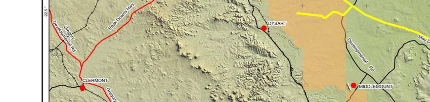

Section 21 Cumulative Impacts

21.1      Introduction

21.1.1 Objective
The objective of the cumulative impact assessment was to assess the potential for impacts from the
Red Hill Mining Lease (the project) to have compounding or synergistic interactions with similar
impacts from other projects, including projects proposed, under development or already in operation
within an envisaged sphere of influence of the project. The sphere of influence is considered to be
variable, based on each biophysical and social aspect considered during the compilation of this
environmental impact statement (EIS).

21.1.2 Overview
The impacts of projects are usually assessed by comparing the post-project situation to a pre-existing
baseline. Where projects can be considered in isolation this provides a good method of assessing a
project’s impact. However, in areas where baselines have already been affected by development, or
where future development will continue to add to the impacts in an area or region, it is appropriate to
consider the cumulative effects of development. This section describes the potential impacts of the
project that are cumulative.

There are three levels at which cumulative impacts may be relevant:

• EIS Study Area Localised Cumulative Impacts – These are the cumulative impacts that may result
  from multiple existing or proposed mining operations in the immediate vicinity of the project.
  Localised cumulative impacts include the cumulative effects from concurrent operations that are
  close enough to potentially cause additive effects on the environment or sensitive receivers. These
  typically include dust deposition, noise and vibration, groundwater drawdown, groundwater and
  surface water quality, and transport.
• Regional Cumulative impacts – Regional cumulative impacts include the project’s contribution to
  impacts that are caused by mining operations throughout the Bowen Basin region or at a
  catchment level. Each coal mining operation in itself may not represent a substantial impact at a
  regional level; however the cumulative effect on habitat availability and connectivity, downstream
  water quality, and the socio-economic characteristics of a region may warrant consideration.
• Global Cumulative Impacts – Global cumulative impacts are those that the project might contribute
  to at a global scale. The only impact from the project that has potentially global scale impacts is
  greenhouse gas (GHG) emissions as this relates to impacts on global concentrations of
  greenhouse gases in the atmosphere. The level of GHG emissions from the project, however,
  represents a very minor contribution at this scale (refer to Section 12).

                     Red Hill Mining Lease EIS │Section 21│Cumulative Impacts
                                              Page 21-1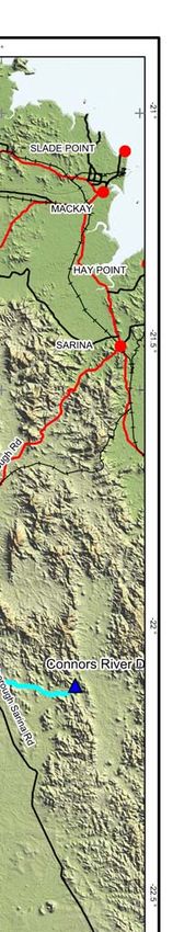
21.2      Relevant Projects

21.2.1 The project
The project comprises three elements as follows:

• an extension of three longwall panels (14, 15 and 16) of the existing Broadmeadow underground
  mine (BRM);
• a future incremental expansion option of the existing Goonyella Riverside Mine (GRM); and
• a future Red Hill Mine (RHM) underground expansion option located to the east of the GRB mine
  complex.
The Broadmeadow panel extensions will sustain existing operations and do not require the
construction of additional mining infrastructure and works will be carried out by the existing
Broadmeadow workforce. The impacts associated the Broadmeadow extensions are limited to the
surface impacts associated with the installation of gas drainage infrastructure and subsidence.

21.2.2 Other Relevant New or Developing Projects
The TOR requires the cumulative impact assessment to consider other nearby development projects.
The assessment is to include a summary of the project’s potential impacts with respect to both
geographic location and environmental values.

Relevant projects that have been considered include:

• projects within the envisaged sphere of influence of the project, as listed on the Department of
  State Development, Infrastructure and Planning (DSDIP) website that are undergoing assessment
  under the State Development and Public Works Organisation Act 1971 (SDPWO Act) for which an
  Initial Advice Statement (IAS) or an EIS are available; and
• projects within the envisaged sphere of influence of the project, which are listed on the website of
  the Department of Environment and Heritage Protection (EHP) that are undergoing assessment
  under the Environmental Protection Act 1994 (EP Act) for which an IAS or an EIS are available.
Projects currently undergoing assessment or having recently completed assessment under these
processes and included in the cumulative impact assessment for the project are listed in Table 21-1.

Table 21-1      Projects Considered in the Cumulative Impact Assessment

 Project -                                                        Relationship to Red Hill Mining Lease
                       Description                  EIS Status
Proponent                                                             Timing               Location
Eaglefield   Expansion of existing open-cut       EIS            May have            Abuts the northern
Coal Mine    mine from 5 to 10.2 mtpa.            assessment     overlapping         boundary of the
Expansion-   Construction workforce will be       report.        operational         Goonyella Riverside
Peabody      650 and the operational                             phases with the     Mining lease. Drains
             workforce will be 700.                              construction and    to Goonyella Creek
             Construction commenced in 2012                      operations of the   sub-catchment.
             with a 22 year mine life.                           GRM incremental
                                                                 expansion and the
             Accommodation will be at on-site                    RHM underground
             facilities.                                         expansion option.
             Coal will continue to be exported
             to Dalrymple Bay via existing rail
             infrastructure

                     Red Hill Mining Lease EIS │Section 21│Cumulative Impacts
                                                  Page 21-2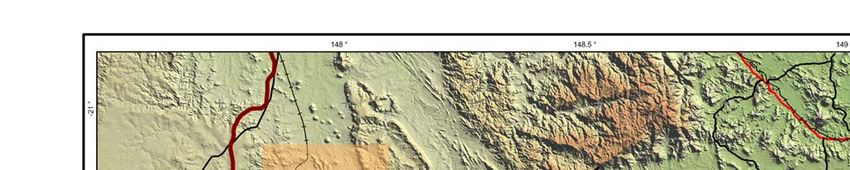
Project - Relationship to Red Hill Mining Lease
Description EIS Status
Proponent Timing Location
Ellensfield New underground coal mine to EIS May have 121 km to the west of
Coal Mine produce 5.5 mtpa. assessment overlapping the EIS study area
Project - Development also includes an on- report. operational May utilise the same
Vale site gas fired power station (8 to phases with the transport networks
20 megawatts). construction and Within the Isaac River
Construction workforce will be operations of the sub-catchment.
160 and the operational GRM incremental
workforce will be 280. expansion and the
RHM underground
Accommodation will be at expansion option.
Coppabella or Moranbah.
Timing for commencement
unknown
Grosvenor Greenfield underground mine to EIS process Likely to have 9 km to the south of
Coal Mine produce up to 5 mtpa. completed. overlapping the EIS study area.
Project – Construction and operation operational Land surface drains to
Anglo Coal workforces will both be phases with the the Isaac River.
approximately 500 persons. proposed project. May utilise the same
Construction commenced in 2012 transport networks
with full production by 2015. and will locate
Workforce accommodation 25% workers and
in Moranbah and 75% remote accommodation
workforce. facilities at Moranbah.
New Lenton Greenfield open-cut and IAS available. May have 15 km to the north-
Coal Mine underground mine to produce EIS lodgement overlapping east of the EIS study
Project – 5 mtpa. proposed operational area.
New Hope Construction workforce will be 2014. phases with the Within Isaac River sub
300 with an operational workforce proposed project. catchment.
of 200.
Construction commencement not
known.
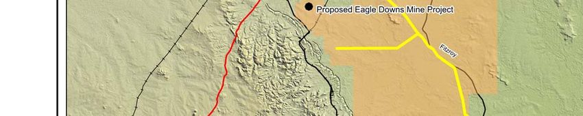
Eagle Greenfield underground mine to EIS process Likely to have 39 km to the south-
Downs Coal produce 7 mtpa. completed. overlapping east of the EIS study
Mine Construction workforce will be operational area.
Expansion - 360 and operational workforce phases with the May utilise the same
Aquila will be 570. project. transport networks
Workforce to be accommodated and may locate
at accommodation facilities in and workers at Moranbah.
around Moranbah. Within the Isaac River
Construction commenced in 2013 sub-catchment.
and first coal is expected in 2015
Caval Ridge Greenfield open-cut mine to EIS process May have 29 km to the south of
Coal Mine produce 5 mtpa. completed. overlapping the EIS study area.
Project - Construction workforce will be operational May utilise the same
BMA 1760 with an operational phases with the transport networks.
workforce of 500. construction and Within Isaac River
Remote workforce to be operations of the sub-catchment.
accommodated in single worker GRM incremental
facilities. expansion and the
RHM underground
Construction commenced in 2012 expansion.
with full production by 2014.
Red Hill Mining Lease EIS │Section 21│Cumulative Impacts
Page 21-3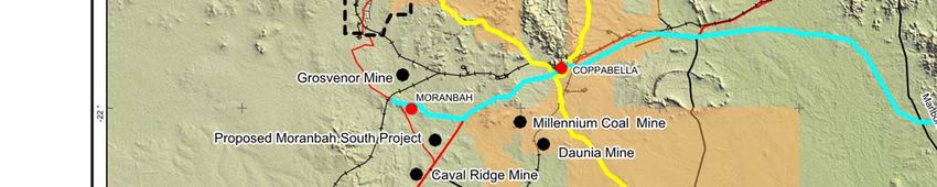
Project -                                                          Relationship to Red Hill Mining Lease
                         Description                 EIS Status
Proponent                                                               Timing               Location
Daunia Coal    Greenfield open-cut mine to         EIS process     Likely to have      36 km to the south-
Mine Project   produce 4.5 mtpa.                   completed.      overlapping         east of the EIS study
- BMA          Construction workforce of 1000                      operational         area.
               with an operational workforce of                    phases with the     May utilise the same
               450.                                                construction and    transport networks.
               Remote workforce to be                              operations of the   Within Isaac River
               accommodated in the Coppabella                      GRM incremental     sub-catchment.
               Accommodation Village.                              expansion and the
                                                                   RHM underground
               Construction commenced in 2009                      expansion option.
               with full production achieved in
               2013.
Millennium     Expansion of an existing open-cut   EIS             May have            30 km to the south-
Coal Mine -    coal mine from 2 to 5.5 mtpa.       completed.      overlapping         east of the EIS study
Peabody        Construction workforce of 627                       operational         area.
               with an additional operational                      phases with the     May utilise the same
               workforce of 160.                                   construction and    transport networks.
               Accommodation for both                              operations of the   Within Isaac River
               construction and operational                        GRM incremental     sub-catchment.
               workforces to be at the                             expansion and the
               Coppabella Village.                                 RHM underground
                                                                   expansion option.
               Construction commenced in 2012
               with full production by 2015.
Moranbah       Greenfield underground mine to      EIS lodged,     May have            28 km to the south of
South          produce 18 mtpa.                    public notice   overlapping         the EIS study area
Project –      Construction commencement not       period          construction and    May utilise the same
Anglo Coal     known                               completed.      operational         transport networks.
and Exxaro     Mine infrastructure proposed                        phases with the     Within Isaac River
Australia      adjacent to the Moranbah airport.                   GRM incremental     sub-catchment.
Pty Ltd.                                                           expansion and the
                                                                   RHM underground
                                                                   expansion option.
Connors        Water supply dam on the             EIS             May have            Pipeline passes within
River Dam      Connors River and a water supply    completed.      overlapping         13 km to the south of
and Pipeline   pipeline from the dam to                            construction and    the EIS study area.
– Sunwater     Moranbah to service coal mines                      operation phases    Dam is located in the
               and communities in the Bowen                        with the project.   Connors River
               Basin.                                              Dam construction    subcatchment,
               Construction workforce will be                      will be remote      approximately 10 km
               250 for the dam and 300 for the                     from the proposed   south of the EIS study
               pipeline. There will be                             project with        area.
               accommodation at an on-site                         minimal impact.
               construction camp.                                  Pipeline
               Project has been deferred.                          construction will
                                                                   be short term.
Goonyella      70 km long stretch of new rail,     Complete.       Operational         Southern end is
to Abbot       linking the Goonyella system to                     overlap with the    adjacent to GRM and
Point Rail     the Newlands system.                                construction and    0.7 km from the EIS
Expansion      Construction commenced in                           operations of the   study area.
Project –      2011, and was completed in                          GRM incremental
Aurizon        2012.                                               expansion and the
                                                                   RHM underground
                                                                   expansion option.

                       Red Hill Mining Lease EIS │Section 21│Cumulative Impacts
                                                   Page 21-4
Project - Relationship to Red Hill Mining Lease
Description EIS Status
Proponent Timing Location
Bowen Gas Construction of an approximate EIS May have Runs to the east of
Pipeline – 580 km of pipelines and completed. overlapping the EIS study area at
Arrow associated infrastructure, which construction and a distance of 3 km at
Energy will convey coal seam gas (CSG). operational phase its closest point.
Construction commencement not with the GRM
known incremental
Construction workforce of expansion and the
approximately 700, RHM underground
commissioning and expansion option.
decommissioning workforce of Operational
10, and operations workforce of impacts not
15. significant at a
local or regional
level.
Bowen Gas Development of approximately EIS lodged Operational CSG infrastructure to
project – 7,000 CSG production wells over and impacts will be extend north to south
Arrow an approximate 35 to 40 year life supplementary managed as part from Glenden to
Energy Much of the gas produced by the EIS being of a co- Blackwater covering
Bowen Gas Project will be piped prepared. development the majority of
to the proposed Curtis Island agreement with MLA70421.
LNG Plant. Arrow Energy.
Construction commencement not
known.
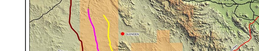
The locations of these mining projects considered in the cumulative assessment are shown on Figure
21-1.
21.2.3 Existing Developments
In most cases, impacts of existing developments such as operational mining activities have already
been accounted for in terms of baseline data collection. For example, background noise
measurements account for noise levels from existing activities that are audible at receptors identified
for the Red Hill project. Similarly, the conservation status of flora, fauna and vegetation communities
is based on known extents of habitats or populations and hence, takes into account clearing that has
occurred to date. For social and socio-economic issues, assessment of impacts is based on potential
changes when compared to current baseline conditions, which have already been influenced by
existing developments and operations
Contribution of existing activities to impacts is, therefore, already accounted for in the impact
assessment and is not considered further in this cumulative impact assessment.
Red Hill Mining Lease EIS │Section 21│Cumulative Impacts
Page 21-5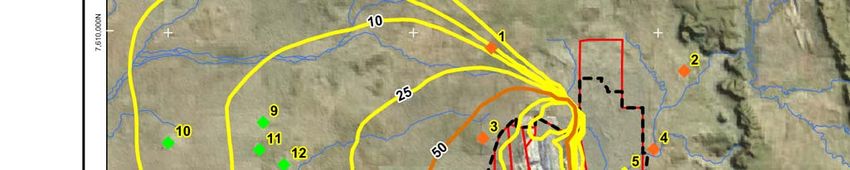
21.3       Cumulative Impacts

21.3.1 Land Resources

21.3.1.1 Method of Assessing Land Resource Impacts
This section of the cumulative impact assessment considers potential impacts on land resources from
the project compounded by nearby development proposals, as listed in Section 21.2. Land resource
cumulative impacts have been measured using the following indicators:
• the dominant current land use within each project area; and
• the presence of good quality agricultural land (GQAL) and potential strategic cropping land (SCL)
  associated with each project.
It should be noted that data used to assess each criteria were derived from available sources and may
be subject to change. The assessment of GQAL and SCL relies on data provided in respective EIS
documents and desktop interpretations of local and state government data and was not validated by
further field work by the EIS study team.

21.3.1.2 Cumulative Land Resource Measurement
The operation of the project will impact on existing cattle grazing operations, and disturb minor
tributaries of the Isaac River within the project footprint. The future RHM is anticipated to operate for a
period of 20 to 25 years and with infrastructure associated with the GRM incremental expansion option
will disturb an approximate 3,967 hectares. Further details of the impacts of the GRM incremental
expansion and RHM expansion option on land resources are contained within Section 5.

An assessment has been undertaken to obtain estimates of the area to be altered through mining
activities within the listed nearby projects. The results of this assessment are tabulated Table 21-2.

Table 21-2         Land Resource Impacts
    Project         Estimated   Life of             GQAL                SCL       Existing      Proposed
                      Area      Project                                           Land Use        post
                                                                                                 mining
                                                                                                land use
Red Hill Mining    3,967 ha     20-25      Present:                  No (none    Grazing,       Grazing
Lease Project                   years      •   Class B               within      mining
(underground                                                         impacted
                                           •   Class C1
footprints and                                                       areas)
                                           •   Class C2
surface
infrastructure)                            •   Class C3
                                           •   Class D
Eaglefield Coal    3,515 ha     22 years   Present                   No          Grazing        Grazing
Mine Expansion                             •   Class A
(open-cut &                                •   Class B
underground)
                                           •   Class C1
Ellensfield Coal   3,388 ha     20 years   Present                   No          Grazing        Grazing
Mine Project                               •   2,396 ha (grazing
(underground)                                  only – assumed C1)

                       Red Hill Mining Lease EIS │Section 21│Cumulative Impacts
                                                Page 21-7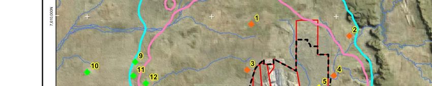
Project         Estimated     Life of             GQAL                SCL        Existing     Proposed
                      Area        Project                                            Land Use       post
                                                                                                   mining
                                                                                                  land use
Grosvenor Coal      9,000 ha      24 years   Present                    No          Grazing       Grazing
Mine Project                                 •   Class C
(underground)
New Lenton          1,205 ha      Unknown    Present                    Potential   Grazing       Grazing
Coal Mine                                    •   Class n/a              SCL
Project
(open cut &
underground)
Eagle Downs         4,550 ha      54 years   Present                    No          Grazing       Grazing
Coal Mine                                    Pre-mining:
Expansion
                                             •   Class B – 334.5 ha
(underground)
                                             •   Class C – 3,869.2 ha
                                             •   Class D – 352.7 ha
                                             Post-mining:
                                             •   Class B – 154 ha
                                             •   Class C – 3,328.2 ha
                                             •   Class D – 774.2 ha
Caval Ridge         6,440 ha      30 years   Present                    Potential   Grazing/      Grazing
Coal Mine                                    •    Class A – 245 ha      SCL         Mining and
Project                                                                             Commercial
                                             •    Class C1 – 3,454 ha
(open-cut)                                                                          (airport)
                                             GQAL will not be
                                             disturbed by mining
                                             activities.
Daunia Coal         2,000 ha      21 years   Present                    Potential   Grazing       Grazing
Mine Project                                 Impact Area:               SCL
(open-cut)                                   •   Class A – 160 ha
                                             •   Class B – 80 ha
                                             •   Class C – 1,530 ha
Millennium Coal     966 ha        16 years   Present                    No          Mining /      Grazing
Mine Project                                 •   Class n/a (likely                  Grazing
(open-cut)                                       Class A, Class B                   (expansion
                                                 and Class C1)                      of existing
                                                                                    mine)
Moranbah            17,550 ha     30 years   Present                    Potential   Grazing       Grazing
South Project                                •   Class n/a              SCL
(underground)
Connors River       5,850 ha      100+       Present                    Potential   Grazing       Grazing
Dam and             dam + 133     years      •   Class n/a (likely      SCL
Pipeline (project   km pipeline                  Class A, Class B
deferred)                                        and Class C1)
Goonyella to        69 km rail    100+       Present                    Potential   Grazing       Grazing
Abbot Point Rail    Corridor      years      •   Class n/a (likely      SCL
Expansion                                        Class A, Class B
Project                                          and Class C1)
(Aurizon)
Bowen Gas           580 km        Unknown    Present                    Potential   Grazing       Grazing
Pipeline            pipeline                 •   Class A                SCL
                                             •   Class B
                                             •   Class C1

                        Red Hill Mining Lease EIS │Section 21│Cumulative Impacts
                                                  Page 21-8
Project Estimated Life of GQAL SCL Existing Proposed
Area Project Land Use post
mining
land use
Bowen Gas Study area: 35 years Present Potential Grazing/ Grazing
2
Project 10,000 km • Class A SCL Cropping
• Class B
• Class C1
Class: arable (A), limited arable (B), pastoral (C) and non-agricultural (D).
21.3.1.3 Assessment
The proposed mining and infrastructure projects listed in Table 21-2 will all directly impact on land of
agricultural value. GQAL appears to be present across the majority of project areas. The areas of
Class A and Class B are limited. The majority of land is Class C, which is suitable for grazing
activities. Small areas of SCL have been identified on some of the sites through Queensland
Government mapping of SCL management areas; however, it is not known if validation has been
undertaken for any of these areas.
The mining projects have an expected life of mine in the order of 20 to 50 years with the planned post
mining land use being return to agriculture in the case of each mine. This requirement to rehabilitate
is placed on mining through the environmental authority (mining activities) issued under the
Queensland Environment Protection (EP) Act, and mining proponents are required to lodge financial
assurance against achievement of rehabilitation requirements. However, some degradation of
agricultural productivity can be expected particularly for open cut projects.
The infrastructure projects are likely to be present for longer periods, with the potential Connors River
Dam (currently deferred) effectively permanent. The proposed rail and gas projects have limited
impact on agricultural productivity provided that access and stock movements are not overly restricted.
In the context of the area of agricultural land that may be affected, the projects range in size from
about 1,205 hectares to approximately 17,500 hectares.
The cumulative area of these proposed projects represents a relatively small loss of land resources at
a regional or state level, given the widespread availability of similar agricultural land resources across
the region, agricultural productivity is not expected to be significantly reduced or disrupted.
Further, the more significant agricultural lands within the Bowen Basin are large tracts of arable
rainfed broad acre cropping situated on the flood plains of the Isaac, Mackenzie, and Comet rivers.
These areas are located to the south of the considered mining operations within the northern Bowen
Basin.
Strategic cropping land is limited in the considered area. Cropping is present but is confined to areas
of more fertile soils and where the use of agricultural machinery is not constrained by difficult
topography.
The need to balance agricultural production with mining activities, and the economic benefits of mining
are identified in State government policies and regional statutory plans. Alternative locations for
mining activities are not generally available as location is driven by the presence of a viable resource.
Principle 4.3.1 of the Mackay, Isaac and Whitsunday Regional Plan provides for ‘Mineral, petroleum
and extractive resources to be managed for current and future use, and their extraction, processing,
transport and downstream value-adding continue to contribute to the economy’.
Red Hill Mining Lease EIS │Section 21│Cumulative Impacts
Page 21-9Overall, while some cumulative loss of agricultural land can be expected, this loss is balanced by
economic benefits from mining activities, and is not likely to significantly reduce overall agricultural
productivity when considered at a regional or state level.
21.3.2 Scenic Amenity
21.3.2.1 Regional Cumulative Impacts
At the regional scale the overburden landforms typically associated with current and previous open cut
mining are the most significant non-natural visual elements in the landscape. However, the proposed
underground RHM will not result in the creation of any new overburden landforms and therefore will
not contribute to the cumulative regional impacts associated with the overburden landforms.
The project will be utilising existing services; power, water, and roads, thus potential cumulative
impacts at a regional scale will be negligible.
21.3.2.2 EIS Study Area Localised Cumulative Impacts
The scenic amenity assessment has determined that the potential visual impacts of the proposed
mining and infrastructure components of the project will be low to negligible. The above ground
infrastructure elements associated with the GRM incremental expansion will be similar in visual
character and scale to the existing infrastructure associated with current mining at GRM, BRM, and
North Goonyella Mine. The infrastructure elements will generally not be visible from Red Hill Road,
which is the only public road in the vicinity of the project. Consequently the contribution of the above
ground infrastructure to the cumulative impacts of existing mining operations in the vicinity of the site
will be very low. The construction of a proposed flood levee around the proposed Red Hill MIA will
have only localised visual impact and will not contribute to altering the broader landscape. Further
discussion of the proposed levee design and visual impact is provided in Section 5.2.
Vegetation clearing and installation of the proposed incidental gas management infrastructure will
contribute to the cumulative impact of other vegetation clearing in the vicinity of the project. However,
the relative limited extent of (additional) clearing and the proposed revegetation program will result in
re-establishing the grassland and riparian vegetation characteristic of the existing (modified for
agriculture) landscape in the area. The longer term cumulative visual impacts are therefore expected
to be minimal.
21.3.3 Surface Water Resources
21.3.3.1 Water Quality
The project is located just inside the catchment boundary for the Isaac River, which is a major tributary
within the Fitzroy basin. The Fitzroy basin is the largest catchment in Queensland draining into the
Pacific Ocean and also the largest catchment that drains to the Great Barrier Reef, although it does
not contribute significant freshwater flows to the coastal environment when compared to river systems
further north.
Red Hill Mining Lease EIS │Section 21│Cumulative Impacts
Page 21-10In 2008, the Queensland Government undertook an investigation into the cumulative effects of coal
mining in the Fitzroy River basin on water quality (EPA 2009). The investigation found that:
• There were inconsistencies in discharge quality limits and operating requirements for coal mine
water discharges as imposed through environmental authorities.
• In some cases, discharge limits and operating conditions of coal mines were not adequately
protecting downstream environmental values.
These conclusions led to a number of inter-related actions by Queensland Government and other
stakeholders:
• Water quality objectives were developed for the Fitzroy Basin and added to Schedule 1 of the
Environmental Protection (Water) Policy 2009 (EPP (Water)) in October 2011.
• Model water conditions were developed for coal mines in the Fitzroy basin (DERM February 2012).
These model water conditions are designed to manage water discharges to meet the water quality
objectives set out in the EPP (Water) and to provide consistency between mining operations in the
Fitzroy basin.
• Environmental authorities for a number of mining operations were amended to introduce conditions
consistent with the model water conditions.
• A number of mining operations entered into Transitional Environmental Programs (TEP) under the
EP Act. These TEPs were focussed on actions that would allow mines to achieve compliance with
new environmental authority conditions and upgrade operating conditions.
With these measures in place, a strong strategic and policy framework is now in place for
management of cumulative water quality impacts from mining activities. This framework allows for
management of individual mining activities in such a way that overarching water quality objectives can
be achieved.
Mine water from the proposed Red Hill Mine and Broadmeadow extension will be managed through
the existing Goonyella Riverside and Broadmeadow mining complex water management system as
this allows water to be reused in coal handling and preparation. The environmental authority
EPML00853413 (formerly MIN 100921609) for the GRB mine was amended in October 2011 to bring
it into line with the model water conditions, with discharge conditions and in-stream trigger levels
aligned with water quality objectives in the EPP (Water). Using a mine water balance model, an
analysis has been undertaken of the effect of water from the proposed RHM on the ability of GRB
mine to maintain compliance with environmental authority conditions (Section 7.3.4). This analysis
indicates that the addition of mine water from the RHM makes no difference to the compliance profile
for GRB and is negligible in terms of salt load to the Isaac River.
While the EPA cumulative impact assessment of mining in the Fitzroy Basin focussed on salinity as
the key water quality issue related to mining activities, surface disturbance associated with mining
activities can result in erosion and increased sediment levels in surface waters. The Great Barrier
Reef outlook report also identified that the Fitzroy Basin contributed one of the highest sediment loads
to the reef, largely attributing sediment loads to use of land for agricultural activities (GBRMPA 2009).
Water quality data presented in Section 7.2.6 indicates that suspended solids and turbidity in the
upper Isaac River and local tributaries are in excess of water quality objectives and hence, cumulative
assessments must consider additional sediment inputs.
Red Hill Mining Lease EIS │Section 21│Cumulative Impacts
Page 21-11The Queensland Government commissioned an assessment of mine affected water releases in the
Fitzroy River basin during the 2012–2013 wet season. The report, prepared by consultants Gilbert
and Sutherland, concluded that the Fitzroy as a whole is not currently ‘at capacity’ in terms of salt load
at a catchment or sub-catchment scale.
The water quality assessment undertaken for the project has identified that sediment inputs can be
controlled through drainage, erosion and sediment control measures. Depressions created by
subsidence will also tend to trap sediment until the depressions are in-filled (a matter of decades) and
while this will mitigate effects of any erosion across the mine footprint, it is unlikely to create a
significant reduction in sediment load in the lower Isaac River and Fitzroy system. On this basis, the
proposed project is not expected to make any significant contribution to cumulative sediment loads in
the Fitzroy River Basin.
Given that the GRB mine water releases are being managed within an overarching strategic
framework for management of cumulative impacts of mining activities, the proposed management
approach for mine water from the project is expected to have negligible cumulative impact on surface
water quality and associated environmental values.
21.3.3.2 Subsidence
In 2009, the then DERM, BMA and Anglo Coal undertook a cumulative impact assessment of the
combined effects of subsidence of the Broadmeadow underground mine (BMA) and Moranbah North
mine (AAMC) (Alluvium 2009).
The Isaac River Cumulative Impact Assessment (IRCIA) developed and quantified impacts from
subsidence and associated geomorphic response of the Isaac River across all the existing and
proposed underground mine plans that were planned to extend beneath the Isaac River as they were
known in 2007. While the current mine plan for the future RHM includes a different configuration of
longwall panels, and potentially a greater depth of subsidence, the overall findings of the IRCIA remain
relevant. The length of time within which subsidence troughs along the Isaac River can be expected
to fill in will potentially increase from the IRCIA predictions because of the increased subsidence
depth, however there is still a moderate probability that these troughs will infill during the life of the
mine. Geomorphic effects are not significantly different.
The IRCIA identified that while there is potential for impacts on the Isaac River as a result of mine
related subsidence, none were determined to be significant in terms of instigating long term large
scale geomorphological change. Subsidence voids in the river channel based on the then current
mine plans when considered on a reach scale were predicted to have close to 50 per cent or greater
probability of infilling during the period of mining. Overall, subsidence voids were predicted to be
infilled within 20 years after the cessation of mining on the Isaac River unless there is a substantial
reduction of sediment inputs from the Isaac River catchment. Within the mining period however, risks
were identified to bed and bank stability along the 28 kilometre reach considered, such as potential for
river bed deepening of up to 1.8 m and subsequent widening through bank erosion. Such impacts are
presently being managed for existing mining operations at the local scale with soft engineering
solutions such as timber pile fields and vegetation being implemented at BRM and Moranbah North
mine.
BMA and Anglo Coal are currently engaging with Queensland Government agencies in relation to
updating the IRCIA to take into account current mine plans for underground mines. This will include
the current mine footprint for BRM and the future RHM.
Red Hill Mining Lease EIS │Section 21│Cumulative Impacts
Page 21-1221.3.3.3 Flooding
A flooding assessment of the project was undertaken (Section 7.3.3). The study took into account
any existing structures that may affect flood behaviour as well as structures proposed for the project.
There are no known projects in the planning or development phase that might result in additional
structures on the floodplain in the vicinity of the project. Cumulative impacts on flooding are not
expected to lead to any adverse impacts on human populations, property or other environmental or
social values.
21.3.3.4 Surface Water Flows
The major influence on water flows in the Isaac River is the Burton Dam, located upstream of the Red
Hill Mining Lease. The Connors River Dam on the Connors River will also influence flows in the
McKenzie River below the confluence of the Isaac River once it is operational. Both projects have
been addressed in water resource planning as documented through the Water Resource (Fitzroy
Basin) Plan 2011. There are no other major storages on the Isaac River. In Queensland, the water
resource planning process focussed on balancing water extraction and use with protection of
ecosystems and takes into account cumulative impacts from major water storages and extraction.
The project does not require any additional raw water allocations and therefore does not contribute to
cumulative impacts in relation to extraction of surface water resources.
Depressions created by subsidence will trap overland flow and in-channel stream flows until such time
as sediment carried by these flows in-fills the depressions, which is estimated to occur over a matter of
decades for the Isaac River. For the 12 Mile Gully tributary, sediment load is lower and permanent
ponds are expected to arise. These will retard flows in 12 Mile Gully and discharges from 12 Mile
Gully to the Isaac River. Assessment has indicated that there will be no measurable change in water
resources when considered against flow objectives established in the Water Resource (Fitzroy Basin)
Plan 2011; however; some localised effects may occur. Mitigation measures have been proposed to
lower the water levels in subsidence troughs by creating overflow channels, if necessary, with the
requirement for this to be determined post-subsidence. In any case, the proportion of water that may
be retained is negligible when considered against environmental flow objectives in the Isaac River and
is unlikely to make any measurable difference at downstream nodes. Given that mitigation measures
are available to address the reduction in flow associated with containment of water in subsidence
troughs, cumulative impacts on flows in the Isaac River and downstream rivers are not expected.
21.3.4 Groundwater
Cumulative impacts to groundwater resources have been assessed considering other coal mining
operations in the immediate vicinity of the project. Predictive groundwater modelling was conducted
for the project but did not include consideration of future mine operations. The project will increase
impacts on the available groundwater resources within the Bowen Basin groundwater study area by
increasing groundwater extraction via mine dewatering and incidental mine gas drainage.
Groundwater in the area is limited in both quality and quantity and aquifers are compartmentalised by
regional faults. This limits potential for regional-scale drawdown effects and also limits the extent to
which existing users may be impacted by cumulative impacts.
Dewatering activities from the coal mining projects proximal to the project will have varying impacts on
regional groundwater levels depending on mine plans, schedule, and IMG management requirements.
Red Hill Mining Lease EIS │Section 21│Cumulative Impacts
Page 21-13Due to the low permeability of the Moranbah Coal Measure coal seam aquifers, marked alterations to
groundwater levels (drawdown) are restricted proximal to the proposed RHM footprint with drawdown
impacts expected to be limited to a zone of around four kilometres from the proposed mine. Based on
the uniformity of the geology and that all coal mining proximal to the project target the same coal
measures, the extent of drawdown around existing mines is considered to be on a similar scale.
The impact of mine dewatering around the projects is dependent on groundwater heads (gradient) and
permeability.
The impact of additional mines, adjacent and along strike, where predicted drawdown cones overlap
will result in an increase in the drawdown in groundwater level. The extent of the drawdown cones is
governed by the hydraulic conductivity.
Dewatering impacts (drawdown cones) are predicted to elongate north and south, within the more
permeable units (the coal seam aquifers). The cumulative impact of adding the additional mine
dewatering will result in deeper drawdown where drawdown cones overlap and further elongation
along strike.
The cumulative impacts to groundwater resulting from the project and the existing mining operations in
the vicinity (GRM, BRM, Moranbah North, and North Goonyella Mine) were assessed based on the
conceptualisation of multiple mines, as discussed above. The future RHM is located down-dip of GRM
and down-dip and along strike of BRM. Moranbah North and North Goonyella Mine are located south
and north respectively along strike in the Moranbah Coal Measures relative to the project. The
cumulative impact of the existing mines will be to superimpose the drawdown of each mine along
strike such that the Moranbah Coal Measures will be dewatered between the mines. The additional
impact of the future RHM will be to increase drawdown in the Moranbah Coal Measures east of GRM
and to the north east of BRM. This additional drawdown (five metre drawdown extent in the target
seam) will extend to approximately four kilometres from the RHM underground footprint,
encompassing part of the GRM and BRM mines to the west and southwest. The predicted drawdown
will not impact on any private bores and no groundwater dependent species are located within the EIS
study area.
After mining is completed, the groundwater system will re-adjust to the new aquifer conditions created
through mining (i.e. alteration due to goaf). Groundwater levels and piezometeric pressures within the
regional aquifers will, over time, attain a new equilibrium level. The rate of groundwater level recovery
will be slowed due to the ongoing mining operations at GRM.
As drawdown of five metres below steady state conditions (drawdown identified to have marked
impacts on bore yields) is only predicted to extend some four kilometres from the RHM footprint, coal
mines further along strike within the Moranbah Coal Measures (Grosvenor, Caval Ridge, and Eagle
Downs) are outside of the RHM impact area. Other coal mines further afield from the EIS study area
(Ellensfield, New Lenton, Daunia and Millenium), are well outside the RHM impact area and are
separated by large fault systems. The faults, which displace units and compartmentalise aquifers, limit
the extent of mine dewatering and depressurisation groundwater impacts.
Possible CSG projects could occur within the project impact zone created by dewatering and
depressurisation at RHM. The additional depressurisation created by CSG operations would, similar
to mine dewatering, create deeper drawdown where drawdown cones overlap and further elongation
along strike. Drawdown in the hanging wall down dip of the operations will be limited towards the east
due to the fault systems, which compartmentalise the coal resources. Groundwater use is limited to a
Red Hill Mining Lease EIS │Section 21│Cumulative Impacts
Page 21-14small number of private bores located to the east of the EIS study area. It is not anticipated that the
drawdown will impact upon these bores, however make good arrangements would need to be made
with these landowners if there is predicted to be an impact due to CSG operations.
21.3.5 Terrestrial Ecology
The project is located within the northern Bowen Basin subregion of the Brigalow Belt bioregion. The
Brigalow Belt bioregion has been historically altered for agricultural activities. In addition, forestry,
road development, mining and pipeline easements have further reduced and fragmented the area of
remnant vegetation present. The current remnant vegetation in the bioregion is estimated at 42 per
cent of the pre-clearing amount. This is lower than the estimated remnant vegetation extent within the
subregion (57 per cent).
Some of the identified projects (Table 21–1) may have overlapping construction phases with the GRM
incremental expansion and the RHM underground expansion option. The published impacts on
remnant vegetation of the Eaglefield Coal Mine Expansion, Ellensfield Coal Mine Project, Grosvenor
Coal Mine Project, Eagle Downs Coal Mine Expansion, Caval Ridge Coal Mine Project, Daunia Coal
Mine Project, and Millennium Coal Mine combine to a total of approximately 3,500 hectares of
remnant vegetation to be cleared. This represents 0.4 per cent of remnant vegetation within the
subregion. This estimate includes approximately 940 hectares of Environment Protection and
Biodiversity Conservation Act 1999 (EPBC Act) threatened ecological communities (TECs),
endangered regional ecosystems (REs) or of concern REs. Given the similarity in environment of the
other mining projects considered in the cumulative assessment, and the proximity of most of these
projects to each other, it is expected that the threatened ecosystems impacted by their development
will be similar to those impacted by the proposed project.
Cumulatively, direct and indirect impacts on native vegetation from mining projects will result in an
increased overall loss or modification of remnant vegetation, including TECs and endangered and of
concern REs, as well as habitat for species of conservation significance. In addition to further
reduction in extent of these vegetation communities and habitat types, mining and linear infrastructure
projects can block connectivity between major areas of habitat. A reduction in habitat connectivity
may restrict opportunities for fauna to successfully seek food and water, breed and colonise new
territories. Fragmentation of native vegetation also affects genetic diversity as breeding populations of
animals cannot interact, and distribution of seeds and other plant propagules can also be restricted.
The RHM underground mine footprint extends under the Isaac River, as does the existing BMA
Broadmeadow Mine and Anglo Coal Moranbah North Mine which are located downstream of the
project, also along the Isaac River. The Isaac River is identified as an area of State significance as a
wildlife corridor, although continuity of the corridor is reduced through the Broadmeadow Mine area as
the Isaac River in this location was diverted in the early 1980s to allow for open cut mining to the west.
Mitigation measures and rehabilitation plans have been proposed for the proposed Red Hill Mine to
maintain and enhance this corridor during the mining activity which will limit further cumulative impacts
on this corridor.
While the emphasis for projects is on minimising clearing or modification of native vegetation and
habitat, for resource projects and linear infrastructure projects, avoidance of ecological values is not
generally possible. Given this, the key mechanism in place for addressing cumulative impacts on
native vegetation and habitat is the requirement for provision of offsets. Requirements for biodiversity
offsets tend to increase the incentive for individual projects to minimise impacts on key biodiversity
Red Hill Mining Lease EIS │Section 21│Cumulative Impacts
Page 21-15values, as well as providing for maintenance of the areal extent of native vegetation communities and
habitats in the medium to long term.
Under Queensland legislation, mining projects must offset impacts on State significant biodiversity
values in accordance with the Queensland Biodiversity Offsets Policy. State significant biodiversity
values required to be offset include:
• various categories of regional ecosystems including endangered and of concern REs, high value
regrowth and threshold ecosystems;
• essential habitat for listed species of conservation significance;
• wetlands and watercourses, including riparian zones; and
• connectivity.
While provision of offsets by various projects will preserve the areal extent of remnant vegetation
communities and habitats in the medium to long term, offset areas can take some time to reach levels
of equivalent ecological function of the vegetation communities and habitats to be affected by
development. Hence there may be a time lag in terms of replacement of habitat for animals of
conservation significance. However, for mining projects, which represent the bulk of vegetation
clearing in the region, clearing takes place progressively over the life of the mine and offset proposals
are either provided up-front or progressively. This minimises the effect of this time lag. Apart from
direct and indirect effects of vegetation and habitat clearing, there may be cumulative impacts arising
from impacts such as increased levels of weeds and pests and additive effects due to injury or
mortality of animals from vehicle movements. Mitigation measures are available to address these
sorts of impacts at a project level and further mitigation to address these impacts on a cumulative
basis is not required.
21.3.6 Aquatic Ecology
The impacts of the proposed development to aquatic ecology are discussed in detail in Section 10 of
the EIS. Aquatic ecosystem studies undertaken for the project and for BMA’s GRB mine complex
operations (BMA 2011) indicate that aquatic ecosystems in the vicinity of the EIS study area are
slightly to moderately degraded and in some areas, heavily degraded. All natural drainage lines within
the EIS study area and surrounds are ephemeral. The streams are characterised by unstable
sediments, have limited aquatic vegetation, and few snags. No aquatic fauna species of special
conservation significance were recorded during current or previous surveys. The ground survey of
aquatic fauna assemblages in 2011 indicates taxa present are resilient and opportunistic species.
Many of the macroinvertebrates are highly mobile and readily inhabit newly inundated waters. Fish
exhibit breeding strategies associated with intermittent streams where populations flourish only during
favourable conditions.
Given the similarity in land use and stream characteristics across the subcatchment, it is expected that
this is also the case in proximity to other projects identified. The Isaac River catchment, within the
Bowen Basin, is overlain by either mining leases, mining claims, or exploration permits (coal,
petroleum and mineral).
Key impacts identified are:
• Impacts on aquatic ecosystems from multiple crossings of streams during installation of incidental
mine gas management infrastructure.
Red Hill Mining Lease EIS │Section 21│Cumulative Impacts
Page 21-16• Impacts on water quality and consequent effects on aquatic ecosystems from release of sediments
to surface waters. Release of sediments may occur as a result of mobilisation of soils from
disturbed areas by overland flows as well as scouring at locations on watercourses disturbed by
installation of infrastructure.
• Impacts on aquatic ecosystems if a large spill of hydrocarbons occurred in an area that drained to
surface waters.
• Modifications to aquatic ecosystems within the underground footprint due to subsidence.
Other underground mining projects would have similar impacts on aquatic ecosystems, whilst open cut
mining operations would not cause subsidence but may require watercourse diversion. Linear
infrastructure projects would potentially cause sediment mobilisation and scouring of watercourses
during the construction stage, with impacts diminishing during operations. Linear infrastructure
projects and linear infrastructure within mining leases might also cause changes in fish passage
depending on how infrastructure crossings of streams are designed and constructed.
Cumulatively, the most significant potential for degradation of aquatic ecosystems would likely arise
from multiple crossings of streams by linear infrastructure as well as diversions of streams that are
required for some mining projects (the proposed project does not require diversion). While
subsidence modifies instream habitats, the nature of streams in the region is such that these
modifications will tend to maintain current habitat conditions or potentially enhance habitat through the
creation of pools.
Management measures have been identified for the project to avoid and minimise impacts on aquatic
ecosystem values. These measures include adherence to State government policies and guidelines
intended to protect fish habitat, fish passage and bed and banks of stream channels. State
government policy and guidelines are also in place in relation to stream diversions. Design,
construction and operation in accordance with these policies and guidelines by all mining and
infrastructure projects will ensure that further degradation of aquatic ecosystems will be minimal.
21.3.7 Air Quality
While the proposed Red Hill Mine is predicted to make only a very minor contribution to dust
emissions, cumulative impacts are considered in relation to adjacent mining activities operated by
BMA and others.
The Peabody Energy North Goonyella underground mine and the Eaglefield open-cut mine are
located to the north of GRB mine complex. Adjacent to the southern boundary of the GRB mine
complex is Anglo Coal’s Moranbah North underground mine. Anglo Coal has received Queensland
government approval to develop the Grosvenor underground mine to the south of its Moranbah North
operations with both mines utilising a common CHPP located at Moranbah North.
In order to assess the potential for cumulative impacts from BMA and non-BMA mining operations,
dispersion modelling was undertaken. Information pertaining to operations not controlled by BMA was
sourced from publically available information. Details of the emissions for each of the facilities are
provided in Appendix L. For non-BMA operations, data was obtained from published EIS for each of
the projects and hence, may not reflect actual dust emissions.
Red Hill Mining Lease EIS │Section 21│Cumulative Impacts
Page 21-17The cumulative impact assessment has explicitly included predicted emissions of dust from the
following:
• GRB mine complex (BMA);
• the project (BMA);
• Eaglefield Mine (Peabody Energy); and
• Moranbah North Mine and Grosvenor underground mine (Anglo Coal).
21.3.7.1 Background Creep
A summary of the background creep due to the cumulative impact of emissions from both BMA and
non-BMA mining operations, as well as the project is presented in Table 21-3. A contour plot is
presented in Figure 21-2.
A comparison with results presented in Table 21-3 and Figure 21-2 for the GRB mine complex only,
highlights the impact of open-cut mining activities associated with the proposed Eaglefield Expansion
Project on receptors located in the north region of the local airshed.
21.3.7.2 Cumulative Future Air Quality Environment
A summary of the receptor locations at which exceedences of the relevant EPP (Air) objectives are
predicted when cumulative impacts are considered is presented in Table 21-4. Additional results are
presented in Appendix L.
A plot showing predicted impacts of cumulative emissions and comparing the EPP (Air) objective of 50
3
µg/m for the 24-hour average concentration of PM10 for both the future mining scenarios and the
cumulative future mining scenarios is presented in Figure 21-3. The influence of dust emission
3
sources associated with the Eaglefield Expansion Project is evident by the extension of the 50 µg/m
contour northward of its future mining scenario location.
Modelled dust emissions from the project make a very minor contribution to overall dust levels.
Existing and proposed underground mining activities to the south of the GRB mine complex
associated with the MNM and Grosvenor mine are predicted to have a minor impact.
Red Hill Mining Lease EIS │Section 21│Cumulative Impacts
Page 21-18Table 21-3 Background Creep of PM10 for the Cumulative Future Mining Scenario Based on the
70th Percentile 24-Hour Average Concentration of PM10
Scenario Scenario Scenario Scenario
Receptor
FY2015 FY2030 FY2040 FY2050
R1 - Denham Park 0 0 0 0
R2 - Burton Downs 0 0 0 0
R3 - Lapunyah 65.8 55.5 41.8 39
R4 - Red Hill 0 0 0 0
R5 - Riverside Homestead 0 0 0 0
R6 - Broadmeadow Cottage 2 6.2 7.5 16.9 11.3
R7 - Broadmeadow Homestead 4.1 5.0 15.6 15.7
R8 - Broadmeadow Cottage 1 3.3 4.2 11.3 14.4
R9 - Kimberley 9.4 10.2 10.1 4.8
R10 - Wavering Downs 4.7 5.0 5.1 2.6
R11 - Sondells 9.1 9.8 9.7 4.8
R12 - Nibbereena 11.9 12.4 11.8 6.1
R13 - Pretoria 5 5.7 6.7 3.1
R14 - Wyena 1.6 1.7 2.0 1.0
R15 - Broadlea 0 0 0 0
R16 - Rugby 0.5 0.6 0.9 0.5
R17 - Watunga 0 0 0 0
R18 - Moranbah water treatment plant 0 0 0 0
3
Estimated background level of 29.6 µg/m .
EPP (Air) objective is 50 µg/m3 not to be exceeded more than 5 days per year.
Red Hill Mining Lease EIS │Section 21│Cumulative Impacts
Page 21-19Table 21-4 Receptor Numbers Predicted to Exceed Pollutant Criteria at least once for the Future
Mining and the Cumulative Future Mining Scenarios
Scenario Receptor Existing Mining Scenario
Pollutant 2015 2030 2040 2050
TSP
R3 - Lapunyah √ √ √ √
Annual average
R1 - Denham Park √ √ √ √
R2 - Burton Downs √ √ √ √
R3 - Lapunyah √ √ √ √
R4 - Red Hill √ √ √ √
R5 - Riverside Homestead √ √ √ √
R6 - Broadmeadow Cottage 2 √ √ √ √
R7 - Broadmeadow Homestead √ √ √ √
PM10
24-hour average R8 - Broadmeadow Cottage 1 √ √ √ √
R9 - Kimberley √ √ √ -
R11 - Sondells √ √ √ -
R12 - Nibbereena √ √ √ √
R13 - Pretoria √ √ √ -
R16 - Rugby - - √ -
R18 – Moranbah Water treatment plant √ √ √ -
R3 - Lapunyah √ √ √ √
R5 - Riverside Homestead √ √ √ -
PM2.5
24-hour average
R7 - Broadmeadow Homestead - √ √ -
R8 - Broadmeadow Cottage 1 - - √ -
R3 - Lapunyah √ √ √ √
R6 - Broadmeadow Cottage 2 √ √ √ √
PM2.5
Annual average
R7 - Broadmeadow Homestead √ √ √ √
R8 - Broadmeadow Cottage 1 - √ √ √
Dust Deposition
R3 - Lapunyah √ √ √ √
Monthly average
Red Hill Mining Lease EIS │Section 21│Cumulative Impacts
Page 21-2021.3.8 Noise and Vibration
Cumulative noise impacts relating to existing noise generating activities are inherently assessed
through the background creep (LA90) and specific/intrusive criteria (LAeq) contained in the Department
of EHP’s Planning for Noise Control guideline. Both criteria take into account the existing measured
ambient noise level in an area from all existing mining activities and other noise sources such as road
and railway traffic.
The Planning for Noise Control assessment methodology is based on the existing ambient noise
monitoring which was undertaken at eight locations surrounding the EIS study area and comparison to
recommended ambient noise levels. Hence, it takes account of cumulative impacts from existing
operations and activities.
Cumulative noise from the existing industry and other noise sources, together with the project, were
assessed against the recommended ambient noise levels given in the Planning for Noise Control
guideline. Where the existing ambient noise levels were already near to or above the recommended
noise levels, the associated criteria for the allowable noise emissions were set lower to prevent
overall noise emissions from increasing above (or further above) the recommended levels.
The following projects have been considered during the cumulative noise impact assessment:
• Eaglefield Coal Mine Expansion – Peabody;
• Grosvenor Coal Mine – Anglo American;
• Bowen Gas Project – Arrow Energy; and
• Bowen Gas pipeline – Arrow Energy.
All other proposed projects from Table 21-1 are at a distance from the project which is considered to
be acoustically negligible and as such have no noise impact to the sensitive receptors surrounding the
project, or conversely the predicted contributions from the project will be inaudible when compared to
the contributions from much closer surrounding proposed projects.
21.3.8.1 Eaglefield Coal Mine Expansion
The proposed expansion of the existing open-cut mining operations at Eaglefield Coal Mine is
proposed to increase production capacity from 5 to 10 mtpa. The proposed expansion will utilise
existing open-cut coal operations (truck and shovel and in pit crusher/conveyor system).
A review of the predicted noise emissions from the proposed Eaglefield Coal Mine Expansion (as
detailed in Section 13) notes that in all cases, the predicted maximum noise level at Lapunyah,
Denham Park, Dabin, Burton Downs and Red Hill homesteads from the Eaglefield Coal Mine
Expansion project is greater than the predicted maximum noise level from the proposed activities
associated with the projects GRM incremental expansion and RHM underground expansion option at
the same locations. When combining the predicted noise emissions from the project and the
proposed Eaglefield Coal Mine Expansion, exceedences of the relevant project noise criteria are
predicted at Dabin, Denham Park and Lapunyah by a marginal 1 to 3 dBA. The cumulative noise
levels at these sites are dominated by the proposed Eaglefield Coal Mine Expansion, with increases of
1 dBA or less due to the proposed project. This would typically be considered an acoustically
negligible change and thus no additional mitigation or management is required.
Red Hill Mining Lease EIS │Section 21│Cumulative Impacts
Page 21-23You can also read