FY 2020 Comprehensive Annual Work Plan - Coastal Bend Bays
←
→
Page content transcription
If your browser does not render page correctly, please read the page content below
FY 2020 Comprehensive Annual Work Plan

i n g o u r b ays
             Protect
                       n d e s t u a r ies
                     a

              FY 2020
Comprehensive Annual Work Plan

                Approved by
           CBBEP Board of Directors
              August 22, 2019

     Coastal Bend Bays & Estuaries Program
     615 North Upper Broadway, Suite 1200
          Corpus Christi, Texas 78401

              www.cbbep.org
COASTAL BEND BAYS & ESTUARIES PROGRAM
                  FY 2020 Comprehensive Annual Work Plan

                                          TABLE OF CONTENTS

I.       Introduction...............................................................................................1

II.      Starting Date .............................................................................................2

III.     Federal & State Program Coordinators and Project Officers ...............2

IV.      Accomplishments to Date........................................................................3

V.       Goals for FY 2020 .....................................................................................3

VI.      Statement of Competency .......................................................................3

VII.     Implementation of Projects .....................................................................4

VIII.    Project Deliverables/Schedule ................................................................4

IX.      Program Administration.........................................................................32

X.       Project Management & Implementation ...............................................32

XI.      Program Expenses .................................................................................32

XII.     Working Capital ......................................................................................33

XIII.    Summary .................................................................................................33

Table 1: FY 2020 Comprehensive Annual Work Plan Outline .......................34

                                                              i
I.        Introduction

History

In its 1987 reauthorization of the Water Quality Act, the U.S. Congress established the National
Estuary Program (NEP) to promote long-term planning and management of nationally significant
estuaries threatened by pollution, development, or overuse. The Administrator of the
Environmental Protection Agency (EPA) was given authority to convene Management
Conferences and to award Federal financial assistance grants to approved state programs for
the purpose of developing and implementing a Comprehensive Conservation and Management
Plan (CCMP). The Act defines criteria by which Management Conferees are charged with
balancing the conflicting uses in target estuaries, while restoring or maintaining their natural
character.

The Coastal Bend Bays & Estuaries Program (formerly the Corpus Christi Bay National Estuary
Program) was formally established in October 1993 with committee meetings beginning in late
1993. The CBBEP was one of the first NEPs to use a streamlined approach to the development
of a CCMP. The goal of the CBBEP to complete a Preliminary CCMP within 12 to 18 months
(from 09/01/94) and a final CCMP (Coastal Bend Bays Plan) in approximately four years (by
September 1998) was achieved.

A State-EPA Management Conference Agreement detailing this and other specific outputs of
the four-year program was signed in May 1994 by the Regional Administrator of the EPA and
the Chairman of the State-lead agency for the Program, the Texas Natural Resource
Conservation Commission (now the Texas Commission on Environmental Quality – TCEQ).
The CBBEP had been established since December 1993 as a program of the TCEQ. In 1999,
CBBEP became a non-profit organization to lead implementation.

CBBEP Operations

The project area encompasses the estuarine environment of 75 miles of the south-central Texas
coastline, and includes the 12 counties of the region known as the Coastal Bend. This 514
square mile area of water includes all bays, estuaries, and bayous in the Copano, Aransas,
Corpus Christi, Nueces, Baffin, and upper Laguna Madre bay systems, which together
represent three of the seven major Texas estuaries.

The priority Issues for the CBBEP are:

       • Alteration of Freshwater Inflow into Bays and Estuaries
       • Condition of Living Resources
       • Loss of Wetlands and Estuarine Habitats
       • Degradation of Water Quality
       • Altered Estuarine Circulation
       • Bay Debris
       • Selected Public Health Issues

The Coastal Bend Bays Plan has been developed to address each of these priority issues under
the following categories of action plans: Human Uses; Maritime Commerce and Dredging;
Habitat and Living Resources; Water and Sediment Quality; Freshwater Resources; and Public
Education and Outreach. The projects selected for implementation under this Cooperative

                                               1
Agreement reflect a combination of priority and readiness or feasibility for implementation.
Implementing Partners for other actions of the Bays Plan will likewise be called upon to begin
and continue to implement their own portions of the Plan. The role of Program staff is
multi-faceted, but will include at a minimum the following tasks: (1) acquire, manage, and
disperse funds to implement the Bays Plan; (2) develop and implement partnership projects with
local governments, state and federal agencies, and private organizations; (3) monitor, track, and
report on implementation performance by implementing partners, and work to maintain
implementation commitments; and (4) coordinate the environmental monitoring and assessment
of Bays Plan implementation effectiveness.

Work Plan Development

The FY 2020 Comprehensive Work Plan will allow the CBBEP to continue the implementation of
the Coastal Bend Bays Plan. This Work Plan describes implementation projects and
administrative support that will be undertaken pending approval and receipt of funds by the
funding entities.

All data and information produced under the auspices of the CBBEP will adhere to standardized
formats and be made publicly accessible. A public participation strategy, refined under the
“public education and outreach” chapter of the Bays Plan, will continue to guide public
participation efforts in the Bays Plan implementation. The list of Priority Issues, refined through
public input and characterization projects will continue to serve as the focus for implementation.

II.     Starting Date

The starting date for this FY 2020 Comprehensive Work Plan will be September 1, 2019.

III.    Federal and State Program Coordinators and Project Officers

Federal
Mr. Doug Jacobson
CBBEP Program Coordinator
U.S. EPA Region 6
Marine and Wetlands Section (6WQ-EM)
1445 Ross Avenue, Suite 1200
Dallas, TX 75202-2733

Ms. Teresita Mendiola
CBBEP Project Officer
U.S. EPA Region 6
Office of State & Tribal Program Section (6WQ-AT)
1445 Ross Avenue, Suite 1200
Dallas, TX 75202-2733

State
Mr. Cory Horan
CBBEP Program Coordinator
Texas Commission for Environmental Quality
P.O. Box 13087, MC 203
Austin, TX 78711-3087

                                                 2
IV. Accomplishments To Date
CBBEP regularly assesses administrative program activities in order to improve its success.
CBBEP has continuously had favorable annual financial audits, as well as the quality system
audits conducted by the Texas Commission on Environmental Quality (TCEQ). The Program
has identified the need for more project documentation in a timely manner. Specifically, project
progress needs to be better documented in the CBBEP project database on a more regular
basis – not just when reporting deadlines are due. In addition, CBBEP recognizes the need to
make draw-downs on EPA funds on a timelier basis.
The CBBEP achieved its primary project-related goal for FY 2019, which was to continue the
successful initiation and completion of projects developed to implement the Coastal Bend Bays
Plan. To date, CBBEP and its partners have achieved programmatic progress on 94 percent of
Bays Plan actions. The Program’s success in leveraging funds for CBBEP projects has also
been noteworthy. Broad support for CBBEP’s activities continues to be evidenced by the range
of contributors, including local governments, industries, NGOs, and state and federal agencies.
The CBBEP Bays Council continues to support the priorities as listed in the Bays Plan.
In 2019 the CBBEP implemented numerous projects aligned with the goals and objectives of
EPA’s Strategic Plan and Government Performance and Results Act. These projects include
well-defined outputs and outcomes.
All project deliverables identified prior to CBBEP FY 2015 implementation years have been
completed. CBBEP will prepare a draft Revised Comprehensive Work Plan that reallocates
funds not identified with projects for FY FY 2016, FY 2017, FY 2018 and FY 2019, as allowed
by the funding entity.
The project implementation teams continue to identify, initiate and select project ideas for
inclusion in the Program work plans. The teams are: Habitat & Living Resources Team,
Human Uses Team; Maritime Commerce & Dredging Team; Water & Sediment Quality Team;
and Environmental Education & Outreach Team. The Bays Plan Coordination Team, consisting
of all the chairs of the Implementation Teams and key members of the Bays Council,
coordinates the annual work plan recommendations to the CBBEP Bays Council, and reviews
and proposes update recommendations to the Bays Plan.
V. Goals for FY 2020
The overarching goal for FY 2020 is to continue the successful implementation of the Coastal
Bend Bays Plan. CBBEP Implementation Teams continue to identify, initiate and select project
ideas for inclusion in the Program work plans. The teams are: Habitat & Living Resources,
Human Uses Team; Maritime Commerce and Dredging Team; Water & Sediment Quality Team;
and Environmental Education & Outreach Team. The CBBEP Coordination Team, consisting of
all the chairs of the Implementation Teams and key members of the Conference, coordinates
the annual work plan recommendations to the CBBEP Board of Directors, and reviews and
proposes update recommendations to the Bays Plan.
VI. Statement of Competency
CBBEP is committed to the development and implementation of procedures and policies in
order to assure that activities that acquire, generate, compile, or use environmental data and
technology that are of the appropriate type and quality for their intended use. CBBEP operates
3under, and maintains an annually approved Quality Management Plan to continually assure that
quality of the data generated is sufficient to meet the objectives of the project. To this end,
CBBEP’s activities meet all the requirements that have been set forth to receive and utilize
funds from the Agency and can demonstrate this through the following commitment:
“Competency for generating environmental measurement data under USEPA funded assistance
is demonstrated at the CBBEP through the maintenance of quality assurance project plans for
data collection activities that involve water quality monitoring and other environmental
measurements, and through the approved Quality Management Plan that provides descriptions
of the quality policies, including all requirements described in EPA QA/R-2.”
VII. Implementation of Projects
Project activities for FY 2020 have been selected for their contribution towards implementation
of the Coastal Bend Bays Plan. Twenty-four projects will be implemented in FY 2020. A
comprehensive list of projects outlining project numbers, titles, action items, performing party(s),
and budget can be found in Table 1: FY 2020 Comprehensive Annual Work Plan Outline. This
list represents the combined efforts of the many volunteers who have donated their time and
expertise to help assure the successful implementation of the Coastal Bend Bays Plan.
VIII. Project Deliverables/Schedule
Specific project deliverables and schedules for completion are to be negotiated with the sub-
contractor of the project and will be included in the scope of work of the project contract. The
project contract and any amendments will be subject to review by funding entities and are
incorporated into this annual work plan by reference. The projects to be performed in FY20 are
as listed below:
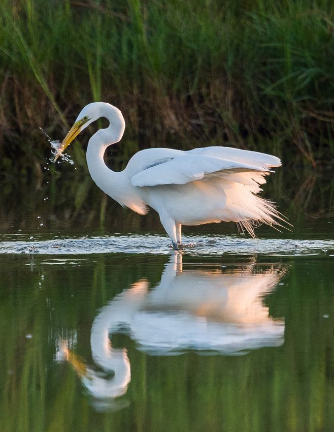
4Project 2001 CBBEP Coastal Bird Management
Performing Organization: CBBEP
Total Project Funding: $253,655
CBBEP Bays Plan Actions: HLR-1, HLR-4
Background:
Coastal birds are important components of estuarine ecosystems and serve as indicators of ecosystem health. In
addition, recreational bird viewing is a significant and growing component of ecotourism, a major facet of the local
economy. The 2010 Environmental Indicators Report prepared by CBBEP documented the declining populations of
many colonial waterbird species in Texas, with some species experiencing up to a 90% reduction in breeding pairs
since the 1960’s. Research continually provides evidence of the importance of the Texas coast to many other non-
breeding coastal bird species, many of which are also experiencing major population declines.
This project will build on the efforts of the CBBEP Colonial Waterbird projects from previous years through the continued
implementation and improvement of specific management actions from the CBBEP Colonial Waterbird Rookery Island
Management Plan. This plan outlines habitat management actions such as planting and establishing native shrubs,
removing exotic/invasive vegetation, building artificial nest platforms, and removing nest predators as needed
throughout the year. With approximately 60 islands to manage, the CBBEP will continue to strive to develop and
improve more efficient and effective methods of habitat management on rookery islands. All habitat management
actions such as planting native vegetation and removing exotic/invasive vegetation will be completed by February 1,
as this is the beginning of the waterbird nesting season. Predator management will be conducted on an as-needed
basis for the entirety of the year.
Additionally, these efforts will extend to activities that support the conservation of non-breeding coastal bird species
and their habitat. This project will provide assistance to other partners, where appropriate, in efforts to assess changes
in populations, current wintering and migratory movements, and important areas of habitat for non-breeding coastal
species. The timeline for these efforts will depend on the seasonality of the non-breeding species, but will begin
September 1, and be completed by June 15.
Years of experience working with coastal bird species in the Coastal Bend makes the CBBEP uniquely qualified to
provide expertise and assistance to partners and stakeholders working to conserve coastal birds. The CBBEP will
assist resource agencies, universities, and other stakeholders in joint efforts to monitor changes in coastal bird
populations at a large scale. These monitoring efforts will take place primarily in December and May and provide
information that helps direct waterbird management priorities for CBBEP for the coming years. In addition, the CBBEP
will meet with partners and stakeholders throughout the year to provide updated information on coastal bird species
ecology and management in the Coastal Bend area, aiding in regional planning and monitoring efforts.
Public outreach will also be a key component of this project, with the objectives of minimizing anthropogenic impacts
to rookeries, educating the public, and promoting stewardship of waterbird resources. This will be accomplished
through on-site signage at rookery islands, public presentations and events, and other forms of public communications
such as the distribution of flyers, regular updates on social media, interviews with local news agencies, and with the
regular engagement of volunteers. Public outreach efforts will take place throughout the year.
Project Objectives:
• Continue the restoration efforts of coastal bird populations through management of colonial waterbird nesting sites,
including habitat enhancement, protection, and predator control, and by reducing anthropogenic impacts to coastal
birds.
• Develop and implement public education and outreach programs that promote awareness and stewardship of coastal
birds and their habitats.
• Assist partners in efforts to observe changes in coastal bird populations for management purposes.
• Provide resource agencies, researchers, and other stakeholders with expertise on coastal bird ecology, habitats, and
conservation needs including assistance in tagging migratory birds for tracking.
• Provide resource agencies, researchers, and other stakeholders with expertise on coastal bird ecology, habitats, and
conservation needs including assistance in tagging migratory birds for tracking.
5Project 2002 Delta Discovery
Performing Organization: CBBEP
Total Project Funding: $259,179
CBBEP Bays Plan Actions: BTR-1, PEO-2, PEO-3, PEO-5
Background:
Delta Discovery has become the tagline for our entire education program. The educational program cost consists of
the following:
• Salary and continued training of CBBEP environmental educators & part time Teacher Naturalists.
• Supplies and facility expenses Nueces Delta Preserve educational (utilities, custodial and equipment.
• Bus funding for field trips.
• Supplies and food for teacher workshops
Teacher Workshops: CBBEP Environmental Educators will facilitate workshops throughout the school year. These
workshops will address local environmental science topics and will align to the TEKS objectives. Participating teachers
will receive SBEC credits. The workshops focus on equipping teachers with the skills, curriculum, support, and materials
to strengthen science teaching as it relates to the environmental treasures of the Texas Coastal Bend. Partnering
throughout the year would allow the CBBEP to introduce environmental issues to teachers who may not be able to
dedicate time in the summer to workshops. The funding provides all fees for partnering, curriculum, and substitute
teachers in order for these workshops to occur on weekdays. During the summer, the CBBEP partners with other
successful educational programs to provide teachers the tools needed to successfully teach science and promote
student awareness of local ecology and environmental issues affecting the bays and estuaries. CBBEP provides up to
three free summer workshops per year
Fieldtrips: Many of the students that are being exposed to scientific concepts for the first time have never spent much
time outdoors CBBEP Environmental Educators provide field trip opportunities for teachers and students to visit the
Nueces Delta Preserve. The cross-curricular trip may to be organized by the teacher, with assistance from the
Environmental Educator, to create an educational TEKS-aligned agenda for outdoor education. This program sees
over 8000 students per school-year. The goal is to plant seeds of appreciation and passion for a new generation of
naturalists, biologists, and nature lovers to protect and preserve the Coastal Bend through educating school children
about preserving our environment and protecting our animal and plant life.
Home School Days: Home School families often request field experiences, yet have difficulty meeting our minimum
student quota for the day. To better serve this audience, we offer five home school experience days to allow home
school families and their students an opportunity to connect their classroom science curriculum to the natural world of
the Coastal Bend using both place based and discovery education.
Delta Discovery Days: CBBEP will host ten Delta Discovery Days. These hands-on “picnic days” provide families time
and guidance to discover, connect and learn about the estuary in their back yard. Families bring a sack lunch and the
CBBEP Education Staff facilitates learning activities throughout the four-hour picnic.
Nature Story Time: CBBEP will host fourteen nature story times. These programs are geared for 2-5 year olds and
introduce children to nature and the joys of reading through stories, crafts, and outdoor play. Children and their families
will explore and connect with the estuary and its inhabitants.
Project Objectives:
• Provide educational field trips for K-12 students and also aid teachers in the community to increase their
knowledge, skills and provide resources to more effectively teach science to their students in local schools.
• Provide educational outdoor experiences to the coastal community residents that instill a sense of
appreciation/value of the area and desire for conservation natural resources.
6Project 2003 Nutrient Sampling in Petronila Creek
Performing Organization: Nueces River Authority
Total Project Funding: $40,722
CBBEP Bays Plan Actions: WSQ-3
Background:
Petronila Creek is a tributary to Baffin Bay. The health of Baffin Bay has been of great concern to scientists and
concerned citizens due to fish kills, water quality problems, and food web changes in the bay. The Baffin Bay
Stakeholder Group, formed in 2012 , is composed of scientists from Harte Research Institute (HRI) at Texas A&M
University-CC, Coastal Bend Bays and Estuaries Program, USDA-NRCS, Texas State Soil & Water Conservation
Board, Texas Water Resources Institute, Texas Commission on Environmental Quality, Texas Sea Grant, Texas
General Land Office, NRA, and a host of concerned citizens, including commercial and recreational fishermen,
ranchers, and business owners. This group has begun an effort to develop a watershed protection plan (WPP) for
Baffin Bay.
The scientists at HRI have determined that the primary causes of the water quality concerns are due to excessive
nutrients in the bay. To identify sources of these nutrient concentrations, monthly water quality monitoring for nutrients
will be conducted in Petronila Creek and its tributaries. The Nueces River Authority (NRA) collects chloride, sulfate,
and total dissolved solids (TDS) samples monthly at one main stem site and 10 tributary sites. Two additional main
stem sites are monitored quarterly for NRA's Clean Rivers Program (CRP), therefore monthly data is collected in the
non-CRP sampling months. This sampling is being conducted to support the Petronila Creek Implementation Plan (I-
Plan). NRA will add the nutrient samples (nitrate, nitrite, total Kjeldahl nitrogen, total dissolved Kjeldahl nitrogen,
ammonia, total phosphorus, chlorophyll-a, and pheophytin) to this monitoring. The nutrient data will be used to help fill
the data gaps with respect to identifying all possible sources of the nutrients.
Project Objective:
The objective of this project is to conduct monthly water quality monitoring of nutrients in Petronila Creek and its
tributaries for a period of one year to identify sources of excess nutrient concentrations in Baffin Bay. The nutrient data
from Petronila Creek and its tributaries will be utilized by the Baffin Bay Working Group to help guide them in their
watershed planning and restoration.
.
7Project 2004 Connecting Communities in the Oso Bay/Oso Creek Watershed
Performing Organization: Center for Coastal Studies at TAMUCC
Total Project Funding: $4,000
CBBEP Bays Plan Actions: PH-1, WSQ-1, WSQ-5, FW-1, PEO-5
Background:
Staff from the Center for Coastal Studies at Texas A&M University–Corpus Christi have been working with stakeholders
since 2013 to develop a plan for water quality improvements in the Oso Bay/ Oso Creek Watershed (Oso Watershed).
The efforts of this plan have identified the need to connect the urban and rural communities within the Oso Watershed,
specifically with the Colonias communities.
The Islander Stream Team, established in August 2015 at Texas A&M University-Corpus Christi (TAMUCC), is
composed of both undergraduate and graduate TAMUCC student volunteers. The students collect monthly water
quality data at sites along Corpus Christi Bay and Oso Bay. This project will give the Islander Stream Team latitude to
move out into the rural areas of the Oso Watershed and help build relationships with the Colonias communities.
The data collected by the Islander Stream Team is submitted to the Center for Coastal Studies at Texas A&M University-
Corpus Christi, which is the hub for the Coastal Bend Regional Stream Team. The Center for Coastal Studies takes
the water quality data through Quality Assurance/ Quality Control (QAQC) measures before final submission to the
Texas Stream Team database. Our partner, the Nueces River Authority supported the formation of the Islander Stream
Team by purchasing kits, standards, refractometers, buckets, and other supplies needed for the students to sample.
The funding will support the Islander Stream Team by allowing the team to continue to expand their sampling activities
to the rural areas of the Oso Watershed and connecting with the Colonias communities. Funds would also be used to
purchase standards and water quality kits. The Islander Stream Team, with the help of the Center for Coastal Studies,
will build relationships and communication with the Colonias communities using water quality monitoring as the
foundation. Breaking the barrier between urban and rural watershed communities and building a strong relationship
with the Colonias community is vital for the Oso Watershed TMDL and I-Plan process currently in progress by TCEQ.
The Islander Stream Team would be our conduit to connect the rural Oso Creek Colonias communities with the urban
communities along Oso Bay. This plan to connect communities in the Oso Watershed is essential and key to a
successful I-Plan for Oso Bay and Oso Creek. This will be accomplished by visiting rural grade-schools and giving
students hands on education about water quality using standard LaMotte Kits and visiting the Colonias communities
and talking with them about water quality. Building and growing communities in the Oso Watershed to protect our water
is the ultimate goal of this project.
Project Objective:
The project objective is to continue and expand water quality outreach and build relationships with residents in the
rural Colonias areas and urban communities of the Oso Bay/Oso Creek Watershed (Oso Watershed).
8Project 2005 Quantifying Septic Effuent Nitrogen Loading and Processing in the Baffin Bay
Watershed
Performing Organization: TAMU-CC
Total Project Funding: $51,750
CBBEP Bays Plan Actions: WSQ-3, NPS-3, FW-1
Background:
The Baffin Bay watershed is 2,177,965 acres and contains three tributaries: Petronila, San Fernando, & Los Olmos
creeks. There currently are impairments on two tributaries (Petronila Creek, San Fernando Creek), and ongoing water
quality degradation has been documented in Baffin Bay (e.g., prolonged brown tide events). The watershed is primarily
rural and privately owned.
The purpose of this project is to provide an estimate of septic system effluent nitrogen (N) loading and processing in
the Baffin Bay watershed. Septic systems provide a cost-effective means of wastewater disposal in rural areas lacking
access to a centralized wastewater treatment facility, however septic system effluent can lead to groundwater quality
decline and increased N loading to coastal waters. Due to the anaerobic conditions in septic systems, a majority of N
in the effluent exists as ammonium (NH4+) (70 to 90%) and dissolved organic N (DON) (10 to 30%). The effluent is
discharged to the surrounding natural soils and ideally the N is processed to harmless forms of N (e.g. N2). However,
depending on the physical and chemical properties of the natural soils and the depth of the water table, bioavailable
forms of N (e.g. NH4+, NO3-) can infiltrate the groundwater and subsequently be delivered to coastal waters. Increased
bioavailable N loading to coastal waters can cause detrimental effects including eutrophication and harmful algal
blooms. There are ~63,000 septic systems in the 18 counties of the Texas coastal zone and there is a lack of knowledge
of how the septic systems located in the Baffin Bay watershed may be contributing to coastal N loading. Porewater
NH4+ in Baffin Bay is an order of magnitude higher than other S. Texas estuaries and this may be partially due to
unprocessed septic system effluent infiltrating the groundwater. In order to develop informed mitigation strategies to
decrease the harmful effects of N loading in the region, it is necessary to understand the significance of each N source
contribution.
Project Objective:
This project will address the significance of septic N loading to the Baffin Bay watershed through three (3) objectives:
• Quantify nitrogen species in septic system effluent and groundwater
• Characterize transport and processing of nitrogen species to groundwater
• Provide a first estimate of septic system derived N load processing in the Baffin Bay Watershed using Soil
Treatment Unit Model
.
9Project 2006 Outdoor Classrooms
Performing Organization: CBBEP & USFWS
Total Project Funding: $10,000
CBBEP Bays Plan Actions: PEO-3, PEO-5
Background:
In several discussions with teachers and principals, it has been determined that moving students to learning
opportunities (field trips) is becoming more difficult. Buses are expensive and finding personnel to supervise, as well
as scheduling, has become challenging. Field trips at the middle school and junior high level are almost non-existent.
One way to solve this problem would be to bring learning opportunities to schools in the form of an outdoor classroom.
Outdoor classroom is defined as an outdoor area on campus set aside for student investigation and learning.
Components are varied but often include benches or picnic tables adjacent to a study or natural area where students
can gain field experience.
Objective:
To provide public schools with the option of an outdoor classroom that will promote interest in science, include
community experts, support parent involvement, provide field experience to students, and help to improve scores.
10Project 2007 Hurricane Harvey Debris Removal – CBBEP Tracts, Holiday Beach
Performing Organization: CBBEP
Total Project Funding: $100,000
CBBEP Bays Plan Actions: BD-2
Background:
Coastal Bend Bays and Estuaries Program’s (CBBEP) Holiday Beach property is a low-lying wetland habitat area and
consists of coastal marsh transitioning to estuarine marsh and sand flats. The debris present consists of construction
and housing materials and household items and is a result from the strong hurricane winds and tidal storm surge of
Hurricane Harvey. The highest points in elevation found on the property, mesquite tree mots, represent approximately
8 acres of dense debris fields. The remaining 170 acres has mostly scattered debris.
Success at this project site would consist of debris removal from the entire 170 acres, with minimal to no long-term
impacts to the existing sensitive habitats. Most of the 170 acre area will need to be handpicked or accessed by utility
vehicles. The debris that landed on higher elevations will be primarily removed by machines. Removal techniques will
include mechanical grapple, trailers, ATV/UTV, airboats, drone technology, and hand picking. Paid contractors and
volunteers will all be relied upon to assist in the removals. Debris will be hauled off to a permitted landfill. The debris is
currently covering plants and feeding areas that wildlife depends on. If left in place it could decrease abundance and
diversity of plant species found on the properties. Some of the debris is likely to be hazardous to wildlife and marine
resources. Landowners surrounding the property will be engaged and encouraged to participate as they directly benefit
by living adjacent to these natural areas. CBBEP will engage the Holiday Beach Property Owners Association about
projected timelines and volunteer opportunities. No permits are known to be required for this project area.
Project Objectives:
• Remove and dispose of debris from CBBEP owned properties located in the Holiday Beach area of Aransas
County.
• Pre and post assessment of the area using drone technology.
• Post assessment of the property once debris has been removed. Document any damage to the property and
implement necessary restoration actions.
11Project 2008 CBBEP Community Outreach Partnerships
Performing Organization: Coastal Bend Bays Foundation
Total Project Funding: $30,000
CBBEP Bays Plan Actions: PEO-1, PEO-2, PEO-3, PEO-4 and PEO-5
Background:
As stated in the Coastal Bend Bays Plan, CBBEP is constantly working to promote public/private partnerships to help
achieve its educational goals.
The CBBEP partnership with the Coastal Bend Bays Foundation (CBBF) addresses our educational goals set forth in
the Bays Plan. One of the benefits of the partnership between the CBBEP and CBBF is addressing the need for
continued dialogue between competing user groups and the need for an engaging public forum to allow for individual
input in the public policy debate. The Bays Plan calls for continued involvement from CBBF, as the region prepares
itself for ever-increasing number of people wanting to make use of the bays and estuaries. Minimizing conflict through
informed discussion will help achieve the overall objective of ensuring the public’s safety, health and enjoyment of our
bays and estuaries.
This project will result in increase in the community’s awareness of local environmental issues through Earth Day,
forums and an awards banquet. An estimated 12,000 people are expected to attend these events.
Project Objectives:
• Host, organize and coordinate turnkey operation of Earth Day festival.
• Host organize and coordinate CBBF Conservation and Environmental Stewardship Annual Awards Banquet.
• Conduct Coastal Issues Forums to increase communications between resource managers, users and general
public.
• Organize and coordinate bay-resource/related workshops with CBBEP’s approval.
• Continue to seek matching and/or leveraging funds.
12Project 2009 CBBEP Property Management
Performing Organization: CBBEP
Total Project Funding: $118,000
CBBEP Bays Plan Actions: HLR-1
Background:
CBBEP is owner and steward of properties in Nueces, San Patricio, Aransas, and Refugio Counties which includes the
10,500 acre Nueces Delta Preserve, public access properties, and more recently the Mission River Delta along the
Mission River and Mission Bay.
The CBBEP Nueces Delta Preserve is located 3 miles from the City of Odem and 20 miles from downtown Corpus
Christi. The CBBEP Nueces Delta Preserve consists of approximately 10,500 acres in San Patricio and Nueces
Counties that are owned and managed by CBBEP as a conservation site for the purpose of preserving natural habitat,
function and species diversity in the Nueces River delta. The preserve is rich in diversity that can be characterized by
Tamaulipan thorn scrub, grasslands, lomas, freshwater wetlands, riparian habitat, brackish wetlands, tidal mud flats
and estuarine shoreline. CBBEP’s secondary goal for the preserve is for the property to be used for a variety of
educational and research opportunities.
The funds provided by the project help support the land ownership obligations and some routine maintenance
associated with CBBEP owned properties. Maintenance activities including but not limited to paying for portions of
road maintenance, fencing replacement and repairs, brush control, equipment maintenance and purchases, habitat
and predator management (as appropriate and necessary), and the payment of property taxes.
Past project accomplishments include fencing projects, preparation for prescribed burns, constructed wetland dike
repair and vegetation manipulation, management of equipment purchases, building maintenance, volunteer project
coordination, application of herbicide to invasive brush, road repairs, creation of a wildlife observation area, and
establishing routine mowing of common areas and roadways.
Objectives:
• To provide the required ongoing maintenance and management of properties owned by Coastal Bend Bays &
Estuaries Program.
• Purchase of replacement mower deck for use in vegetation maintenance and manipulation. Including mowing of
roadways, fence lines, trails, and fireguards.
• Replace approximately 3.6 miles of perimeter fence.
13Project 2010 Functionality of Oso Bay Wind Tidal Flats
Performing Organization: Texas A&M University-Corpus Christi
Total Project Funding: $25,270
CBBEP Bays Plan Actions: HLR-1, HLR-2, HLR-4, SM-1, FW-1
Background:
The purpose of this project is to evaluate the effects of ongoing changes in the hydrodynamics of Oso Bay to tidal flat
productivity. Wind-tidal flats in the Texas Coastal Bend are preferred shorebird foraging habitat and provide critical
food resources during a stressful part of annual cycle, migration and winter at the Oso Bay flats around Ward Island
are designated critical habitat of endangered/threatened Piping Plover; about half of the continental population of the
species winters in Texas. Many other shorebirds use Oso Bay tidal flats. More than 50% of the historical extent of wind-
tidal flats in the Coastal Bend have already been lost, largely due to relative sea-level rise which converts flats to either
permanently submerged habitat, or vegetated habitat. From the standpoint of tidal flat functionality as shorebird
foraging habitat, increasing vegetation on the Blind Oso wind-tidal flats is one of the most damaging effects of the
alterations to hydrology that have occurred over the last 40+ years. Vegetated habitats, especially those with water
depths that exceed 1-2 cm are not suitable habitat for foraging shorebirds. Increased wastewater outflow will continue
and hasten expansion of marsh vegetation on the flats, particularly the flat in the Blind Oso, which will result in reduced
suitability of the tidal flats around Ward Island as shorebird habitat.
Project Objectives:
• Compile and review the recent literature on biotic and abiotic process and dynamics related to wind-tidal flats in
Oso Bay
• Map the current extent of marsh vegetation in Oso Bay from SPID to Ward Island (excluding NAS) and characterize
its species composition
• Evaluate the functionality of the tidal flats using the method developed in Withers and Tunnell (1998), a project
that was funded by the CCBNEP (now CBBEP).
14Project 2011 Nueces Delta Environmental Monitoring Project
Performing Organization: Conrad Blucher Institute
Total Project Funding: $60,644
CBBEP Bays Plan Actions: FW-1, FW-2, FW-3, FW-4
Background:
The purpose of this project is for the Conrad Blucher Institute to continue to maintain 3 current real-time salinity
monitoring stations along the Rincon Bayou, and a fourth station at “South Lake” and continue to maintain a tide gauge
in west Nueces Bay in order to characterize freshwater inflows into the Nueces Delta. Salinity sensors along the Nueces
Delta will be used to trace freshwater inflows from freshwater pumping events via the Rincon Bayou Pipeline from the
Nueces River and will report water temperature, conductivity, and salinity every 30 minutes. Data from these salinity
stations will be used to aid in the development of management strategies for the Rincon Bayou Pipeline. The Center
for Coastal Studies, the Harte Research Institute at TAMUCC use the salinity data provided from the salinity stations
to support various projects involving sampling in the Nueces Delta. Data from these salinity stations are also utilized
by the University of Texas (UT) at Austin and the UT Marine Science Institute in Port Aransas to support various
modeling projects which are investigating the interactions between water in sediment and tidal creeks in the Nueces
Delta. The Nueces Delta Hydrodynamic Model being conducted by UT also utilized the tide gauge data in the western
Nueces Bay. Several Texas Water Development Board funded projects have and currently are utilizing the available
data. A weather station will also be maintained in the Nueces Delta and will provide air temperature, wind, precipitation,
barometric pressure, relative humidity, and solar radiation data. All data will be available to the public on the contractor's
webpage.
Normally, a river flows through a delta area prior to making its confluence with its receiving water body. The Nueces
River is different in that it flows into Nueces Bay at a point along the south shore of the bay, 2 ½ to 3 miles from the
delta-bay interface, completely bypassing the delta. Only during times of severe flooding, causing over-banking of the
river, or locally heavy rain, did much freshwater make it into the delta proper. To provide more freshwater diversions
during normal flow conditions, the City of Corpus Christi built a pipeline and pump station to divert up to the first 3,000
acre-feet of pass-throughs per month from above the saltwater barrier dam directly into the upper Rincon Bayou.
The primary project objectives will be to continue monitoring the freshwater inflows coming into the delta via the pipeline
by recording salinities within the water column at various stations along the Rincon Bayou and within the Nueces Delta,
as well as to maintain a real-time weather station and a tide gauge in Nueces Bay for the period of one year. These
instruments will be used to calculate spatial and temporal environmental effects as well as the amount of freshwater
needed to manage a healthier estuary.
Objective:
Maintain real-time water quality, tide gauge, and meteorological monitoring stations in the Nueces Delta and Bay to
measure effects of Rincon Pipeline freshwater inflows.
15Project 2012 City of Port Aransas Nature Preserve – New Trail Connection/Boardwalk
Performing Organization: City of Port Aransas
Total Project Funding: $23,417
CBBEP Bays Plan Actions: HLR-1, PEO-1, BD-1, FW-1
Background:
Since the conceptual plans for the Preserve first started, in 2002, there has been a desire to connect the Leonabelle
Turnbull Birding Center and the Charlie’s Pasture trail system. This site received over 60,000 visitors in 2017. Hurricane
Harvey destroyed the existing boardwalk and observation tower at this site and has expedited the need to build this
trail connection and restore access to the freshwater wetlands and pond habitat that draw so many eco-tourists to the
area. The geographic scope of Port Aransas includes stopover habitat for neotropical migrating birds in the spring and
fall, summer nesting grounds for a variety of birds, wintering grounds for the endangered Piping Plover and Whooping
Crane. This location brings in a tremendously diverse amount of birds. Families on summer vacation, nature lovers
chasing migration and annually returning Winter Texans all frequent the site. Based on a study conducted by the City,
the Nature Preserve was ranked as the most important recreation need of the region. There is great potential for loss
of tourism due to destruction of the boardwalk and limited access to the site that could make a large impact to Port
Aransas’ eco-tourism driven economy.
A 500ft boardwalk and 20ft tall observation tower has been designed as a hike and bike trail and will create a new tie
in to the Port Aransas Community Park as well as the only remaining Nature Preserve trail. The boardwalk will be
constructed from more resilient materials than the previous lumber boardwalks. Work will be done in phases eventually
creating a loop of trails that connects each of the popular nature destinations to each other. This project has been given
$400,700 by the Rebuild Texas Fund to cover debris removal and new construction. The total project cost for debris
removal, construction of the boardwalk and construction of the observation tower is $776,200. FEMA will not cover the
construction of the boardwalk or observation tower as they are new constructions, and FEMA support is restricted to
the rebuilding of previous structures.
Project Objectives:
• Continuation on the construction of public access improvements that were severely damaged by Hurricane Harvey.
• Construct in part a ADA concrete sidewalk that ties portions of the Port Aransas Nature Preserve to existing
boardwalks and hiking trails.
• Construct and or improve existing access locations providing residents and visitors an enhanced experience while
at the Port Aransas Nature Preserve.
16Project 2013 Water Quality Monitoring Program in Baffin Bay
Performing Organization: Texas A&M University-Corpus Christi
Total Project Funding: $50,000
CBBEP Bays Plan Actions: WSQ-3
Background:
The purpose of this project is to help continue a water quality monitoring program in Baffin Bay that will gather water
samples and identifying potential sources of water quality degradation in the system. Baffin Bay is also undergoing
significant eutrophication, as exemplified by a long-term increase in nitrogen and phosphorus loads and chlorophyll a
concentrations that have exceeded state criteria for nearly the past decade (Montagna and Palmer 2012). Additional
symptoms include blooms of potential HAB species (A. lagunensis, Pyrodinium bahamense), episodic hypoxia and fish
kills.
In response to concerns over water quality changes in Baffin Bay, Texas A&M University-Corpus Christi (TAMU-CC)
has initiated a spatially-temporally intensive water quality monitoring program to: 1) generate data for construction of
nutrient budgets and to identify potential sources of nutrient/organic matter loadings that are contributing to water quality
degradation in the system, and 2) characterize the ecosystem response to loading events, including from episodic
storm events.
As part of the program and a TAMU-CC Ph.D. student project, samples will be collected at six sites from Baffin Bay on
a monthly basis, as well as at higher frequencies in response to episodic storm events or fish kills. Two of the sites
overlap with TCEQ quarterly monitoring stations, allowing for comparison with longer-term trends within Baffin Bay. At
each site, vertical profiles will be performed and discrete surface samples collected. Additionally, a YSI Ecomapper
Autonomous Underwater Vehicle (AUV), equipped with water quality sensors (temperature, salinity, D.O., pH,
chlorophyll fluorescence) may be deployed to identify water quality “hot spots” and to characterize environmental
conditions pre- and post-storm.
Project Objective:
The objective of this project is to support a water quality monitoring program through TAMU-CC and collect monthly
data, and rain event data, to identify nutrient concentrations and loading throughout the bay system.
17Project 2014 CBBEP Public Outreach Events and Activities
Performing Organization: CBBEP
Total Project Funding: $43,500
CBBEP Bays Plan Actions: PEO-1, PEO-2, PEO-3, PEO-4, PEO-5, BTR-1
Background:
One of the most important goals of the Coastal Bend Bays Plan is to educate citizens about the ecology of the bay
system, its many environmental and economic values, and how an individual can make a positive difference to ensure
its long-term health. To accomplish this, the Public Education and Outreach Action Plan is designed to raise the public’s
environmental awareness, foster community stewardship of bay resources; and increase individual involvement in bay
resource management issues.
Helping residents and visitors understand the complex issues concerning bay resource management is a priority.
CBBEP utilizes a public opinion survey to gauge the effectiveness of our education and outreach efforts. In addition to
understanding how the bay system functions, it is important that citizens develop a sound appreciation for the significant
value and economic impact derived from the renewable resources of the bays. CBBEP is constantly working to promote
public/private partnerships as stated in the Coastal Bend Bays Plan to help achieve its educational goals.
Objective:
CBBEP will raise awareness of environmental issues by connecting with the Coastal Bend public through our websites
and at community events and festivals. We will spread the CBBEP brand through promotional and educational
materials, such as posters, reusable bags and other items. We expect to reach thousands of people at various
community events.
In addition, CBBEP may participate in:
• Community events and festivals
• CBBEP may produce or purchase educational and promotional materials
• CBBEP will maintain a web site(s)
• CBBEP develop and provide electronic updates
• Other outreach opportunities
18Project 2015 MarineGEO Texas Biodiversity Assessment 2019
Performing Organization: Texas A&M University Corpus Christi
Total Project Funding: $32,732
CBBEP Bays Plan Actions: HLR-1, HLR-2, PEO-1
Background:
Gulf waters are extraordinarily rich and nurture 8% of the world’s marine biodiversity (Felder 2009, Mora et al. 2011).
The Coastal Bend’s location at the transition between temperate and tropical climates make it a key area for
understanding how coastal marine ecosystems work, how they are structured, and how they respond to climate change.
The purpose of this project is to disseminate the results of a rigorous biodiversity inventory of estuarine habitats in the
Texas Coastal Bend. Leveraging commitments from UTMSI, TAMUCC, and the Smithsonian Tenembaum Marine
Observatory Network, the work will produce a comprehensive list of invertebrate and fish species identified and
confirmed by expert taxonomists, with associated genetic barcodes, high resolution images, and voucher specimens
curated by the Smithsonian Museum of Natural History. The results of this "bioblitz" will be disseminated to technical
and non-technical audiences in the form of a technical report and summary, a white paper fact sheet for the general
public, and a short video developed and disseminated by the Texas State Aquarium (TSA). The video is anticipated to
reach an audience of greater than 100,000 viewers, through showings in the TSA 4D Theater, use in TSA Educational
STEM Programs, and dissemination by partner organizations involved in the “bioblitz” (Smithsonian, TAMUCC, UTMSI)
and museums and aquariums in the TSA professional network. Specific technical outcomes will include:
This common resource will be of value to ecosystem and fisheries management, conservation work, research
endeavors, and increasing public awareness of the incredible diversity of life present in the waters of the Coastal Bend.
Project Objectives:
The project objectives are the development and dissemination of:
• A list of species present in estuarine habitats of the Coastal Bend
• A list of species previously undescribed by science
• A list of species previously undescribed in the region (comparisons with CBBEP Species
Checklist and state surveys)
• A list of exotic species previously undescribed in the region
• Technical summarizations of regional biodiversity by bay system and habitat including
phylogenetic diversity.
• A publicly accessible library of taxonomic barcodes for use in future studies such as
metagenomic biodiversity sampling, diet studies (gut-content analysis), and environmental DNA surveys.
19Project 2016 Texas Marine Mammal Stranding Network - Coastal Bend
Performing Organization: Texas Marine Mammal Stranding Network – Coastal Bend
Total Project Funding: $5,000
CBBEP Bays Plan Actions: HLR-5
Background:
Texas Marine Mammal Stranding Network (TMMSN) is a 501(c)(3) on-profit organization established by researchers
in 1980, and is dedicated to the rescue, rehabilitation, and research of marine mammals along the Texas coast. TMMSN
is the only organization in the state of Texas authorized under the Marine Mammal Protection Act to respond to marine
mammal stranding events and operates as a branch of the national Marine Mammal Health and Stranding Response
Program. TMMSN is a dedicated group of trained individuals committed to promoting the conservation of marine
mammal species and their habitats. The TMMSN Coastal Bend team needs to be ready to deploy a reserve of
specialized response equipment and a dedicated corps of local volunteers at a moment’s notice.
The purpose of this proposed project is to support the efforts of the Corpus Christi and Port Aransas (Coastal Bend)
regions of the TMMSN by updating essential field supplies and equipment that will last for multiple years.
Project Objective:
The allotted funding is for the purchase of new supplies and equipment, so that the Coastal Bend TMMSN can continue
to perform the following objectives:
• Properly train individuals to be safe volunteers within the network
• Provide volunteers with personal protective equipment and supplies
• Provide a reliable and safe means of transportation to and from sometimes remote locations and in less than
optimal conditions
• Improve the survival rates of stranded marine mammals by applying what we learn from each event to improve
response protocols
• Provide researchers the opportunity and means to advance science
• Educate the public
20Project 2017 Waters for Wildlife: Increasing Freshwater Resources for Whooping Cranes
Performing Organization: San Antonio Bay Partnership
Total Project Funding: $17,000
CBBEP Bays Plan Actions: HLR-1, HLR-2
Background:
Providing freshwater resources to Aransas-Wood Buffalo (AWB) Whooping Cranes, the last naturally migrating
population, in their only wintering grounds in the central Texas coast is critical to their survival, health and ability to
migrate back to their Canadian breeding grounds. SABP received CBBEP funding in 2014 to develop a Water Well
Suitability Index GIS platform to identify and prioritize sites where freshwater resources are needed for cranes. Criteria
used for site evaluation will include wetland characteristics (i.e., altered by excavation, impoundment, levees or natural
depression; distance from other freshwater resources) and distance to occupied crane territories and land ownership.
Last year, Hurricane Harvey damaged all solar panels and functioning windmills in the core wintering area, and SABP
was successful in completing repairs in time for 2018-2019 season. This year, SABP continues to address areas where
freshwater availability is still lacking by installing a well by a local contractor at a prioritized wetland site.
Project Objective:
The objective of this project is to incorporate information generated from previous monitoring projects (2012-2018)
and use the Water Well Suitability Index to identify one wetland site within the current wintering range of the
Endangered Whooping Crane and install a solar-powered water well.
21Project 2018 Triangle Tree Rookery Island Protection
Performing Organization: TBD
Total Project Funding: $125,000
CBBEP Bays Plan Actions: HLR-1, HLR-2
Background:
Triangle Tree, an island in the upper Laguna Madre immediately south of Corpus Christi (27.554147, -97.286063), is
approximately 2 acres in size. The island is owned by the Texas General Land Office (TXGLO) and leased for the
purposes of protection and management of colonial nesting waterbirds by Audubon Texas. The CBBEP has partnered
with Audubon Texas to manage and protect rookery islands, including Triangle Tree, throughout the mid and lower
Texas coasts for over 15 years. Currently, the northern edge of the island is experiencing erosion, primarily from wave
damage produced during heavy cold fronts throughout the year. Erosion at a rate of approximately 2.5 ft/yr is occurring
where mature native shrubs have been established and some of these shrubs are beginning to fall into the water.
This project will include preliminary engineering, alternatives analysis, and 70% construction plan design. The final
engineering and design will include a structure designed to protect the north side of Triangle Tree Island from wind and
wave erosion and will also trap and secure sediment from future dredge placement events. It is anticipated that the
structure will be a minimum of 900 feet in length and positioned to protect the existing rookery habitat.
Project Objectives:
The objective of this project is the long-term shoreline protection of the Triangle Tree Rookery Island from wind and
wave erosion
22Project 2019 Improving Stormwater Management for the City of Port Aransas
Performing Organization: City of Port Aransas
Total Project Funding: $30,000
CBBEP Bays Plan Actions: WSQ-1, HLR-1, PEO-5
Background:
In the aftermath of Harvey, the City of Port Aransas is committed to better management of stormwater, increasing
resiliency in flood events and reducing and/or eliminating direct inputs of stormwater into the bay and Gulf of Mexico.
Currently the city's stormwater drains into the City Marina, Corpus Christi Bay, the Gulf of Mexico or into wind-tidal flats.
Sedimentation of the flats, extreme tides and sea level rise has caused water to stack up preventing proper draining.
This is a critical time to improve stormwater management to reduce non-point source (NPS) pollution and protect vital
fish habitat.
In a joint effort with the Mission-Aransas NERR at the UT Marine Science Institute, our goal is to reduce NPS pollution
into local waters, reduce flooding from improper drainage and high tides, and inform our citizens of the value of our
coastal resources and their role in ensuring sound management. Steps to accomplish this goal are: 1) Hire
consultant/engineer to complete a data review of LIDAR and historical data for Port Aransas, including relative sea
level rise model projections. 2) Formalize the Stormwater Advisory Group to recruit project partners and community
members. 3) Communicate data review findings to Advisory Group and evaluate the applicable sections of the
“Guidance for Sustainable Stormwater Drainage on the Texas Coast” for use in Port Aransas stormwater
management.4) Develop a Port Aransas Stormwater Management Plan for new development and ideas to retrofit
existing development to improve stormwater quality and reduce stormwater to the bay. 5) Involve the local community
and area resource managers through workshops. 6) Create City ordinance and outreach campaign for improved
stormwater management.
Success will be measured by these deliverables:1) Establishment of an Advisory Group that meets regularly 2)
Completion of a data review Report 3) Completion of the Port Aransas Stormwater Management Plan 4) Written
ordinance for Stormwater Management ready to present to the Port Aransas City Council for approval
Project Objective:
The project objective is to reduce NPS pollution into local waters, reduce flooding from improper drainage and high
tides, and inform citizens of the value of or coastal resources and their role in ensuring sound management.
23You can also read