EPOS-TCS Volcano Observations makes hazard information accessible and searchable
←
→
Page content transcription
If your browser does not render page correctly, please read the page content below
EPOS-TCS Volcano Observations makes hazard information accessible
                        and searchable

                                                                                                   The EPOS Newsletter issue 04
                                                  Sara Barsotti,
                                                                                                       October 2017 | Article 02

                                                  Fjalar Sigurðarson
                                                  IMO, Iceland

                                                  Laura Sandri
                                                  INGV, Italy

                                                  EPOS-TCS Volcano Observations aims to provide long-term
                                                  sustainable access to data, products, services and software
                                                  presently existing at European Volcano Observatories and Volcano
                                                  Research Institutions. This is built upon decades of infrastructure
                                                  operated by these Observatories and Institutions, and their long-
                                                  term data sets and research material. Within EPOS, this TCS will
                                                  implement interoperable services to allow discovery and seamless
                                                  access to this broad type of data and services.

                                                  Among the data and services provided, six partners (either Volcano
                                                  Observatories and Research Institutions) are collaborating on an
                                                  ambitious task: IMO, INGV, IPGP, CSIC, UAc, CNRS-OPGC (Acronym)1
                                                  are working with a common goal of quantifying hazards associated
                                                  with volcanic eruptions, and making this information accessible and
                                                  understandable to key end-users, such as the Civil Protection and
                                                  the general public.

                                                  The first step towards this goal was to perform a systematic review
                                                  of available products suitable for volcanic hazard assessment and
                                                  hazard communication in use at different Volcano Observatories.
                                                  The main effort was twofold: 1. to list the existing material (for
                                                  example maps, graphs, guidelines, manuals, visualization tools) and
                                                  2. to design standard metadata for an effective description of such
                                                  material.

                                                  What do we mean with the expression
                                                  "volcanic hazard products"?
                                                  Talking about hazard means talking about anything that can
                                                  potentially generate adverse events and consequently create
                                                  damage to the population and/or environment (Marzocchi et al.

                                    European Plate Observing System www.epos-ip.org | info@epos-ip.org | epos@ingv.it
   This project has received funding from the European Union’s Horizon 2020 research and innovation programm under grant agreement N° 676564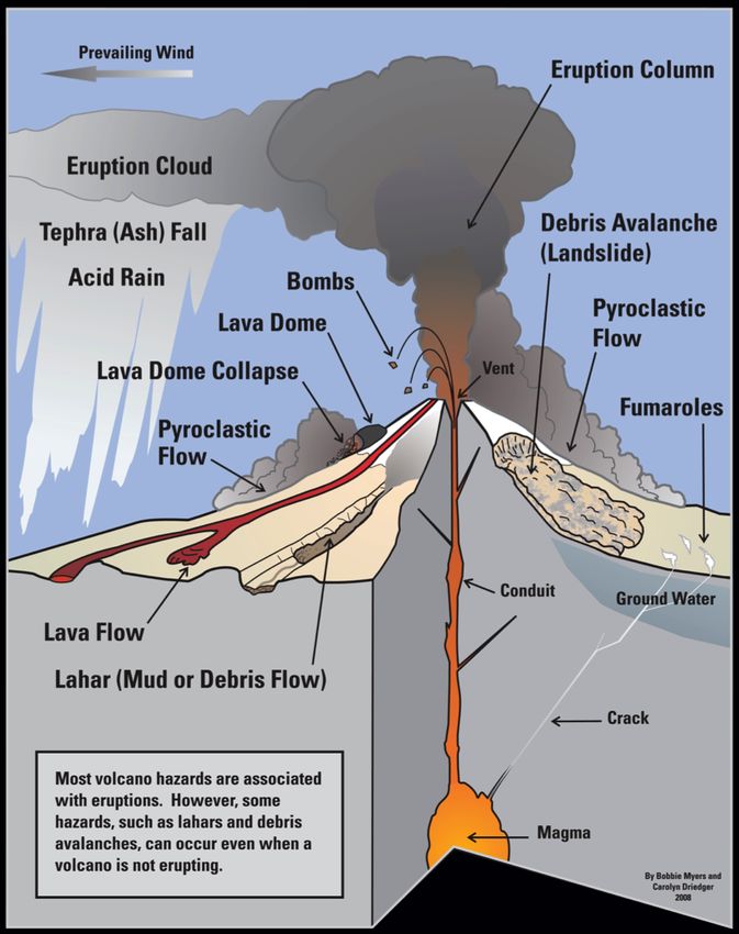
2012). In volcanology we mean all those dangerous phenomena that
                                               might occur in such a geological/environmental context and that can
                                               have implications for human, social and economic life. Volcanic
                                               hazards associated with a volcanic unrest and/or eruption can be
                                               many (see Figure 1)2; among them, the ones mostly targeted by
                                               volcanic hazard studies are: ballistics; volcanic ash and tephra;
                                               pyroclastic density currents and blasts; lahars and floods; debris
                                               avalanches, landslides and tsunamis; volcanic gases and aerosols;
                                               lava flows and domes; volcanic          earthquakes and/or ground
                                               deformation; lightnings (Loughlin et al. 2016).

                                               To quantify and visualize volcanic hazard, several tools have been
                                               developed within the research community and some of them are
                                               operational within Volcano Observatories.

                                               The most common way to convey information on volcanic hazard is
                                               by drawing the spatial extension of one of the above-mentioned
                                               hazardous phenomena on a geo-referenced map. Different types of
                                               map exist and they differ for the type of raw data used to assess the
                                               extension of the impacted area (geological data or simulation
                                               results), the type of information plotted on the map (an intensity
                                               measure of the investigated phenomenon, or the probability of its
                                               occurrence), the temporal constrain of validity for such a map, the
                                               background map, and so on (Calder et al. 2015).

                                               A map showing the probability of invasion due to pyroclastic density
                                               currents at Campi Flegrei (Figure 2), given the occurrence of an
                                               eruption, is a probabilistic (since it displays the probability) hazard
                                               map.

                                               It is an example of volcanic hazard product.

                                               Another common way to convey information on volcanic hazard is
                                               by means of Event-Trees, that are are a schematic way to represent
                                               the possible behaviour of a volcano and the different possible
                                               outcomes of volcanic unrest. Event-Trees are usually drawn based
                                               on our knowledge of the historical or geological activity of the
                                               volcano studied, or of other volcanoes deemed similar to it. The
                                               schematic nature of Event-Trees helps understanding the logical
                                               step leading to different outcomes of volcanic activity, and their use
                                               during volcanic crises can help volcanologists both in critically
                                               reviewing and mutually discussing their hazard analysis, but also
                                               officials and individuals to compare volcanic risks with more familiar
                                               risks (Newhall and Hoblitt, 2002).

                                               An example of Event-Tree for Teide-Pico Viejo stratovolcanoes is
                                               shown in Figure 3 (Martí et al. 2008)3.

                                               This type of product is also a volcanic hazard product, and its use is
                                               increasing at Volcanic Observatories or Research Institutions.

                                               With the goal of making hazard information accessible and

                                 European Plate Observing System www.epos-ip.org | info@epos-ip.org | epos@ingv.it
This project has received funding from the European Union’s Horizon 2020 research and innovation programm under grant agreement N° 676564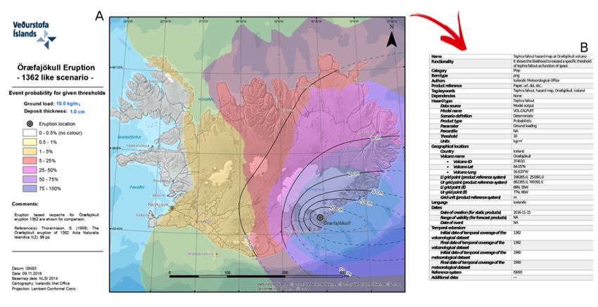
searchable, a review has been done across the different EU Volcano
Observatories to list the most common volcanic hazard products
presently available and in use. This has been done with the main
goal to compile a catalogue and, at the same time, to create the
conditions for a general efficient description of those products, that
is formally obtained by the identification of metadata.
How can we "describe" volcanic hazard
products by means of metadata?
With metadata we mean a set of data that can help in... describing
other data! By listing a set of metadata for specific products (maps,
table, graphs, monitoring data) we create the condition for these
products to be effectively searchable (and findable) through a
database. This is the best way to make products more easily found,
consulted and exploited by the community.
As mentioned in the previous section, a variety of products exist to
quantify/visualize/communicate volcanic hazard, making the task of
unifying their metadata challenging. Despite this variety, a first
attempt has been done to identify the basic metadata for these type
of products. A version 1.0 of these metadata has been created
within the EPOS - TCS Volcano Observations (as shown in Figure 4).
The list includes all those descriptors that will allow the
identification of a specific product unequivocally.
Metadata for volcanic hazard products are structured on four main
domains: general descriptors, type of hazard described,
geographical coverage and temporal descriptors. For example:
Descriptors regarding the functionality of the product (i.e.
which is its main use) is under the domain “General
descriptors”.
The identification of which intensity measure (e.g. pyroclastic
density current temperature) is used to describe the impact
of a specific hazard is under the domain “Type of hazard
described”.
The volcano for which the product is applicable (e.g. Mt. Etna)
is under the domain “Geographical coverage”.
The time of validity (e.g. 48 hours) of a given forecast map for
tephra accumulated at the ground, based on the wind
forecast for the next 48 hours and on a given eruptive
scenario, is under the domain “Temporal descriptors”.
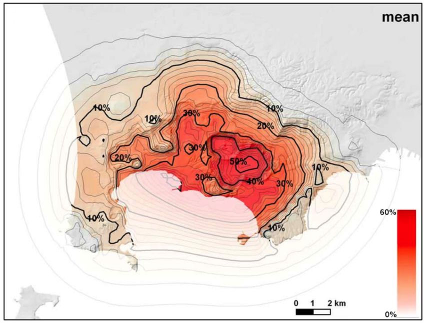
Finally, in Figure 5 we show an example of volcanic hazard product
(panel A, displaying the map of the probability of tephra
accumulation at ground in 24 hours, given an eruption of VEI=6 size
occurring at Öræfajökull volcano in Iceland), and how it is possible
to unequivocally describe it by the Metadata scheme proposed
European Plate Observing System www.epos-ip.org | info@epos-ip.org | epos@ingv.it
This project has received funding from the European Union’s Horizon 2020 research and innovation programm under grant agreement N° 676564(panel B).
The newly developed metadata will be adopted to implement the
search and query of volcanic hazard products through the EPOS
web-service. In this way any potential user interested in information
and products on volcanic hazards for European volcanoes will easily
find them, download them and use them, respecting the ownership
of the authors and the scientific and/or legal conditions under which
the products is valid.
The Volcano Observatories in Europe together with the European
Research Institutes will continue to produce new and innovative
products in the future that will support the difficult task of assessing
and communicating volcanic hazard.
Needless to say that the metadata structure will be updated to
either account these new volcanic hazard products, or to further
detail the description of the products already listened.
Overall, the work carried out so far by the “Hazard” sub-task of
WP11 “Volcano Observations” is aimed at facilitating the access to
research and operational products, which is considered a vital
objective for building a science at the service of the community.
WP11 accepted the challenge of fostering the integration of
scientific knowledge for a general public understanding. In this
vision, EPOS is the fundamental infrastructure that will make this
real and achievable in the next years.
1
Acronyms
IMO – Icelandic Meteorological Office, Iceland
INGV – Istituto Nazionale di Geofisica e Vulcanologia, Italy
CSIC - Consejo Superior de Investigaciones Científicas, Spain
UAc - University of the Açores, Portugal
IPGP - Institut de Physique du Globe de Paris, France
CNRS-OPGC - Observatoire de Physique du Globe de Clermont-Ferrand,
France
2
Figure 1. Sketch of possible hazardous phenomena of volcanic
origin, mostly associated with eruptions. However, some of them,
such as lahars and debris avalanches, can occur even when a
volcano is not erupting. Adapted from Myers B. & Driedger C.
(2008), Geologic hazards at volcanoes: U.S. Geological Survey,
General Information Product 64, 1 sheet
[http://pubs.usgs.gov/gip/64/]
3
Figure 3. Event-Tree designed for Teide-Pico Viejo
stratovolcanoes (Tenerife, Canary Islands, Spain) during the
Exploris project. From left to right, the logical steps leading to
hazardous outcomes are represented. In particular, we start from
a generic unrest event, which can lead or not to Sector failure. In
European Plate Observing System www.epos-ip.org | info@epos-ip.org | epos@ingv.it
This project has received funding from the European Union’s Horizon 2020 research and innovation programm under grant agreement N° 676564case of no sector failure, eruption may or may not develop, and if
it does, it can be from a central vent or from a flank. Different
hazardous phenomena are expected accordingly. In case of
sector failure, a flank eruption is expected, again with different
possible consequent hazardous phenomena. The numbers
indicated in each branch represent the 5th-50th-95th percentiles
of the probability distribution describing each branch. Modified
after Marti et al. (2008).
Back to newsletter
European Plate Observing System www.epos-ip.org | info@epos-ip.org | epos@ingv.it
This project has received funding from the European Union’s Horizon 2020 research and innovation programm under grant agreement N° 676564You can also read