(EVENING) All India Impact Based Weather Warning Bulletin
←
→
Page content transcription
If your browser does not render page correctly, please read the page content below
All India Impact Based Weather Warning Bulletin
Monday 11 January 2021
Time of Issue: 1630 hours IST
(EVENING)
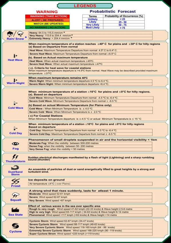
11 January (Day 1): ♦ Heavy to very heavy rainfall at isolated places very likely over Tamilnadu, Puducherry & Karaikal
and Kerala & Mahe and heavy rainfall at isolated places over Lakshadweep.
♦ Thunderstorm accompanied with lightning at isolated places very likely over south Coastal Andhra Pradesh, South
Interior Karnataka, Tamilnadu, Puducherry & Karaikal, Kerala & Mahe and Lakshadweep.
♦ Dense fog conditions at isolated places very likely over Sub-Himalayan West Bengal & Sikkim, Odisha, Uttarakhand,
Punjab, Haryana, Chandigarh & Delhi and north Rajasthan.
♦ Cold Wave to severe Cold Wave conditions in isolated pockets very likely over Punjab, Haryana, Chandigarh & Delhi and
Rajasthan.
♦ Cold Day to severe Cold Day conditions in many pockets very likely over Punjab and Haryana, Chandigarh & Delhi and in
isolated pockets over West Uttar Pradesh. Cold Day conditions in isolated pockets over Rajasthan.
♦ Squally weather (wind speed reaching 45-55 kmph) very likely over Comorin area, Gulf of Mannar and Southwest Bay of
Bengal. Fishermen are advised not to venture into these area.
12 January (Day 2): ♦ Heavy to very heavy rainfall at isolated places very likely over Tamilnadu, Puducherry & Karaikal
and Kerala & Mahe and heavy rainfall at isolated places over Lakshadweep.
♦ Thunderstorm accompanied with lightning at isolated places very likely over Tamilnadu, Puducherry & Karaikal, Kerala &
Mahe and Lakshadweep.
♦ Dense fog conditions at isolated places very likely over Sub-Himalayan West Bengal & Sikkim and Uttarakhand.
♦ Cold Wave to severe Cold Wave conditions in some pockets very likely over Punjab, Haryana, Chandigarh & Delhi and
in isolated pockets over Rajasthan. Cold Wave conditions in isolated pockets over West Uttar Pradesh.
♦ Cold Day to severe Cold Day conditions in some pockets very likely over Punjab and Haryana, Chandigarh & Delhi and
Cold Day conditions in isolated pockets over West Uttar Pradesh and Rajasthan.
♦ Squally weather (wind speed reaching 45-55 kmph) very likely over Southeast Arabian Sea along and off Kerala coast and
Lakshadweep area. Fishermen are advised not to venture into these area.
13 January (Day 3): ♦ Heavy rainfall at isolated places very likely over Tamilnadu, Puducherry & Karaikal and Kerala &
Mahe.
♦ Thunderstorm accompanied with lightning at isolated places very likely over Tamilnadu, Puducherry & Karaikal, Kerala &
Mahe and Lakshadweep.
♦ Dense fog conditions at isolated places very likely over Sub-Himalayan West Bengal & Sikkim.
♦ Cold Wave to severe Cold Wave conditions in some pockets very likely over Punjab, Haryana, Chandigarh & Delhi and
in isolated pockets over Rajasthan. Cold Wave conditions in isolated pockets over West Uttar Pradesh.
♦ Cold Day to severe Cold Day conditions in isolated pockets very likely over Punjab and Haryana, Chandigarh & Delhi and
Cold Day conditions in isolated pockets over West Uttar Pradesh and Uttarakhand.
♦ Squally weather (wind speed reaching 45-55 kmph) very likely over Southeast Arabian Sea along and off Kerala coast and
Lakshadweep area. Fishermen are advised not to venture into these area.
14 January (Day 4):♦ Dense fog conditions at isolated places likely over Assam & Meghalaya and Nagaland, Manipur,
Mizoram & Tripura.
♦ Cold Wave conditions in isolated pockets likely over Punjab, Haryana, Chandigarh & Delhi, Rajasthan and West Uttar
Pradesh.
♦ Cold Day conditions in isolated pockets likely over Uttarakhand.
* Red color warning does not mean "Red Alert" Red color warning means "Take Action".
Forecast and Warning for any day is valid from 0830 hours IST of day till 0830 hours IST of next day
For more details kindly visit www.imd.gov.in or contact : +91 11 24631913, 24643965, 24629798
(Service to the Nation since 1875)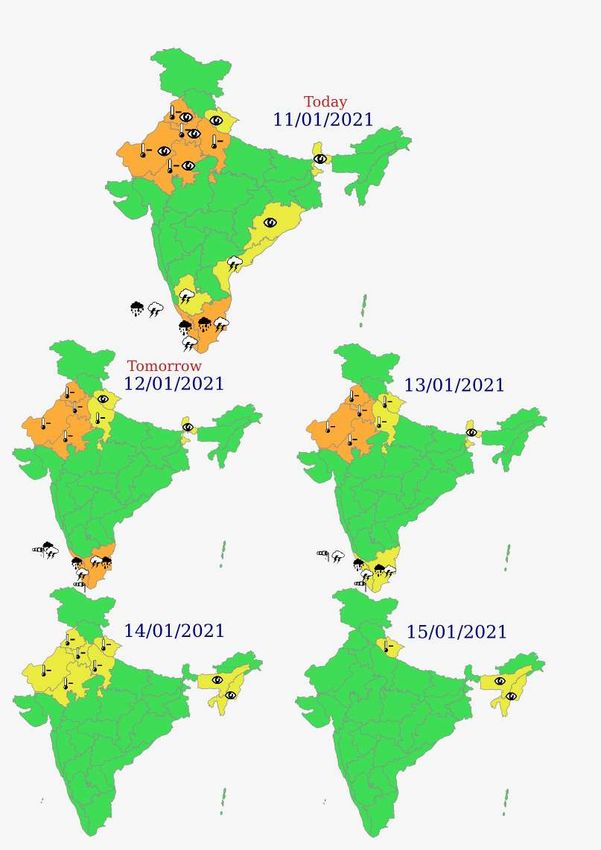
15 January (Day 5):♦ Dense fog conditions at isolated places likely over Assam & Meghalaya and Nagaland, Manipur,
Mizoram & Tripura.
♦ Cold Day conditions in isolated pockets likely over Uttarakhand.

                             * Red color warning does not mean "Red Alert" Red color warning means "Take Action".
                       Forecast and Warning for any day is valid from 0830 hours IST of day till 0830 hours IST of next day
                        For more details kindly visit www.imd.gov.in or contact : +91 11 24631913, 24643965, 24629798
                                                        (Service to the Nation since 1875)
Impact expected and action suggested due to cold day/severe cold day conditions over
Punjab, Haryana, Chandigarh & Delhi, northwest Uttar Pradesh and north Rajasthan during
next 3 days and cold wave/severe cold wave conditions over Punjab, Haryana, Chandigarh &
Delhi, northwest Uttar Pradesh and north Rajasthan during next 3-4 days.
                                                      Impact expected:

   •   An increased likelihood of various illnesses like flu, running/ stuffy nose or nosebleed, which
       usually set in or get aggravated due to prolonged exposure to cold.
   •   Do not ignore shivering. It is the first sign that the body is losing heat. Get Indoors.
   •   Frostbite can occur due to prolonged exposure to cold. The skin turns pale, hard and numb
       and eventually black blisters appear on exposed body parts such as fingers, toes, nose and or
       earlobes. Severe frostbite needs immediate medical attention and treatment.
   •   Impact on agriculture, crop, livestock, water supply, transport and power sector at some
       places.

                                                      Action suggested:

       •   Wear several layers of loose fitting, light weight; warm woolen clothing.
       •   Cover your head, neck, hands and toes adequately as majority of heat loss occurs through
           these body parts. Wear several layers of loose fitting, light weight; warm woolen clothing
           rather than one layer of heavy cloth.
       •   Eat vitamin-C rich fruits & vegetable and drink sufficient fluids preferably warm fluids to
           maintain adequate immunity.
       •   Avoid or limit outdoor activities.
       •   Keep dry, if wet, change cloths immediately to prevent loss of body heat. Wear
           insulated/waterproof shoes.
       •   Warm the affected area of the body slowly with lukewarm water; do not rub the skin
           vigorously.
       •   If the affected skin area turns black, immediately consult a doctor.
       •   Maintain ventilation while using Heaters to avoid inhaling toxic fumes.
       •   Take safety measures while using electrical and gas heating devices.
       •   Extreme care needed for vulnerable people.
       •   Seek medical attention as soon as possible for someone suffering from frostbite/
           Hypothermia.
       •   Protect livestock from cold weather.
       •   (For details kindly refer NDMA guidelines:
           https://ndma.gov.in/Resources/awareness/Cold_Wave )

                          * Red color warning does not mean "Red Alert" Red color warning means "Take Action".
                    Forecast and Warning for any day is valid from 0830 hours IST of day till 0830 hours IST of next day
                     For more details kindly visit www.imd.gov.in or contact : +91 11 24631913, 24643965, 24629798
                                                     (Service to the Nation since 1875)
Impact expected and action suggested due to Dense Fog over Punjab, Haryana, Chandigarh &
Delhi and north Rajasthan on morning hours of 12th January, 2021.
Impact expected:
Transport and Aviation:
May affect some airports, highways and railway routes in the areas of met- sub-division.
Ferry services also to be affected.
Difficult driving conditions with slower journey times.
Some road traffic collisions
Power Sector:
Chances of Tripping of Power lines in the very dense fog routes
Human Health:
Lung related health impacts: Dense fog contains particulate matter and other pollutants and in
case exposed it gets lodged in the lungs, clogging them and decreasing their functional capacity
which increases episodes of wheezing, coughing and shortness of breath
Impact on people having asthma bronchitis: Long time exposure to dense fog may cause respiratory
problem for people having asthma bronchitis and other lung related health problems.
Causes Eye Irritation: Dense fog contains pollutions of various types and these Pollutants in the air if
exposed may tend to irritate the membranes of the eye causing various infections leading to
redness or swelling of the eye.
Action suggested:
Transport and Aviation:
Careful while driving or outing through any transport.
Use fog lights during driving.
Be touch with airlines and Railway and State transport for scheduled of your journey.
Power Sector:
Keep Maintenance Team ready.
Human Health: Avoid outing until unless emergency and cover the face.
* Red color warning does not mean "Red Alert" Red color warning means "Take Action".
Forecast and Warning for any day is valid from 0830 hours IST of day till 0830 hours IST of next day
 For more details kindly visit www.imd.gov.in or contact : +91 11 24631913, 24643965, 24629798
(Service to the Nation since 1875)* Red color warning does not mean "Red Alert" Red color warning means "Take Action".
Forecast and Warning for any day is valid from 0830 hours IST of day till 0830 hours IST of next day
For more details kindly visit www.imd.gov.in or contact : +91 11 24631913, 24643965, 24629798
(Service to the Nation since 1875)Kindly download MAUSAM APP for location specific forecast & warning, MEGHDOOT APP for
Agromet advisory and DAMINI APP for Lightning Warning & visit state MC/RMC websites for
district wise warning.
* Red color warning does not mean "Red Alert" Red color warning means "Take Action".
Forecast and Warning for any day is valid from 0830 hours IST of day till 0830 hours IST of next day
For more details kindly visit www.imd.gov.in or contact : +91 11 24631913, 24643965, 24629798
(Service to the Nation since 1875)You can also read