Feasibility Study - Lincoln Downs Recreation Reserve Developed by the Mangawhai Tracks Charitable Trust As a result of this study the Tracks Trust ...
←
→
Page content transcription
If your browser does not render page correctly, please read the page content below
1

Feasibility Study – Lincoln Downs Recreation Reserve
Developed by the Mangawhai Tracks Charitable Trust

As a result of this study the Tracks Trust asks the Council to:
   1. Agree to designate the Lincoln Downs Farm bush block a recreation
      reserve.
   2. Agree and survey the boundaries of the reserve.
   3. Agree and identify access to the reserve.
   4. Identify the Mangawhai Tracks Trust as the lead community
      organisation to progress the design and construction of walking and
      mountain biking tracks within the reserve, and revegetation of old
      pasture.

1. Overview of Organisation
Organisation Purpose
The Tracks Trust was born out of the Mangawhai Walking Weekend and the need to
develop new walking opportunities in the Mangawhai area. While the Trust has been
focused on walking tracks it explicitly states in its constitution that the construction of cycle
trails and mountain bike tracks are central to its primary objective.
Organisation contact details
Dr Gordon Hosking (Chair), PO Box 169, Mangawhai 0540. gordon.hosking@xtra.co.nz
0274586500
www.mangawhaitracks.com
Legal entity
Charitable Trust registered with the Charities Commission No. CC46468
GST
Not registered for GST
Voluntary Organisation
The Tracks Trust is an entirely voluntary organisation with no paid members and no
operating expenditure. As an example of the work of the Trust Forty six active volunteers
contributed over 1600 hours work in the June 2018 year. It has operated since 2008. Its
primary income source is funds raised from the wine and food event associated with the
Mangawhai Walking Weekend and averages $10,000 per year. Donations have also been
received in the past year from the Opportunity Factory and Tara Iti Golf.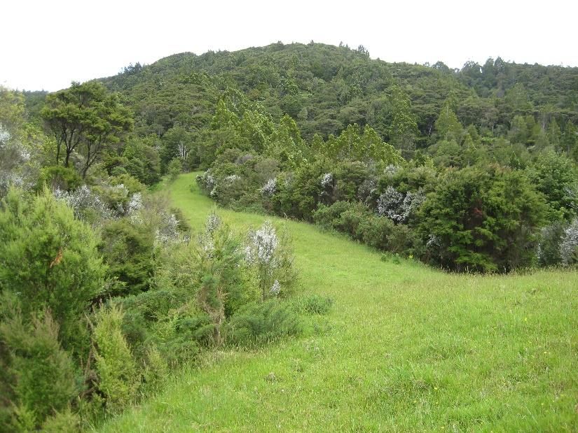
2

Appendix 1 illustrates the scope and achievements of the Trust since its inception in 2008.

2. Project Plan
Project description
The bush block of the Council owned Lincoln Downs farm on Brown Road covers about a
120 ha (to be confirmed) extending from the farmed area up the south eastern face of the
Brynderwyns (Figure 1).

Figure 1. Lincoln Downs farm bush block (unconfirmed area 120ha).

The lower slopes have extensive areas of gorse which is rapidly re-colonising grassed areas
on the ridges as well as pasture on the lower slopes. The valleys and higher elevations
contain impressive forest remnants and secondary forest growth (Figure 2).

Figure 2. Upper slopes previously grazed area has largely
          been invaded by gorse since image taken.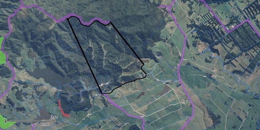
3
The area has been extensively tracked in the past for farming purposes, much of which has
been reclaimed by both forest and gorse. The north western part of the block adjoins an
unformed public road providing potential access to the wider Brynderwyn range. The block
has little value to the farming enterprise but in both topography and vegetation is a perfect
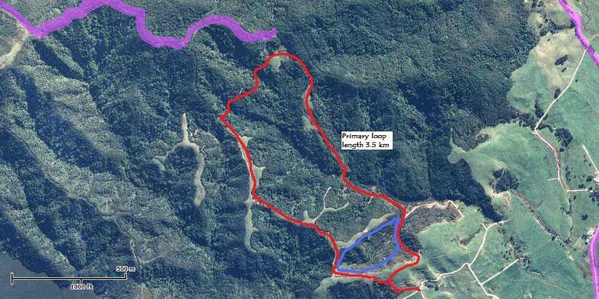
area for the development of a dedicated mountain bike park and walking tracks (Figure 3).
The Trust requires the Council to establish the area as a recreation reserve so that the
project can proceed with assurance of tenure.
Figure 3. Potential primary MTB loop track with unformed public road above.
How will the project be developed?
The Tracks Trust will lead the initiative and contribute labour as appropriate to its
development. It is proposed that the MTB park be constructed to a standard suitable for
national competition and to this end a professional design organisation, such as Southstar
Trails, would be contracted to develop the design and supervise construction. Key issues
include:
Use of existing historical farm tracks
Separation of MTB and walking tracks
Agreed access to the reserve
Revegetation of hill pasture and gorse areas
The Trust, with its extensive experience, would take responsibility for the development of
walking tracks using its volunteer labour.
Use of existing tracks. This would be a key issue for the design team but would not be
allowed to compromise track quality.
Separation of walking and MTB tracks. It is considered essential the two track types are
completely separate. The southern part of the block is considered best for walking tracks
with good native forest and some key existing tracks extending to the ridge. The northern
section with its greater areas of reverting gorse and scrub, but good native forest at higher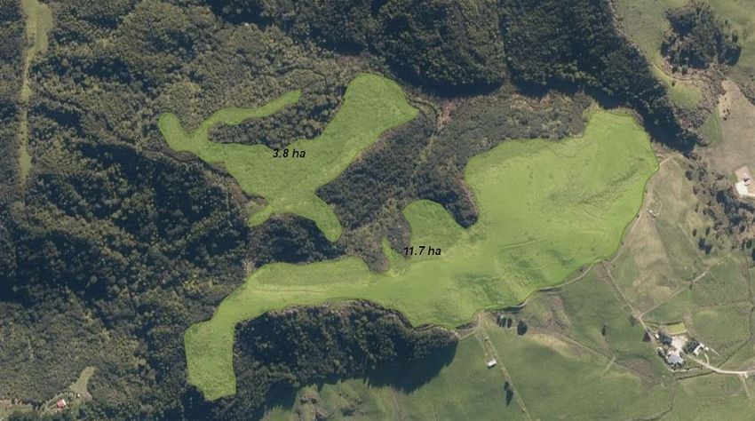
4
elevations, has excellent contour for the development of MTB tracks. However, integration
of the track areas will be considered.
Access. There are two options for access, from Wonderview Road via western boundary
race, and Brown Road via the central farm access (Appendix 2). The former has the
advantage of extensive parking along Wonderview Road and access which does not intrude
into the active farming area. Its main disadvantage is its length and extensive reforming and
drainage. The Brown Road access is much shorter and is already well formed but does pass
farm buildings and houses.
Critical stages. There are three critical issues which need to be addressed to get the project
underway:
Conferring of reserve status on the bush block by Council
Survey of reserve area including access
Identification of funding for Stage 1 (design, access, ground survey, MTB primary
track)
The designation of reserve status on the bush block is fundamental for the Trust to invest
effort in seeking funding, developing an operational plan, and investing the huge number of
volunteer hours which will be needed on the ground. It is also critical that the area
designated include suitable public access, and the lower hill slopes down to the main
western race. The development of this feasibility study will provide an estimate of the costs
involved in getting the project off the ground.
What cross-section of the community will benefit from this Project?
The Project will have benefits to almost all sectors of the community. Specifically it will
provide:
Recreational opportunities for MTB enthusiasts of all ages
Walking opportunities for individuals, families and organisations
Encouragement of active lifestyle and associated health benefits for all ages
Economic benefits to the business and tourism community
Reach across the eastern part of the region and to some degree beyond
Worthwhile opportunity for involvement of volunteer community
Access to outstanding native forest environment for all community members
Ensuring the long-term retention of a significant area of native forest
Rehabilitation of significant area of rough pasture and reverting gorse areas
As well as the above benefits to communities in the KDC catchment area, the project will
provide recreational opportunities which will inevitably prove attractive to visitors from
Whangarei, Auckland and beyond. The MTB component compliments the cycle trails
proposed for the wider Kaipara region.
How does your Project impact the community’s Four Well-beings?
Economic. The proposed high quality MTB/walking recreation area will attract visitors from
the wider Northland region as well as tourists from further afield. Direct experience of
walking groups venturing north from Auckland, due to closure of local forests to prevent the
5

spread of kauri dieback, can be seen with the Tanekaha Track complex which has been
developed by the Trust volunteers since 2011. In excess of 6000 walkers have used the site
over the last 12 months and walking groups from both Auckland and Whangarei are actively
seeking new opportunities.
A recent economic impact study of mountain biking in Rotorua (Michael Connell & Assocs,
July 2018) found between $30m and $50m is contributed by riders to the local economy.
This spend contributes an estimated 200 to 350 FTE jobs which equates to $10m to $20m in
income. The study did not capture the benefits brought by other recreational use such as
walkers and runners, nor the health and well-being benefits of the forest. While we do not
pretend the proposed project will meet these levels of economic benefits it is undeniable
significant economic benefits will flow to the local community from the project.
The project will also offer the opportunity for extensive native forest restoration with the
accrual of carbon credits and potential to be supported by the billion trees project. A
conservative area estimate of 15 ha could accommodate between 50,000 and 150,000 trees
dependent on spacing and species, with a nurse crop of manuka for honey production a
potential option (Figure 4). On average New Zealand native forests store 210 tonnes of
carbon per hectare at maturity. Dr David Bergin, foremost authority on native forest
rehabilitation would be engaged to develop an appropriate planting plan for the site.

Figure 4. Potential planting area currently in gorse or grass.
Cultural. While the cultural benefits will be limited due to the lack of significant cultural
sites on the proposed land, the drawing of visitors to the general area will provide exposure
to the significant cultural sites in the wider area.
Environmental. The mid to upper slopes of the bush block contain significant areas of native
forest and form part of the highly valued southern slopes of the Brynderwyn Hills. Past
development efforts has shown the local community is strongly opposed to the loss of this
6
forest landscape. A survey of the Tanekaha bush, also on the southern slopes of the
Brynderwyns, similar in composition to the bush block, identified more than 146 plant
species (Young 2018). The proposed project would provide permanent protection, along
with public access, to this botanically diverse forest typical of the southern slope of the
Brynderwyn Hills. Planting of the gorse covered lower slopes and rough pasture would not
only enhance the site for walking and cycling but would also contribute to both biodiversity
and to the Government’s climate change strategy. The very low incidence of kauri within the
block has the added advantage of low risk of closure due to the kauri dieback control
strategy.
Social. The provision of significant recreational facilities within easy reach of local
communities encourages social interaction and well-being. The proposed project not only
provides social benefits to future users but also to the community of volunteers involved in
its development. Walking and MTB groups are always looking for new and interesting
challenges to keep their members motivated. Access to walking and MTB tracks in a natural
forest environment will be highly valued. A dedicated area of MTB trails would complement
regional trails being promoted by Council and Nga Haerenga New Zealand Cycle Trail.
How does the Project link to Policy Criteria?
The project links to the following Policy Criteria:
Revenue and Financing Policy. The project contributes directly to improved open
spaces and recreational opportunities, benefits a wide sector of the community, with
benefits accruing in the short term, and a community group willing and able to lead
the initiative. The activity qualifies as high priority under the Revenue and Financing
Policy criteria.
Significance and Engagement Policy. With the Council already owning the land and
the block in question contributing little to the Council’s activities the designation of
reserve status and agreement to allow the project to proceed should be considered
of very low significance under this policy.
Development Contributions Policy. The proposed project clearly addresses the aim
of providing increased community facilities resulting from the demands of growth
and development across the region. The project has particular significance for its
reach in addressing this issue, a reach which is much wider than just the high growth
area of Mangawhai.
Financial Contributions Policy. The proposed project addresses the need to protect
significant natural features and with expected native forest rehabilitation as part of
the project is expected to enhance these values. It also conforms to the
establishment of reserves and public open space areas with the addition of a
significant area of native forest open for public enjoyment.
How does the Project link to community outcomes?
A district with strong and welcoming communities. The track record of the Tracks
Trust speaks for itself in the development and promotion of walking opportunities
both in the Brynderwyns and in the Mangawhai urban area. The Trust works closely
7
with Council, DoC, and the annual Walking Weekend to motivate volunteers and
welcome walkers to experience the products of their efforts.
A trusted Council making good decisions for the future. The proposed project is
forward looking in preserving a significant open space for future generations. A
strength of the project is the Trust’s strong relationship with Council and its staff
with well-developed two way consultation on activities of mutual interest.
A district with plenty of active outdoor opportunities. The project involves a strong
community partnership clearly focussed on “Protecting and enhancing our natural
assets and open space”.
What is the community demand for the Project?
Since first proposing the project in 2013 the Tracks Trust has enjoyed continued strong
community support for the project. A recent facebook posting attracted over 1400
responses overwhelmingly in its favour. The small and unsatisfactory MTB tracks in the
Mangawhai Community Park attract high use despite their unsuitable sand base.
Does the Trust own or manage any key assets?
The Trust has developed and manages an extensive network of walking tracks in a 300ha
DoC reserve on the south side of the Brynderwyn Hills. Management involves the building
and maintenance of over 12km of walking tracks, signage, parking, and access. The Trust
successfully applied for $23K from Walking Access NZ to build a swing bridge providing the
primary access to the reserve, a structure now vested in Council. The Trust also manages
and maintains a number of walkways in the Mangawhai urban area including in partnership
with developers.
Does the Trust have the capacity to undertake this project?
The Tracks Trust volunteer workers have successfully undertaken a wide range of projects
over the past 6 years (Appendix 1.) including:
Walking and cycling tracks in the Mangawhai Community Park
Tracks on Council reserve land (Goldschmidt, Devon to Lincoln St., Back Bay)
Tracks in new subdivisions (Parkview Waters, Sands)
Tracks in Regional Parks (Te Arai)
Tracks in DoC reserve land (Tanekaha complex)
Much effort in the past 5 years has been focused on the development of the Tanekaha
Track complex in the DoC reserve north of King Road. This work is now at an end with only
track maintenance continuing. Although a number of smaller projects are underway or
pending, a major new project is timely and would provide new motivation and cohesion to
the group, many of which find the social interaction involved in the work its greatest
reward.8
3. The Future
What will be different as a result of this Business Plan?
It is estimated that completion of Stage 1 of this project (primary MTB track open, one
major walking track complete, 15 ha of native plantings established, and access upgraded)
will be 3 years from being given permission to proceed. At the end of 3 years there will be:
A long term strategy and plan for development of the whole block
An all-weather metaled access track from either Wonderview Rd. or Brown Rd. to
the site
A dedicated parking area
A fully functional dedicated MTB track completed to the highest standard
A fully functional walking track terminating at the Brynderwyn ridge and linked to
the Brynderwyn Walkway
An automated monitoring system for usage
A toilet facility designed and consented
A national profile of the site and its future development through the Trust’s website,
Council website, Walking NZ website, and MTB websites.
An extensive area of native forest established
Our aim by the end of 3 years is to make the Lincoln Downs recreation area a destination for
mountain bikers and walkers especially from Auckland north, but also for visitors from wider
New Zealand and overseas.
4. Action Plans
Objectives Actions/milestones How will you know the Person responsible Completion
action has been achieved for ensuring Date
or completed completion
Achieve Reserve Council formally Advice from Council Gordon Hosking & February
status for the agreed to reserve Council 2019
site status
Agreed Surveyed access and Council/Trust agreed Gordon Hosking & May 2019
boundaries boundaries to block survey plan Council staff
Stage 1 MTB Professional design Design agreed with Trust, Gordon Hosking June 2019
track design and mark out of MTB documented, and ground
track marked
Stage 1 walking Design and mark out Track marked on the Trustee Greg Stump June 2019
track design walking track to ground ready for
Brynderwyn ridge construction to begin
Re vegetation Re vegetation plan Plan reviewed by Trustees Gordon Hosking August
plan and costing for and Council 2019
development grass/gorse area
Access track Upgrade drainage Inspection of access track Trustee Mike Hay & December
completed and surface of access by Trustees and Council Council staff 2019
track and install any staff
required bike
bypasses9
Parking area Provide adequate Parking area gravelled and Trustee Mike Hay & December
developed parking area at marked Council staff 2019
access point
Re vegetation At least 5ha of Plantings inspected by Gordon Hosking September
underway grass/gorse planted Trustees 2020
MTB track MTB track ready for Trial riding and evaluation Gordon Hosking December
completed use including carried out 2020
boardwalks/bridges
Walking track Walking track formed Invitation opening and Mike Hay and Greg December
completed including steps and walk Stump 2020
boardwalks
Formal opening Stage 1 complete and Invitees attend opening Tracks Trustees & February
formal opening Council 2021
undertaken
5 year Design of future MTB Formal document agreed Gordon Hosking June 2021
development and walking tracks between Council and Trust
plan completed agreed
5. People Plan
Description
Who will be involved Leadership and primary labour contribution to the project will
from the community in come from the Tracks Trust. With over 40 active volunteers
the project? working on projects every Friday, on the ground support will
not be a problem. In addition the Auckland MTB club has
offered to join working parties. We are confident the project
will attract additional volunteer support.
What will be the While professional input will be required for the design and
voluntary contribution to construction of the MTB tracks all manual labour will be
the project? provided by volunteers. Construction of walking tracks will be
entirely by volunteers. It is expected 80% of input to the
project will be by volunteers. The Tracks Trust is confident it
can raise and contribute significant funds to the project.
How many volunteer In 2018 46 active Tracks Trust volunteers contributed over
and/or machine hours 1600 hours in track development work, a level expected to
are being donated? continue or increase. A North Shore drainage firm has
volunteered a digger and operator free of charge to the
project.
6. Working with partner groups
The Tracks Trust will be the primary driver and contributor to the project but will work with
Southstar Trails in the design and construction of the MTB tracks and also expects to work
with volunteers from Auckland MTB groups. Dr David Bergin would advise on the forest
rehabilitation planting and revegetation of pasture and gorse areas.10
7. Capital Works Projects and Budgets
Expenditure ($) Stage 1 Stage 2 Stage 3 Total
Survey block & access 6,000
Access upgrade 30,000
Geotechnical report 5,000
MTB track design 15,000 10,000 10,000
MTB track construction 70,000 70,000 50,000
Boardwalk/step materials 6,000 6,000 5,000
Equipment hire 5,000 5,000 5,000
2 X Wilderness Toilets 20,000
Storage facility 10,000
Re vegetation stage 1 20,000
Total Capital Expenditure 137,000 111,000 100,000 348,000
8. Risk Management
The Tracks Trust has detailed Risk Management Plan (Appendix 3) which includes policy and
procedures covering health and safety, financial, and reputational risks. The Trust maintains
a risk register, incident register, and attendance register covering all its activities.
8.1 Operations
Risk description Likelihood Impact Mitigations
Reserve status of site Low High Seek alternative site/ discuss with other
landowners.
Public access to site Low High Alternative access possible
Access for track design Low High Trust to clear gorse/weeds prior to
design stage.
Availability of track Low Moderate Hand construction and alternative
building machinery machine sourcing.
Insufficient labour Low Low Longer build period.
8.2 Financials
Risk description Likelihood Impact Mitigations
Failure to obtain KDC support low High Lobby Councillors and staff and
present a convincing business
case.
Failure to obtain third party low High Identify a range of potential
funding funders and clarify their funding
strategies
Tracks Trust resources Low High Ring fence existing resources for
inadequate to attract third project.
party support11
References
Michael Connell & Assocs. 2018. Mountain biking in Whakarewarewa Forest. Economic
impact study. Report to Rotorua Lakes Council. 31pp.
Young, Maureen. 2018. Checklist of indigenous vascular plants. Tanekaha Falls/Puriri Track,
DoC Reserve, King Rd., Mangawhai.4pp.
Appendix 1.
Walking Track Priority Plan 1/11/2012 as at 1/12/2018
Track Current status Work required Time frame Progress
Goldschmidt Complete except for Boardwalk across wetland between Pearl Boardwalk as funds available. Completed
wetland walkway and Cullen. Signage Cullen Rd end and track Signage ASAP aim to compete
Priority 1 upgrade and signage. markers. by 1 August.
Goldschmidt Track formed and Additional steps (30 – 40) and track Steps to be completed by June 30. Completed
Heads Loop some steps built. markers. Track markers once available.
Priority 1
Paul’s Track/ Complete but some Boardwalk upgrade southern end of track Boardwalk when material available. Markers complete
Last of Summer boardwalk upgrade currently using pallets. Signage at beginning Track markers when
Wine required plus signage. of track and track markers. available.
Priority 2
MAZ Link Track Track formed and steps Three more steps required. Access from Before end of year Complete
installed. MAZ to be identified and signage installed.
Cross-over with bike track to be
Priority 1 constructed.
Sandstone Gully Walk Scouted to link Last of Track to be formed, no steps required. Before end of year Completed
Priority 2 Summer Wine and Paul’s Signage needed
Track.
Jordon St – Harbour This paper road Heavy gorse infestation would Clarify actual position of Developer has
would create a require some effort. Neighbours road and verify GPS data completed
Priority 2 further link in the have shown some interest in already obtained.
round harbour track progressing this access.
Old Waipu Rd. Paper road with good Track position on paper road with Track to be reassessed in Preliminary
access from Cove Rd. reference to wet areas. Style winter to identify wet areas assessment
Unformed from access, drainage, gorse clearing. and track
Priority 3 Village end. Boardwalks required. position.
Moir Pt Not accessible Realignment of first section off Discussion with Christian Made redundant
driveway. Fencing to exclude stock Camp by Mangawhai
and removal of existing fence. re fencing but realignment Point development
Access to harbour along paper can
Priority 2 road. proceed immediately.
Locate paper roads from
harbour to avoid Pt at high
tide.
Te Arai Regional Park Construct walk to
sand lakes for WW
Brynderwyn Access Agreement needed Identify track position and bridge Position across private land, Completed and
on track location in crossing point. Design of bridge easement or paper road, track open.
relation to private and construction, locate and and bridge location by end
Priority 1 land. establish track. of June. Bridge design and
construction before June
2012.12
Tanekaha Track car
park
Forest Track
Falls Track
Puriri Track
Botanical Track
Parkview Waters Working with
Track developer Bruce
Ogilvy
Back Bay track
upgrade
Brown’s Road Some evaluation of Develop a management plan for Once protection assured No progress
Farm bush area current tracking but site incorporating walking and develop
no further progress cycling. Baseline information of draft management plan
until protection aerial photography and mapping of within
Priority 3 assured. existing tracks. 6 months. Awaiting Council
action before progressing.
See also MTB below.
Mangawhai A number of tracks Baseline data for management plan If work supported by KDC Basic ecological
Park and amenities needs to be produced, including proceed immediately to assessment
developed or under registration of aerial photos, develop completed. Link
construction. mapping of existing tracks and baseline information. tracks Info centre
Priority 2 facilities, and vegetation cover. to Pioneer village
underway.
Thelma Rd Track
Round Estuary Sections range from Identify status of all sectors and Back Bay to Pearson St in Awaiting
Walkway complete to semi- prioritise sections for development, Environment Court. Picnic resolution in Court.
complete to non- negotiation, etc Bay to camp ground under
Priority 1 existent. consideration
Estuary Drive Sections need 1. Estuary drive to Moir Pt Rd. Discussions with developers Completed
foreshore to Lincoln completion and Discuss with Park View, gate access by end of July.
Rd linking. and extend track to Moir Pt Rd. Locate Devon St end and
2. Establish track Moir Pt Rd to track alignment by end of
Devon St. June.
3. Develop and upgrade Devon St Form Devon to Cheviot st
Priority 1 & to Lincoln St section. section
Priority 2 4. Estuary Drive down to foreshore as priority.
Identify foreshore section
Resources Posts Posts for track markers June – July Obtained
Timber Timber boardwalks in Mangawhai November In hand
Park
Imagery Mangawhai Park November No progress
Signs Brynderwyn Track August In place
Signs Major sign for Goldschmidt Track June In place
Mountain Bike Track Development 29/10/2011 as at 1/12/2018
Toddler’s Track Partially marked at Clearing and ensuring slight grades only By early 2012 Completed
western end of MAZ and complete marking. Need for wide
clearing and forming.
Family Track Area identified at Requires route marking, track clearing By early 2012 Complete
eastern end of MAZ and forming quite wide.
beneath eucalypts13
for extensive rolling
network.
Family Track 2 More difficult track Cleared but not sprayed (2 tracks) and By late 2012 Two tracks
at western end of further track under development completed
MAZ
Brown’s Road Farm In conjunction with See under Walking Tracks Council action needed No Progress
bush area walking tracks above.
Intermediate Track Under development Complete clearing and forming to Temporary loop Completed
on ridge north of lookout point and provide temporary completed by
MAZ loop down walking track. Mark and Christmas 2011.
complete western end to link into Warning signs on
Toddler’s Track. walk/ride section.
Competition Track Permission to Expert input to design and establishment Long term probably 2 No Progress
proceed with KDC of general route years away
Appendix 2.
Access options
There are two options for access to the bush block, from Wonderview Road and from Brown
Road. The former has the advantage of extensive parking along Wonderview Road and
access which does not intrude into the active farming area. Its main disadvantage is its
length and extensive reforming and drainage required. The Brown Road access is much
shorter and is already well formed but does pass farm buildings and houses (Figure 5). Any
access must provide for heavy transport to the site but public parking should be confined to
Wonderview Road or inside the entry from Brown Road.
Figure 5. The two potential access options.14
Appendix 3.
Mangawhai Tracks Charitable Trust – Risk Management
Preamble
The Mangawhai Tracks Charitable Trust is a volunteer organisation dedicated to the
development and maintenance of walking and cycling tracks in the wider Mangawhai area.
It largely consists of retired folk, many over 70 years of age, undertaking often demanding
physical activity in isolated areas such as the bush clad southern slopes of the Brynderwyn
Hills. This combination of age, physical demands, and isolation demand the development of
an effective risk management strategy.
Risk Management Policy - General
Purpose: The Trust recognises that the nature of our activities, the age structure of our
volunteers, and the environment in which we operate, exposes us to risk. To ensure the
greatest safety of our volunteers and the continued viability of the Trust we will:
Use our combined knowledge and experience to identify our risks.
Determine the likely impact of these risks and prioritise their importance.
Identify and implement strategies to minimise risk.
Record all risks in a Risk Register and review in relation to risk management.
Undertake an annual review of our risk management policy and its associated
strategies.
Prudently manage our financial resources and maintain the trust of our sponsors.
Provide a high standard of facilities to our stakeholders.
Roles and responsibilities: While the Chair of the Trust will take overall responsibility for
risk management, the Trustees will:
Review the policy and its associated procedures at least annually and following any
serious incident.
Review the Risk Register at least annually.
Identify activity co-ordinators and their responsibilities.
Ensure all incidents are entered in the Incident Register.
Performance Indicators: The effectiveness of the Trust’s risk management will be
determined by:15
Annual review of policy and associated procedures being undertaken.
Annual review of Risk Register being undertaken.
Effective reporting and recording of incidents.
Change in policy and/or procedures resulting from incident reporting.
Associated documents:
Risk Management Procedures
Risk Register
Incident Register (held in attendance book)
Date established: 29/05/17 Signature of Chairperson:
Date of next review: May 2018
Risk Management Procedures
A. Health and Safety Procedures:
Purpose: To help ensure the safety, health, and wellbeing of our volunteers while
working on Trust projects.
Safety:
A daily register of individuals actively working will be recorded.
H & S incidents will be recorded and entered on the Incident Register.
A comprehensive first aid kit will be available at the work face at all times.
The work team will be briefed on risks before work commences.
Working alone is not permitted except with express permission of the chair-
person.
Seasonal risks such as wasp/bee nests, wet slippery surfaces, high stream
levels will be identified.
Procedures for identified work risks:16
(a) Use of power tools:
Only experienced operators will use power tools such as weed eaters,
chainsaws, scrub cutters, and hedge trimmers.
Chain saws will only be used by approved volunteers.
Volunteers will not work in the immediate vicinity of power tool
operators.
Power tool operators must use the appropriate safety equipment.
(b) Weather:
Volunteers will not work in dangerous weather conditions such as
heavy rain and high wind.
Weather related risks will be specifically identified in pre-work
briefing.
Metservice weather for Whangarei (rain radar) useful.
(c) Volunteers under 16 years:
The Trust encourages the participation of young people but
recognises it has particular responsibility for their safety.
The work environment and activities of young volunteers will be
discussed with their parent/guardian prior to their involvement.
A mature volunteer will be nominated as a buddy for any young
volunteers.
Duty of care extends until young person is delivered back to pick-up
point and responsible adult.
Roles and Responsibilities:
Communication leader’s responsibilities:
Inform volunteers of proposed activities and responsibilities.
Team Co-ordinator’s responsibilities:
Decide if weather/conditions are suitable for a work session.
Complete attendance register on the day.
Provide H&S briefing before work commences.
Identify any first time participants.
Ensure appropriate clothing, footwear, tools.
Advise working time/exit time.
Encourage reporting of all incidents and log reports.
Ensure a mature volunteer is nominated as a buddy for any young volunteer.
Co-ordinator to ensure access to a mobile phone and a first aid kit.17
Volunteers’ responsibilities:
Ensure they work within their level of fitness and capability.
Ensure any weight carrying is within their capability.
Take care not endanger themselves or others.
Work only with tools they are experienced in using.
Wear suitable footwear.
Advise Co-ordinator of any incident, health concerns, safety issues.
B. Financial Risk
Purpose: To ensure the financial viability of the Trust.
Financial procedures:
A reserve fund sufficient to cover annual fixed commitments and the
completion of existing projects will be maintained
Support from multiple sources of funding will be sought.
A record of funders and potential funders will be maintained.
Disbursement of funds from the Trust will require two trustee signatories.
An annual financial review will be undertaken in accordance the Charities
Commission requirements.
Project funding:
New projects will be costed within a project plan.
Funding will be in place before major projects are initiated.
Funding will be disbursed only with formal Trustee agreement.
Responsibilities:
The trustees are responsible for ensuring the financial viability of the Trust.
The Treasurer is responsible for providing the Trust with the annual reporting
documents for auditing in accordance with the Charities Commission
requirements.
C. Reputational Risk:
Purpose: To ensure the Trust’s reputation remains beyond reproach through the
performance of its volunteers, the quality of its work and the support of its
stakeholders.
Reputational procedures:
Tracks are to be constructed to an appropriate quality.
High quality signage will be supplied and maintained.18
Contract work will only be undertaken where it can be delivered within
agreed time and cost constraints.
A positive media image will be maintained.
Respecting and caring for its volunteers and stakeholders.
Responsibilities:
The chair-person or his/her nominee will oversee the quality of the tracks
and signage.
The trust is responsible for approving any contract work undertaken.
The chair-person or his/her nominee will nominate a spokesperson to cover
all media releases.
All trustees and work co-ordinators will respect and care for all volunteers
and stakeholders.
Incident Register (Held in attendance book)
Mangawhai Tracks Charitable Trust – Risk Register
Calculating the risk score
Likelihood Impact: Score:
1. Rare. Very unlikely 1. Minor. Insignificant
2. Quite likely X 2. Quite serious =
3. Extremely likely 3. Extremely serious19
Identified Risks
Risk Date Risk Risk Management Status Risk
Logged Description Score Strategy Open/ Management
No. closed Update
1 29/05/17 Stream 7 Co-ordinator open
crossings/ H&S briefing.
Slippery Modify crossings
uneven
surfaces
2 29/05/17 Slippery 7 Co-ordinator open
tracks H&S briefing
3 29/05/17 Transporting 3 Identify weight, open
materials assess ability
4 29/05/17 Power tool 6 Approved operators open
use only, Co-ordinator
Briefing/monitoring
5 29/05/17 Hand tools 5 Co-ordinator briefing, open
Awareness raising
6 29/05/17 Individual 3 Allergies (e.g. wasps) open
health risks Medical issues/abilities
7 29/05/17 Financial 1 Insurance, trustee open
awarenessYou can also read