FIG'2018 IN ISTANBUL Orhan Ercan
←
→
Page content transcription
If your browser does not render page correctly, please read the page content below
Proceedings of the World Cadastre Summit 2015, Istanbul

                              FIG'2018 IN ISTANBUL
                                        Orhan Ercan

       PhD, The Turkish Chamber of Survey and Cadastre Engineers, Ankara, Turkey.

ABSTRACT

The Turkish Chamber of Survey and Cadastre Engineers (CSCE) is proudly honored to host
the XXVI FIG International Congress & General Assembly in Istanbul, Turkey, which will be
held between 06 and 11 May 2018. The CSCE has been an active member of the FIG since
1969. The CSCE will now host the 2018 FIG Congress & General Assembly in order to
provide a platform where scientists, experts, researchers, public and private sector
representatives active in the field of surveying will come together and share their professional
experiences, thoughts, recently implemented projects, applied methods and to-date
technologies. For raising a globe-wide awareness, disseminating information and promoting
modern developments, the event will comprise organization of technical excursions and
leisure trips for diversification purposes, as well. We strongly believe that Istanbul will
provide a world class venue for the delegates to undergo a cultural, technical, professional and
personal experience with a balanced activities program that will ensure the FIG2018 Congress
& General Assembly be a very successful event. Within the scope of FIG2018; along with
keynote speakers, oral presentations, private workshops and a special “Young Surveyors”
session will be held with participation of FIG members. Also an exhibition by the public and
private sector institutions will be open for all participants throughout the Congress.

Biography – Ph.D., He was from 1984-2007, a senior engineer at the General Directorate of Land
Registry and Cadastre in Turkey. He executed some of the World Bank`s Project, and worked as
executive staff at Turkish NSDI, CORS, TAKBİS Projects. Since 2007, he was involved in private
sector as company manager and freelancer both in Turkey and Libya. From 2001 to 2010 he was the
part-time lecturer at university. He was the member of scientific commission C of OEEPE in 1993-94
and member of FIG working group 5.4.3 in 1995. He is an active member of FIG Commission 7 and
Congress Director of FIG2018. Since 2012 he is the chair of International Affairs Commission of
Turkish Chamber of Survey and Cadastre Engineers.

                                                                                         1064 | P a g e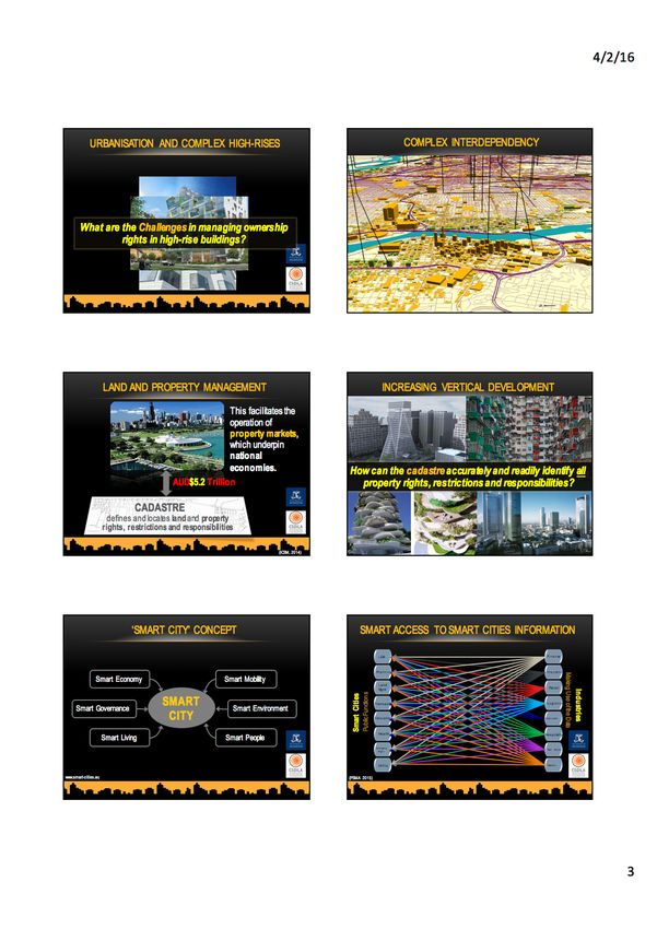
http://wcadastre.org

1065 | P a g e
Proceedings of the World Cadastre Summit 2015, Istanbul

                                     1066 | P a g e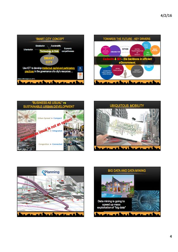
http://wcadastre.org
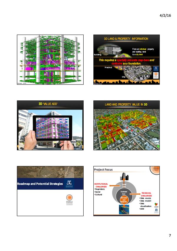
SMART FUTURE CITIES-THE ROLE OF 3D LAND AND
PROPERTY AND CADASTRE INFORMATION.
Abbas Rajabifard
Professor, FIEAust, FSSSI
Head, Department of Infrastructure Engineering University of Melbourne, Australia
ABSTRACT
There is now significant worldwide interest and momentum in utilising 3D digital
technologies to develop systems better equipped for managing the complexity of urban
environments, leveraging the volumes of information being generated by cities, and engaging
communities of interest to realise smart future cities. This presents challenges and
opportunities for many of the statutory systems that currently administer accurate core land
administration data (development, use, value and tenure). How does the cadastre deal with an
urban environment that is increasingly populated and structurally complex? In our drive
towards a knowledge-based era, cadastres can play a special role in generating new
connections between wider society, across state boundaries, and in supporting the delivery of
other national visions, digital economy, foundation datasets and smart cities. The realisation
of 3D cadastres, and indeed, to realise cadastres that will be sustainable into the future,
requires the consideration of how the needs of current users should be balanced against the
potential needs of future users. We need to accommodate the needs and opportunities of
future cities and consider what must be done to ensure institutional sustainability. This
presentation will discuss the drivers, challenges and opportunities for the geospatial and
cadastre industries and relevant professions in evolving cadastres to support smart future
cities. It will also discuss roadblocks and potential future directions and actions required from
government, industry and academia to achieve smarter cities using 3D cadastres identified at a
recent international symposium on future cities and 3D cadastre. This symposium was
conducted by the Centre for SDIs and Land Administration at the University of Melbourne in
February 2015, which aimed to provide an opportunity for the exchange of knowledge, ideas,
experience and practices around this highly topical issue. This presentation is also based on
the research by the author, his team and a range of industry partners titled ‘Land and Property
Information in 3D’.
Biography – Head of Department of Infrastructure Engineering at The University of Melbourne. He is
also Director of the Centre for Spatial Data Infrastructures & Land Administration. He was President
of the GSDI Association; Vice Chair of Working Group 3 of the United Nations supported Permanent
Committee on GIS Infrastructure for Asia and the Pacific, is a member of ICA-Spatial Data Standard
Commission, and is a member of Victorian Spatial Council. He has active research in the areas of
SDI, Land Administration and land management, spatial enabled government and societies, smart
cities, 3D platforms and virtual jurisdictions. He had published broadly on SDI, land administration,
GIS and spatial data management.
1067 | P a g e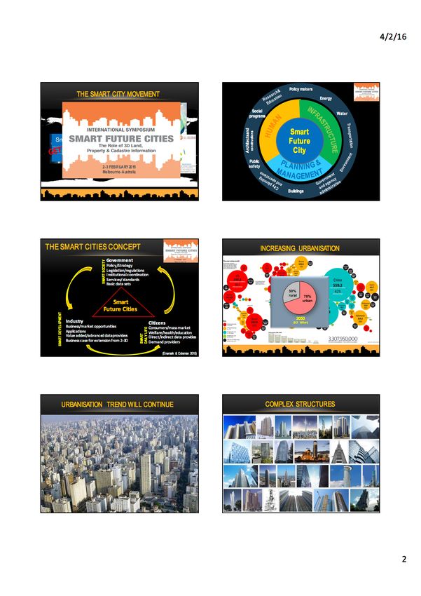
Proceedings of the World Cadastre Summit 2015, Istanbul

                                     1068 | P a g e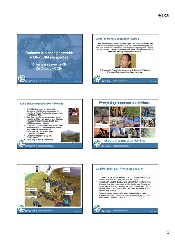
http://wcadastre.org

1069 | P a g e
Proceedings of the World Cadastre Summit 2015, Istanbul

                                     1070 | P a g e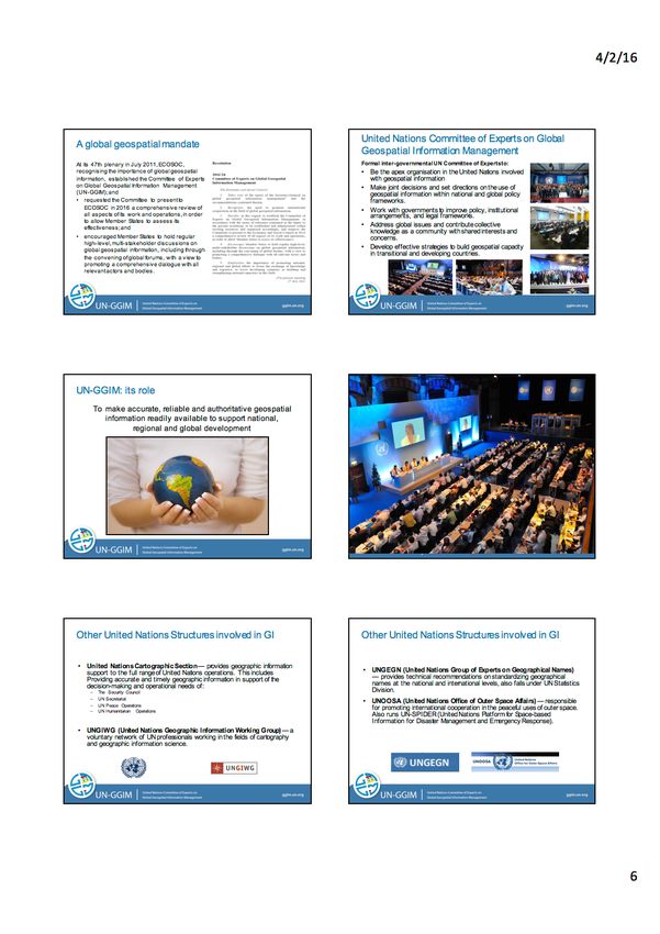
http://wcadastre.org

1071 | P a g e
Proceedings of the World Cadastre Summit 2015, Istanbul

                                     1072 | P a g e
http://wcadastre.org

1073 | P a g e
Proceedings of the World Cadastre Summit 2015, Istanbul

                                     1074 | P a g e
http://wcadastre.org 1075 | P a g e
Proceedings of the World Cadastre Summit 2015, Istanbul

                                     1076 | P a g e
http://wcadastre.org
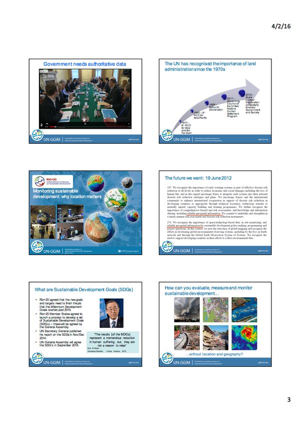
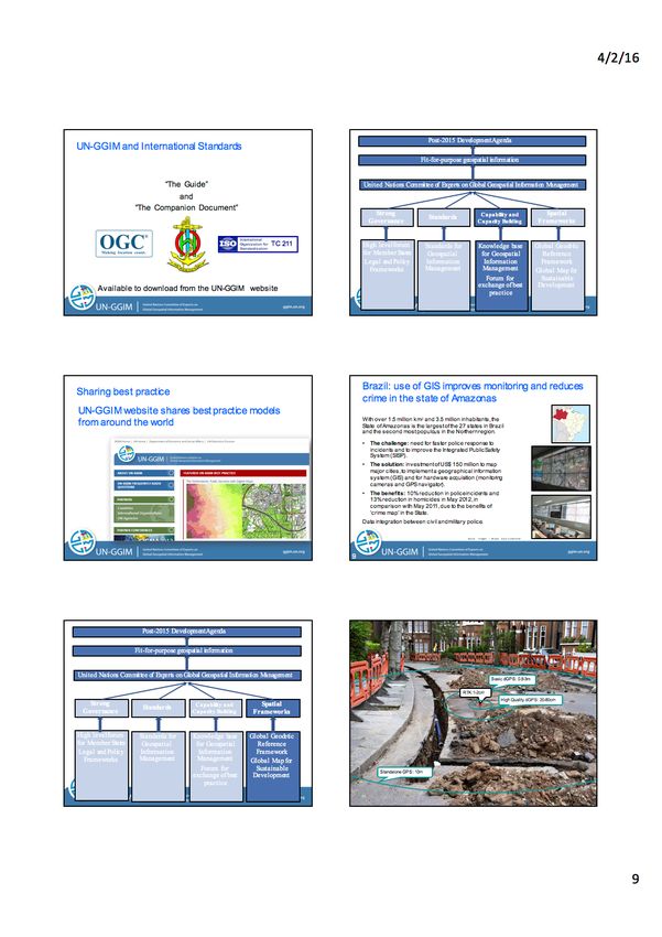
CADASTRE IN A CHANGING WORLD: A UN-GGIM
PERSPECTIVE
Vanessa Lawrence
PhD, Co-Chair of United Nations Committee of Experts of Global Geospatial Information
Management Initiative, UK
ABSTRACT
The Economic and Social Council of the UN (ECOSOC) established the United Nations
Committee of Experts on Global Geospatial Information Management (UN-GGIM) in 2011.
It was established to play a leading role in setting the agenda for the development of global
geospatial information and to promote its use to address key global challenges. Its aim is to
provide a forum to liaise and co-ordinate geospatial information activities among UN Member
States, and between UN Member States and international organisations. The mission of UN-
GGIM is “The primary purpose is to give leadership to governments and other institutions
concerning the creation of accurate, reliable geographical information and, in turn, using that
geographical information to solve local, regional, national and global problems and be able to
measure and monitor the changing world. Geographical information is at the heart of the
infrastructure of a country. ‘Authoritative, accurate, reliable geography can be used in every-
day decisions in every country; whether it be to underpin construction, monitor sustainable
development, assist resource planning or facilitate transport management. Everything revolves
around that question: “where?” You cannot measure and monitor anything in this world
unless you understand the “where” aspect.
Biography – Dr Vanessa Lawrence CB, HonFREng, FRGS, FRSGS, FRICS, FCInstCES, CCMI,
CGeog is the former Director General and Chief Executive of Ordnance Survey and the former
Secretary General of Ordnance Survey International Ltd; she was in post for 14 years and is the
longest serving Director General of Ordnance Survey since 1875. Today, Vanessa is working
internationally as an advisor, speaker, chair and special contributor to a number of significant bodies
including as the co-Chair of the United Nations Committee of Experts on Global Geospatial
Information Management (UN-GGIM). In addition, Vanessa is the Honorary Colonel of 135 Squadron
Royal Engineers, whose role is to provide geospatial support to the UK military; as well as being a
Visiting Professor at the University of Southampton and at Kingston University. Vanessa has been
elected an Honorary Fellow of the Royal Academy of Engineering and is one of the few recipients of
the Scottish Geographical Medal, a prestigious award conferred only occasionally since 1890 by the
Royal Scottish Geographical Society. In addition, she has eight Honorary Doctorate degrees and is an
Honorary Fellow of University College London. She was named South-East Director of the Year in
2008 by the Institute of Directors and in January 2011, Vanessa was awarded the Global GeoSpatial
Personality of the Decade 2000–2010. In January 2008, Vanessa was appointed as a Companion of
The Most Honourable Order of the Bath (CB) in the Queen’s New Year Honours List.
1077 | P a g eProceedings of the World Cadastre Summit 2015, Istanbul
1078 | P a g ehttp://wcadastre.org 1079 | P a g e
Proceedings of the World Cadastre Summit 2015, Istanbul

                                     1080 | P a g e
http://wcadastre.org 1081 | P a g e
Proceedings of the World Cadastre Summit 2015, Istanbul

                                     1082 | P a g e
http://wcadastre.org 1083 | P a g e
Proceedings of the World Cadastre Summit 2015, Istanbul

                                     1084 | P a g e
http://wcadastre.org 1085 | P a g e
Proceedings of the World Cadastre Summit 2015, Istanbul

                                     1086 | P a g e
http://wcadastre.org 1087 | P a g e
Proceedings of the World Cadastre Summit 2015, Istanbul

                                     1088 | P a g e
http://wcadastre.org
CADASTRAL DIMENSIONS – CROSSING BOUNDARIES
Daniel Steudler
PhD, Swiss Federal Directorate of Cadastral Surveying, Switzerland
ABSTRACT
Over the last twenty years, the developments in the cadastral field include issues such as the
introduction of the digital format and the use of data modelling technology. The last decade
also brought new and more efficient data acquisition methods, and more efficient and
meaningful geoinformation technology. The question, however, remains if our cadastral
systems do respond to the real needs of our societies. And in what ways can they be
improved?
Biography – Dr. Steudler has a degree from the Swiss Federal Institute of Technology (ETH) in
Zurich, the University of New Brunswick, Canada and from the University of Melbourne. Since 1991,
he is working for the 'Swiss Federal Directorate of Cadastral Surveying'. He was member in several
working groups and committees for geospatial information. He was participant at the UN-FIG-
Workshop on 'Land Tenure and Cadastral Infrastructures for Sustainable Development' in Bathurst.
Since 1994, he is involved in activities of FIG-Commission 7, such as "Cadastre 2014", "Reforming
the Cadastre", "Spatially Enabled Society", and "Cadastral Template – A Worldwide Comparison of
Cadastral Systems". Since March 2015, he is chair of the EuroGeographics "Cadastre + Land
Registry" Knowledge Exchange Network.
1089 | P a g eProceedings of the World Cadastre Summit 2015, Istanbul
1090 | P a g ehttp://wcadastre.org 1091 | P a g e
Proceedings of the World Cadastre Summit 2015, Istanbul

                                     1092 | P a g e
http://wcadastre.org 1093 | P a g e
Proceedings of the World Cadastre Summit 2015, Istanbul

                                     1094 | P a g e
http://wcadastre.org
WHY AND WHAT TO STANDARDIZE IN LAND
ADMINISTRATION?
Peter van Oosterom
Professor, Head of GIS Technology, TU Delft, The Netherlands
ABSTRACT
After more than a decade of development, within first FIG and next ISO TC211, the land
administration domain model (LADM) was accepted in 2012 as an international standard ISO
19152. Why should a country consider standardizing its land administration, and which
aspects should be standardized as the scope ranges from parties (persons), rights, restrictions
and responsibilities (RRRs), spatial units (parcels) and their representations to all kinds of
source documents? Changing, a part of, the land administration system (land registry,
cadastre) will for sure involve costs, so what are the benefits that would justify these?
Biography – He is a full professor and head of the section GIS Technology at TU Delft since 2000.
From 1995 to 1999 he was senior information manager within the Dutch Cadastre. Since October
2005 he is member of the INSPIRE drafting team Data Specification and Harmonization. He was
member of the INSPIRE thematic working group on cadastral parcels. He is co-editor of ISO 19152
LADM, member of the editorial boards of several journals and member of the program committees of
the major GIS conferences. He is the chair of the FIG joint working group ‘3D Cadastre’ of
commissions 3 (Spatial Information Management) and 7 (Cadastre and Land Management). He is the
(co) author of more than 100 publications.
1095 | P a g eProceedings of the World Cadastre Summit 2015, Istanbul
1096 | P a g ehttp://wcadastre.org 1097 | P a g e
Proceedings of the World Cadastre Summit 2015, Istanbul

                                     1098 | P a g e
http://wcadastre.org 1099 | P a g e
Proceedings of the World Cadastre Summit 2015, Istanbul

                                     1100 | P a g e
http://wcadastre.org 1101 | P a g e
Proceedings of the World Cadastre Summit 2015, Istanbul

                                     1102 | P a g e
http://wcadastre.org 1103 | P a g e
Proceedings of the World Cadastre Summit 2015, Istanbul

                                     1104 | P a g e
http://wcadastre.org 1105 | P a g e
Proceedings of the World Cadastre Summit 2015, Istanbul

                                     1106 | P a g e
You can also read