FINGLAS, DUBLIN 11 ST CANICE'S ECCLESIASTICAL SITE - CONSERVATION & MANAGEMENT PLAN
←
→
Page content transcription
If your browser does not render page correctly, please read the page content below
ST CANICE’S ECCLESIASTICAL SITE

FINGLAS, DUBLIN 11

CONSERVATION & MANAGEMENT PLAN

APRIL 2022
ST CANICE, FINGLAS Conservation & Management Plan

© 7L Architects 2022

                       2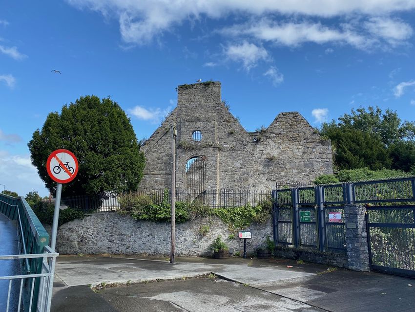
ST CANICE, FINGLAS Conservation & Management Plan

    CONTENTS

    1.0   EXECUTIVE SUMMARY                                        5

    2.0   INTRODUCTION                                             10

    3.0   UNDERSTANDING THE PLACE                                  14

    4.0   PHYSICAL EVIDENCE                                        27

    5.0   STATEMENT OF SIGNIFICANCE                                48

    6.0   DEFINING ISSUES & VULNERABILITY                          55

    7.0   CONSERVATION & MANAGEMENT POLICIES                       61

    8.0   CONSERVATION & ACCESS STRATEGIES                         66

    SELECT BIBLIOGRAPHY

3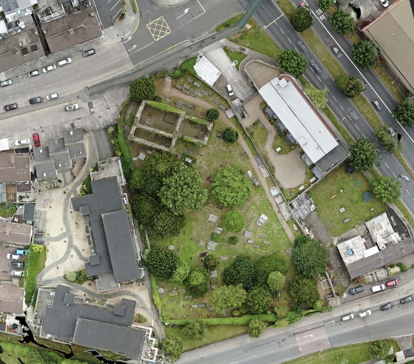
ST CANICE, FINGLAS Conservation & Management Plan

4
ST CANICE, FINGLAS Conservation & Management Plan

1.0 EXECUTIVE SUMMARY

1.1     PREAMBLE
This conservation and management plan for St Canice’s ecclesiastical site
was commissioned by the City Archaeologist of Dublin City Council with
support from Parks, Biodiversity & Landscape Services and the Local Area
Office. Prepared by 7L Architects in collaboration with Eachtra Heritage,
the purpose of the plan is to assess the history, cultural significance, and
current condition of the graveyard – its monuments and boundary wall. It
assesses the threats to its significance; outlines a conservation strategy and
makes recommendations for enhancement, improved management, and
interpretation. This plan is drawn up in the context of proposals to conserve
the church, mortuary memorials, and the long-term conservation of the
medieval high cross. Field surveys were carried out in 2021.

Location                         Church Street, Finglas, Dublin 11
Grid Coordinates                 713097, 738790                                      1: Aerial view of Finglas with site with graveyard outlined in red.
Zoning (adjacent)                Z9 (Z1, Z4, Z15)
Statutory Protection             SMR ref: DU014-066009-; ZAI                         1.2      HISTORIC DEVELOPMENT
                                 RPS ref: 1526
Rating                           National                                                •    During the early medieval period, numerous monastic sites were
Special Interest                 Architectural, Archaeological, Spiritual,                    founded in the immediate hinterland of Dublin Bay to the north and
                                 Historical, Artistic, Social                                 south of the Liffey Estuary.
Principal Dimensions             85 x 45m; 0.34Ha
                                                                                         •    This was a rich cultural landscape that preceded its later
Inspection Dates                 May & August 2021
Prepared by                      Fergal Mc Namara & John Tierney                              development as a city, to which these medieval sites survive in
Report Issued                    April 2022                                                   placenames and a rich archaeological heritage.

                                                                                 5
ST CANICE, FINGLAS Conservation & Management Plan

•   Finglas, derived from Fionn Ghlas or clear water, is associated with          1.3   PHYSICAL EVIDENCE
    Cainnech or St Canice, who by tradition founded a monastery
                                                                                    •   The ecclesiastical site at Finglas consists of a medieval church ruin,
    beside a stream at this place in 560 AD.
                                                                                        much-altered over time, set within a bell-shaped graveyard
•   By tradition, St Patrick is also associated with Finglas, with a well               surrounded by a fine collection of mortuary monuments taking a
    dedicated to his name close to the church site. It is thought that he               variety of forms.
    resided at Finglas and proclaimed it to be the future capital city.
                                                                                    •   Several phases of construction, addition and repair can be seen on
•   In 1649, the army of Oliver Cromwell marching towards Drogheda                      the walls of the church and along the boundary wall. Ivy and shrubs
    is thought to have been responsible for toppling of the                             have colonised the walls to varying degrees; and have rooted into
    Nethercross, or that it was taken down and buried deliberately by                   the wall tops and centre of the wall.
    parishioners to prevent its desecration. Similar accounts relate to
                                                                                    •   Of most concern to these walls is the damage caused by tree roots
    stone crosses at Crumlin and Kilgobbin.
                                                                                        and ivy, some historic, where cracks and bulging can be seen,
•   In his diaries, antiquarian Austin Cooper records a visit to Finglas in             putting the surviving medieval fabric at risk.
    September 1779, where he encountered an old cross in the
                                                                                    •   The graveyard is inaccessible to many with mobility impairments,
    graveyard with its top broken off and lying by its base.
                                                                                        with steps at both gates. Within the graveyard the path is level.
•   In 1816, tradition has it that it the high cross was uncovered at
                                                                                    •   For a relatively small graveyard; among the 363 visible monuments
    Watery Lane using local knowledge and re-erected in the
                                                                                        there are a wide range of types and many that are of fine quality
    graveyard by Rev. Robert Walsh. It is possible that it being broken,
                                                                                        and of particular historical interest - vaults, pedestal monuments,
    buried and re-erected are the reasons for its unusual proportions,
                                                                                        wall memorials, chest tombs, table tombs, ledger slabs, crosses
    different stone to its base, and deep channels cuts into its shaft.
                                                                                        and headstones.
•   In 1953 Dublin cities boundaries were extended, which included
                                                                                    •   While the graveyard is closed to new plots, families retain rights for
    Finglas. It changed from a country village to a Dublin City suburb
                                                                                        burials. The graveyard is a repository of funerary art with examples
    during the 1950’s, the 1960’s, the 1970’s and continued to develop
                                                                                        dating to the seventeenth century.
    well into the 1990’s.

                                                                              6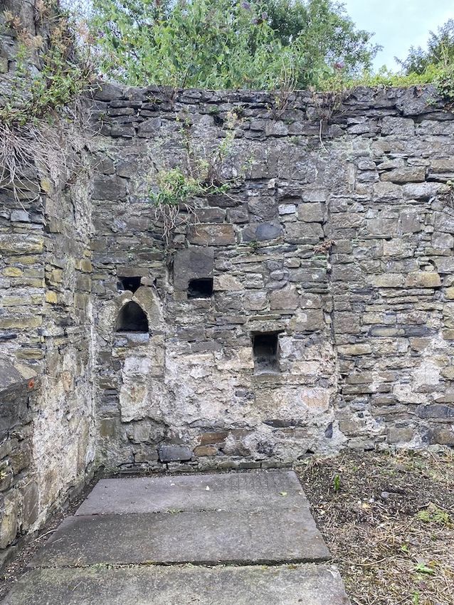
ST CANICE, FINGLAS Conservation & Management Plan

1.4   SIGNIFICANCE                                                                  1.5   THREATS
  •   Its gravestones are fine examples of monumental masonry, with                   •   The surviving church ruin, while relatively stable and intact, is at risk
      hand-lettered inscriptions and vivid iconography memorialising                      from encroaching vegetation as well as the use of hard cement
      long-deceased individuals, several of whom were born in the                         mortars and a lack of maintenance.
      seventeenth century.
                                                                                      •   Encroachment of development and vegetation, especially ivy, has
  •   Its mature planting includes a fine collection of yews, that appear                 caused the loss of parts of the boundary walls to the graveyard,
      to have been planted to line a former path. Its vestry books record                 along with displacement of some of the monuments. Mature trees
      tree planting from the mid-seventeenth century which add to their                   in the graveyard are also displacing nearby monuments, damaging
      interest. It contains a valuable habitat in an urban environment.                   both their stonework and metalwork.
  •   Those who visit the graveyard can enjoy it as a leafy arbour, with a            •   Other defects, inherent in the materials or their assemblies, are the
      pleasant sense of a ‘secret garden’, secluded from the urban                        cause of decay for several the most impressive monuments.
      village, while visiting the graves of ancestors, notable individuals or
                                                                                      •   Being locked and not universally accessible is a barrier. Local
      fine examples of monumental art, within an authentic historic
                                                                                          interest in the site along in the form of committed and informed
      setting.
                                                                                          volunteers should be supported as far as possible. Local guides
  •   As an intact, multi-phased ecclesiastical site of early medieval                    could provide the best means of presenting the site during special
      origins with - a high cross; Viking burial; medieval church and high-               events, on appointment or at weekends.
      status memorials - St Canice’s Finglas is undoubtedly a place of                •   Challenges to accessing the graveyard for people with mobility
      Regional Significance. Further research and works to conserve the                   impairments are not easily addressed. It is important that any
      site may allow it to be considered of National Significance.                        proposals to improve access are carefully considered to avoid
                                                                                          unacceptable impacts on the built heritage.
  •   It is also important to acknowledge the significance of those lesser-
                                                                                      •   The condition of the Nethercross and medieval church are of most
      known people buried at Finglas, whose descendants may seek their
                                                                                          concern. Strategic tree removal and specialist repair works are on-
      memorials out to pay their respects, or search records where burials
                                                                                          going to address the risks to safety and preservation. However,
      are no longer marked. Several community initiatives have been
                                                                                          without intervention, these monuments will continue to decay.
      undertaken that have reinforced these connections.

                                                                                7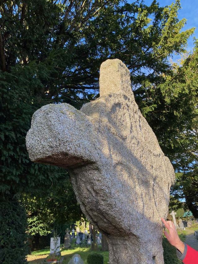
ST CANICE, FINGLAS Conservation & Management Plan

1.6   POLICIES                                                                   •   Care should be taken not to disturb the surviving wall plaster during
                                                                                     repair works, and pilot works to consolidate these layers should be
  •   Repairs to historic fabric should be carried out using conservation            progressed.
      methodologies that conform to the guiding principles set out in the
                                                                                 •   Vegetative growth should continue to be monitored to avoid
      ICOMOS charters, using appropriate details and materials.                      further damage, while new planting could enhance the
  •   As the immediate environs of the ecclesiastical site are further               presentation of the graveyard and improve biodiversity.
      developed, its cultural heritage needs to be protected from                •   Careful tree surgery in the vicinity of the Nethercross is to be
      adverse impacts such as overshadowing or overlooking, poor                     advanced in 2022 that will remove the risk of falling branches and
      design and massing detracting from the setting.                                improve drying out to the shaded west face.
  •   Liaison between the different stakeholders should be fostered to           •   A habitat survey of the graveyard should be commissioned with
      share knowledge and ensure that best practice is adhered to in                 recommendations for their protection and maintenance.
      relation to any proposals for conservation works to the built and
                                                                                 •   Studies should be advanced on the modern history of the church
      natural heritage.
                                                                                     and graveyard including its burial records and vestry books dating
                                                                                     to the seventeenth century.
1.7   RECOMMENDATIONS
                                                                                 •   A structural survey should be undertaken of the Nethercross in
  •   Stabilisation of the boundary walls and removal of damaging trees              2022 to determine what risks to its stability are present due to its
      using best conservation practice should be a priority. This would              present location and its continued deterioration.
      remove a risk to public safety along the footpaths.
                                                                                 •   Further consultation and analysis of the Nethercross - regarding its
  •   Several of the monuments have been disturbed so that they are at               past, present and future - should be advanced. It is essential to
      risk of collapse. Urgent action is required to the monuments close             continue to engage the public on the findings and actions for its
      to the stone porch, among the most visible to visitors.                        conservation.
  •   In 2022, an application should be made for the repair of the chancel       •   Option analysis has identified the relocation of the high cross into
      and boundary walls under the Community Monuments Fund,                         the church where it could be sheltered and a replica placed in its
      Stream 1; these areas are under the most threat.                               current location as being the preferred conservation strategy.
  •   In future years, repairs to the nave, side chapel and entrance porch       •   Such a project will need several years of planning, design,
      should also be advanced.                                                       consultation, approvals and fundraising prior to implementation.

                                                                             8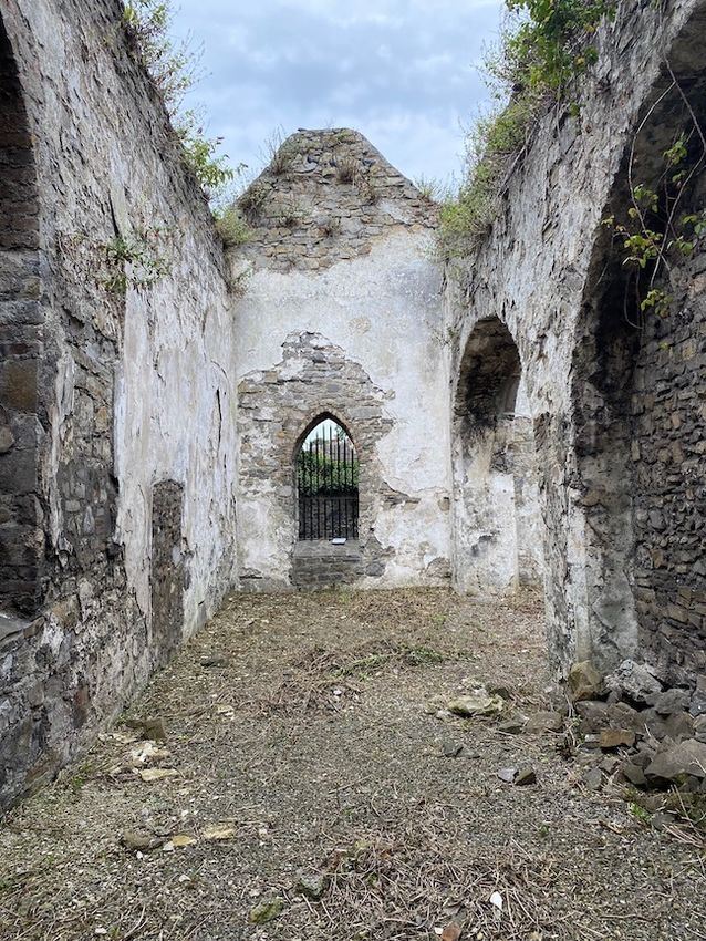
ST CANICE, FINGLAS Conservation & Management Plan

1. Aerial orthoimage of site showing principal features and surviving ruin.

                                                                 9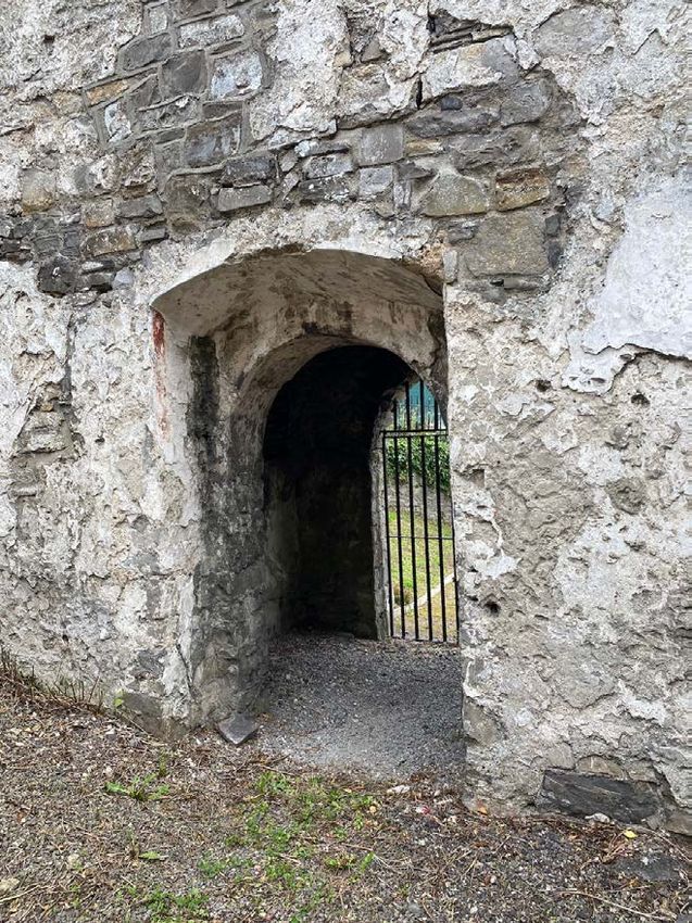
ST CANICE, FINGLAS Conservation & Management Plan

2.0 INTRODUCTION

2.1     BACKGROUND & METHODOLOGY
The ecclesiastical site of St Canice at Finglas occupies a prominent location
in a busy suburban village to the north of Dublin city, approximately five
kilometres northwest of its centre. The name Finglas is derived from the
Gaelic Fionn Ghlas, or clear stream, after the stream that rises six kilometres
to the north near Dunsoghly Castle and flows southwards through the
village to join the River Tolka at Glasnevin.

It forms part of a sixth-century ecclesiastical foundation dedicated to St
Canice; all that survives from this period is the Nethercross, a carved granite
high cross that is probably dates to the early tenth century. Today it consists
of a medieval church ruin, much-altered over time, set within a bell-shaped
graveyard surrounded by a fine collection of mortuary monuments taking a
variety of forms. The discovery of a Viking burial in 2004 just outside the
the graveyard added another layer of significance to the site.

In 1953 Dublin cities boundaries were extended, which included Finglas. It
changed from a country village to a Dublin City suburb during the 1950’s,
the 1960’s, the 1970’s and continued to develop well into the 1990’s. While
it is a well-maintained and secure graveyard, there are issues with
encroachment by trees and vegetation on the church, monuments and
boundary walls. Some gravestones are in a poor state due to natural
weathering over time and would benefit from specialist conservation repair.
                                                                                       2. Sketch plan prepared by Eachtra Heritage as part of their monument survey.

                                                                                  10
ST CANICE, FINGLAS Conservation & Management Plan
This conservation management plan was commissioned by the City
Archaeologist of Dublin City Council to safeguard the built and natural
heritage of the ecclesiastical site. A condition survey was carried out to the
church, Nethercross, mortuary monuments and their setting. In recent
years, there have been representations to Dublin City Council, the
guardians of the graveyard, to undertake works to the church and mortuary
monuments in the graveyard. There is also concern about the Nethercross
within the local community, given its condition and the possibility that it
might need to be relocated.
2.2 AIMS & OBJECTIVES
Essentially, the aim of conservation is to retain the cultural significance of a
place. Published by ICOMOS in 2013, the revised Burra Charter provides a 3. Inventory at https://historicgraves.com/graveyard/st-canices-finglas/du-stcs
model for the conservation and management of places of cultural
Also of relevance is the Quebec Declaration On the Preservation of the
significance; setting out standards and guidelines for its guardians. This
Spirit of Place, adopted by ICOMOS in 2008. In the declaration, spirit of
group might include owners, managers and custodians, consultants,
place is defined as - the tangible (buildings, sites, landscapes, routes,
statutory advisers, opinion-formers, decision makers and contractors.
objects) and the intangible elements (memories, narratives, written
Places of cultural significance enrich people’s lives, often providing a deep documents, rituals, festivals, traditional knowledge, values, textures,
and inspirational sense of connection to – family and the community; the colours, odours, etc.), that is to say the physical and the spiritual elements
landscape; to the past and to lived experiences. A fundamental principle of that give meaning, value, emotion and mystery to place. For Finglas, this
the Burra Charter is that places of cultural significance should be conserved would require seeking to define and conserve the living, social and spiritual
for the benefit of both present and future generations. The charter defines nature of the graveyard.
conservation as - all of the processes of looking after a place so as to retain
As such, the aims of this Conservation Plan are to:
its cultural significance.
11ST CANICE, FINGLAS Conservation & Management Plan
• provide an accurate record of the ecclesiastical site, through field
studies and research;
• understand the significance of its cultural heritage both tangible
and intangible along with its natural heritage;
• identify any threats to this significance;
• formulate policies to address the threats, and to inform and guide
the future preservation and management of the Nethercross, the
church, its graveyard and its associated cultural heritage;
• manage change by proposing a sustainable vision for the future of
the historic place, to act as a guide for future decision-making;
• identify priorities for the conservation of the graveyard where
capital works and ongoing maintenance.
2.3 LIMITATIONS
Areas that were not inspected included those that required special access
at high level, were fenced off or locked, buried, obscured by ivy or
vegetation. Specific limitations are noted within the text.
2.4 ACKNOWLEDGEMENTS
The Steering Group was chaired by City Archaeologist Ruth Johnson, with
advice and feedback provided by Michael Carroll Assistant Area Manager
and his predecessor Aidan Maher; Christina Todd Landscape Architect;
Ludovic Beaumont; Fergus O’Carroll and staff at DCC Parks Operational
team; Niamh Kiernan, Architectural Conservation Officer; Larry Dooley and
Darragh Cunningham all of Dublin City Council.
4. Methodology for conservation management plans from Burra Charter.
12ST CANICE, FINGLAS Conservation & Management Plan
5. Comparative timeline of Finglas in comparison to Irish and European historic events.
13ST CANICE, FINGLAS Conservation & Management Plan
3.0 UNDERSTANDING THE PLACE
3.1 HISTORICAL DEVELOPMENT
The research below was commissioned by DCC under the CMF 2021 fund
from Dr Paul McCotter to understand the medieval and late-medieval
phases of development at the ecclesiastical site up to the seventeenth
century. Some adaptations and additions by the authors have been
included.
Early Ireland appears to have had many churches of varying size. The Irish
prescriptive material, largely of eighth-century date, suggests a multi-
layered hierarchy of churches.1 At the top was the civitas or major church
centre with bishop, abbot, airchinnech (administrator, normally in minor
orders), college of secular married clergy, coenobitic houses of monks and
nuns, hospital, hospice, school, several churches and concentric rings of
sacred precincts marked by cross inscribed stones, sometimes with lay
settlement around its perimeter featuring a market, and extensive landed
estates in several sections, usually with the largest block around the civitas
itself. This is the most visible rank of Irish church. 2 Various mentions of other
ranks of church occur, in particular the andóit, often translated as ‘mother-
church’, which was a superior church with certain rights over inferior
6. Medieval parish churches of North County Dublin (OPW).
1
The principal texts are the ‘Ríagal Phátraic’, the ‘Collectio Canonum Hibernensis’, (Leipsig, 1885); Liam Breatnach (ed), Córus Bésgnai: an old Irish law tract on the
and ‘Córus Bésgnai’, for which see J.G. O’Keeffe, ‘The rule of Patrick’ in Ériu 1 church and society (Dublin, 2017).
(1904), 216–24; Hermann Wasserschleben (ed.), Die irische Kanonensammlung 2
See also Tomás Ó Carragáin, Churches in Early Medieval Ireland (London, 2010),
9-10.
14ST CANICE, FINGLAS Conservation & Management Plan
churches (sometimes called dalta, or ‘disciple church’), such as that of the name occurs in an early genealogy of the Uí Failgi listing one of their
appointment of its cleric in certain circumstances, as well as the right to members, Uí Dimai Lecarda, as occupiers of Finglas.7 These appear to have
some of their income.3 In the seventh century Tírechán speaks of ‘primary been an ecclesiastical family, and at this time – the late sixth century – we
churches’, while the slightly later Hibernensis speaks of aeclessia libera note that the territory of the Uí Failgi (which gives its name to baronies
(‘free churches’) and ‘churches called dominicus’ (churches bearing the located in north western Kildare as well as to the county of Offaly) stretched
onomastic term domnach). 4 Etchingham’s comprehensive treatment of eastwards much nearer to Dublin than it later would.8 This may suggest that
church organization at this period interprets the evidence to indicate a the church of Finglas was of sixth century foundation, probably established
hierarchy of churches, seeing the domnach and primary churches as non- by Saint Cainneach of Aghaboe as is the tradition.
episcopal mother-churches occupying the middle rank of a three-tier
The annals provide us with most of our early references to Finglas, and may
hierarchy, at the top of which is the episcopal civitas. 5 Under these he
be transcribed as follows:
places the local churches. Another example he advances is a structure
suggested by the ninth-century vita of Cartach of Lismore. This refers to • 763.2, death of Faelchú, abbot of Finglas.9
churches representing a middle layer of hierarchy, mother-churches under • 791.1, death of Caínchomrac, bishop of Finglas.
which would have operated something like chapels. Etchingham goes on • 796.1, death of Dubliter, bishop and anchorite, of Finglas.
to demonstrate the usage of the term paruchia to refer to the jurisdictional • 812.2, death of Flann, son of Cellach, abbot of Finglas and a
area of both the top and middle layers of this hierarchy.6 bishop.
• 817.12, death of Feargus of Ráith Luraig, abbot of Finglas.
Finglas is an old name, Finnglaissi as recorded in AD 763 in Old Irish. It • 825.2, death of Cuimnech, abbot of Finglas.
derives from ‘bright or white stream’, that which still flows through Finglas • 838.1, death of Bran, bishop and scribe of Finglas.
to join the Tolka to the south. What is probably the earliest reference to the • 867.2, death of Robertach of Finglas, bishop and scribe.
3
Colmán Etchingham, Church organisation in Ireland AD 650 to 1000 (Maynooth, 6
Etchingham, Church organisation, 122–3, 144, 168–70, 254.
1999), 224–37; Richad Sharpe, ‘Churches and communities in early medieval 7
M.A. O’Brien (ed.), Corpus Genealogiarum Hiberniae (Dublin, 1976), 65.
Ireland’ in John Blair and Richard Sharpe (eds.), Pastoral Care before the parish 8
Paul MacCotter, Medieval Ireland: territorial, political and economic divisions
(Leicester, 1992), 93. (Dublin, 2008), 174.
4
As quoted by Etchingham, Church organisation (115–6). See also Donnchadh Ó 9
All annal references sourced from the Annals of Ulster, Celt edition
Corráin, ‘Ireland c. 800: aspects of society’, 596. (https://celt.ucc.ie//published/T100001A/index.html), accessed August 5, 2021.
5
Etchingham, Church organisation, 116, 121–3, 233–4.
15ST CANICE, FINGLAS Conservation & Management Plan
Our next source is the martyrologies. These are lists of saints, their church Finglas in the martyrologies, as we have seen above. The reference in
and their feastday. Later glosses are included. Óengus to ‘Finglas Cannig’ indicates that the belief that Finglas was
founded by Cainneach is at least as old as the ninth century. According to
Martyrology of Tallaght, circa 830:10 his lives, Cainneach was of the Ciannachta of Glinne Geimin, that is,
• January 21, Flann son of Laich, abbot of Finglas. northern County Derry.13 The cantred just to south of this territory is that of
• January 27, Noe of Finglas.
Rathlowry, also the name of an important church here, now shortened to
• May 15, Dubliter, abbot of Finglas.
Maghera (Machaire Ratha Luraigh). 14 This may explain the presence of
• September 24, Faelchú of Finglas.
Feargus of Ráith Luraig as abbot of Finglas in the early 800s. In addition
• Martyrology of Óengus, circa 830:11
there is an early reference in an list of Irish saints to a Mochua of Finglas,
• January 21, Fland, bishop of Finglas.
• May 15, Dublitir, abbot of Finglas Cannig beside Dublin. who seems to share close genealogical ties with Cainneach.15
• September 24, Faelchú of Finglas. It would be normal for major churches such as that of Finglas to have junior
churches within its estate. Several ecclesiastical toponyms can be found in
Martyrology of Gorman, circa 1170:12
Finglas parish, such as Kildonan, Kilreesk and Kilshane. We do not know
• January 21, Fland, a bishop in Finglas.
who Donnán was while Kilreesk refers to the church being in or near a bog.
• January 27, Noe of Finglas.
• May 15, Dublitir the good and fair, abbot of Cannech Finglas. The etymology of Kilshane is unclear but it is the only site to have
• September 24, Faelchú of Finglas. ecclesiastical remains associated with it.16 Finally we might note the church
of Uachtar Muaíde, associated with a saint Mo Choe. This place can be
identified with Broghan in Finglas parish, although no church site is now
The evidence of the martyrologies tells us something of the early history of
the church of Finglas. Here the main dedication is that to Cainneach
(Canice) of Aghaboe, still remembered in Finglas, and explicitly linked with
10
R. Irvine and H.J. Lawlor (eds.), The Martyrology of Tallaght (HBS 68, 1931). 15
P. Ó Riain (ed.), Corpus Genealogiarum Sanctorum Hiberniae (Dublin, 1985),
11
Whitley Stokes (ed.), The Martyrology of Oengus the Culdee (London, 1905). 707.839.
12
Whitley Stokes (ed.), The Martyrology of Gorman (London, 1895). 16
See SMR no. DU014-01201. In Kilshane stands an 18th century church with a
13
P. Ó Riain, A dictionary of Irish saints (Dublin, 2011), 138-140. I think it unlikely medieval font which is believed to stand on the site of a medieval church, there is
that Cainneach is a double for Colm Cille. an associated graveyard and holy well.
14
MacCotter, Medieval Ireland, 225-6.
16ST CANICE, FINGLAS Conservation & Management Plan
known.17 There were at least two saints of the name, the more prominent peace conference in Tara between the two main competing overlordships
being Mo Choe of Nendrum, Co. Down. He is associated with Saint Patrick of the time, the Uí Néill and the Laigin.
and is given a Dál Riada pedigree, once again showing a possible
Perhaps the earliest surviving material indicator of Finglas’ erstwhile
association between Finglas and Ulster.18
importance is its early stone cross. While now in the churchyard in Finglas
The church of Finglas is also associated with the founder of the Celi Dé, this was not its original position, which is said to have been somewhere on
Máel Ruáin of Tallaght (which he founded in 774). The Celi Dé originated Watery Lane north of the church.21 This is of little value as an indicator of
as a loose ascetic, homiletic and reforming movement rather than any kind location as it runs northwards from Finglas village, and its original siting is
of structured group. The late ninth century Triads connect abbot Dublitir of unknown. Was this perhaps in the small townland of Glebe, lying at the end
Finglas with Máel Ruáin, calling them both ‘the eyes of Ireland’.19 Another of the lane? Some indication of this is found in the story of the cross. This
interesting reference occurs in the Celi Dé text ‘The customs of Tallaght’.20 states that upon Cromwell’s arrival in Dublin the cross was dismantled and
In this a nun approaches abbot Dublitir asking permission to stay in the buried to prevent it from desecration. A local clergyman, Robert Walsh,
nuns quarter (Less Callech) in Finglas. Dublitir was angry at this presumption who was vicar of Finglas in the early 1800s, discovered an old man who told
and refused permission. This exchange was overheard by his confessor this family story as handed down to him. His grandfather, when a boy, had
bishop who intervened and overruled Dublitir and granted the nun been present at the burial of the cross in a corner of one of the ‘Glebe
permission. This passage is interesting in that it indicates that there was a fields’. Dr. Walsh proceeded with some workmen to the spot indicated in
convent of nuns as part of the church establishment of Finglas circa 800 this traditional story. In due time he unearthed the cross from its resting
and, when taken with some of the annal entries above, indicate that Finglas place of 160 years, and had it erected in the southeast corner of the ancient
may have been the seat of a bishopric. It is of interest to note that the only churchyard where it now stands.
two episcopal seats we find at this period in Dublin north of the Liffey are
As pointed out by Maighréad Ní Mhurchadha, several parish church sites in
those of Lusk and Finglas. The status of the church of Finglas is further
Dublin share this story of Cromwell’s forces necessitating the removal or
revealed by the annal of 780.12 (AU) which shows abbot Dublitir chairing a
burying of valuables or revered objects or effigies including stone crosses.
17
C. McNeill (ed.), Calendar of Archbishop Alen’s Register (Dublin, 1950), 24, 173, 19
K. Meyer (ed.), The Triads of Ireland (Todd Lecture Series, Dublin, 1906), 2.
213. 20
C. Harrington, Women in a Celtic church (Oxford, 2002), 108-9.
18
https://www.dib.ie/biography/mochoe-mochaoi-mahee-coelan-a5846, accessed 21
W. Joyce, The neighbourhood of Dublin (Dublin, 1921), 268-9.
August 12, 2021.
17ST CANICE, FINGLAS Conservation & Management Plan
She also notes that Austin Cooper, antiquarian, paid a visit to Finglas in The discovery of a Viking burial in June 2004 by archaeologist Dr John
September 1779, and found an old stone cross, the top of which was Kavanagh just outside the current west wall of the graveyard provides
broken with its top lying under its base. He goes on to describe how Roman evidence of their presence at Finglas and at the monastic site. A shallow
Catholics in the area prayed at the cross during funerals. grave contained the remains of a 25 – 30 year old aristocratic Norwegian
woman buried in full dress. The lower portion of the remains included the
The small (six acre) townland of Glebe lies approximately two kilometres left humerus and lower legs that had been truncated from earlier sewage
north of Finglas church. Today it is urbanized as McKelvey Road and works. Several artefacts were discovered with the remains including a
Avenue and is bounded on the east by St. Margaret’s Road. It will be noted bronze object, antler/ bone comb and a brooch. The brooch made of a
that this is some distance north of the ecclesiastical enclosure at Finglas copper alloy gilded in gold and silver believed to have been from Norway
(see below). Is it possible that the original location of the Finglas cross or Sweden. The brooch was the first to be discovered in Ireland since 1902
marked an entrance to a large outer enclosure? This seems unlikely as it and is in the care of the National Museum of Ireland.
would be much larger that such enclosures typically are.
The evidence of the martyrologies however suggests that the church must
We see that the annals quoted above cover the period 763 to 867. The late have been re-founded at some stage and was certainly in operation again
start date may simply be due to lacunae in the records but the relatively by the mid-twelfth century. In 1170 troops of Anglo-Norman archers were
early end date is suspicious, especially given the virtually continuous quartered in the church, again suggesting that there were significant
annalistic coverage given to neighbouring foundations to the north, such buildings in Finglas at that time. 23 Perhaps this church featured the dressed
as Lusk and Swords. Significantly, Cogadh Gaedhill re Gaill, which contains granite that can be found on the north gable. It is not certain whether the
accurate annalistic material, mentions the plunder of ‘Finnghlas Cainnigh’ older church and sanctum of the ecclesiastical site was located precisely
by the Vikings circa 851.22 One must suspect that the proximity of Finglas where the church and graveyard site are found today. Another possibility
to Viking Duiblinn had some negative effect on its existence, at least in the would be the grounds of the nineteenth century church across the street.
earlier Viking period.
The church of Finglas seems to have been one which occupied the top layer
of church organization, a civitas church with resident bishops. Accordingly
its population would have been diverse featuring senior clergy, including
22
J.H. Todd (ed.), Cogadh Gaedhill re Gaill (London, 1867), lxi, 2, 19. 23
F. Elrington Ball, A History of the County of Dublin, ect., volume six, (Dublin,
1920), 84; A.B. Scott and F.X. Martin (eds.), Expugnatio Hibernica by Giraldus
Cambrensis (Dublin, 1978), 96.
18ST CANICE, FINGLAS Conservation & Management Plan
bishops, abbots, airchinnigh (lay administrators in minor orders), educators, The arrival of the Anglo-Normans changed everything. Finglas was erected
scholars, anchorites and others. While some of these were celibate most into an Anglo-Norman manor and became in most things just another
were not. There would have been sub-groups of celibate priests, nuns, manor tenure typical of the period. The income from the manor largely
monks and anchorites (hermits). A large proportion of the clerical went to the archbishop of Dublin while the tithes went to the prebend of
population would have consisted of manaig (manach = monk), a term which the chancellor.26 The native population, or at least the upper echelons were
covered several layers of tenants and farmers on the extensive church lands. removed or relegated to cottier and betagh tenure, essentially small
Aside from the celibates most of the clerical population occupied holders holding at will, sometimes by labour service rather than a cash rent
hereditary roles. Unfortunately, we know little of this thriving native Irish or by a mixture of both.27 Unfortunately the names of such tenants are not
population of Finglas. We know something of the pre-Norman recorded but we do have the names of the higher tenants, the freeholders,
ecclesiastical structure of Fingal, and it seems clear that in this structure none of which are native Irish. 28 We do have one reference to betaghs
Finglas ruled (received a rent and appointed clergy) over several inferior farming the townlands of Ballygall, Kildonan and Kilshane, and these may
churches. We know this to be the case with the church of Artane, but it must well be natives. There is a reference from Finglas in the mid-fourteenth
have pertained to several others as well around the Tolka valley. There is century of a court case where ‘farmers’ (usually tenants by leasehold) in the
some evidence to suggest that the parishes of Ward and St. Margaret’s may manor, all of whom bore Irish surnames, complained of having to pay a
also have been subservient to Finglas.24 Finglas thus ranked in status with much higher rent for their lands than the burgesses did. All of these had
other senior local churches such as Lusk, Swords and Clonmethan. Like Irish names.29
them Finglas was surrounded by a curved ecclesiastical enclosure of early
The manor was administered by a paid official, the seneschal or serjeant,
date.25
who presided over the manor court in the absence of the archbishop,
dealing with tenurial and civil cases. This court operated from a dedicated
24
Ball, History of the County of Dublin, 116; Alen’s Register, 33. Analysis of Sites in Ireland, Wales and France. Technological University Dublin.
25
This ran from a southern point south of the graveyard along the east side of the doi:10.21427/D7N304.
Green, then along ‘King William’s Rampart’ to a high point north of Ashgrove 26
Alen’s Register, 42 and passim.
House, back down to Ballygall Lane, then following the curved road pattern passing 27
Alen’s Register, 173, 212-13.
the Catholic church and then Barrack Street and so back to the beginning. Swan 28
Alen’s Register, 173-4, 212-13.
believed that the western segment contained a market. See Crowley, Clare (2009), 29
Ball, History of the County of Dublin, 86.
The Origin of the Curvilinear Plan-Form in Irish Ecclesiastical Sites: A Comparative
19ST CANICE, FINGLAS Conservation & Management Plan
manor court building, recorded in 1656 as the Old Court, lying somewhere and rabbits, were preserved.34 The deer park was still known, at least as a
in Finglas village.30 There is a reference from the 1260s to the court as lying denomination, in the 1590s.
‘at the cross of Finglas’ and so along or near Church Street. This reference
Given its proximity to Dublin the episcopal residence and Court at Finglas
probably refers to a crossroads but possibly to a stone market cross.31 The
were popular with the archbishops. Archbishop Fulk died while a resident
archbishop would reside in this building when his iterations brought him to
in Finglas, in 1271, as did a later archbishop, Walter Fitzsimons, in 1511.35
Finglas. The site is perhaps to be identified by the later building known as
During the remainder of the sixteenth century the Court was leased out to
‘The Court’ in the church grounds of Finglas. There also appears to have
various laymen, and in 1547 was the residence of the rector of Finglas. By
been an incorporated borough at Finglas, with a burgagery whose extent
1656 the Court was described as ‘a house built of stone, having attached
is not known, but which would certainly have been smaller than the manor.
to it a malt-house, kiln, and five tenements, as well as a garden, an orchard,
This would have been inhabited by a fixed number of burgesses paying an
and thirty acres of land’, when leased by the archbishop to a layman.36 The
annual rent and with certain ‘liberties’, such as the right to be judged by
old church of Finglas was rebuilt in 1657 but was abandoned in favour of a
their peers and not the overlord. There were nineteen burgesses at Finglas
new church in 1843.37 This phase of rebuilding may have included a new
in Archbishop Luke’s time (1230 to 1255).32 There are also records of a park,
entrance porch and alterations to the ogee windows that may have been
by which we might envisage a walled hunting garden, but its location is
installed in the fifteenth century, along with a side chapel with an arcade to
unclear.33 There is an interesting reference to the Court in 1349, upon the
the main nave.
death of archbishop Alexander de Bicknor. In that year mention is made of
the stone walls of the court having been broken by evil doers, and that Turning to the question of the extent of the archiepiscopal manor of
leaden gutters, iron bars from windows, and clamps and bolts from its doors Finglas, the land possessions of the pre-invasion Irish Church descended
had been stolen. It goes on to reference that the kitchen and brew house largely intact to the church of the Anglo-Norman period. This inheritance
contained furnaces and vessels of brass and lead, and mentions a deer park was recognized in the shape of the lands of the various counties of the
and a rabbit warren, in which pheasants and partridges, as well as hares Cross, and these lands enjoyed their own administration. In most cases it
also appears that parochial boundaries inherited such borders and that the
30
R. Simington (ed.), The Civil Survey volume vii, County of Dublin (IMC, Dublin, 34
Ball, History of the County of Dublin, 84-85.
1945), 140. 35
Ball, History of the County of Dublin, 85-87.
31
Alen’s Register, 143. 36
Ball, History of the County of Dublin, 91.
32
Alen’s Register, 85. 37
Ball, History of the County of Dublin, 119.
33
Alen’s Register, 173.
20ST CANICE, FINGLAS Conservation & Management Plan
area of the parish reflected that of the earlier church estates. Finglas was
no exception to such a rule. We possess detailed records of the lands of
the parish from a rental of 1326, which is supplemented by other
contemporary records.38 A thorough evaluation of these lands, including
those with obsolete placenames, confirms that the area of the parish of
Finglas as recorded by the Ordnance Survey of the 1830s and 1840s is
almost the same as the area of the parish as recorded in the thirteenth and
fourteenth centuries. This is true even where lands were lost to the church
of Finglas during the late medieval period. In this context we know that
Jamestown and Cruiserath had been lost to the church sometime before
1529 but remained part of the parish.39 By 1641 we find the tithes of the
parish going mostly to its parson (rector) and a chief or head rent being
paid from most townlands to Trinity College, this having earlier been paid
to the archbishopric. At this time the archdiocese retained in its own
possession a demesne located approximately in or partly in the modern
townlands of Finglas West, Finglas East, Kilshane, Kildonan, Kerdiffscastle
and Tolka. Some of these lands were still owned by the archbishopric in the
1830s.40
* * * * * * * *
Parish churches of the medieval period are their own distinct category of
ecclesiastical building; however, they do share many of the characteristics
of churches built by mendicant orders. While the Anglo Normans had a
large influence in the formation of dioceses and parishes, these structures
7. View of Finglas church in 1698 by Frederick Place. Note bell cote and location
of entrance gate. No window shown on north gables.
38
The rental of 1326 can be found in Alen’s Register, 173-75, but there are 39
Ball, History of the County of Dublin, 87.
numerous other references to the lands of Finglas in this volume. 40
Ball, History of the County of Dublin, 88.
21ST CANICE, FINGLAS Conservation & Management Plan
were already emerging in the early twelfth century. There are examples of Given the ancient origins of the site, the curved boundary alignment along
earlier churches built to serve parishes which were not associated with Church Street is possibly over one thousand years old, although the
monasticism rather the new secular clergy which began to emerge prior to existing stone wall has yet to be dated and is more likely to have been built
the arrival of the Anglo Normans. Many of these churches were built on more recently on ancient foundations. Most Irish graveyards were enclosed
existing monastic sites, replacing earlier timber structures or simpler stone with stone walls during the nineteenth century. References to the
buildings. By the thirteenth century, mendicant orders sometimes construction or upkeep of the boundary wall might be identified in the
vestry books boundary wall at Finglas and may provide some insight into
absorbed existing parish churches into their religious houses. They were
its antiquity or otherwise.
also absorbed to serve new diocesan structures, sometimes being updated,
or refurbished by the Anglo Normans. The construction of a new Church of St Canice across Church Street
designed in a simple Gothic style by Frederick Darley in 1841, led to the
abandonment of the church while burials continued in the churchyard. Wall
memorials in the interior were taken into the new church, which also
featured a bellcote. Slowly, the medieval church lost its roof and windows,
stone may have been taken from the site as it deteriorated.
Today, the graveyard measures 85m x 45 m on a NW-SE axis, and is
enclosed by substantial, high walls on all sides. Some of the eastern wall
collapsed during the construction of the adjacent Fuelyard Apartments in
the 2000s, exposing burials. A boundary retaining wall has been reinstated.
Over the course of the last three hundred years, there have been some
notable individuals interred in the graveyard who were prominent in civic
and cultural life. The interior of the graveyard has a fine collection of
eighteen- and nineteenth-century headstones, apparently in their primary
locations. However, at least two elaborate wall memorials were relocated
to the newer church after 1843. There are approximately three hundred and
sixty monuments comprising simple grave markers; headstones; recumbent
slabs; table tombs; box tombs; pedestals; an obelisk as well as a mural
8. Extract from Roque’s map of County Dublin 1750.
22ST CANICE, FINGLAS Conservation & Management Plan
tablet recorded. Crosses and ringed crosses/Celtic crosses are also to be
found with an interesting example of an early Celtic Revival high cross from
1825 for John Lanigan a noted ecclesiastical historian; simple upright
headstone slab predominate - some with simple sinuous tops; others with
bedstead-type ‘shoulders’. There is a mixture of iconography in the
graveyard reflecting the dual denominations buried here.
Earlier phases of restoration works were carried out by Dublin Corporation
since they took possession of the church and graveyard in the 1950s. While
the use of hard cement and cutting down of corroded railings would not
be conservation practice today, there is little doubt that these initiatives
10. View of present Church of St Canice, Finglas.
helped to preserve many of the monuments, and perhaps the church also.
The graveyard is notable for its well-maintained grounds, and lack of
obvious anti-social behavior that secluded, urban graveyards sometimes
attract. This is in large part due to the arrangement with the Lynch family
over several generations.
9. Watercolour of church in 1878 By JE Carson showing roof timbers surviving,
render shedding and windows missing.
23ST CANICE, FINGLAS Conservation & Management Plan
11. Sketch of Barrack Lane by GV Du Noyer in 1841 showing east gable in the background.
24CH
NORTH GATE
URC
HS
TRE
ET PED
EST
RIA
NO
VER
SS PA
R1
35
Gate PP
(TO
54.42
M
54.28 5
53.70
1
3)
8
2 4
53.68
54.10
54.68
3 7
10
9
54.00
6 11
54.85
54.87
12
PP 15 53.76
53.65
PORCH
65 .52
17
FU
APEX 65 .49
16 13
APEX
EL
54.31
YA
14
RD
53.54
65 .61
53.50
APEX
AP
62 .43
APEX
358
AR
357
NAVE
146
TM
62 .38
APEX 54.05
EN
T
53.47
S
360
361
CHANCEL
SID
EC 362 145
363
HAP
EL 144
Fo
ot
63 .66 54.92
53.92 53.66
55.18 54.19
APEX
pa
54.78
th
103 147 182
54.62
54.60
18 151
55.10 143 148
53.72
54.90
54.02
56 104 149
102
54.12 53.44 181 53.41
Gate
107 53.84 180
54.85
19 Wall
54.97 109
Gate 53.53 179
54.90
20 57 105 142 183
54.08
106
58 154 152
64 54.88
21 55.01
55 63 101 178
22 65 54.03
153 53.77
113 184
54.28 141
12. Layout of graveyard from topographic survey showing monument numbers.
54 100 155 185
54.66
109 114 176
53 54.14
54.80 110 140
54.56
23 99 111
99 98 139 174 175
59 112 138 187 53.32
24 173 186
54.53 193
137 188
54.02
25 54.88 60 54.43
190
53.77 172 190 189 244
26 53.29
53.92
52
194 53.50
25
171 191 195 243
27 135 192
97 170 245 PP
62 197 242
28
54.07
201
54.32
156 169
134
157 199 272
54.83 68 96 203 200
69 202 246
204 274 273
70
51
53.38
168 247 275
207
116 205 302 303
53.07
95 206 276 301
53.90
204
277
208 248
211 53.43 300
50 94 167 210 305
213 212 249 326
72 117
118 270 324
49 73 93 299
53.48 133
Wall 132 240
48 214
119 309
92 215 327
327
166 239 279
ST CANICE'S SQUARE
75 216 307
91 269 329
47 308
30 76 53.47 298
90 238 53.16
53.18
217 268 330 332
331 53.14
332
46
251 250 309 323 53.05
84 218 322
32 88 237 252 333 334
45 53.19
53.30
53.31
77 236 335 53.07
33 78
254 53.41
0
219 337 344
336 343
255 256 53.21
1M
321 345
BA
220
53.32
RRA
79 234 257
87 53.20
CK
34 44 161 280
160 53.62
LAN
35 221 53.47 53.11
E
130 281 295 346 351
222 338
43
5M
294
258 347 53.47
36 320 335
80 282 293 354
54.36
122 223 311
53.49
283
37 353 352
53.60 267 292 319 53.44
259 284
85
42 266 53.66
348 EP
RAM
38
53.11
P
123 54.05
260 318
53.43
233 291
339 53.46 349
10M
54.53 41 53.47
159 261 265 290 317
53.66
53.65
312 340 Gate
STE
285 53.74
53.74
289
PS
40 124 341
53.85 160 350
54.18 125 129 262 53.50
84 232 263 315 342
314
126 224 316
228 53.80 231 264
53.97
54.22
stump
53.80
83 127 227 230 287 288
81 128 229
225
226
82
Wall
SOUTH GATE
NETHERCROSS
WEL
OUN LM
T RO
AD
ST CANICE, FINGLAS Conservation & Management PlanST CANICE, FINGLAS Conservation & Management Plan
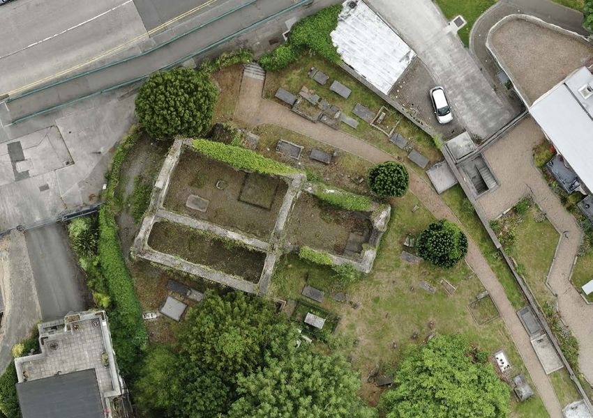
13. Aerial orthoimage of church and immediate environs undertaken by Dr Paul Naessens of Western Aerial Surveys.
26ST CANICE, FINGLAS Conservation & Management Plan
4.0 PHYSICAL EVIDENCE
The descriptions below are based on inspections carried out in August &
September 2021. The following survey concentrates on the condition of the
fabric of the church, high cross, monuments, and boundary wall. The
purpose of the survey is to identify defects and recommend outline repairs
to improve the condition and presentation of the structures.
4.1 SETTING
The graveyard is located along Church Street and was at the centre of
Finglas village until the road was upgraded in the 1990s to link into the M3
motorway. It has always been one of the principal radial routes from the
city centre, heading northwards.
4.2 BOUNDARY WALL
The boundary walls to the graveyard form a bell-shaped enclosure of
14. View of entrance gate from underneath bridge showing extent of ivy.
approximately 0.34Ha, with a NW-SE axis, with a distinct curve along the
Ivy has colonised the wall to varying degrees; in some areas, the ivy is
Church Street to the north and following long-established plot boundaries
confined to the surface, and poses little threat to the condition of the wall.
on the other sides. In total, the wall is almost 250m in length. It is primarily
In other areas, the ivy is more extensive, and has likely rooted into the wall
constructed of limestone Calp, a common building material on historic
tops and centre of the wall, while adding additional weight and ‘windage’
buildings in Dublin. At the southern end, the wall sits on a terrace that is
to the wall making it more prone to collapse. It is heaviest on the north and
held by a concrete block retaining wall along Wellmount Road. On the
south walls to the extent that it poses risk of falling stone along the footpath
north end it varies up to approximately 2m high. To the interior, the wall
on Church Street. While it is patchy along the west wall and a long stretch
height varies between 1-2 metres. Several phases of construction, addition
of the eastern wall is completely clear, this is due to rebuilding in recent
and repair can be clearly seen to sections of the wall.
decades. Along the east side, the collapse was caused by construction on
27ST CANICE, FINGLAS Conservation & Management Plan
been erected to prevent unauthorised access. Of most concern around the
wall is the damage caused by tree roots, some historic, where large cracks
and bulging can be seen. Wherever possible, trees with branches or roots
that bear onto the walls should be removed or pollarded as appropriate.
The buried and embedded roots take time to die off and shrink.
4.3 ENTRANCE GATES
The Barrack Lane entrance gate is wrought iron dating from the nineteenth
century, surmounted by a small iron ringed cross. It has retained its lockcase
and would benefit from adjustment and redecoration. The gate at Church
Street is a replica of that gate in mild steel. It is part of an initiative in recent
years to reopen this historic entrance, improving permeability and
accessibility.
4.4 PATHS & LANDSCAPING
St Canice’s graveyard is well-maintained and secure, with mature trees,
15. View along curved boundary wall to interior showing railings to wall top.
making it a pleasant place to visit at a remove from the busy roads and
the adjacent Fuel Yard site which caused the exposure of human burials suburban streets. Both entrances involve steps up onto the level of the
and its reconstruction. Historic sections of this wall have been buttressed, graveyard, which is otherwise quite flat. External levels are about 1m at the
and the internal faces rendered with cement and given a concrete capping. north gate onto Church Street and 2.5m over at Wellmount Road/ Barrack
There is extensive repointing in hard cement which can cause the softer Street. There is less than a metre in level change across the site, generally
limestone to erode sacrificially. Most of the walls have a heavy concrete higher towards the west boundary wall.
capping which is breaking down in places, however much of the north,
south and west flanks are completely covered in ivy so it was not possible
to make a full assessment. Along Church Street, a mild steel palisade has
28ST CANICE, FINGLAS Conservation & Management Plan
19. View of Fuel Yard Apartments and rebuilt wall section.
16. View along curved boundary wall from entrance gate off Church Street.
17. View along west boundary wall showing 18. Large cracks and bulging to boundary 20. View from outside of east wall showing new buttresses.
proximity of yew tree. wall along footpath.
29ST CANICE, FINGLAS Conservation & Management Plan
surface is suitable for wheelchairs, although the graveyard itself is
inaccessible due to the steps at both entrance gates.
The current path layout has been in existence for at least one hundred
years, and the distribution of trees and mortuary monuments suggest that
there was another path leading towards the side chapel of the church from
the Barrack Lane gate, parallel to the south and west boundary walls. The
current path surface consists of resin bound gravel which needs repair or
replacement.
The western and southern ends are well-shaded by mature trees of mixed
species, the central area and east side is relatively clear and sunny. There
is a predominance of yew trees, both native Irish yews and the more
decorative, column-like fastigiata variety. The trees filter out traffic noise
from the busy road and provide for a range of ambiences of light and shade
while marking the seasons.
21. Analysis by L. Beaumont on tree survey showing possible dates of trees.
Five concrete steps are set behind the entrance gates so that the graveyard
is not accessible to those with mobility impairments. Within the graveyard
the paths are generally gently sloping other than a steeper section leading
from the eastern wall to the centre. Access around the graveyard is along a
circuitous pea gravel path that varies between 1m and 3m in width. This
30ST CANICE, FINGLAS Conservation & Management Plan
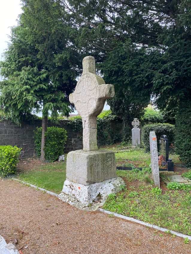
rhomboid base (3) - sitting on a plinth of a mixture of rubble and cement
coated with limewash. It is not believed to be in its primary location -
accounts of it being retrieved from outside the graveyard in 1816 appear
to contradict another reference to a stone cross in the graveyard in 1779.
It is made from Leinster granite and is likely to be a composite cross with
the base being finer grained and greyer in colour to the coarse-grained
shaft and head. It is also likely to have lost parts of its shaft, like the re-
erected granite high cross at Moone, Co Kildare. Today with a relatively
stunted appearance and proportion and may once have stood more than
4m in height. Sitting on the rubble plinth, it has a tilt angle of approximately
2 degrees towards the footpath (east) side. The narrow neck does not look
sufficient to support the large, monolithic head; like most other granite
crosses it has a closed rather than an open ring. We do not know how it is
jointed; other stone crosses have tenon joints.
22. West side of high cross looking east towards Finglas village centre. The coarse mineral grains of the shaft and head are easily displaced by
brushing fingers across any of the stone faces. Rainwater and frost are the
constant source of the stone grains that continue to be found at the base.
4.5 NETHERCROSS
Weathering and oxidation lead to chemical reactions among the mineral
We are grateful to John Meneely of Queens University for the recording of components of the stone that convert feldspar and mica into clays, thereby
the high cross and insights into the geology and stone condition. We also
destabilizing the surface leading to degradation.
refer to the condition report prepared by Carrig Conservation in association
with the late Professor George Sevastopolu. In the longer term the remaining surface detail of the high cross will be lost,
the stone will lose dimension and become unstable leading to cracking and
The Nethercross at Finglas stands just over 3m tall and is the sole surviving collapse. As the cross is top heavy, this might occur sooner than might be
high cross in Dublin. It consists of three components in a simple assembly anticipated, its tilt angle and irregular bedding contributing to this
of - head and neck (1) connected to a short shaft (2) and sitting on a large uncertainty.
31ST CANICE, FINGLAS Conservation & Management Plan
Fig.s 23-25: Sketch of cross by GV Du Noyer (1840) and historic photographs of the west and east side of the cross (ca.1900). Note sunlight on west face, and flash needed for east,
which is the opposite of today, and down to maturing and lost trees.
32ST CANICE, FINGLAS Conservation & Management Plan
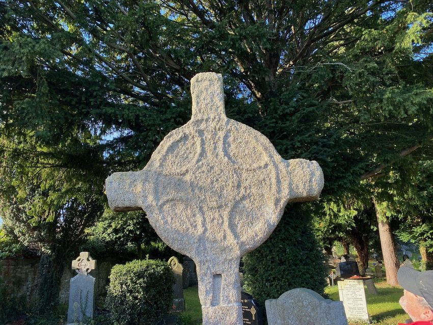
Aside from the weathering, damage to the stone can be perceived on its
surface due to impacts, most likely fallen branches, but also from its
(possible) burial and re-erection. Another possibility would be a deliberate
chipping away at the stone as relics or votive objects. When first
constructed, the cross would likely have had a crisper, more detailed
appearance as found at Moone. Significant losses can be seen on the
exposed terminals of the cross, and along the edges. The profile of the
shaft is no longer straight where it has been gradually whittled away. Its
joints are filled with lead, a traditional method; however, some cement was
used to the junction of the base and shaft, which caused damage when it
became detached. 26 & 27. Extracts from 19.c. OS maps. Note pictogram of stone cross.
It has been recorded in close its present condition and appearance since Photographs held in the National Library dating from ca.1900 show how it
the early nineteenth century. In 1840 Georges Victor Du Noyer, a noted had largely retained its appearance, having possibly lost detail over the 80-
antiquarian and artist, depicted detail and carving not readily discernible 90 years since its re-erection. The photographs demonstrate how the cross
today but may be the result of careful observation and interpretation. is more shaded now given the maturity of the yew tree. Being slower to dry
Carved knotwork motifs can be seen, along with rope edges, with the top out has allowed a green biofilm to colonize the rear (west) face of the cross.
and underside of the ring being much more decorative. There are It is unlikely that this creates additional impacts, other than the increased
conflicting accounts from nineteenth century sources regarding the precise likelihood of a fallen branch. The condition of the Nethercross has been the
location of the Nethercross in the graveyard. Walsh writing in 1888 has it in cause of ongoing concern, and several initiatives have been undertaken by
its present location, while only ten years later Berry in a paper to the Royal the City Archaeologist to come to an understanding about the threats to
Society of Antiquaries mentions it as being in the northeast. Historic map its preservation. Laser scans were undertaken in 2011 and 2017, and work
evidence would appear to confirm the current southeast location. in ongoing to compare these with a laser scan produced for this report. This
Interestingly, the high cross is shown as a pictogram on the first edition OS may provide insights into the rate of decay, but there is little doubt that this
map of 1840. process is active, variable, unavoidable and will be accelerated by climate
change.
33You can also read