Flinders Karawatha Corridor Management Strategy 2014-2019 - A five year plan
←
→
Page content transcription
If your browser does not render page correctly, please read the page content below
Flinders Karawatha Corridor
Management Strategy 2014–2019
                     A five year plan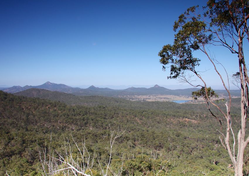
Disclaimer
                    This document has been prepared with all due
                    diligence and care, based on the best available
                    information at the time of publication. The Queensland
                    Government holds no responsibility for any errors or
                    omissions within this document. Any decisions made
                    by other parties based on this document are solely the
                    responsibility of those parties.
                    If you need to access this document in a language
                    other than English, please call the Translating and
                    Interpreting Service (TIS National) on 131 450 and ask
                    them to telephone Library Services on +61 7 3170 5470.
                    This publication can be made available in an
                    alternative format (e.g. large print or audiotape) on
                    request for people with vision impairment; phone
                    +61 7 3170 5470 or email library@ehp.qld.gov.au
                    For more information about this strategy please email
                    Esres.Southernescbranch@ehp.qld.gov.au.
                    Prepared February 2014
                    #30390

Official Partners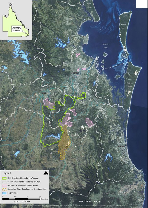
Contents
Foreword................................................................................................................................ 3

Acknowledgements................................................................................................................ 4

Executive Summary................................................................................................................ 5
    Vision................................................................................................................................ 5
    From issues and opportunities to action............................................................................. 5
    How to use this strategy..................................................................................................... 5

Governance............................................................................................................................ 6

Corridor management............................................................................................................. 8
    Biodiversity........................................................................................................................ 8
    Waterways and wetlands................................................................................................... 10
    Rural land use.................................................................................................................... 11
    Cultural Heritage................................................................................................................ 12
    Recreation and scenic amenity........................................................................................... 13

Managing infrastructure assets .............................................................................................. 14

Reporting, research and monitoring........................................................................................ 15

Acronyms............................................................................................................................... 16

Appendix 1............................................................................................................................. 17

Photograph index................................................................................................................... 18

                                                                                                                                               1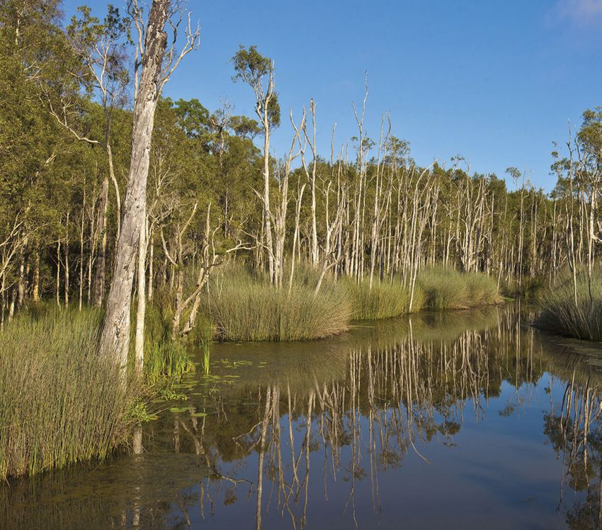
2
Foreword
Balancing population growth and continued economic development with the need to preserve
our diverse natural areas is essential for our state’s prosperity.
The Flinders Karawatha Corridor is an area of remarkable natural beauty and Aboriginal and
European cultural heritage
Extending 60km from the Karawatha Forest on the outskirts of Brisbane, south to the Wyaralong
Dam in the Scenic Rim, the corridor encompasses more than 56,350 hectares and is the largest
remaining continuous stretch of open eucalypt bushland south of the Brisbane River.
Like many parts of South East Queensland, the area has also experienced increased population
growth and development. Land uses include rural landholdings (including grazing and
horticulture), rural residential, residential, sport and recreation providers, Wyaralong Dam,
conservation parks and the Greenbank Military Training Area.
I am pleased to release the Flinders Karawatha Corridor Management Strategy which has been
developed through the collaborative efforts of state and local government departments, non-
government organisations and Traditional Owners.
Importantly, the Strategy is not a statutory planning program. It is a voluntary framework to
guide future activity and balance economic development with environmental and lifestyle
factors for visitors and residents.
It has been prepared to coordinate the efforts of people working, living and visiting the area
and addresses key pressures, including rapid urban population growth, increasing demand for
infrastructure, housing, and recreational services.
The Strategy also establishes arrangements to coordinate existing efforts of government,
community and industry. For example, it includes practical actions such as weed, pest and
fire management plans to ensure we protect the environmental, cultural, social and economic
values of the area.
I commend the strategy to all residents and visitors to Flinders Karawatha Corridor and
encourage interest groups to align their investment and efforts towards its implementation.

    The Honourable Andrew Powell MP
    Minister for Environment and Heritage Protection

                                                                                                 3
Acknowledgements
    The Traditional Owners are acknowledged for their previous and ongoing connection to country
    referred to as the Flinders Karawatha Corridor.
    The generous contributions of the staff from the following organisations have made the
    preparation of this strategy possible:
    •   Queensland Department of Environment and Heritage Protection
    •   Commonwealth Department of Defence
    •   Jagera Daran Pty Ltd
    •   Queensland Department of Transport and Main Roads
    •   Queensland Department of Agriculture, Fisheries and Forestry
    •   Queensland Department of State Development, Infrastructure and Planning
    •   Scenic Rim Regional Council
    •   Ipswich City Council
    •   Brisbane City Council
    •   Logan City Council
    •   Energex
    •   Seqwater
    •   Powerlink
    •   Queensland Outdoor Recreation Foundation
    •   Council of Mayors (SEQ).

4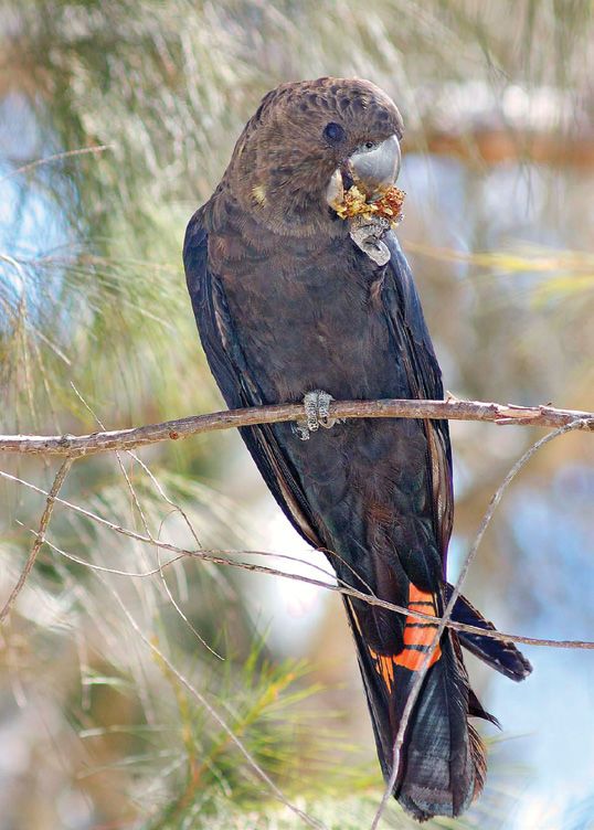
Executive Summary                                                                                    Vision
                                                                                                         ‘That the diverse landscapes of the Flinders Karawatha Corridor are identified
The Flinders Karawatha Corridor is the largest remaining continuous stretch of open eucalypt             and managed to support the sustainability of its significant environmental,
forest in South East Queensland (SEQ). The corridor extends from the 1200 hectare Karawatha
                                                                                                         scenic, cultural, recreational, economic and tourism values and the liveability and
Forest on the southern edge of Brisbane City, along Oxley Creek, through the Greenbank
                                                                                                         wellbeing of existing and future regional communities and landowners.’
Military Training Area and south along the Teviot Range to Flinders Peak, Mt Joyce and
Wyaralong Dam, north-east of Boonah.
Covering an area of over 56,350 hectares, it is recognised as one of SEQ’s most important            From issues and opportunities to action
regional biodiversity corridors, providing habitat and movement opportunities for a range of
species that have state, regional and local significance. In addition, it supports scenic amenity,   The strategy builds on the positive achievements of the past to focus on the following four
outdoor recreation and landscape heritage values of regional significance.                           thematic topics:
                                                                                                     •   Governance
Significant heritage values relating to Aboriginal and European cultural heritage places are
present. These places are protected under a range of planning, legislative and management            •   Corridor management
frameworks at local, state and federal levels, partly due to the size of the corridor and the        •   Managing infrastructure assets
influence and interests of the different stakeholders.                                               •   Research and monitoring
Land uses include rural landholdings (including grazing and horticulture), rural residential,        Each topic is underpinned by objectives and actions.
residential, sport and recreation providers, Wyaralong Dam, conservation parks and the
Greenbank Military Training Area.                                                                    The objectives provide a framework from which the success of the strategy will be
                                                                                                     ultimately evaluated.
The purpose of the Flinders Karawatha Corridor Management Strategy is to articulate a range
of practical, coordinated and measurable management actions which combine to achieve
the shared vision for the area described by the administrative boundary registered as the            How to use this strategy
Karawatha-Greenbank-Flinders Peak Corridor under Section 57 of the Survey and Mapping
Infrastructure Act 2011.                                                                             This strategy includes a range of actions to ensure the long term protection of these social,
                                                                                                     cultural and environmental values and should be used in conjunction with the Flinders
                                                                                                     Karawatha Corridor Environmental Values and Land Use Report (EVaLU) maps.
                                                                                                     The EVaLU maps contain benchmark data which have been generated using the best available
                                                                                                     data to provide a spatial representation on the extent, and in some cases the condition, of
                                                                                                     values at the time the data was collected. This allows the calculation of a benchmark (e.g.
                                                                                                     number of hectares of remnant vegetation) for the purposes of measuring change over time.
                                                                                                     Appendix 1 shows the location of the Flinders Karawatha Corridor within South East Queensland.

                                                                                                                                                                                                     5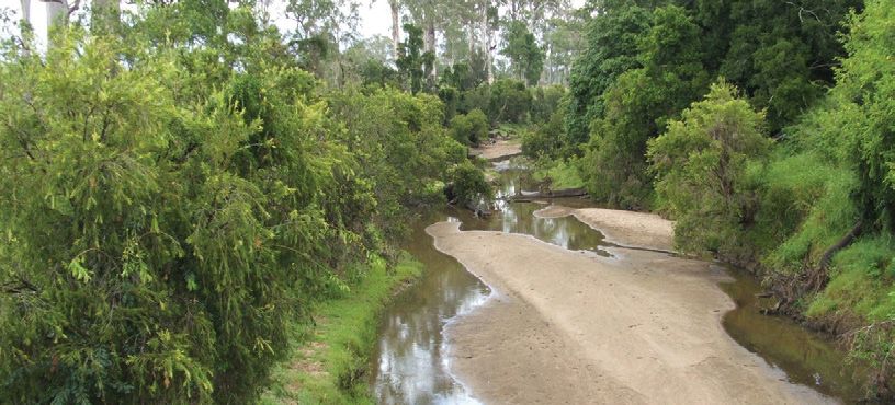
Governance
       Objective: To encourage coordinated community and government action to
       implement strategy actions.
    Context
    The successful delivery of the strategy depends on maintaining and building support and
    ownership among all project partners. Engaging project partners provides an exchange of
    knowledge and information that improves outcomes.
    To coordinate the efforts of people working in environment and natural resource management,
    and to guide sustainable development, the Flinders Karawatha Regional Panel will work to
    implement the strategy actions through to 2019.
    The Flinders Karawatha Regional Panel reports to the Queensland Government, through the
    Minister for Environment and Heritage Protection. The Panel also plays a key role in confirming
    priorities and monitoring implementation.
    The Flinders Karawatha Regional Panel implements a collaborative, approach that includes the
    coordination of the roles of all three levels of government and project partners. This ensures
    an approach where the individual and collective land managers and regional decision-makers
    work collaboratively with investors and are more actively involved in planning, decision-making
    and implementation.

                                             Minister for
                                             Environment
                                             and Heritage
                           Commercial         Protection
                         operators, land                    Flinders Karawatha
                         owners and non                        Regional Panel
                           government
                          organisations        Flinders
                                              Karawatha
                                               Corridor

6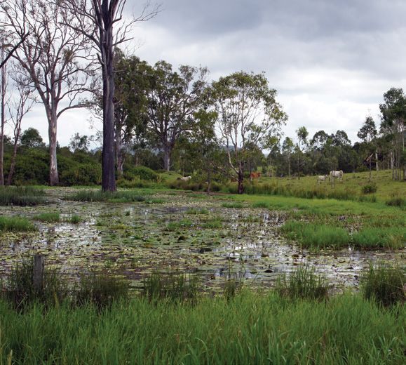
The role of the Flinders Karawatha Regional     Action                                             Responsibility
Panel includes:                                                                                    (lead agency; key partners)
•   preparing the strategy and Environmental
                                                Facilitate coordinated internal (State             DSDIP
    Values and Land Use (EVaLU) maps for
                                                Government) funding bids for landowners to         EHP
    the overall development of the corridor
                                                manage corridor values.
    by collaborating with regional and local                                                       BCC, ICC, LCC, SRRC
    project partners                                                                               Conservation groups
•   overseeing coordination, reporting,                                                            Land care groups
    evaluation and improvement of
    the strategy                                Facilitate coordinated external                    Commonwealth Government
                                                (Commonwealth Government) funding bids for         Conservation groups
•   liaising with state agencies and local
                                                landowners to manage corridor values.
    governments during the assessment of                                                           Land care groups
    development and activities that may                                                            BCC, ICC, LCC, SRRC
                                                Encourage and support landholders to
    significantly constrain the achievement
                                                participate in property management planning        EHP
    of actions
                                                activities for purpose of adopting sustainable
•   monitoring and providing information                                                           Land care groups
                                                land use practices.
    and analysis of EVaLU maps for state
                                                Provide information to private landholders         QORF
    agencies and local governments.
                                                and others on emerging outdoor recreation          EHP
Conservation of the environmental,              markets and support participation.
                                                                                                   Seqwater
social and cultural values will require a
coordinated approach by governments and         Provide information to landholders on              Offset brokers
the community as the corridor encompasses       emerging carbon farming markets and                EHP
a variety of tenures. Sound economies and       support participation.
                                                                                                   BCC, ICC, LCC, SRRC
healthy ecosystems are inter-dependent.
Where community, industry and all levels of     Provide information to landholders on the          EHP
government recognise and agree on common        environmental offsets programs available and       BCC, ICC, LCC, SRRC
nature conservation goals, cooperative          support participation.
                                                                                                   Offset brokers
activity can yield positive results.
                                                Where appropriate, invest offset liabilities,      EHP
Private landholders manage the majority         generated within the South East Queensland
of land and a priority of the strategy is                                                          DSDIP
                                                Bioregion, within the administrative boundary.
to enhance and maintain the capacity of                                                            BCC, ICC, LCC, SRRC
landholders to engage in local actions to                                                          Infrastructure providers
achieve positive environmental outcomes.
                                                Apply the single State Planning Policy strategic   BCC, ICC, LCC, SRRC
There are a variety of incentives available
                                                biodiversity corridor mapping to enable a          DSDIP
to landholders to financially assist property
                                                coordinated and integrated approach to
management, including fencing riparian                                                             EHP
                                                managing offset investment.
areas, weed control and revegetation.                                                              DoD
Ecologically sustainable tourism and                                                               Offset brokers
recreation development has the potential
                                                Identify funding sources/options available to      The Flinders Panel
to broaden the economic base of the
                                                landholders, community groups, councils for
region whilst nurturing and protecting
                                                environmental activities/projects.
its unique natural assets. A considered,
systematic approach is necessary if
optimal economic and environmental
outcomes are to be achieved.
                                                                                                                                 7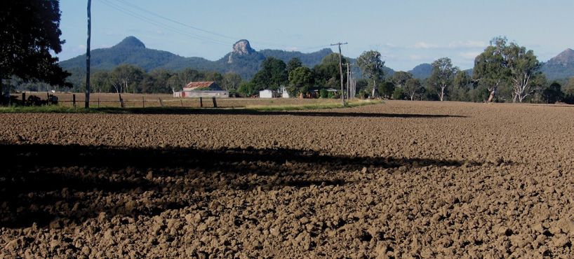
Corridor management
    Biodiversity
       Objective: To preserve and enhance remnant, significant and riparian vegetation
       in viable corridors to enhance biodiversity, and facilitate wildlife movement and
       gene flow.
    Context
    In a region that has lost a large proportion of its vegetation cover in the last 100 years, Flinders
    Karawatha Corridor provides a refuge of enormous importance. It supports 28,786 hectares of
    remnant vegetation (51.2% of the total area) and 31.3% has state biodiversity significance in
    the South East Queensland Biodiversity Planning Assessment.
    Significant areas of conservation estate include the Karawatha Forest, White Rock-Spring
    Mountain Conservation Estate, Flinders-Goolman Conservation Estate, Mt Perry Conservation
    Park, Flinders Peak Conservation Park and the Mt Joyce Recreation Park.
    Twenty-seven Regional Ecosystems are represented and 16 of these have a biodiversity status
    of endangered or of concern. A range of vegetation communities exist, including rocky hills,
    eucalypt forest and wetlands that are home to threatened fauna species, including koalas,
    wallum froglets, powerful owls, brush-tailed rock wallabies and black-breasted button-quails. It
    is nature on the doorstep of Brisbane, Ipswich and Logan cities.
    Vegetated corridors between tracts provide opportunities for gene flow and animal movement
    that can increase flora and fauna population viability. Large numbers of smaller, but significant
    areas of bushland are present and provide vital refuges for wildlife. Activities to connect them to
    the larger tracts, and with each other, will enhance corridor networks in South East Queensland.
    Connectivity of landscapes is recognised as a critical component in maintaining ecosystem
    functionality and meeting community needs. Ecosystems do more than just sustain wildlife.
    Crucial habitats provide ecosystem services that range from enhancing water quality, to
    creating recreational opportunities, to ensuring the pollination of crops. These ecosystem
    services contribute to the sustainability of local and regional communities and the economy of
    South East Queensland.

8
Action Responsibility
(lead agency; key partner)
Identify key areas on public and privately- EHP
owned land for protection and revegetation BCC, ICC, LCC, SRRC
to enhance connectivity and buffer high value
DSDIP
environmental assets.
Encourage local government to utilise funds BCC, ICC, LCC, SRRC
obtained from environmental levies for land EHP
purchases within the administrative boundary.
Encourage and support landholders to BCC, ICC, LCC, SRRC
participate in Land for Wildlife, VCA and Nature EHP
Refuge programs, if available.
Conservation groups
Land care groups
Continue to engage with Australian The Flinders Panel
Government on the future of Greenbank Commonwealth Government
defence training area and seek to enhance the
BCC, ICC, LCC, SRRC
ecological value of the area.
Develop an integrated corridor weed and BCC, ICC, LCC, SRRC
pest management plan to coordinate on DAFF
ground control actions.
Infrastructure providers
Commonwealth Government
Conservation groups
Land care groups
Landowners
Investigate potential for developing an The Flinders Panel
integrated Fire Management Plan for the BCC, ICC, LCC, SRRC
Corridor region.
SEQFBC
QFRS (rural & local)
Landowners
Investigate initiatives to create funding EHP
streams to allow for voluntary purchases
of land.
9Waterways and wetlands
Objective: To maintain or improve the water quality of waterways and wetlands.
Context
Waterways provide important refuges for plants and animals from the potential effects of
climate change. Ecosystem processes, the lifecycles of aquatic species and the distribution
and abundance of aquatic life may be affected where natural flow regimes are disrupted.
The headwaters for the Oxley, Flagstone, Bundamba, Purga and Woollaman Creeks, amongst
others, are located within the mountainous areas of the Corridor. Preservation of the
environmental values of this area is vital for the protection of water quality.
Water resources provide clean water for human consumption, environmental flows, recreation,
and agricultural and industrial uses. Water-based ecosystems and associated riparian areas
provide habitat for many plants and animals. Wetlands filter sediment and excess nutrients
from water, resulting in improved water quality.
Managing waterways and wetlands to control weeds and pests, and the retention of riparian
vegetation, will assist in protecting water quality within the region and for downstream users.
Action Responsibility
(lead agency; key partners)
Manage water quality through the adoption of Infrastructure providers
erosion and sediment control measures during
construction phase.
Ensure compliance for erosion and BCC, ICC, LCC, SRRC, EHP
sediment control.
10Rural land use
Objective: To raise awareness, and encourage the adoption of, sustainable land
management practices by all land managers to meet the needs of existing and
future communities.
Context
Good quality farming land is a limited resource. The protection and sustainable management of
agricultural land is important to safeguard the capacity of the region to produce food, fibre and
other materials for communities.
Land use and development has caused several forms of land degradation and impacts that
need to be addressed. Overuse or irreversible loss of healthy soils could have significant
environmental, economic or social impacts for a region in the future. Healthy soils and high
levels of vegetation cover reduce the movement of excess nutrients and sediment in water
runoff into streams. Soils and the crops and grasslands they support are potentially large
reservoirs for storing carbon.
An important aim of this strategy is to encourage the adoption of land management practices
and rehabilitation measures that address identified problems to sustain longer-term
productivity and reduce environmental impacts. The management of grass cover to manage
soil erosion and landslip is fundamental to the sustainable management of land resources.
By improving land condition, the productive potential of grazing lands is increased and
biodiversity is enhanced.
Action Responsibility
(lead agency; key partners)
Provide information and examples of ‘good practice’, DAFF
when available, that may assist landholders in the Land care groups
growth and sustainability of the agriculture industry.
11Cultural Heritage
Objective: To identify and protect Aboriginal and European cultural heritage values.
Context
Indigenous and European archaeological and culturally significant sites have been identified
within the corridor. A range of planning, legislative and management frameworks are in place
to protect these places. By protecting the heritage, other values inherent in the landscape are
also protected.
Action Responsibility
(lead agency; key partners)
Engage Traditional Owners to identify their Jagera Daran Pty Ltd
aspirations for Aboriginal cultural heritage
EHP
management.
Identify and protect European cultural EHP
heritage values.
BCC, ICC, LCC, SRRC
12Recreation and scenic amenity
Objective: To promote the development of ecologically sustainable recreation
opportunities and maintain scenic amenity.
Context
Existing landscapes provide significant areas of community green space and recreational
opportunity. Mt Joyce Recreation Park at Wyaralong Dam provides a range of water and land Action Responsibility
based recreational opportunities. Bushwalking, mountain biking, horse riding and various (lead agency; key partners)
other outdoor pursuits are undertaken in a number of areas of high scenic amenity. Trail horse Prepare a recreation strategy that: QORF
riding clubs conduct rides on public and private property.
• identifies economic value of Council of Mayors(SEQ)
The scenic amenity is characterised by a network of peaks, creeks, lowland forests, forested nature-based recreational use and BCC, ICC, LCC, SRRC
ridges and semi-cleared valleys. Flinders Peak, Ivory’s Rock, Spring Mountain, Mt Goolman and ecotourism opportunities
Mt Joyce are spectacular geological features close to rapidly urbanising areas. The area is a • identifies key sites for future recreational
gateway to the national parks of the Scenic Rim, including the World Heritage Area-listed Main and ecotourism opportunities that
Range National Park. minimise impacts on corridor values and
Further development of sustainable, nature-based recreational opportunities has the potential respect the rights of existing residents
to contribute substantially to the local economy. Landholders may also benefit from potential • manages existing recreational sites
tourism opportunities in the region. to minimise impacts on other key
corridor values.
13Managing Action Responsibility
(lead agency; key partners)
infrastructure Avoid/reduce impacts on connectivity
and environmental values during strategic
Infrastructure providers
EHP
assets
planning and detailed design stages for
DSDIP
new infrastructure.
BCC, ICC, LCC, SRRC
Local government
Objective: To work with local
government and infrastructure Avoid/reduce impacts on connectivity and Infrastructure providers
providers to minimise the impacts of environmental values during construction,
operation and maintenance of infrastructure.
existing and future infrastructure.
Work with infrastructure providers early in The Flinders Panel
Context planning processes to identify opportunities EHP
Several major infrastructure corridors exist for co-locating compatible infrastructure within
DSDIP
including motorways, major roads, power existing or future sites/corridors.
Infrastructure providers
lines, water and gas pipelines and rail.
Infrastructure intersects wildlife habitat Undertake a review of proposed and DSDIP
in many ways. A Department of Transport existing infrastructure for adverse BCC, ICC, LCC, SRRC
and Main Roads study commissioned in environmental impacts.
EHP
2010 identified 81 locations where artificial
physical barriers exist. Infrastructure providers
Develop a coordinated funding and delivery DSDIP
There are a number of committed
plan to implement the recommendations of Infrastructure providers
infrastructure developments that have the
the Transport and Main Roads Flinders to
potential to impact biodiversity values in the EHP
Greenbank-Karawatha Ecological Corridor
future. Improving the planning, management BCC, ICC, LCC, SRRC
Study (2011).
and usage of common service corridors has
both environmental and economic benefits
and can minimise impacts.
14Reporting, research Action Responsibility
(lead agency; key partners)
and monitoring Develop a robust program logic including
suitable sustainable development indicators
to frame monitoring efforts and inform
EHP
DSDIP
BCC, ICC, LCC, SRRC
Objective: To facilitate coordination of reporting, research and monitoring activities. management interventions.
Context Incorporate the Rapid Condition Assessment The Flinders Panel
into the Monitoring and Evaluation Framework.
Coordinated reporting on actions that deliver on the strategy is essential to assessing how
Integrate existing monitoring activities with EHP
extent and condition of environmental, social and cultural aspects of the strategy change over
the state-wide monitoring, evaluation and DSDIP
time. This is essential to the review and improvement process for the strategy.
improvement framework.
Coordinated reporting and monitoring of actions will allow for a closer assessment of progress The Flinders Panel
Report bi-annually on the progress of actions
towards achievement of the vision and to address challenges.
in the strategy
Developing a coordinated monitoring, evaluation and improvement system will allow for Work with research institutions and corridor The Flinders Panel
integrated feedback on the effectiveness of actions. Data on the condition and extent of the partners to coordinate key research questions,
region’s natural, cultural and social values will be iteratively assessed against the EVaLU maps identify information gaps and promote
so that trends can be established. research and monitoring in deficient areas.
A coordinated monitoring system will also guide the investment of funds, energy and time Develop fauna and flora species recovery The Flinders Panel
to deliver on actions. As evaluation proceeds, adjustments and improvements can be made plans where necessary.
as required.
Ensure major investment projects have DSDIP
Existing landscapes offer the potential for a range of research and monitoring projects, associated monitoring plans and outcomes EHP
including environmental, economic, cultural heritage and social. Significant scientific research from monitoring effort to inform future
has been undertaken and much of this research has been utilised to inform management BCC, ICC, LCC, SRRC
investment.
actions in this strategy. Several major universities have active research programs in the area
and this information is invaluable in guiding management decisions.
It is important that threatening processes are reviewed and that targets or goals are identified
for conserving and improving the region’s values.
15Acronyms
BCC Brisbane City Council
CoM (SEQ) Council of Mayors (SEQ)
DSDIP Department of State Development, Infrastructure and Planning
DAFF Department of Agriculture, Fisheries and Forestry
DoD Department of Defence
ICC Ipswich City Council
LCC Logan City Council
TMR Department of Transport and Main Roads
EHP Department of Environment and Heritage Protection
QFRS Queensland Fire and Rescue Service
QORF Queensland Outdoor Recreation Federation
SRRC Scenic Rim Regional Council
SEQFBC South East Queensland Fire & Biodiversity Consortium
16Appendix 1
Corridor Location Map
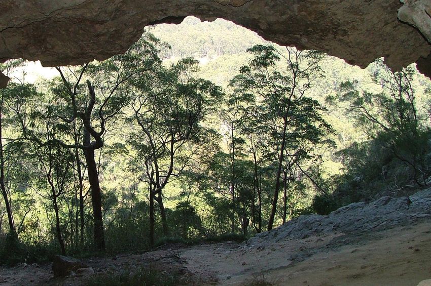
17Photograph index
Lookout to Flinders
Karawatha Forest Karawatha Forest
Karawatha Corridor
Brisbane City Council Brisbane City Council
Environment and Heritage Protection
Rural Scene, looking to Boonah Tuckeroo
Karawatha Forest
Flinders Karawatha Corridor Cupaniopsis tomentella
Brisbane City Council
Ipswich City Council Glenn Leiper
Glossy black-cockatoo
Karawatha Wetlands Brushtailed Rock Wallaby
Sustainability, Environment,
Brisbane City Council Bruce Thomson
Water, Population and Communities
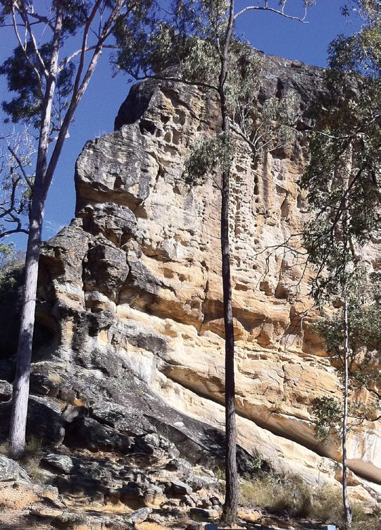
White Rock White Rock Outcrop Karawatha Wetlands
Logan City Council Ipswich City Council Brisbane City Council
Thyme-leafed Honey-myrtle Plunkett Mallee
Rural wetland in the Corridor
Melaleuca thymifolia Eucalyptus cutisii
Environment and Heritage Protection
Brisbane City Council Glenn Leiper
18Flinder Karwatha Corridor Horse riding,
Undullah waterway
Leanne White, Western Trailhead
Logan City Council
Environment and Heritage Protection Seqwater
Stockyards, Harding’s Paddock Powerlines
Karawatha overpass
Leanne White, Flinder Karawatha Corridor
Brisbane City Council
Environment and Heritage Protection Environment and Heritage Protection
Teviot Brook riparian vegetation,
Tullawong cave overhang Exclusion fencing
Flagstone
Jagera Daran Pty Ltd Logan City Council
Logan City Council
Green-thighed frog Rural Scene, looking to
Recreation within the Corridor
Litoria brevipalmata Flinders Karawatha Corridor
Scenin Rim Regional Council
Steve Wilson Peter Filet
Koala
Mountain biking Mt. Flinders
R Booth,
Scenic Rim Regional Council Ipswich City Council
Logan City Council
19For more information about this strategy please email Esres.Southernescbranch@ehp.qld.gov.au.
You can also read