From Silos to FAIR Services - Interoperable application of geospatial data for longitudinal surveys in the Social Sciences - DIW Berlin
←
→
Page content transcription
If your browser does not render page correctly, please read the page content below
From Silos to FAIR Services
Interoperable application of geospatial data for longitudinal surveys in the
Social Sciences.

Peter Löwe (ploewe@diw.de) , Tobias Gebel, Hans Walter Steinhauer
EGU 2020 - ESSI 3.5 - EGU2020-18956
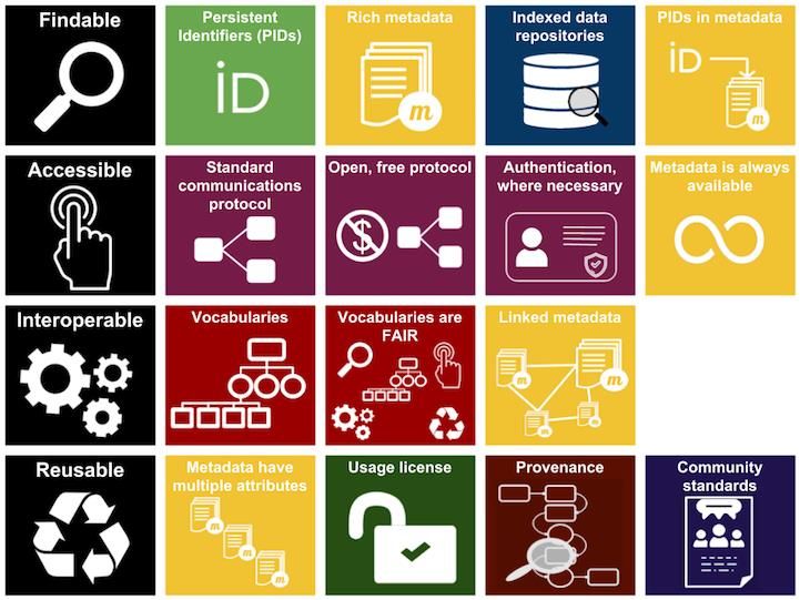
Setting the scope: FAIR
Setting the scope: FAIR
Setting the scope: FAIR
The Challenge

• Goal: Application of Building Model Data for Germany provided by
  the Federal Agency for Cartography and Geodesy (BKG) .

• .. in the Social Sciences to optimize annual longitudinal surveys.
                                                                                                                  By SangyaPundir - Own work, CC BY-SA 4.0,
                                                                                                                  https://commons.wikimedia.org/w/index.php?curid=53414062

• Challenge:
  •   Data is provided as state-level file-based silos (no web service)
  •   Data reduction necessary to focus on areas of interest.
  •   No reference implementation based on Free and Open Source (FOSS) tools.
• Approach:
  •   Enable FAIR data use by introducing a standard-based FOSS-based service layer.

                                                                  https://www.bkg.bund.de/SharedDocs/Produktinformationen/BKG/DE/P-2019/190211_LoD1.html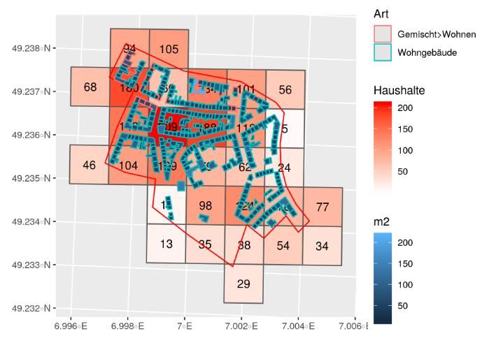
Application Scenario:
           Residential buildings for household-based surveys
•   The Socio-economic Panel (SOEP) as part of the German
    Institute for Economic Research (DIW Berlin) provides      Layout, Lot size, building function
    longitudinal data on persons living in private
    households (15.000 households) across Germany.

•   SOEP samples households in certain neighborhoods
    within cities, areas of the so called „Soziale Stadt“
    (Social Integrative City)
                                                                                       Source: Steinhauer (2020)

•   Regional clustering based on census tile grid              Census grid clipping

•   Random sampling based on official address data.

•   New: Filtering by building model attributes for building
    function to seperate residential buildings from
    commercial buildings.
                                                                                         Source: Steinhauer (2020)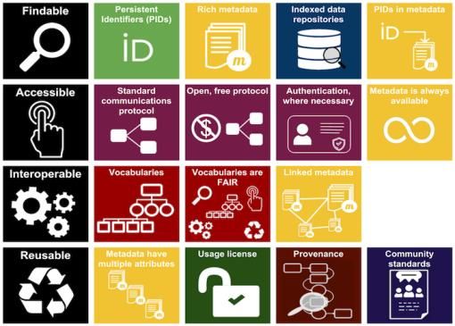
Hands-on Challenge: Working with Data Silos
• Data is provided as silos on State-level as compressed
file archives.
• Decompressing thousands of XML-files (CityGML) on a
desktop computer leaves a large storage footprint.
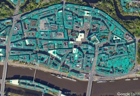
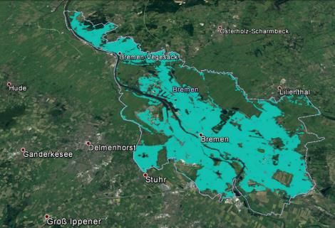
• Need to convert building polygons into other Building models for the State of
geospatial formats – on State level (KML, ESRI-Shape Bremen rendered in GoogleEarth
are bad ideas) ?
• The German CityGML-dialect extends the standard
OGC definition.
• Reality Check: Social Scientists use off-the-shelf
statistical software (R, Stata) on desktop computers
and are not by default versed in geoinformatics- and
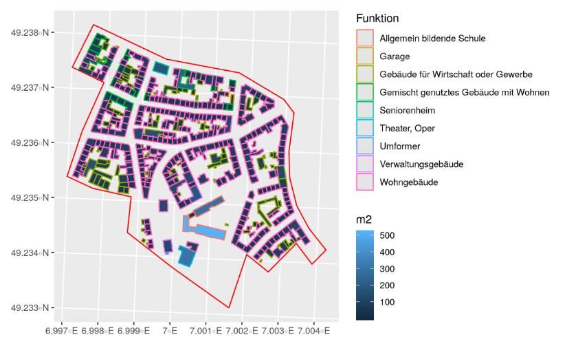
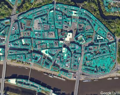
scripted file-processing. Building models for the State of
Bremen rendered in QGIS (via a
WMS)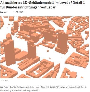
Solution: WMS-Service Reference Implementation

New: FOSS-based service layer
• Ingest: gdal/ogr (GMLAS - Geography   Quelle: Biljecki, Ledoux, and Stoter (2016)

  Markup Language (GML) driven by
  application schemas)
• Backend: PostGIS
• Service-Frontend: MapServer (OGC-
  WxS)

Enabling FAIR reuse in Social Science
desktop computing environents :
• R mit sf (Pebesma, 2018), tidyverse
   (Wickham, 2017)
• STATA
• QGIS
                                                                                      WMS   WFS   WCS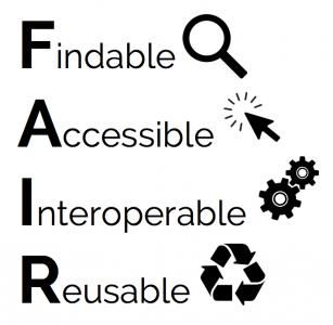
Results & Outlook
A reference web-service implementation built on open source software was
implemented.

Survey studies at DIW/SOEP can now harness official geospatial building models to
optimise annual survey planning and execution.

Todo:
• Public documentation of know-how about gdal/ogr-based wrangling for german-style
  CityGML data through OSGeo (umbrella foundation for the gdal/ogr-project).

• Extend FOSS-based reference implementation at DIW for WFS and WCS.

• Discuss with BKG options for an official web-based access to the data.
Sources
•   Census
•   https://www.zensus2011.de/DE/Home/Aktuelles/DemografischeGrunddaten.html

•   Georeferenced Adress Data
•   http://gdz.bkg.bund.de/index.php/default/georeferenzierte-adressdaten-ga.html

•   3D Building Models
•   https://gdz.bkg.bund.de/index.php/default/digitale-geodaten/sonstige-geodaten/3d-gebaudemodelle-lod1-deutschland-lod1-de.html

•   Biljecki, Filip, Hugo Ledoux, and Jantien Stoter. 2016. “An Improved Lod Specification for 3D Building Models.” Computers, Environment and
    Urban Systems 59. Elsevier: 25–37. https://doi.org/10.1016/j.compenvurbsys.2016.04.005.

•   Pebesma, Edzer. 2018. “Simple Features for R: Standardized Support for Spatial Vector Data.” The R Journal 10 (1): 439–
    46. https://doi.org/10.32614/RJ-2018-009.

•   R Core Team. 2019. R: A Language and Environment for Statistical Computing. Vienna, Austria: R Foundation for Statistical
    Computing. https://www.R-project.org/.

•   Steinhauer, H. W. (2020). Nutzung geokodierter Zensus- und Gebäudedaten zur Ziehung und Gewichtung von Haushaltsstichproben. Vortrag
    auf dem 14. Workshop der Panelsurveys im deutschsprachigen Raum, Mannheim.

•   Wickham, H. (2017). tidyverse: Easily Install and Load the 'Tidyverse'. R package version 1.2.1. https://CRAN.R-project.org/package=tidyverse
Vielen Dank für Ihre Aufmerksamkeit. DIW Berlin — Deutsches Institut für Wirtschaftsforschung e.V. Mohrenstraße 58, 10117 Berlin www.diw.de Redaktion Peter Löwe (ploewe AT diw.de) Tobias Gebel, Steinhauer
You can also read