Future GBAS Processing - Do we need an ionosphere-free mode?
←
→
Page content transcription
If your browser does not render page correctly, please read the page content below
Future GBAS Processing – Do we need an ionosphere-free mode?
           Authors: Michael Felux, Mihaela-Simona Circiu, Daniel Gerbeth, Maria Caamano

                                      Email: Michael.felux@dlr.de

                                   German Aerospace Center (DLR)
                                         Muenchenerstr. 20

                                             82234 Wessling
                                                Germany

           Keywords: GBAS, dual-frequency, multi-constellation, augmentation system, Ifree

Abstract

The Ground Based Augmentation System (GBAS) is a landing system for aircraft. It consists of
carefully sited reference receivers at an airport, generating corrections for the navigation signals from
Global Navigation Satellite Systems (GNSS). Along with the corrections, integrity parameters are
generated and transmitted to arriving aircraft that allow the aviation users to bound their residual
position errors after applying the corrections. Currently, corrections are generated for the GPS
constellation and the L1 frequency. However, with the ongoing buildup of the European Galileo, the
Chinese BeiDou and the modernized Russian Glonass the number of available GNSS constellations is
increasing. This provides the opportunity to design systems more robust against disturbances, such as
ionospheric scintillation effects, through a larger number of available ranging sources. Furthermore, all
Galileo and the latest generation of GPS satellites feature signals in the L5 band that can be used by
aviation. Therefore, it is possible to apply dual frequency techniques for mitigation of the ionospheric
gradient threat. This paper discusses the advantages and disadvantages of using an ionosphere free
combination of the signals for positioning and if such a mode for a future generation of GBAS should
be developed.

Introduction

The Ground Based Augmentation System (GBAS) is a guidance system for precision approaches and
landings of aircraft. A reference station, consisting of typically four reference receivers at carefully
surveyed locations at an airport, provides corrections for navigation signals from Global Navigation
Satellite Systems (GNSS). Along with these corrections integrity parameters are broadcast such that
the airborne receivers can correct their GNSS measurements and calculate bounds to the residual
position errors. Currently, there are ground stations commercially available and already in use at
several locations throughout the world including Bremen and Frankfurt (Germany), Newark and
Houston (United States), Sydney (Australia), Malaga (Spain) and Zurich (Switzerland). These ground
stations enable approaches under CAT-I weather conditions corresponding to the GBAS Approach
Service Type (GAST) C in GBAS phraseology. Standards for GAST D (i.e. the service type
supporting also CAT-II/III approaches) were finalized at the end of 2016 and first stations may be
operational in the 2019 to 2020 timeframe [1].

All those service types, however, rely only on the GPS constellation and signals in the L1 frequency
band. Therefore, the measures to protect users against ionospheric disturbances in GAST C and D can
result in limited availability, especially in equatorial regions with highly active ionospheric conditions.
Since the introduction of the latest generation of GPS satellites (Block IIF) and with the introduction of the European Galileo constellation, a growing number of satellites offering navigation signals on a second usable frequency are becoming widely available. With these it is possible to form a dual- frequency combination of the measured pseudoranges to remove the ionospheric delay and thus make GBAS robust against ionospheric gradients. Increasing the number of navigation satellites through the use of dual-constellation algorithms furthermore provides a significantly increased robustness against ionospheric scintillations and associated loss of lock events. As the protection against the ionospheric gradient threat requires a significant amount of monitoring or conservative error bounding, one of the new processing modes of a future dual frequency dual constellation (DFDC) GBAS could be an ionospheric free (Ifree) combination of the ranging signals. This combination of signals from two different frequencies allows the removal of the ionospheric delay (except for higher order effects) and thus effectively eliminates the gradient threat. However, this comes at a cost of significantly increased residual noise in the position solution. The Ifree solution combines code measurement from two frequencies and thus also the residual errors contained in those measurements. This results in rather large position error bounds that are calculated for integrity assurance. To date there is no clear way defined how future dual frequency and multi constellation GBAS processing and integrity monitoring will be accomplished. Currently, several different concepts are under investigation. The goal is to enable new processing modes which overcome the challenges that the ionosphere poses for current GAST C/D GBAS. At the same time it is mandatory to maintain backwards compatibility to those service types. Furthermore, the architecture needs to be simple to avoid too many different modes and thus keep the standardization and certification efforts as small as possible. In case the airborne receiver is capable of tracking L5/E5a signals, positioning can be performed based on a single frequency mode (either L1/E1 or L5/E5a), however, with dual frequency monitoring for ionospheric gradients [2]. As we showed in previous studies, the single frequency modes provide a better nominal performance than a dual frequency positioning [3], [4], [5]. In this configuration the better nominal performance can be kept maintained in most cases. Should an ionospheric gradient situation be detected by the dual frequency airborne monitoring a switch to an Ifree positioning can be performed. In this paper, after a short discussion of the ionospheric threat, we review the current candidates for future GBAS processing modes and then take a closer look at the impact of ionospheric disturbances on different processing schemes. By reviewing the different threat types and the reaction of the different processing modes we try to answer the question if an Ifree processing mode is necessary. The ionospheric threat Before discussing future processing modes and their implications, a short review of the ionospheric threat to GBAS users may be helpful. There are two main threats coming from ionospheric disturbances: large scale ionospheric gradients (so-called travelling ionospheric disturbances (TIDs)) and smaller scale irregularities mostly in equatorial regions (so-called plasma bubbles). The large scale ionospheric fronts are described by the so-called “wedge model” that is depicted in Figure 1, assuming a linear change in the ionospheric delay. The parameters defining the gradient are the slope of the gradient g , the width w , the speed v and a maximum change in delay I= w ⋅ g . These large scale gradients could potentially cause navigation errors in a differential GNSS architecture such as in GBAS, however, they occur very rarely. In the assessment of the ionospheric threat space for Germany only one gradient with a slope larger than 100 mm/km was observed within one solar cycle
(11 years) [6]. In South Korea four gradients larger than 100 mm/km were observed in a four year
period (2000-2004) around the maximum of the solar cycle [7].

                              Figure 1 The ionospheric gradient "wedge model"

Similar in effect for users of a differential GNSS, but different in their characteristics are the so-called
plasma bubbles. These are small-scale depletions in the ionosphere that are mostly observed in
equatorial regions. They occur almost on a daily basis after sunset and show much steeper slopes in
the ionospheric delay. In a recent study about the Brazilian ionospheric threat space gradients as large
as 850 mm/km were observed [8]. In another very recent study about the Asia-Pacific region,
gradients up to 518 mm/km were found at Ishigaki Island in Japan [9]. These plasma bubbles are
usually accompanied by ionospheric scintillations. These scintillations may lead to an increased noise
in the measurement degrading the accuracy of the GNSS-based ranging. Stronger scintillations may
even cause a loss of lock of the signal and render affected satellites unavailable for navigation. The
maximum difference in ionospheric delay between the depletion and the nominal ionospheric state
around it is, however, typically more limited than in the case of the large scale TIDs.

Integrity assurance today

The GBAS service types C and D both were developed to safely protect airborne users from all kinds
of ionospheric threats. In both service types the ground station provides integrity parameters that allow
the airborne user to calculate bounds on the residual position error after applying the corrections.
These protection levels are defined for the vertical and the lateral domain. They are compared against
an allowable maximum value, the alert limit, in order to assess if the current navigation performance is
sufficient for the desired operation. The discussions here are limited to the vertical domain since these
requirements are harder to fulfill. The vertical protection level (VPL) is defined as

                                                      N
                             =
                             VPLH 0 K ffmd           ∑s      2
                                                             vert , i
                                                                        ⋅ si2 + Dv                      (1)
                                                      i =1

with K ffmd the fault-free missed detection multiplier given by the allocated integrity risk as inflation
factor for a Gaussian distributed uncertainty, Dv is the vertical position difference between the 30
seconds smoothed and 100 seconds smoothed position estimate in GAST D, and 0 in GAST C, svert ,i
the projection factor for satellite i from the pseudorange into the position domain and σi the residual
uncertainty associated with the corrected pseudorange measurement for satellite i . The total
uncertainty σi is composed of an uncertainty due to residual noise and multipath in the corrections
σ gnd , residual noise and multipath from the airborne pseudorange measurement σair , and
uncertainties accounting for the tropospheric and nominal ionospheric conditions ( σtropo and σiono )
and is given as
σσσσσ
i =
2
gnd , i + air , i + tropo , i + iono , i
2 2 2 2
(2)
In addition to the nominal conditions, further mitigation methods for non-nominal ionospheric
gradients had to be included into GBAS in order to mitigate any potential threat. The integrity
assurance concept in GAST C assumes the presence of the worst ever observed ionospheric gradient in
a specific region in a process called geometry screening in the ground system. Should errors larger
than a predefined threshold be possible to occur at the airborne receiver, the ground station artificially
inflates the integrity parameters. This is done in such a way the resulting protection levels would be
larger than the alert limit and thus that particular satellite geometry leading to those larger errors
would be unavailable to a user [10]. Assuming the worst case gradient present at all times is of course
a very conservative strategy but for mid-latitudes it doesn’t affect the availability much. However, if
gradients as large as observed in equatorial regions were to be bounded with the same concept, the
availability of the system would suffer severely and degrade to values well below operationally
acceptable minima [11].
In the GAST D concept the ionospheric monitoring task is shared between the ground station and the
airborne system. In addition to the protection level calculation, several monitoring algorithms were
included in the ground station, as well as in the airborne system. The Ionospheric Gradient Monitor
(IGM) in the ground station monitors for absolute ionospheric gradients. It is, however, also
susceptible to tropospheric effects that may trigger false alarms on hot and sunny days [12].
Furthermore, Code-Carrier Divergence monitoring is performed in the ground system as well as in the
airborne system in order to detect temporal ionospheric gradients. Finally, the board system applies
two different carrier smoothing time constants to smooth the pseudorange measurements (30 seconds
and 100 seconds). The difference between them is compared in order to detect the effect of
ionospheric gradients that build up differently in both smoothing filters. All those monitors can jointly
protect a user from otherwise potentially dangerous situations caused by ionospheric effects. However,
this concept was only validated for a maximum gradient size of 550mm/km and therefore needs
further validation if it should also be used in equatorial regions where gradients up to 850mm/km were
observed. Furthermore, the sensitive IGM requires a very specific spacing between the reference
antennas of the GBAS and thus often causes issues with available space for siting the ground station
within an airport. The problem of ionospheric scintillation leading to loss of lock may have an impact
on the satellite geometry available for navigation. Using only a single constellation, this may weaken
the geometries significantly, resulting in increased protection levels.
Potential of DFMC GBAS
While GAST C and GAST D are solutions that are fully developed and provide the required safety,
achieving sufficient availability for potential users outside the mid-latitude regions is still a challenge.
With the increasing number of satellites from other constellations, such as the European Galileo, the
Chinese BeiDou, the Russian Glonass or the Japanese QZSS a large number of additional satellites are
becoming available for navigation. Using signals from other constellations than just GPS increases the
total number of satellites that can be used for positioning. It improves the geometric diversity of the
satellites for a user and greatly improves robustness against disturbances, such as plasma bubbles and
ionospheric scintillations. While one or even few satellites may be affected and discarded from the
navigation algorithms, having a large number of satellites available dramatically increases the chances
that the remaining satellites still allow for a good position estimate associated with residual errors thatcan be safely bounded within acceptable limits [13]. It is generally accepted that the use of more than
one constellation improves navigation performance and makes GBAS (as well as any other GNSS-
based navigation technique) more robust.
Furthermore, the latest generation of GPS (Block II F) introduced a second civil frequency usable for
aviation purposes in the L5 band. All Galileo satellites also offer signals in the E1 and E5a band that
are interoperable with GPS. As the ionospheric delay is frequency dependent, receiving two signals on
different frequencies from the same satellite allows for a good estimation or even a complete removal
of the ionospheric delay. Currently, there are different options for future GBAS service types under
discussion. The two most promising ones shall be described and discussed more in detail now.
Option 1: Ionosphere free combination
The first option under discussion is the use of the ionosphere free combination of the signals on L1
and L5. It is formed as
f L21 r L1 − f L25 r L 5
r Ifree , L1L 5 = (3)
f L21 − f L25
where f L1 and f L 5 are the center frequencies of the L1 and L5 band, respectively, and ρ L1 and ρ L 5 are
the respective smoothed pseudorange measurements for the two frequencies.
Using this combination of the signals for positioning eliminates the ionospheric gradient threat that
was one of the major concerns in the development of GBAS to this date. With the Ifree combination
the effect of the ionosphere is removed at the airborne receiver and thus the concern of potentially
erroneous corrections due to spatial differences between the ground station and the airborne user is
eliminated. On the downside, the Ifree combination also combines the residual noise and multipath in
the pseudorange measurements on both frequencies. This leads to an increased uncertainty in the
position solution and degrades the nominal positioning performance compared to single-frequency
positioning methods. The problem of the increased noise gets more pronounced when the residual
uncertainties have to be bounded in the protection level concept, as conservative bounds on the errors
on both frequencies have to be assumed and then combined. Due to the fact that the random errors
may constructively interfere the residual noise in the airborne measurements is
2 2
f L21 2 f L25 2
=σσσ 2 2
+ 2 2
(4)
f L1 − f L 5 f L1 − f L 5
air , Ifree air , L1 air , L 5
and thus significantly larger than the residual noise that is bounded in the single frequency case.
Figure 2 shows experimentally derived curves for the residual noise and multipath for GPS, Galileo
single frequency and the Ifree combinations. These values were derived from flight trials on DLR’s
Airbus A320. Note that the curves for GPS and Galileo are quite similar for satellite elevations above
20°. However, below that results show a better performance of the Galileo signals which may be
attributed to the different modulation used on E1 (BOC(1,1) compared to BPSK(1) on GPS L1). The
curves shown in black are the models for the Ifree combination. The significant increase in the residual
uncertainty compared to the single frequency L1 case described in Equation (4) is clearly visible.Figure 2 Residual uncertainty due to noise and multipath as a function of satellite elvation for single frequency GPS
and Galileo, as well as for the Ifree combination
Just as the σ air , Ifree , the σ gnd , Ifree increases in the same way by the combination of the errors from two
signals. The σ iono term in Equation (2) is eliminated, as there is no ionospheric decorrelation between
the ground and the airborne user if the ionospheric delay is eliminated. Note, however, that the σ iono -
term only bounds the nominal decorrelation. It is dependent on the distance between the user and the
GBAS ground station and therefore very small in the proximity of an airport. The σ tropo -term remains
unchanged due to the fact that the tropospheric decorrelation is not a frequency dependent quantity.
The overall resulting σ i in Equation (2) is therefore significantly increased for the Ifree case as
compared to the single frequency case. Using at least two constellations, the increase in noise may be
somewhat compensated by the effect of having an improved satellite geometry and thus smaller values
of svert in Equation (1). This may lead to protection levels that are comparable in size to what we can
obtain today in GAST C and GAST D.
The obtained protection against ionospheric gradient threats in the Ifree mode is therefore traded
against a worse nominal performance (in positioning accuracy and protection level performance) as
compared to the single frequency case. Furthermore, an effective protection against ionospheric
disturbances requires simultaneous tracking of the signals on both frequencies. In the presence of
scintillations, the probability of tracking both signals is reduced compared to the probability of
tracking just the L1 signal. Therefore, under scintillation conditions, there may not even be a benefit of
using the Ifree mode if it cannot be ensured that both signals are tracked continuously.
Option 2: SFDC L1
A second option for a future GBAS service type is based on using only single frequency (SF) but dual
constellation (DC) measurements (wherever possible) for positioning. The second frequency would
then be used for ionospheric monitoring purposes. In [2] we showed how such a monitoring could be
performed and safely protect users against the threat of ionospheric gradients.
The advantage of the single frequency mode is that only the residual noise and multipath on one
measurement needs to be bounded in the protection level calculation, just as it is the case in GAST C
and GAST D today. The remaining uncertainties σ gnd and σ air remain approximately as they are
today (assuming 100 seconds code-carrier smoothing) and thus significantly smaller than in the Ifree
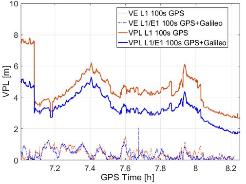
case. Using dual constellation measurements wherever possible also decreases the svert -factors inEquation (1), just like in the dual constellation Ifree case. The σ iono -term would have to be considered again in the single frequency case as the nominal decorrelation of the ionospheric delay would again affect the user. Note again, however, that the contribution of the nominal decorrelation is small for short distances between aircraft and airport. Now if for the ionospheric monitoring dual frequency methods are applied, the same problem of increased noise in the dual frequency measurements as in the Ifree case occurs. The big advantage is, however, that the nominal positioning performance, and thus the protection level performance is not affected. The additional noise and multipath errors only have to be accounted for in the derivation of the monitoring threshold in the dual frequency ionospheric monitor. Furthermore, not only additional noise and multipath occur, but also frequency dependent hardware biases. Just as the additional noise and multipath, they only need to be accounted for in the ionospheric monitor, but not in the positioning when continuing to use single frequency methods there. Finally, the effect of ionospheric scintillations of course also affects the dual frequency monitoring. Just like in the Ifree-case, a continuous tracking of the signals on both frequencies is necessary in order to ensure a reliable detection of any potentially dangerous effect of ionospheric gradients. Loss of lock in scintillation conditions on either frequency would therefore immediately result in a failure of the monitor and thus that particular satellite would need to be removed from the position solution. However, the same is true for the Ifree-positioning case, so that in scintillation conditions both concept are equally vulnerable against the loss of signals. Discussion and conclusions The description of both processing modes already hinted at the conclusion that the authors do not see a substantial benefit for the use of an Ifree positioning mode. The Ifree mode suffers from the combination of two noisy signals and results in worse nominal positioning performance, and therefore also in decreased performance in terms of protection levels. The single frequency positioning mode in combination with a dual frequency monitoring can provide effective protection against ionospheric gradients as well, however, with significantly better nominal performance. Both modes would benefit from using at least a second constellation, as the geometry of the satellites would improve. For the single frequency mode, using only one constellation seems to be a viable option, as the nominal performance and thus the nominal protection levels would be very similar to today’s GAST C and GAST D performance. A comparison between the vertical errors and vertical protection levels for the single constellation (red) and dual constellation case (blue) from a flight trial are shown in Figure 3. For the Ifree mode, the protection level performance will probably require a second constellation in order to reach sufficiently high availability. The improved geometry would then compensate for the increased residual noise and uncertainty in the pseudorange measurements. Figure 4 shows a comparison of the VPLs as calculated during one flight trial conducted at the German Aerospace Center. It can be seen that in the beginning at the end of the flight when the aircraft was close to the airport, the single frequency protection levels (blue for L1/E1, green for L5/E5a) are smaller than the Ifree protection level (shown in black).
Figure 3 Comparison of vertical errors (VE) and vertical protection levels (VPL) for single and dual constellation
                                                      GBAS

These time periods are the most important ones as the best navigation performance is required when
the aircraft is about to land. At larger distances larger protection levels are not much of a problem. At
around 7.4h both single frequency protection levels exceed the Ifree VPL. This occurs during a time
when the aircraft was far away from GBAS ground station. Due to the increase of the σiono as a
function of distance, this contribution becomes dominant in the overall VPL and thus the error
bounding is more challenging in the single frequency cases. Note, that also the effect of the
ionospheric decorrelation is larger on the L5 frequency than on L1. Therefore, the L5 VPL increases
beyond the L1 protection level, even though the residual noise and multipath on L5 is smaller than on
L1.

           Figure 4 Comparison of VPL for Ifree, single frequency L1 and single frequency L5 processing

Both modes are equally vulnerable against the effect of ionospheric scintillations as in both cases a
continuous tracking of the signals on both frequencies is essential. In a single constellation scenario,
loss of lock or discarding potentially unsafe pseudorange measurements quickly degrades navigation
performance as the geometry may be weakened severely. Using at least two constellations greatly
improves the robustness of the system against scintillations by adding more redundancy to the
navigation solution such that loss of one or even several satellite signals may not have a big enough
impact to render GBAS unavailable.

Finally, also the effort for standardization and validation would be greatly reduced in the case of single
frequency positioning, as most of the work that has been done for current systems can be reused. Any
issues related to inter-frequency issues that may arise also in the future due to more detailed studies would then only impact the ionospheric monitoring threshold but not the overall positioning. In the end, however, it should also be noted that the airborne GBAS unit will not only be dedicated to GBAS but the same receiver will most likely fulfill a variety of other tasks in different phases of flight. Depending on the positioning modes used and validated for other applications and depending on the exact implementation chosen by a manufacturer, the choice of mode will also depend on the overall integration concept of the avionics. In the end it is not only a scientific question but also a commercial decision what is economically the best choice for a given piece of hardware.
References

[1] ICAO, Proposed Amendment to International Standards and Recommended Practices -
    Aeronautical Telecommunications - Annex 10 to the Convention on International Civil Aviation -
    Volume I - Radio Navigation Aids, 2016.

[2] M. Felux, M.-S. Circiu, J. Lee und F. Holzapfel, „Ionospheric Gradient Threat Mitigation in
    Future Dual Frequency GBAS,“ International Journal of Aerospace Engineering, Bd. 2017, pp.
    1-10, 2017.

[3] S. Circiu, M. Felux, P. Remi, B. Belabbas und S. Pullen, „Evaluation of Dual Frequency GBAS
    Perfromance using Flight Data,“ in Proceedings of the ITM 2014, 2014.

[4] M.-S. Circiu, M. Felux, B. Belabbas, M. Meurer, J.Lee, M. Kim und S. Pullen, „Evaluation of
    GPS L5, Galileo E1 and Galileo E5a Performance in Flight Trials for Multi Frequency Multi
    Constellation GBAS,“ in Proceedings of the ION GNSS+ 2015, 2015.

[5] D. Gerbeth, M.-S. Circiu, M. Caamano und M. Felux, „Nominal Performance of Future Dual
    Frequency Dual Constellation GBAS,“ International Journal of Aerospace Engineering, Bd.
    2016, pp. 1-20, 2016.

[6] C. Mayer, B. Belabbas, T. Pannowitsch, N. Jakowski, M. Meurer, W. Dunkel und O. Weber,
    „Ionosphere Threat Space Model Assessment for GBAS,“ in Proceedings of the ION GNSS 2009,
    2009.

[7] M. Kim, Y. Choi, H.-S. Jun und J. Lee, „GBAS ionospheric threat model assessment for category
    I operation in the Korean region,“ GPS Solutions, Bd. 19, pp. 443-456, 2015.

[8] J. Lee, M. Yoon, S. Pullen, J. Gillespie, N. Mather, R. Cole, J. R. Souza, P. Doherty und R.
    Pradipta, „Preliminary Results from Ionospheric Threat Model Development to Support GBAS
    Operations in the Brazilian Region,“ in Proceedings of ION GNSS+, 2015.

[9] S. Saito, S. Sunda, J. Lee, S. Pullen, S. Supriadi, T. Yoshihara, M. Terkildsen und F. Lecat,
    „Ionospheric delay gradient model for GBAS in the Asia-Pacific region,“ {GPS} Solutions, Bd.
    21, pp. 1937-1947, 9 2017.

[10] J. Lee, J. Seo, Y. S. Park, S. Pullen und P. Enge, „Ionospheric threat mitigation by geometry
     screening in Ground-Based Augmentation Systems,“ Journal of Aircraft, Bd. 48, pp. 1422-1433,
     2011.

[11] M. Yoon, D. Kim, J. Lee, S. Rungruengwajiake und S. Pullen, „Assessment of Equatorial Plasma
     Bubble Impacts on Ground-Based Augmentation Systems in the Brazilian Region,“ Proceedings
     of the 2016 International Technical Meeting of The Institute of Navigation, pp. 368-379, 2016.

[12] J. McDonald, D. Weed und B. Johnson, „WP16 - Observed Nominal Atmospheric Behavior
     Using Honeywell’s GAST D Ionosphere Gradient Monitor,“ 2014.

[13] M. Caamano, M. Felux, M.-S. Circiu und D. Gerbeth, „Multi-constellation GBAS: how to benefit
     from a second constellation,“ in Proc. of the IEEE/ION PLANS , Savannah, 2016.
You can also read