Geography Summer Independent Learning Summer 2021 - New College Pontefract
←
→
Page content transcription
If your browser does not render page correctly, please read the page content below
Geography
Summer Independent Learning
      Summer 2021.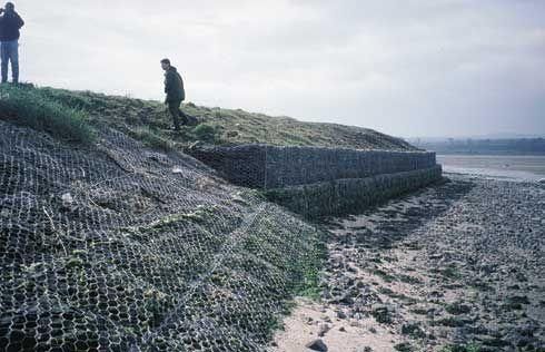
We study 6 different topics in A Level Geography.
                                 In order for you to gain some basic knowledge and understanding of what
                                 our A level course is about, have a go at completing the following
tasks/answering the questions that are taken from the A level specification.
How many can you do? Some are trickier than others.
(You will be quizzed on some or all of these when you start college)
You can present your work in any way that you want.

                Human Geography                                   Physical Geography
                 Changing places                             Coastal systems and landscapes

    1. Give examples of what ‘endogenous                1. List and explain as many coastal processes
       factors’ and ‘exogenous factors’ mean in            as you can.
       relation to places.
                                                        2. Draw and annotate a cross section of a
    2. How do you think an ‘outsiders’ (someone            saltmarsh.
       from outside Doncaster) feelings about
       Doncaster might be different to an               3. Explain how sea level change has affected
       ‘insiders’ (someone that lives in Doncaster)        the island nation of Tuvalu.
       feelings?

    3. List three TNCs (Transnational Companies)
       that you find in Doncaster.

       Global systems and global governance                              Hazards

    1. What does globalisation mean?                    1. List and explain the different tectonic
                                                           plate boundaries.
    2. Find an example of a ‘global commons’.
                                                        2. Find out and explain what is meant by the
                                                           ‘Hazard Management Cycle’.

                                                        3. Are tropical storms becoming more
                                                           damaging? Explain your thoughts.

                 Resource security                                  Water and Carbon

    1. Explain what is ‘grey water’ is.                 1. List the places that water is stored in (and
                                                           around) the planet.
    2. How is the consumption (use of) of water
       being managed in the UK?                         2. List the places that carbon is stored in
                                                           (and around) the planet.
    3. How are countries trying to create more
       sustainable energy supplies?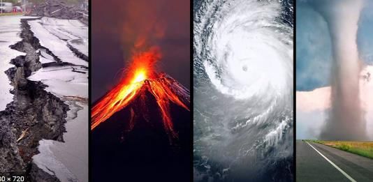
A Level Geography Summer Independent Learning
Part 1- COASTS
Checklist. Upon completion of all tasks in Section 1 and 2 -
I can explain and evaluate different methods of coastal management.
I can describe and give reasons for sea defences in Heysham, Morecambe Bay.
I can recall key facts about the coastal management case study.
I understand the threats to Venice in the past, present and future.
I can explain and find evidence for sea level rises in Venice in the context of the global picture.
I can evaluate the different approaches to protect Venice from rising sea levels.
My work is A Level ready; a range of ideas are explained and developed in detail;
keywords/vocabulary is accurately used throughout; it has clear headings and sub-headings.
1 Coastal Management – Human intervention in coastal landscapes
Coastal management is defence against flooding and erosion, and evaluating the techniques that stop
erosion to protect land. Coastal zones occupy less than 15% of the Earth's land area, while they host more
than 45% of the world population.
Traditional approaches to coastal flood and erosion risk: hard and soft engineering. Sustainable approaches
to coastal flood risk and coastal erosion management: shoreline management/integrated coastal zone
management.
What do I have to do?
Your independent learning is to research 6 different coastal hard engineering strategies – provide
a description of how the management work within the coastal system and research the
effectiveness (advantages and disadvantages) of these different methods.
Create a case study profile of the coastal town of Heysham, Morecambe Bay in Lancashire as this
is an illustrative example of the use of hard engineering. It includes a mix of traditional hard
engineering strategies with a mix of more contemporary methods to improve the potential for
sustainable management.
How do I do it?
Use the following tables as a guide to help you organise your research and work.
This should take you approximately 3-4 hours.
You can present your case study profile in any way you want but it will need handing in within your
first week of lessons.
Please use some of the suggested resources at the bottom of this page
Why do I have to do it?
A Level geography is about being able to investigate and learn new theories and concepts.
An A Level geographer needs to be able to be able to think holistically and apply theory to real life.
You will be tested on your knowledge and understanding of different coastal management and be able to
evaluate the importance of coastal management in Morecombe and Heysham.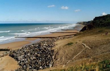
Task 1
Create a table or mind map based on the table below, explaining how each strategy protects the coasts,
often each strategy is large scale and costs a significant amount of money. Your task is to independently
research the specific purpose of each strategy and the effectiveness within the coastal system. Detailed
paragraph not one-word answers.

Task 2
Create a case study profile of the material you have learnt on Hard engineering: Heysham. It must include
the following information:
   1. Background information – Why do Heysham and Morecambe need protecting?
   2. The council has selected ‘Hold the line’ management. Explain this strategy and why they have
      selected this.
   3. What Council is in charge of this management?
   4. What type of management schemes does Heysham and Morecambe use? Suggest why each
      strategy has been used in each location.
   5. How many phases were in this comprehensive improvement scheme and when did the programme
      take place?
   6. Extension - Suggest how these strategies will be challenged by future sea level rises – how future-
      proof is the hard engineering in Heysham?

  Coastal management, and hard and soft engineering approaches are topics that are well resourced in
  books and online - a sample of resources below:

  http://www.alevelgeography.com/coastal-protection-and-
  management-hard-engineering/
  https://www.tutor2u.net/geography/reference/coastal-protection-
  hard-engineering
  https://www.bbc.co.uk/news/uk-england-lancashire-27676639
  https://www.brainscape.com/flashcards/hard-management-case-
  study-coastal-town-o-6692822/packs/9755863
  https://www.lancaster.gov.uk/planning/engineering/wave-reflection-
  wall-replacement-project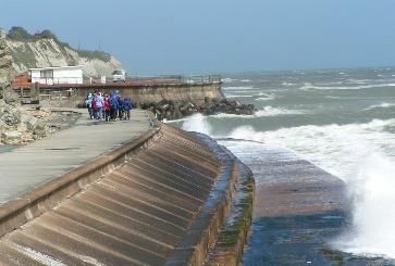
Task 3

  Now you have acquired new knowledge on coastal management and applied to a specific location can
  you retrieve this information ready for your first assessment?

  Lets find out….. Scan the QR code to see if you can retrieve the key facts about Morecambe and
  Heysham. A level Geography you need to be place specific when answering exam questions!

This RGS resource, web link below, is a review of the situation in Venice, considering the factors that make
it vulnerable to coastal flooding – in the past, present and future. You will focus on Section 2 in these
resources (Physical Environment and Flooding), where the threats of flooding from rising sea levels are
highlighted.
TASK 4 Venice
As a comprehensive introduction, first read through/look at the material for all sections/Overview.
In Section 2 Physical Environment and Flooding. Complete the Starter tasks and the 2 Main Activities (not
the Plenary)
https://www.rgs.org/schools/teaching-resources/what-future-for-venice-and-its-lagoon/
Part 2: Strongly recommended content.
Hazards

1)The concept of hazard in a geographical context

2) Plate tectonics

Checklist-
 I can explain the concept of a natural Hazard.
 I am able to explain the difference between a geophysical, atmospheric and
 Hydrological Hazard.
 I understand the terms fatalism, prediction, adjustment/adaptation, mitigation, management,
 risk sharing and how they show different human responses to hazards.
 I can explain the structure of the earth and the characteristic of each of the three interior
 layers.
 I am able to draw annotated diagrams to show the formation of different plate boundaries and
 their associated landforms (Destructive, constructive and conservative plate margins.)
 I can explain how one volcanic or one seismic event will have different impacts:
 primary/secondary, environmental, social, economic, political.
Complete the task below, use some of the suggested reading material and websites to support your
learning.
    1) Name the three types of natural hazards, and give examples of each.
        https://www.youtube.com/watch?v=xYSH-95VlLc
    2) Create a vocabulary sheet / quizlet revision cards to define the key concepts associated with human
        responses to hazards.
    3) Draw an annotated diagram to show the key features of the earth’s structure, create a additional
        diagram to show how convection currents in the earth’s interior cause plates to move.
        https://www.youtube.com/watch?v=AHF_ZVj798g
        https://www.youtube.com/watch?v=ryrXAGY1dmE
    4) Draw annotated diagrams to show the formation of different plate boundaries and their associated
        landforms.
    5) Create a case study profile of either a volcanic or seismic event you have studied at GCSE, use the
        template below to ensure you research it in enough detail. (Suggested examples Mount ST Helens,
        Monserrat, the Japanese Tsunami or Nepal earthquake.)

 Name of Hazard                                        Location- Map
 Tectonic setting- Type of plate boundary (Diagram)
 Development of country
 Magnitude of event
 Impacts on People                                     Impacts on the economy (money)
 EG- Death toll, Number of homes destroyed etc         Cost to economy/ Building damage/Aid needed
 Impacts on the environment (Physical and human) Response- How was this event managed on a
 Loss of habitat/Physical impacts (Flooding, wildfire, local, national or international scale?
 landslide etc)
Suggested support material
https://www.youtube.com/watch?v=2HoTK_Gqi2Q
https://www.youtube.com/watch?v=xjlPmSXj24Y
https://www.tutor2u.net/geography/collections/a-level-notes-physical-hazards
http://www.coolgeography.co.uk/A-level/AQA/Year%2013/A_Level_Revision.htm
Changing Places
Place differs to the abstract notion of space because places
have meaning to people. Space becomes place as we get to
know it better. For many, the most familiar example of place
is their home, where they feel most attached and can be
themselves. As a geographer, you need to look at the
different aspects or multidimensionality of place. In its
simplest way, place is a location with meaning

Checklist-
  I can explain the concept of place and space.
  I am able to explain what places might mean to different people and how this can vary.
  I understand that places can change over time and how places can be connected to other places.
  I can explain and find evidence of multiculturalism and how this might change the character of a
  place.
  I can explain what makes a place great and how this is reflected for my local place.
  My work is A Level Ready: a range of ideas are explained and developed in detail; keywords are
  accurately used throughout; it has clear headings/sub-headings; presentation is something to be
  proud of; my work is at least 7+ pages long (including the 4 ready prepared fieldwork pages).
Doreen Massey (c1994)a geographer engaged with the theorisation of place stated that ‘Places are not
simply bounded locales where people gather…places are made of flows and movements and the myriad of
interlinkages and interdependencies among places. They are simultaneously local and global, their social,
cultural and economic relations stretched out across the globe, shaped by structural processes but retaining
local particularities’.
Yi Fu Tuan (1977) contrasts place with the allied concept of space, stating that ‘place is security’ while ‘space
is freedom’ suggesting that while space is infinite, place is bounded, identifiable and something to which
humans can become emotionally attached.
Complete the task below, use some of the suggested reading material and websites to support your
learning.
6) Special place.
         a. Name a place that is special to you. Where is this special place? What is your special place like?
         b. How would you describe it to someone else? Why is it special/ important to you?
         c. Is this place special to anyone else? Is it special to everyone? Why/not?
         d. How has your place changed over time? Why might this be?
         e. If you had to summarise the character of your place in just 5 words, what would they be?
7) Mini case study of Portsmouth, use this clip https://timeforgeography.co.uk/videos_list/cities/location-
     importance-and-sense-place-uk-cities-portsmouth/
         a. How has the city of Portsmouth changed over time?
         b. How is Portsmouth connected to other places?
         c. What does Portsmouth mean to people (sense of place)? How and why do these views vary?
            Positive views about place - topophilia? Negative views about place- topophobia?
         d. If you had to summarise Portsmouth’s character from the clip or what you know about
            Portsmouth in just 5 words, what would they be?
8) Mini case study of London, use this clip
https://timeforgeography.co.uk/videos_list/cities/multiculturalism-london/:
a. How is London multicultural? What evidence can you find? Quantitative (numerical) or
Qualitative (non-numerical) data?
b. Explain what the term ‘Windrush generation’.
c. How did Brixton become to have a strong West Indian culture? How is this reflected in the
‘changed character’ of Brixton?
d. The West Indian community often suffered ethnic or racial discrimination. Give examples of this.
How did this then develop social cohesion within the community?
e. You are an outsider (most probably unless you are from there) to Brixton, how would you feel
about visiting this place? Do you think it would be a positive experience? Negative? How
comfortable would you feel? Why?
f. Using the ‘Lives on the Line - Tongues’ London map, describe the multicultural nature of London
(note you can click on the stations to find out the language diversity of a place
https://tubecreature.com/#/tongues/current/same/U/940GZZLUBLG/FFTFTF/11/-
0.1000/51.5200/
g. Challenge: select ‘Lives on the line’ on the ‘Metric’ tab. How does life expectancy vary with the
previous ‘Tongues’ map? What patterns can you find?
9) Using the image to the left,
explain why your local place is great (or
what is it lacking if you don’t think it’s
great!). Do you agree with these
categories? Would you like to add
anything else?
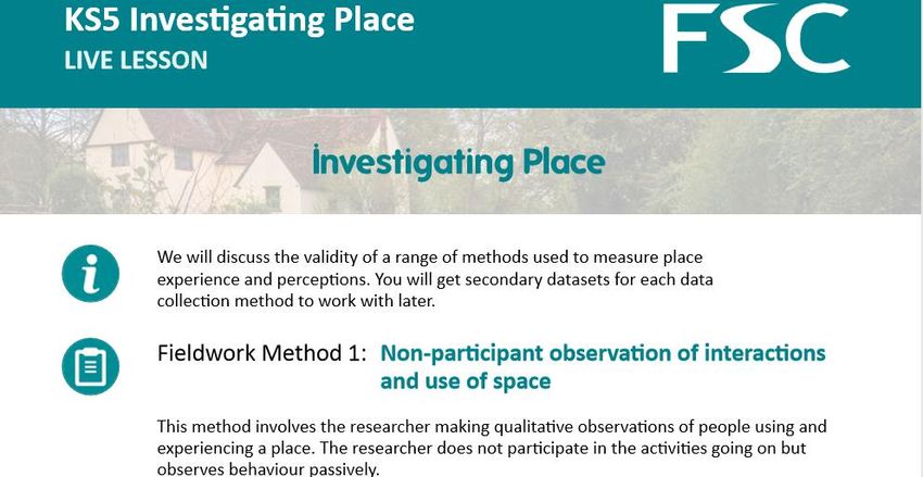
10) FSC Fieldwork LIVE Investigating
Place.
Complete the three fieldwork methods
around your local place, out of your
window or other places using google
streetview. Use the fieldwork material
on the following pages and watch this
45 minute interactive lesson from the
FSC: https://encounteredu.com/live-
lessons/ks4-5-investigating-place-
280420
Suggested support material
https://www.tutor2u.net/geography/reference/introduction-to-concept-of-place
https://www.tutor2u.net/geography/reference/the-concept-of-place
https://www.tutor2u.net/geography/reference/factors-contributing-to-the-character-of-places
https://www.tutor2u.net/geography/reference/insider-outsider-perspectives-on-place
People’s use and         People’s use and experiences of Place               People’s use and experiences of Place
  experiences of
      Place

Appearance, clothing,    Note down anything that might indicate
age, gender, physical    membership of a group such as profession, social
appearance of users      status, socioeconomic class, religion or ethnicity
of area

Physical behaviour       What are people doing? Running, walking? Body
and gestures             language, are they looking around the space or
                         looking down? Behaviour and gestures towards
                         other people and the space

Interactions with each   Are people communicating with each other? Who
other (verbal/ non-      does what, who interacts with whom, who is not
verbal)                  interacting? What is the manner of
                         communication?

Use of space             How are people interacting in the space? What
                         are they doing? Where do they go? Which service
                         do they use? Which routes do they take? Is this a
                         transient place or do people congregate?

People who stand out     Does anyone standout in the environment? How
                         and why? What are their characteristics? What
                         are they doing?
Evaluation of Non-participant observation method: note here any pros or cons we identify
+ -
+ -
What makes this place… Your notes/ evidence…
a special place?
What makes this place special or unique?
Why does it look the way it does?
What local activities/events have shaped its
look?
Why do we like this place?
What can we make more of?
What potential is there to enhance the place?
a well-connected, accessible and welcoming
place?
How accessible is it? What limits connectivity?
How welcoming is it here? Is anything
confusing?
How well does parking work?
How can it be made more welcoming and
accessible?
a safe and pleasant place?
What makes the streets/public space here
safe?
What detracts from the safety and
pleasantness?
(continued)
How safe are the pavements/ road?
How can safety and pleasantness be improved? How do people enjoy nature? What is missing?
(continued) What makes this place… Your notes/ evidence…
a planet-friendly place?
What makes this place planet friendly?
What resources are wasted?
How does movement use resources?
How is waste handled?
How is energy used in buildings?
How adaptable/resilient is this place?
How could this place make better use of
resources?
Evaluation of Non-participant observation method: note here any pros or cons we identify
+ -
+ -Your results Colour Strength
Emotion for ‘Fieldwork Live’ Site
Emotion for another site
Evaluation of Non-participant observation method: note here any pros or cons we identify
+ -
+ -
If we were doing this in the field, what sampling strategy might be appropriate? Justify your answer.
Now try submitting some further observations for the place you are working from now. We will use Survey
123 to do this, follow this link https://bit.ly/fieldworklivePlaceData . This will help us capture an extensive
big-dataset for how people feel about their place right now.
If we were doing this in the field, what sampling strategy might be appropriate? Justify your answer.A level Summer Independent Learning - Statistics
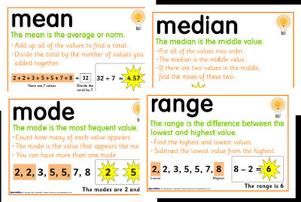
I can accurately use measures of central tendency – including mean, median and mode
I am to identify patterns, trends and anomalies.
I am able to manipulate data from sources.
I can use non parametric measures of statistical dependence – Spearman’s Rank Correlation
Coefficient.
As part of your A level you will be expected to undertake a variety of mathematical skills that will help you
manipulate data in exam questions, alongside your exams you will be expected to undertake geographical
fieldwork which is worth 20% where you will have the opportunity to analyse data.
What statistics do we need?
Mean = average Hot Hot…. The number of chillies represents the level
Median = middle of difficulty.
Mode = most common
Range = difference between highest and lowest
Interquartile range = UQ-LQ
1
..
2
.
.3 . 4.
5
.
Below is secondary data regarding infiltration rates, in 3 distinctive regions of a river course.
Now complete this for all data sets:
    1. Mean = average
    2. Median = middle
    3. Mode = most common
    4. Range = difference between highest and lowest
    5. Interquartile range = UQ-LQ

6.
You can also read