GLENBROOKLIFE - Glenbrook Homeowners Association
←
→
Page content transcription
If your browser does not render page correctly, please read the page content below
GLENBROOKLIFE
Nature’s paradise on your doorstep.                            WINTER/SPRING 2019 NEWSLETTER

                                                                                  in this issue
                                                                                  Letters to the Members.............. 1-4

LETTER TO THE MEMBERS FROM THE                                                    Ascent to Capt. Pomin Rock......4-5

GHOA BOARD OF DIRECTORS                                                           Meadows/Forest Health.............6-7
                                                                                   & Fire Safety Update
The following is a summary of our 2018 accomplishments and the major
                                                                                  Slaughterhouse Meadow........... 8-9
GHOA activities which are currently underway at Glenbrook.
                                                                                   Restoration Project
4FISCAL YEAR 2018 GHOA completed Fiscal Year 2018 with a cash                     Sierra Storm King Returns......10-11
surplus of $32,910 which continues GHOA’s excellent financial health. At
                                                                                  NASA Sierra Nevada Snowpack...11
the start of Fiscal Year 2019, the Association had $2,177,887 in its Reserve
Fund for use on future capital assets’ upgrades and maintenance.                  Glenbrook’s Big Snow..................12
                                                                                  Birth & Fate of Natl Treasure.........13
4WINTER/SNOW REMOVAL The                     GHOA Board awarded the
2018-2019 snow removal contract to Nevada Environmental Consulting                NV Boater Req’d Equipment........14
(NVENV). The objective of the snow removal program is to have GHOA                Near Shore Monitoring Update.....15
owned roads open and passable at all times during winter. Residents
know only too well how the snow stacked up in February with back to               Lake Tahoe Interesting Facts........16
back to back storms that really put the snow removal crews to the test.           Activities Around Lake Tahoe.......17
After the first multi-day storm NVENV evaluated their shortfalls, added
equipment, and revised plowing schedules to ensure that the GHOA                  Glenbrook Historical.....................17
roads remained clear at all times. These improvements worked well and              Society Presents
our roads remained clear and safe despite one of the heaviest snow                Brandi Family Survives............18-19
years in a decade.                                                                 Winter of ‘52

4LANDSCAPE CONTRACT                     For 2018, GHOA awarded the                Glenbrook Memorials................... 20
landscape contract to Incline Property Management (IPM), our community            Glenbrook Crossword...................21
management contractor. IPM is celebrating its 38th year serving the Reno
Tahoe Region’s residential homeowner associations (HOAs) and regularly            Reverse 911................................... 22
provides landscape maintenance to their HOA customers. We all saw                 Glenbrook Area Restaurants........23
a significant improvement in our GHOA landscape and maintenance
during 2018 and we expect more improvements during 2019.

4UPGRADE GHOA’S IRRIGATION SYSTEM FOR SMART CONTROLLERS This spring
GHOA will go out for bid for the installation of “smart controllers” to allow us to turn off sprinkler zones upon
detecting a leak, following a rain storm and/or when the surrounding soil is moist. Matt Setty from NVENV is
assisting GHOA with design of the specifications, soliciting bids and the preparatory work needed to intertie
separate sections of the irrigation system to allow for remote sensing and control from the GHOA office. We
hope that this project will result in significant water savings for GHOA during the last half of 2019 and thereafter.
4YERINGTON/DIRIGO TO GLENBROOK                                 As part of these plans, Matt has requested a permit
 PATHWAY UPGRADE For several years,                            for vegetation removal, reversal of the trail erosion,
GHOA, the Glenbrook Club, and Mr. Kingman have                 reversal of stream course ponding, and improvement
discussed improvements and realignment of the golf             of stability issues.
cart pathway form Dirigo Court to the Glenbrook
Clubhouse. This shared project is now in the detailed          4FIRE SAFETY UPDATE Over the past few
planning stages with the hope of obtaining TRPA                months members of both GHOA’s Meadows/Forest
approval during 2019, reconstruction thereafter, and an        Health & Fire Safety Committee, as well as the GHOA
eventual deeded right-of-way to and from Yerington             Board have been reviewing a unique fire prevention
Park and the Glenbrook Club.                                   plan for Glenbrook which was presented to us by Matt
                                                               Setty (NVENV) in conjunction with Conrad Wright,
4SLAUGHTERHOUSE CANYON                                         President of Alchemy Aerial. During March, the
 STREAM RESTORATION As many of you have                        proposal was unanimously approved and funded by
observed, much work was completed during 2018 to               the GHOA Board.
restore Slaughterhouse Creek to its natural channel,
to remove mosquito breeding grounds, to improve                The intent of this plan is to significantly reduce fire risk
access for mosquito vector control, and to reduce fire         and provide mitigation within the entire Glenbrook
risk in China Garden and Land’s End.                           community. Matt’s and Conrad’s firms will team up
                                                               to collect high quality data, from both aerial and on-
The most significant 2018 accomplishment was the               the-ground surveillance to identify the highest fire-risk
near-complete clearing and channel restoration on              areas. With this data, they will suggest fire management
the west side of Land’s End road. The willows and              remedies to Tahoe-Douglas Fire District (TDFD) to
other swampy growth were cleared, stacked, dried,              mitigate fire risks.
controlled-burned by TDFD, and the Slaughterhouse
Creek channels were restored. Seeding (with an indig-          TDFD, as well as at the Nevada State Fire authorities
enous wild seed mix) will take place this spring. Now,         strongly support this plan to provide high-resolution
we can see the lake from lower Land’s End Road!                data for fire prevention within Glenbrook and for
                                                               future state and federal grants for fire prevention and
4MOSQUITO ABATEMENT                Douglas County              Glenbrook “halo” clearing.
Mosquito Abatement sprayed during the 2018 spring/
summer seasons to control mosquito larvae in                   4GLENBROOK EVACUATION
Slaughterhouse Canyon (and other potential mosquito             PROCEDURE TRAINING On                  August 30,
breeding grounds throughout Glenbrook). This was               2018 the Tahoe Douglas County Fire Department
augmented by NVENV’s purchase and installation of              in conjunction with GHOA and the Glenbrook
150 mosquito “dunks” (for vector control) which were           Community conducted Glenbrook Evacuation
placed in areas of stagnant water not accessible to            Plan Training at the Glenbrook Clubhouse. There
Douglas County Mosquito abatement. GHOA entered                was a great turn out, the information was greatly
into a contract with Douglas County Mosquito                   appreciated and we look forward to repeating this
Abatement to sustain the mosquito abatement within             training during 2019 (scheduled for August).
Glenbrook at a cost of $15,000 for the 2018 spring/
summer seasons.                                                4NV ENERGY During 2017 (due to numerous
                                                               power outages within Glenbrook), NV Energy
4LAKE MILL MEADOW                   Matt Setty is also         initiated evaluation of a construction plan to rebuild
helping GHOA to remove the small pond near Lake                the 624-power transmission line from Carson City
Mill Road and to create a plan for the use of all GHOA         to Glenbrook by offsetting the new construction
meadows as fire-safe zones within Glenbrook in the             approximately 20 feet to the north of the existing
event of a major community fire. These will include:           line. After construction of the new line, the distribu-
                                                               tion circuits would be transferred to the new poles
1.   Revision and update of the fire-fuel management           and the existing line would be removed. This alterna-
     areas to reflect the meadow areas that are being          tive construction method would facilitate helicopter
     encroached upon by aspens/willows and other               construction techniques and maintain an acceptable
     vegetation. This will then place the Lake Mill area       level of service to all customers during construc-
     (and other meadows) into the defensible space             tion. During analysis of this plan, several issues were
     management areas with fire breaks around each             raised by the USFS which requires a greater level of
     fire safe zone; and,                                      environmental review to analyze and authorize the
                                                               expanded right-of-way area, removal of approximate-
2. Development of a design to address trail erosion            ly 187 trees to expand the right-of-way and increased
   along the Lake Mill beach access path.                      impacts to private lands for both the new easement

                                                           2
area and the tree removal. NV Energy determined
that these issues will significantly delay the project
schedule and increase the project costs and risks.

NV Energy has reverted back to its original plan
to rebuild the entire 624 line in place and mitigate
the unacceptable customer outage impacts on the
distribution circuits by deploying temporary generators
during construction. Below are the schedule dates for
the updated project plan:

Submit App to the U.S. Forest Service............. September 2015
Complete environmental permits.................................... Mid-2019
Vegetation management........................................................Fall 2019
Line construction..........................................Fall 2020 and Fall 2021
Project Completion.....................................................................Fall 2021

Construction activities are restricted to the fall months
due to environmental protection measures, to
mitigate impacts on sensitive species and their habitat,                                               LETTER TO THE MEMBERS FROM
their customer service requirements, and the winter                                                    THE GCTA BOARD OF DIRECTORS
weather restricted conditions.
                                                                                                       Each winter at Glenbrook seems to present a
4FAIR SHARE          The Association continues to                                                      different weather pattern compared to its immediate
explore an equitable resolution for the Fair Share of                                                  predecessor. As we write this letter in late February,
common community expenses by all Glenbrook                                                             Glenbrook is being inundated with an unrelenting
property owners for GHOA provided assets. These                                                        storm pattern of snowfall and intermittent rain with
assets include roads, drainage systems, bridges,                                                       scarcely even a short reemergence of that golden
front gate operations, the pier, beaches, the buoy                                                     ball in the sky also known as the SUN. However, the
shuttle service, parks, community fire “halo” and                                                      holiday season was more temperate and roads and
fire prevention, and other amenities operated and                                                      access were clear allowing for member access to all
maintained at the expense of GHOA’s members. To                                                        GCTA units. Nevertheless, those of us who were here
this end, the GHOA Board is in contact with GPOA                                                       for Super Bowl Sunday will remember the incredible
representatives and continues to review alternatives                                                   accompanying snowfall.
to garner equitable participation by all Glenbrook
property owners in the common expenses attributable                                                    GCTA received an unqualified audit for FY 2018 (ending
to the maintenance and operation of these assets.                                                      Sept 30, 2018) with slight overage of revenue in the
                                                                                                       Cottages and a slight negative in the Townhomes.
                                      Sincerely,                                                       Both enjoy strong cash operating balances and are
                                                                                                       on budget for the first four months of FY 2019.
     The GHOA Board of Directors
                                                                                                       Each year your Board adopts a set of goals to
                                                                                                       measure GCTA’s performance and to set priorities
            DICK STUART PRESIDENT                                                                      for ensuing 12 months. Meeting the FY budget, as
                                                                                                       verified by the annual audit, is the key to continuing
      PETE JENSEN VICE PRESIDENT                                                                       financial stability. Building required reserves under
                                                                                                       the guidance of the Reserve Specialist, is a critical
         NANCY NOLAN TREASURER                                                                         ingredient to every budget and likely to be the
                                                                                                       Association’s most challenging budgetary task for
         ROGER LA VOIE SECRETARY                                                                       the next several years.

                   JACK DIEPENBROCK                                                                    As previously reported, the roofs on our 68 member
                                                                                                       Townhome units are approaching the later stages
                                                                                                       of their service lives and will require replacement
                             TOM TORNGA                                                                in phases. The Board has appointed an advisory
                                                                                                       committee to study and advise on this process and
                        JONATHAN FORE                                                                  retained a specialized consulting firm to inspect
                                                                                                       all 68 units and provide recommendations on
                                                                                                       immediate repairs, an annual maintenance program

                                                                                                   3
and a projected timetable prioritizing individual roof
replacement. This data is the basis for determining
the needed level of reserves whose funding is
reflected in the annual GCTA assessments as a key
budget component. Townhome members have
seen an increase of $100 per quarter in FY 2019. It is
likely that there will be additional annual increases
in FY 2020 and going forward until the re-roofing is
completed in the next two to eight years.
There also appear to be inequities in the projected
individual unit roof replacement costs. This situation
is under further analysis. Correction may require a
revision to GCTA’s Governing documents.

                                                          FALL ASCENT TO CAPTAIN
                                                          POMIN ROCK BY LARRY TIETIG3
                                                          Fall in Glenbrook is a special time. The crowds
The danger of fire is unrelenting and therefore
maintaining defensible space throughout our               have thinned, the weather is comfortable
community is critical to minimizing risk. China           with warm days, cool nights and the fall
Gardens has the most dense vegetation and                 sunlight seems softer especially in the late
continues to be the focus of this initiative. Tahoe       afternoon. On this day I was excited to get
Fire Service will continue to partner with us to assist   out and explore, so I decided to hike up to
in removing dead and diseased trees and brush;            Captain Pomin rock which is just over the
however the basic responsibility rests with our
individual member homeowners to police their home         ridge behind Glenbrook.
sites. GCTA needs your continuing engagement and
                                                          I had read about Earnest John Pomin, but
support to maintain defensible space.
                                                          had not learned about the special honor he
Your Board believes we are all very fortunate to have     had received from the Bliss family upon his
such a gifted community manager as Ms. Jenny Clark        tragic death – more on this later.
and her dedicated staff members. Continually focused
on meeting the needs and expectations of our mem-         None of the maps I had investigated showed
bers, they reflect that special attitude and “Can Do”     the location of the rock until I looked at a
spirit that is baked in to the DNA of Glenbrook.
                                                          forest service map trying to locate the King’s
              Happy Spring & Summer!                      canyon trail. This trail was the main trail to
                                                          Spooner summit and Lake Tahoe before
   The GCTA Board of Directors                            the silver discovery in Virginia City. On that
                                                          map they showed Captain Pomin rock, and I
 CLAUDE HUTCHISON PRESIDENT                               made the decision to hike there at that time.
 NANCY NOLAN VICE PRESIDENT                               I had climbed to the ridge top behind
                                                          Glenbrook several times, but each time I
  RANDALL BOLTEN TREASURER                                was unaware of the Pomin rock. Well, this
  SUSAN COUNTNER SECRETARY                                was the day that I was going to locate and
                                                          photograph the rock. I started from my house
        ROSS BARNETT                                      with water, and a few snacks, and walked to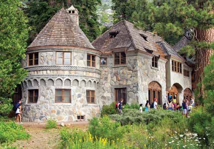
needed conscripts to protect their borders.
                                                         The boys traveled to New York and then around
                                                         Cape Horn, the southern tip of South America,
                                                         to San Francisco. In 1868 they arrived at Lake
                                                         Ta Ho – the name at the time - in what is now
                                                         Tahoe City. One brother William opened Tahoe
                                                         House Hotel there, and was soon partnered
                                                         with his bother Fred. Earnest and Joe both
                                                         became steamship captains.
                                                         Joe worked for “Lucky” Baldwin and piloted
                                                         both the “Tallac” and the “Maime” while Earnest
                                                         worked for the Bliss family enterprises and
                                                         piloted the “Meteor” and the “SS Tahoe”. Both
                                                         Bliss vessels were launched at Glenbrook, the
                                                         “Meteor” in 1876 and the “SS Tahoe” in 1896.
                                                         Earnest commanded the “Meteor” until
                                                         the “Queen of the lake” was launched, and
the homeowners office, and followed the dirt             commanded that vessel until his untimely
road up to the water tank. From there the hiking         accidental death in 1919. He was inspecting
became more difficult. It was a steep ascent             the Tahoe for its normal mail run on December
– going from 6500 to over 7500’ – that was               10, when he apparently slipped on some ice
covered with layers of slippery pine needles.            on the dock in Tahoe City, and hit his head
Since there was no trail I had to switchback my          rendering him unconscious and fell into the
way up the slope taking breaks to catch my               lake and drowned.
breath every few minutes.
                                                         As the crew arrived they were surprised that
I must caution the novice hiker that this is an          Captain Pomin was not onboard. Soon they
extremely strenuous hike. It is as steep as the          found his body submerged next to the dock.
ascent to Shakespeare rock. Eventually, with             This tragedy had ended an era of service to
extreme effort, I was on the ridge top with a            the Bliss family by Earnest John Pomin. They
spectacular view of the lake. I was not sure             then rewarded his loyalty and dutiful service
which way to proceed so I wandered around                by naming the cluster of rocks on the ridge
for 30 minutes until I located the rock.                 behind Glenbrook in his honor. Author’s note;
                                                         in the process of my research for this article, I
The sun just happened to be at the proper                was able to find an easier route to this “rock”.
angle, and the rock was bathed in its golden             If you search using “Captain Pomin Rock” you
light. I took several pictures, to record the            will locate a website that takes you by way of
moment, and as I circumnavigated the rock I              Highway 28 to the outcropping. The view is
realized that I had in fact been to this spot on a       certainly worth the effort.
previous hike without knowing its significance
at the time. Knowing now that it was named
for the longest serving steamship Captain, 43
                                                            Enjoy, and keep exploring!
years, on Lake Tahoe added to its presence.
Who was Earnest John Pomin you ask? He was
born in the Alsace Lorraine area of Germany
in 1847-48 and left there with three of his
four brothers in 1866. Prussia had recently
consolidated the many German states and they

                                                     5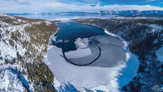
UPDATE ON THE MEADOWS / FOREST HEALTH & FIRE SAFETY
COMMITTEE ACTIVITES BY ROGER LA VOIE 3
Committee: Larry Tietig, Peyton Bruns, Dr. John
Hoeffer, Anton Walden, Phil Atkins-Pattenson,
Jonathan Fore, and Roger La Voie
First, our sincere thanks to Dr. Sonia Rupp who recently
resigned, having provided us with many years of dedicat-
ed, valuable work. Fortunately, two new members have
been added. One is Phil Atkins-Pattenson, having retired
from his law practice in San Francisco and now living
full-time at Glenbrook. Noteworthy to us, his practice in-
cluded business litigation regarding land use and envi-
ronmental issues. Also, we are pleased to have Jonathan
Fore, a recently elected GHOA Board member. Together
they have much to offer. We also feel this Committee’s
responsibilities encompass such an extensive scope of
work, particularly with fire protection having become
such an increasingly urgent concern… that an expansion
in membership is warranted.
                                                                 2017 was a year devoted to studying the causes that led
                                                                 to the flooding of the wetland along with the extreme
                                                                 overgrowth of vegetation. Some combination of beaver
                                                                 activity, poorly engineered culverts, and a diversion
                                                                 channel directing much of North Canyon Creek’s water
                                                                 flow away from its primary stream-bed, led to an unhealthy
                                                                 and non-functional meadow. Later that year Tahoe Douglas
                                                                 Fire District (TDF) told us that the western portion of the
                                                                 meadow had become an extreme fire danger. Should a
                                                                 fire ignite near the homes around Lands End, both firemen
                                                                 and their equipment could become trapped and at risk.
                                                                 So now, besides the mosquito issue, we had a second
                                                                 compelling reason to remedy the situation.

                                                                 We wish to emphasize the transformation to date is truly
                                                                 ground-breaking in nature, and hopefully you will get that
Slaughterhouse Meadow                                            sense from Matt’s article. In addition here are a few bullet
                                                                 points to consider:
Many residents have not yet had the opportunity to
view the extreme makeover that has occurred since                • Last fall fire chiefs from districts throughout the Tahoe Ba-
summer between Lands End Road and China Beach. On                  sin met onsite with TDF to review the planned undertak-
the following pages, Matt Setty, GHOA’s consultant and             ing. Their interest focused on a unique type of prescribed
principal of Nevada Environmental Consulting (NVENV),              burn for fuel reduction in wetland or riparian areas. It cen-
has penned an article detailing the scope of work which            tered around the use of large fuel piles of vegetation, as
transpired over the fall and winter. Hopefully readers             is detailed in Matt’s article which he describes as “pizza
will appreciate the sophisticated technical and scientific         ovens”. Several fire chiefs were so impressed, they have
work that has gone into this project. While there is much          recommended that TDF submit this project for the “Best
more to come, we believe we are off to a successful start,         of the Basin” award. This involves a TRPA led multi-agen-
as it is no longer a discussion item or concept. When              cy review panel of Tahoe area restoration projects.
Douglas County Mosquito Abatement informed GHOA
in 2016, that due to the extreme vegetation overgrowth           • TDF and NVENV are developing an article for submittal
they could no longer access mosquito breeding habitats             to Fire Science Magazine (a national publication), as well
and protect against the threat of West Nile Virus; that            as similar articles for other range and forest science jour-
provided the initial catalyst for embarking on meadow              nals. This is due to both the uniqueness of the approach
restoration and the hiring of NVENV.                               to burning in riparian zones, as well as for the methods

                                                             6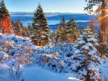
used to evaluate the science and methodology. Through          ty areas for fuel reduction on GHOA owned land within
 their use of drones and thermal cameras they measured          the Halo region. Work will begin when allowed by TRPA
 the temperatures within the piles at an average of 1360        statute, as there is currently a moratorium. Should it be-
 F, 400 degrees more than they expected. This enormous          come cold enough along with low snow cover over the
 heat resulted in a quick burn and a significant reduction      next couple of months, some may be done soon. We will
 in smoke.                                                      focus on getting the most done for the lowest cost. TDF
                                                                crews will work in the more difficult areas (steep slopes,
• Concern was understandably expressed by many resi-            big timber etc.).
  dents over the risk of a prescribed burn, both from the
  standpoint of a fire getting out of control as well as po-   • We are meeting with with TDF in early March to discuss
  tential smoke and air quality issues. Several suggested        various Glenbrook fire issues.
  hauling out the debris. But chipping alone could have
  taken up to a month and also led to air quality problems.    • It has been 10 years since the 50+ page Glenbrook Fire
  Then over 100 truckloads would have been required to           Safety Manual was distributed to all homeowners. Peyton
  drive through Glenbrook causing likely road damage.            Bruns has been spearheading the effort to re-write this
  The prescribed burn alternative cost our homeowners            and bring it up-to-date; then Ideally distribute it to all res-
  nothing, entirely covered by grant funding.                    idents this summer.

• Such grant funding has played a                                                       • NVENV is presently working on
  major part in this project. TDF                                                       a proposal to GHOA for a high-
  work of approximately $43,000                                                         tech driven, comprehensive plan
  was entirely funded; as was resto-                                                    for fuels management reduction
  ration, environmental protection,                                                     around Glenbrook. While in the
  and re-seeding of $23,000.                                                            early stages, hopefully we will
                                                                                        have additional information in the
• What’s next for 2019? Regarding                                                       months ahead.
  the wetlands above Lands End
  Road, NVENV has contacted
  the US Corps of Engineers to
  obtain a Letter of Permission for
  performing similar work to last
  year (i.e. vegetation removal, a
  burn, re-seeding, etc.). Altogether
  we would be restoring two to
  three acres of willow removal
  to address further the mosquito
  and hydrology issues. Ideally,
  it would also include a beaver
  pond solution, which Matt’s
  team is currently designing and
  hoping to install adjacent to the
  southeast side of the road. This
  was discussed in the December
  2017 Master Plan. Regarding the overall project cost,
  NVENV is presently working with John Pickett at TDF
  on a plan for additional grant funding. The anticipated
  work window should begin in late summer when stream
  flows are reduced.

Fire Safety
Given the disastrous California wildfires in the past 16
months this is now our highest priority. We hope to have
some important information coming throughout this year.
Here are a few early comments:

• Matt Setty has been working with TDF to secure a 100
  acre mastication contract that will address high priori-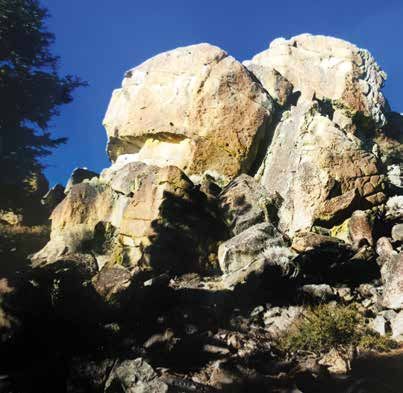
SLAUGHTERHOUSE MEADOW PRESCRIBED BURN AND
WETLAND RESTORATION PROJECT
Throughout the summer and fall of 2018 GHOA
partnered with the Tahoe Douglas Fire Protection
District to conduct a prescribed burn and wet-
land restoration project in the lower portions of
Slaughterhouse Meadow. Work started in late-
July with TDF crews and Nevada Environmental
Consulting (NVENV) restoration crews cutting
and stacking the over-mature willow and alder
trees located between Lands’ End Road and Lake
Tahoe. This work continued through the end of
September. The objective was to cut and stack
the decedent vegetation, so the live trees had a
chance to dry out in preparation of pile burning                                    NVENV preparing for the prescribed burn
in October and November.                                                   by pile stacking vegetation. Photo Credit: NVENV

                                                                These piles were stacked around large diameter
                                                                material with finer material and soil-wood debris
                                                                placed around the edges and on top. This style
                                                                of pile allows for greater air space inside the
                                                                pile resulting in higher temperatures and more
                                                                complete combustion of the piles. A total of
                                                                18 “Pizza Oven” style piles and windrows were
                                                                constructed, and the majority have been burned.
                                                                Project funding: The work done by the TDF
                                                                crews and pile stacking performed by NVENV
                                                                was funded through U.S. Forest Service and
                                                                Nevada Division of Forestry grants. The stream
                                                                restoration work and water quality, environment
                                                                protection, and Best Management Practices,
                                                                and re-vegetation/reseeding was funded
 Tahoe Douglas Fire Crew on 11/30/18. Photo Credit: NVENV       directly by GHOA.
This prescribed burn program achieved several                   The prescribed pile burning was used as
key objectives of the Slaughterhouse Meadows                    learning opportunity for TDF and NVENV to
wetland restoration project. The main objectives                advance the understanding prescribed fire in
included: 1) reduction of fire fuels and improved               riparian zones. The high moisture conditions
safe access along Lands’ End Road, 2) restoration               make these types of burns act differently than
of the low-flow channels to convey North Canyon                 typical small pile burn done in the upland forest.
Creek through the low gradient meadow, thereby                  The learning objectives included: 1) determine
reducing the saturated conditions that have                     the influence of pile structure on combustion,
contributed to mosquito problems, and improve                   2) how best to reduce impacts from smoke
biodiversity lost to the degraded environment                   through management of burn temperatures,
caused by the thick willow canopy.                              and 3) evaluate the wetland response to high
                                                                temperature pile burns with regard to carbon
In a first of it kind prescribed burn plan, TDF and             conversion and available to new plant growth
NVENV designed and constructed large piles of                   (soil chemistry).
the riparian vegetation.

                                                            8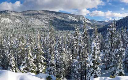
of Environmental Prot-
                                                                                                ection (NDEP) partici-
                                                                                                pated in the project
                                                                                                by providing portable
                                                                                                air quality monitoring
                                                                                                stations around the
                                                                                                community. This data
                                                                                                shows the very limited
                                                                                                impact of the smoke
                                                                                                during these large pile
                                                                                                burns. The generation of
                                                                                                smoke is directly related
Burn pile reaching maximum temperature. Photo Credit: NVENV        Photo Credit: P. Tsukamoto   to the pile temperatures.

These areas of interest were assessed using                         • Upcoming revegetation (spring planting)
UAV (drones) equipped with visual and thermal                         will be monitored to assess the influence
sensors. NVENV and its business partner Alchemy                       of the carbon released into the soils on
Aerial imaged the piles throughout the burn                           regrowth of native wetland vegetation. It
process to determine the relationship between                         is anticipated that the reintroduction of
smoke production and pile temperature. The                            carbon released from the pile burns will
thermal imagery allows for real-time monitoring of                    positively impact the soils chemistry of
the burn piles and could be used to track the rate                    the wetland and restore the biodiversity
and conditions of the internal areas of the piles.                    and water quality protection properties
                                                                      provided by the wetlands.
What Was Learned – The project team is
currently evaluating the data generated during                    The next steps on this project will be to
the October and November burns, but in                            clean up remnant chard vegetation, replant
summary the following information was learned                     the meadow with native seed mix, address
and will be applied to future fuels management                    several areas along the creek near the lake to
projects in riparian zones.                                       facilitate lowering the water table to reduce
                                                                  mosquito habitat, and finish several smaller
  • Pile structure has an important impact on                     pile burns. Currently the TRPA regulations limit
    the peak temperature and completeness                         the access due to seasons regulation. Once
    of combustion of the piles. Large piles                       access is allowed, final work will commence. It
    constructed with adequate internal air-                       is anticipated that the meadow will be green
    space can maintain temperatures near                          by late spring, and the remnants of the burn
    1,360°F long enough to completely consume                     will be undetectable by later summer.
    large diameter riparian vegetation. This
    is achieved through limiting the volume                                       BY MATT SETTY 3
    of air exchanged around the
    perimeter of the burn pile.        Lower Slaughterhouse Meadow Restoration Simulation. Photo Credit: NVENV

  • Pile orientation with respect
    to prevailing wind direction
    during the burn can limit
    the partial burning and pre-
    ignition of piles to limit smoke
    generation during the burn.
    This results in less of a comm-
    unity impact from smoke and
    air quality. The Nevada Division

                                                              9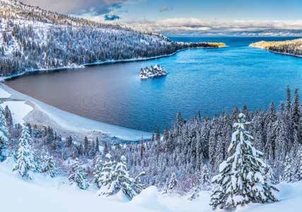
For early American settlers struggling with
ox-drawn farm wagons, crossing the range
ranked as the most difficult obstacle in their
2,000-mile trek to the Pacific. Fantastic tales
of an endless summer paradise in coast-
al California were tempered by the fear of
mind-boggling snowfall in the mountains.
                    — Mark McLaughlin, author of
                  Reign of the Sierra Storm King –
                A Weather History of Donner Pass

THE SIERRA STORM KING HAS RETURNED BY SHARON BOWMAN 3

The 2019 President’s Day Weekend will probably be            down and across the Pacific Northwest. “When the Sierra
remembered by the Lake Tahoe basin’s long-time               Storm King asserts his meteorological power over this
locals as the weekend the “Sierra Storm King” made           rocky domain, travelers beware,” warns McLaughlin.
his appearance again. The moniker hails from the 1800s
when the Central Pacific Railroad began recording yearly     In 1952, year-round residents of the Lake Tahoe basin
precipitation and snowfall amounts on Donner Pass.           used tee shirts to immortalize a more recent catastrophic
                                                             appearance by the Storm King. The tee shirts read “I
Originally called Truckee Pass, the formidable northern      Survived the Winter of ’52.” Winter began with heavy
gateway through the Sierra Nevada mountains was              snowstorms in October 1951 and, by January 1st 1952,
renamed after the unfortunate Donner Party – a group         twenty-three feet of snow had closed and buried Donner
of California-bound emigrants – became trapped for           Pass. According to McLaughlin, “Locals and travelers
months in the deep snows by a series of ten major winter     were overwhelmed, but the Storm King was just getting
storms between 1846 - 1847. Because of the severity of       started.” In mid-January, another huge blizzard slammed
the storms, the story of the Donner Party is now etched      into the mountains and raged for seven days, dumping
in the history of Lake Tahoe, and the “Sierra Storm King”    another thirteen feet of new snow on Donner Pass and
label was born.                                              trapping a Southern Pacific Railroad train with 226
                                                             passengers on board. Although the passengers were
Mark McLaughlin is a nationally published author and         eventually rescued, two of the volunteer rescue team died
Tahoe historian who has written extensively about the        in the adverse conditions. Major snowstorms continued
Sierra Nevada and its geology, climatology, and human        off and on until the end of March that year and Emerald
history. According to Mr. McLaughlin, The Storm King’s       Bay froze over for the fourth time in recorded history.
lair is in the Gulf of Alaska. For the last 150 years, as
evidenced by precipitation records, most of the coldest      The Storm King struck again in the winter of 1981 - 1982,
and life-threatening storms in and around the Lake Tahoe     when heavy snows caused some of the most extreme
basin have first formed in Alaska, before making their way   avalanche conditions in Tahoe’s history. That spring, a

                                                         10
gargantuan snow slide peeled off a northern ridge of
Alpine Meadows Ski Resort on Lake Tahoe’s west shore,
burying the resort’s buildings and costing the lives of
seven people. “That event was far and away the most
destructive, deadly event in ski area history in North
America,” lamented Larry Heywood, who was Alpine
Meadow’s assistant ski patrol director at the time. On
a minor note, Lake Tahoe Unified School District closed
its doors for two weeks during that winter due to the
storms and power outages, which meant that students
had to remain in school until June 30th to make up the
lost school time.
NASA RELEASES INCREDIBLE
Fast-forward to the winter of 2016-2017. After a dozen
years of severe drought in California and the Sierra SATELLITE LOOK AT SIERRA
Nevada, the Tahoe basin experienced another of the NEVADA SNOWPACK
Storm King’s epic winters. This time around, though,
the King traded his Alaska lair for a subtropical habitat. Satellite images released by NASA this week put the
Ten “atmospheric rivers” of moisture flowed up from the massive amount of snow in California’s mountains
southern Pacific Ocean that winter, drenching California into perspective.
in rain, covering the Lake Tahoe basin in snow, and raising
the lake to its natural rim level – a height not seen in over Winter storms this year have produced incredible
eleven years. Because many of the basin’s residents had levels of snow in the Sierra Nevada, and more rainfall
never experienced a winter like this one, they called it is expected.
“Snowmageddon” and assumed it was an anomaly, not
to be repeated. A photo from NASA showed the mountain region in
February of 2018 and February this year. The side-by-
That brings us to the winter of 2018 - 2019 and the Storm side snapshot shows extensive snow this year cover-
King has now roared back with a series of storms that ing the western slopes of the region:
have, to date, dropped more than six feet of snow at
lake level and at least twice that at the higher elevations. “The Sierra Nevada is really living up to its name
Mr. McLaughlin was right when he warned travelers to ‘snowy mountain range’ this year. With snow reports
beware: the winter isn’t over yet and the Storm King coming in feet & snow storms still moving in, it’s now
rules. McLaughlin’s final advice for travelers venturing into home to the snowiest ski resort in the U.S.,” NASA
the Tahoe basin and mountains this winter? “Stay smart or tweeted.
stay home!”
Much of that snow can be experience in areas close
to Southern California like Mammoth Mountain,
where NASA says more than 37 feet of snow have
fallen since the beginning of winter, leading to it be-
coming the “snowiest ski resort” currently in the U.S.
According to the California Department of Water
Resources, the mountain range has received the
snow water equivalent of 130 percent of normal as
of Feb. 11. In just Nov. 2018, the range was 44 per-
cent of normal.
And it could mean good news going into 2019 and
For more about Tahoe historian, best-selling author, dealing with drier months down the road.
and professional speaker Mark McLaughlin, log onto his
website at http://www.thestormking.com or email him “Spring and summer melt from the Sierra Nevada
at mark@thestormking.com. You can find his books in plays a crucial role in recharging California’s reser-
local bookstores in and around the Lake Tahoe basin. Mr. voirs. Though conditions could change, California
McLaughlin has seven books and more than 750 articles drought watchers are cautiously optimistic that the
in print and is always delighted to bring his entertaining boost to the snowpack will insulate the state from
and informative presentations to any local group that is drought this summer,” NASA’s Earth Observatory
interested in Lake Tahoe history. blog reports.GLENBROOKS BIG SNOW
Snowfall has more than made up from a big
deficit in December with many mountain areas
now running close to or above average for the
season with more big winter storms to go. The
depth of the snow cover over the high country
ranges from 6-12 feet as of early February. Within
that snow cover, 1-2 feet of water is locked up.
This winter’s snowpack over the high country
should go a long way for water supply during the
upcoming dry season. The deep snow over the
Sierra Nevada and Carson Range surrounding Glenbrook. It should be a great summer for boat-
Lake Tahoe slowly melts during the spring and ing!. On February 1 Lake Tahoe was 4.07 feet
summer, which helps to keep streams running above its natural rim (now higher at or above
and the lake full. 4.5 feet), holding 67% of its maximum usable ca-
pacity, which is 179% of average for February 1.
One winter storm in January/February dumped
over 3 feet of snow at some Lake Tahoe ski The Natural Resource Conservation Service
resorts in 24 hours. Kirkwood Mountain Resort (NRCS) Snow Survey Program provides mountain
reported 31 inches in 24 hours and a storm total snowpack data and streamflow forecasts for
of 35 inches. Sierra-at-Tahoe reported a 24-hour the western United States. Applications of
total of 23 inches at its base and 37 inches at its snow survey products include water supply
summit, and a storm total of 24 inches at its base management, flood control, climate modeling,
and 39 inches at its summit. Heavenly Mountain recreation, and conservation planning. You can
Resort reported 42 inches in 24 hours and a monitor the snowpack levels on their website:
storm total of 43 inches. Another subsequent http://bit.ly/2TwuYUg
storm in February dumped over 7 feet of snow
at some area resorts. As of February 6, multiple SNOTEL sites between
6,000-7,000 feet in the Lake Tahoe and Truckee
The current level of Lake Tahoe as of 2/12/19 is basins have snow which ranks in the top 5
6227.5 feet. The natural rim is 6223 feet and the or 6 years with data back to ~1980. Monthly
maximum legal limit is 6229.1 feet. So, we are precipitation in January was above average in the
only about a foot and a half from the maximum Lake Tahoe, Truckee, Carson and Walker basins,
legal limit. This bodes well for a full lake this ranging from 135-164%.
summer but with little beach area available at
12THE BIRTH & FATE OF A NATIONAL TREASURE BY LARRY TIETIG3
This article will take you back in time. Back to the The ice that forms during these periods sculpts
beginning of the formation of this national trea- the surrounding mountains, and this can be
sure called Lake Tahoe. Geologically speaking seen today on the south west side of the lake;
this is a short journey, some 3 to 5 million years. Emerald Bay, Cascade Lake, Fallen Leaf Lake
Plate tectonics tells us that the pacific plate has and the Desolation wilderness. The thickness
contacted and is sliding under the North Amer- of the ice causes the lake level to rise another
ican plate. This has caused the North American 800’ to 1000’.
plate to rise up to begin the formation of the
Sierra Nevada mountain range. This process has Eventually the earth begins to warm, the ice
developed great stresses in the underlying rock melts and an ice dam breaks near present day
strata, which leads to fractures and movement Tahoe city. This massive pressure release quickly
in the strata. creates the Truckee river gorge, and takes the
water through the desert to form Pyramid Lake.
As a result of this pressure two parallel faults are Finally, Lake Tahoe is finished with its geological
formed, and as they slip down they cause a great formation, but this is not the end of its story.
rift to form in the earth. With the mountains ris- Throughout the lake’s formation another process
ing on either side of this large valley, a stream has been hard at work on the surrounding
forms and flows through this newly created de- mountains which will ultimately change the lake
pression. As the mountains grow, volcanoes are forever. This process, called erosion, is created
created and as they erupt and spew magma, when wind, water and ice are combined with
they close off the north end of the valley. gravity to bring soil and other debris into the
lake. This process like the others described above
These extent volcanoes are still present in the takes millennia to complete its task. Thankfully,
basin; Mount Pluto, Mount Watson and Mount most of us will not be around to experience the
Rose, some of which have become ski resorts. demise of this treasure. Geologists estimate that
The basin begins to fill with water, and as you within another three million years, the basin will
remember, this takes between six and seven become a large meadow with a stream flowing
hundred years to reach the rim of the new lake. through it. Mother Nature does create many
During this time the earth begins to cool, and beautiful treasure. Enjoy them while you can
this leads to a series of”ice ages”. because they do not last forever.
13NEVADA BOATER REQUIRED EQUIPMENT CHECKLIST
Boat Less Boat 16 Ft. to
PWC then 16 Ft. Less then 26 Ft.
Certificate of Number on Board
Validation Decals Displayed
Wearable PFDs 1 2 2, 3
Throwable PFDs
Type B-I Fire Extinguisher
Backfire Flame Arrestor 4 4
Ventilation System
Muffler
Horn, Whistle, or Bell
Daytime VDSs (Visual Distress Signal) 5
Nighttime VDSs (Visual Distress Signal)
Navigation Lights 5 5 5
1. Every person on board a PWC must wear a PFD at all times.
2. Children under 13 years old must wear a USCG–approved PFD whenever under- way in a vessel unless they
are in a fully enclosed area.
3. Vessels 16 feet up to 40 feet long must have on board one Type IV PFD. Vessels 40 feet or longer must carry
two Type IV PFDs, with one in the front of the vessel and the other in the rear. Vessels 26 feet or longer must
have 30 feet of throwing line (or rope) attached to the Type IV PFD.
4. Required on inboard and stern drives only.
5. Required only if operating on waters under USCG jurisdiction (Lake Tahoe included).
– IMPORTANT REMINDER –
For those of you utilizing the Pier to Boat Shuttle service this summer, an important reminder:
All children age 12 and under MUST wear a life preserver while riding in the shuttle boat. If a
child is presented to the shuttle service without a proper fitting PFD, they will not be allowed
on the shuttle. Shuttle staff may or may not have a PFD available that will fit your child but it
is YOUR responsibility to have PFD’s for your children.
How Do Life Jackets Save Lives?
• When injured by rocks or submerged objects.
• When capsized in rough water.
• When unconscious from carbon monoxide fumes.
• When sinking in unexpectedly heavy lake
• When tossed into freezing water.
conditions.
• When thrown off balance while fishing.
• When thrown from the boat as a result of a
collision. • When unable to swim because of heavy or
waterlogged clothing.
Source: Nevada Dept. of Wildlife and the U.S. Coast Guard
14NEAR SHORE MONITORING UPDATE The figure below shows the average number of hours in a given year that different parts of the near shore see large enough waves to drive sediment resuspension, and then the difference from that average for each of the years 2007-2014. We define “year” here as October 1 - September 30 (where the “year” is the year that ends on September 30). This “water year” calendar allows us to bracket the winter period when we see most of the big storms (calendar year would break that period up). Notice how the north and east shores generally see the most wave action? That makes sense given the prevailing southwesterly winds. Then notice how 2010 and 2011, El Nino years, saw stronger than average events, with winds shifted a bit more to the south, causing more waves than average on the north shore. La Nina years 2008 and 2009 saw a shift in the winds from S/SW to W, driving above average resuspension in the southeast. 2014, a very calm drought winter, saw below average wave action for the entire perimeter of the lake.
David C. Antonucci is an environmental
                                                                        engineer and 3+ decade Tahoe resident.
                                                                        He is available for paid professional
                                                                        speaking engagements on Lake Tahoe
                                                                        natural history, Mark Twain at Lake
                                                                        Tahoe and the 1960 Winter Olympics.
                                                                        For more information and booking
                                                                        arrangements, contact him at (530)
                                                                        525-5410 or dcantonucci@msn.com.
                                                                        Lake Tahoe Facts were prepared in
                                                                        cooperation with the UC Davis, Tahoe
                                                                        Environmental Research Center.

INTERESTING FACTS ABOUT LAKE TAHOE BY DAVID ANTONUCCI 3
• The name Tahoe comes from a mispronunciation         • The Lake contains between about 40-41 trillion
  of the Washoe name for Lake Tahoe, da ow a             gallons of water — enough to cover the State of
  ga, which means, “edge of the lake.”                   California to a depth of at least 14-½ in.
• The Lake Tahoe water surface averages 6,225 ft.      • Ancestral Native Americans began inhabiting the
  above historical sea level.                            Tahoe region as far back as 10,000 years ago.
                                                         The Washoe Tribe occupied the Tahoe Basin for
• The Lake water appears blue due to absorption          1,300 years preceding the 20th Century.
  of all other colors in the light spectrum and
  backscattering of the remaining blue light back      • Lake Tahoe is 3-5 million years old and is the
  to an observer.                                        result of faulting and volcanism.
• At Tahoe City, an average of 14 ft. of snow falls,   • A dam at Tahoe City on the Lake’s surface outlet
  accumulating to a snowpack depth of 2.8 ft.            regulates the upper 6.1 ft. of Lake Tahoe above
                                                         the low water mark.
• The elevation of Carson City, Nevada is 85 ft.
  higher than the deepest part of Lake Tahoe.          • In 1861, Mark Twain hiked 12 miles from Carson
                                                         City to Lake Tahoe in search of a timber claim,
• If Sears Tower, the tallest building in the USA,       camped on the North Shore, and accidentally
  were dropped into Lake Tahoe at its deepest            started a wildfire.
  point, the top would still be submerged by 194
  ft. of water.                                        • The first recorded sighting of Lake Tahoe
                                                        was by Brevet Captain John Fremont and his
• By volume, Lake Tahoe is the sixth largest natural    topographer, Henry Preuss, on February 14,
  lake in the USA, the largest lake over 600 ft. in     1844 from Red Lake Peak near present day
  elevation in the USA and the 17th largest lake in     Carson Pass.
  the world at or above this elevation.
                                                       • Each year, Lake Tahoe fills with 212 billion
• The average daily evaporation of water from            gallons of water from 63 streams and direct
  the lake surface would serve the daily needs of        precipitation on the surface of the lake.
  3.3 million Americans.
                                                       • Tsunamis up to 300 ft. high have occurred on
• Lake Tahoe is nominally 22 miles long and 12           Lake Tahoe in the past 15,000 years.
  miles wide with 75 miles of shoreline and a sur-
  face area of 191 square miles.                       • Due to global warming, Lake Tahoe surface
                                                         water temperature has increased an average of
• Lake Tahoe’s surface water temperature varies          1.6°F since 1968.
  between 75°F in summer to 40°F in winter.
                                                       • The surface elevation of Lake Tahoe is in the
• Over a 40-year period, loggers clear-cut 95%           sub-alpine zone.
  of the forest to supply lumber for Virginia City,
  Nevada mines and the transcontinental railroad.

                                                   16
ACTIVITIES AROUND LAKE TAHOE
2019 WINTER/SPRING 3
Friday Fun Nights Every Friday night thru April 5th @ NorthStar. Enjoy disco lights, DJ’s,
face painting and more. Build your own cupcake at the Overlook Bar’s new cupcake bar!
northstarcalifornia.com
February 9 – April 13 On select Saturdays, take advantage of a late-day lift ticket fol-
lowed by a final chair ride up to Snowflake Lodge for wine or craft beer tastings and
appetizers. diamondpeak.com
April 13 Join the folks at heavenly for the Pond Skim. Celebrate Spring and see if you
can make it across the pond or cheer on others as they skim or sink! skiheavenly.com
April 14 Join Tahoe Donner Downhill Ski Resort for the annual end of season bash. En-
joy food and beverage specials, a bounce house, live music and the traditional Down-
hill Dummy event, in which teams build unique dummies to send sliding down the hill
and off a massive jump. tahoedonner.com
April 27 South Lake Tahoe Earth Day is a Family friendly, free event celebrating our
unique Lake Tahoe environment. Live music, great food, Kid’s Zone and much more.
This year’s theme is “Protect Our Species”. tahoechamber.org
May 25 Check out the Made in Tahoe Festival that celebrates all things LOCAL. The
Village at Squaw Valley will host a wide array of offerings that are made or inspired in
the Lake Tahoe Basin and Truckee areas. squawalpine.com
June 1 Each year Tahoe Brewfest is bigger and better, and this year is no different!
More Breweries, more non-alcoholic options, more shade, more seating, and more
food. Over 21 but not drinking? You are still going to have an amazing time with un-
limited samples of craft sodas, kombucha, live music, silent disco, amazing food and
local merchandise. eventbrite.com
THE GLENBROOK HISTORICAL SOCIETY PRESENTS…
Lacy J. Dalton, an American Country Singer & Songwriter
The Glenbrook Historical Society is presenting a FREE CONCERT
featuring Lacy J. Dalton - American Country Singer & Songwriter on
Friday, July 5th at 5:30 p.m. in Yerington Park.
Food & drink trucks will be available for purchase as well as ice cream –
or - you’re welcome to bring your own picnic & drinks.
There will be Silent & Live Auction items so come with money or credit
cards. Proceeds go to the Historical Markers the committee is working
on that will be placed around the community at major historical spots.
A fun event for the whole family and guests!
17THE BRANDI FAMILY SURVIVES THE a surplus Army half-track with a heavy blade in
WINTER OF ‘52 BY SHARON BOWMAN 3 front … and could surely keep our road and two
miles of highway to Bliss State Park open, that
road being less sheer than the rest.”
“Look, how fantastic can this thing get?” I thought to
myself. I was dreaming of snow – great big beautiful flaky The Brandis also had a small boat that would get them in
drifts of it … No need to make things too tough – we’d and out of Emerald Bay if, for some reason, they couldn’t
have to get milk for the kids and a few things to make life make it out by road. This was their back-up transportation
comfortable. But there we’d be – us and all that wonderful to Lake Tahoe’s South Shore for supplies. They also had
cold flaky snow. There might be some big trees around electricity for the water heater, stove, lights, phone, and
to sing in the wind at night. There’d be ice to skate on. other electrical equipment. They had an oil heater and
And the kids could build snowmen every day of the week. a small emergency generator for back-up electricity,
Shovel the stuff? Not me! Just let it fall and we’d watch it which the Brandis figured would get them through minor
and love it – every hour of it!” emergencies when the power went out for short times.
So began the story of the Brandi family – C.F. “Flip” The first snow that fell just before Thanksgiving dumped
Brandi, his wife Polly, and their three young children – as three feet of soft powder on Emerald Bay and Lake Tahoe.
Flip and Polly decided to say “yes” to the job of being the The Brandis made it out of the Bay using the half-track but,
caretakers of Vikingsholm Castle on Emerald Bay during on the trip back to Vikingsholm, the machinery broke down
the winter of 1951 - 1952. and the only place to get repair parts was Reno, 75 miles
away. So their “back-up plan” – the boat – became their
The Vikingsholm estate covers most of the southwestern lifeline. They made regular weekly trips to South Shore to
half of Emerald Bay, on the California side of Lake Tahoe. pick up supplies: milk, vegetables, eggs, meat, mail.
Several of the Vikingsholm buildings, including the home
itself, are located right on the edge of the Bay, at the Meanwhile, it continued to snow and, by December, the
foot of steep mountains. In 1929, the wealthy widow of drifts became so deep that avalanches were common
a Chicago financier, Mrs. Lora Knight, built her summer and the road to Bliss State Park was closed indefinitely.
“dream estate,” copying the architecture found in the The repaired half-track could no longer handle the snow.
Scandinavian countries she visited, because Emerald The temperatures plummeted. The boat’s manifold
Bay reminded her of a Nordic setting. What she created cracked in the cold, and the power lines went down with
then is still one of the most-visited historical sites around enough regularity that digging them out and restoring
Lake Tahoe: a Nordic-style “castle” complete with the electricity was a major job for Flip.
out-buildings, extra cottages, servants quarters, and
everything Mrs. Knight needed for comfortable summer The Brandis spent much of their days shoveling snow to
living (the emphasis being “summer!”) at Lake Tahoe. make a 150-foot path from Vikingsholm to the boat dock
and then clearing snow from the repaired boat so that
In 1951, the Tahoe old-timers began talking about the Flip could make the now-treacherous trip through rough
upcoming “heavy” winter. They had seen the “signs” and and freezing waters to pick up supplies.
warned the Brandi family that this could be a big one. But
the Brandis were prepared. According to Flip, “The only “I straightened up and felt my aching back to see if it
road into the estate zig-zags 650 feet down the face of the was still there … This snow was fresh and it hadn’t packed
north side of the Bay. We had a plan for that road. We had on top of the old snow yet – a layer of solid ice now,
1815 feet thick … This was it. Here we were: my wife Polly, out. There wasn’t any place to put the snow – we couldn’t
my three youngsters – ages six, four, and two – spending eat it and we couldn’t shovel it. The windows were
the kind of winter I had dreamed about … Anyone care to blocked; the doorways sealed. The only way to go was up
comment on dreams at this point?” – and up we went [to the second floor]!” During the first
three weeks of March, Tahoe was buried in almost double
Then the unthinkable happened: On New Year’s Day, the snow from the previous months. “The snowfall was so
Flip trekked down to the dock to prepare for another heavy, the drifts so deep and soft, that I couldn’t even get
interminable boat trip to South Shore for supplies. On around in snowshoes … I sank in about a foot deep with
previous trips, in order to make it through Emerald Bay every snowshoe step, some places deeper than that.”
to the open waters of Lake Tahoe, he had to break up the
ice that had begun to form around the boat, dock, and But they were a resourceful family. When the storms
shoreline. On this day, he made it as far as the mouth of abated and when he was able to, Flip began snowshoeing
the Bay only to find that it had completely frozen over out three miles to where the road was open to pick up
and there was no way he would be able to break it up. supplies. On occasion, he hunted and was able to kill a
few ducks for meat and a few raccoons from which he
“The Lake was our only route to civilization. I just HAD and Polly made coonskin hats for the kids and raccoon-
to keep the Bay open. I knelt in the stern of the boat, meat dog food for their pet dog. They repaired frozen
breaking up ice with a shovel. By sundown I had gotten pipes, made do without electricity for weeks at a time,
the boat to within 30 yards of open water. I looked around rationed their food, kept watch for avalanches and wild
at my path and was shocked to find it freezing shut behind animals, played card games, celebrated holidays and
me! I was forced to chop my way back home again and birthdays with whatever was at hand, and tended their
didn’t get back until after dark.” What the Brandis had not three children. They made it through the harsh winter in
anticipated (and couldn’t have known) was that, by the good health and with only a few minor injuries.
end of January, the entire Bay would freeze over, leaving
them without a lifeline to civilization and food. This was The best parts were the stories they accumulated during
only the fourth time in the recorded history of Lake Tahoe that winter. In April 1952, the storms began abating and
that Emerald Bay’s waters froze over completely. by the end of the month the Brandis were able to use
the boat again, avoiding the largest chunks of floating
Things just kept getting worse. The snows raged and the ice in the Bay and breaking up a few areas of thin ice
temperatures plummeted. Flip later wrote, “January was that blocked them from Lake Tahoe’s open waters. The
the beginning of the worst storm in 60 years, according roads stayed closed until June that year. Later, once they
to weather bureau records. It was no longer possible to had returned to “civilization,” Flip decided to write about
keep any paths around Vikingsholm open. Snow piled up their “Winter of ‘52” adventures and chronicled their daily
against the windows and you could walk right up onto the challenges in a book that he titled: “High in the Sierra ’52”
roofs from the snow around the buildings … The weight of (although the book is no longer being published, older
the snow on tree branches pulled all the electrical wires copies are still available on Amazon.com).
down. In trying to fix them, I came across a porcupine
skin with big tracks of some kind of large animal around He dedicated his book to his wife Polly, “...whose winter
the skin and quills … Only later I found out they were “cat” lasted from October 1951 to April 1952 … She guided us
tracks – a mountain lion or lynx – after that, I never left the without thought to herself for those seven months, taking
house without a gun, either rifle or revolver.” care of the youngsters and helping me outside with the
snow … On our return to Vikingsholm [from our first
In March, another major storm blew in. “For the next three boating trip at the end of April] and as a final salute from
days it snowed steadily. We couldn’t open the door to get the weatherman – it snowed!”
19You can also read