Scaling up and zooming in: global history and high-definition archaeology perspectives on the longue durée of urban-environmental relations in ...
←
→
Page content transcription
If your browser does not render page correctly, please read the page content below

Journal of Global History (2021), 1–20
        doi:10.1017/S1740022821000012

        ARTICLE

        Scaling up and zooming in: global history and
        high-definition archaeology perspectives on the
        longue durée of urban–environmental relations
        in Gerasa (Jerash, Jordan)
        Achim Lichtenberger1 , Rubina Raja2 , Eivind Heldaas Seland3*                                     and Ian A. Simpson4
        1
         Institut für Klassische Archäologie und Christliche Archäologie/Archäologisches Museum, Westfälische Wilhelms-Universität
        Münster, Münster, Germany, 2Aarhus University and Centre for Urban Network Evolutions, Aarhus University, Aarhus,
        Denmark, 3Department of Archaeology, History, Cultural Studies and Religion, University of Bergen, Bergen, Norway and
        4
         Biological and Environmental Sciences, University of Stirling, Stirling, Scotland, UK
        *Corresponding author. E-mail: eivind.seland@uib.no

            Abstract
            Combining global perspectives with localized case studies and integrating scientific and material evidence
            of environmental change in historical narratives are amongst the main challenges for the field of global
            history in addressing the dawn of the Anthropocene. In this article, we trace the relationship of the city of
            Gerasa (Jerash, Jordan) with its riverine hinterland, from the first millennium BCE until the nineteenth
            century CE. We argue that the study of long-term historical trajectories of microregions not only depends
            on context from regional and global history timelines, but also has the potential to provide insights relevant
            to those scales in return. Zooming in and scaling up must go hand in hand in order for global history
            perspectives to be properly informed, and archaeology and natural sciences have crucial insights to
            offer – although importantly only when evidence comes from well-contextualized frameworks.

        Keywords: Near East; urban environments; riverine landscapes; urban and global history; longue durée; high-definition
        archaeology

        Introduction
        At the outset of the Anthropocene, the disciplines of archaeology and history are increasingly
        challenged to address past relationships between human and environmental agencies in ways
        that are relevant to present-day audiences.1 As pointed out by John R. McNeill in his presidential
        address to the American Historical Association 2020 annual meeting, our knowledge of the past
        increasingly stems from natural sciences, and this trend is stronger the further back into the past
        our investigations bring us.2 This is all the more true for parts of the world where text production
        was limited or has not been handed down to us. Global history as a discipline, in particular, is

          Co-authorship: There is no lead author on the article. All authors performed research, analysed data and wrote the article.
          1
           Dipesh Chakrabarty, “The Climate of History: Four Theses,” Critical Inquiry 35, no. 2 (2009): 197–222; Dipesh
        Chakrabarty, “Anthropocene time,” History and Theory 57, no. 1 (2018): 5–32; Jo Guldi and David Armitage, The
        History Manifesto (Cambridge: Cambridge University Press, 2014).
          2
           John R. McNeill, “Peak Document and the Future of Historical Research,” (Presidential Address to the American
        Historical Association 2020 annual meeting, Washington DC, January 4, 2020), https://aha.confex.com/aha/2020/
        webprogram/Session20540.html/https://youtu.be/XR8VEQaPNdo
        © The Author(s), 2021. Published by Cambridge University Press. This is an Open Access article, distributed under the terms of the Creative
        Commons Attribution licence (http://creativecommons.org/licenses/by/4.0/), which permits unrestricted re-use, distribution, and reproduction
        in any medium, provided the original work is properly cited.

Downloaded from https://www.cambridge.org/core. IP address: 86.167.134.27, on 16 Apr 2021 at 09:43:03, subject to the Cambridge Core terms of use, available at
https://www.cambridge.org/core/terms. https://doi.org/10.1017/S1740022821000012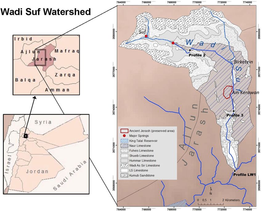
2       Achim Lichtenberger et al.

            committed to address issues on a global scale or with global relevance, both through empirical
            studies and theoretical approaches. Long-term human–environment balances should be at the
            top of the list, but require cross-disciplinary work that few historians possess the necessary skills,
            interest or funding for. Leaving the field to the natural sciences exclusively is not a satisfactory
            option, however. Archaeology and history offer the study of paleo-environmental data as products
            of culturally situated practices, well suited to address the nature of human–environment entan-
            glements in the past.3 While debates on whether and at what point in history the Anthropocene
            becomes a useful analytical term continue,4 pre-modern history may help us appreciate how not
            only our present-day institutions, but also our relationship with the environment relies on cultural
            practices and historical contingencies.5
               How may archaeological and natural science data be integrated more holistically into the devel-
            opment of historical narratives? Below, we argue that one way of facing these challenges and tack-
            ling meaningful integration of data pulled from other disciplines is by zooming in on case studies
            that can be investigated through high-definition perspectives and from multiple angles, and then
            scaling up, by juxtaposing the results with global-scale environmental and historical timelines,
            which are in turn refined by the detailed information offered by the case studies.6 A case study
            approach is crucial since it provides data that contributes to a nuanced regional picture of human–
            environment entanglements in the past. Our chosen case is the city of Jerash in present-day Jordan
            and its relationship to the watercourse that literally runs through the city over a period of more
            than 2500 years (Figure 1). Using an urban biography as a point of departure enables us to identify
            the benign trends and negative stresses that fostered resilience or caused vulnerability, and the
            positive events as well as shocks that in retrospect can be identified as breaking points in the life
            story of Jerash.7 Combining the limited traditional historical record available with archaeology
            and paleo-environmental data, we aim to demonstrate how human and environmental agencies
            both shaped the biography of the city, and how a case study such as that of Jerash may in turn
            contribute back to regional and global-scale historical narratives. Our narrative emphasizes the
            material, economic and ecological aspects of development. This does not come at the expense
            of other aspects of the human past, but reflects the nature of our sources, our ambition to answer
            the calls that historians need to engage with archaeological and scientific data, and our belief that
            the timescale of the longue durée is the optimal framework for doing this.8 As we aim to demon-
            strate below, ideological, cultural and political change is frequently manifested in the material
            record, in most cases arguably as a cause, in other cases also as an effect.

               3
                Michael Lewis, “And All Was Light?—Science and Environmental History”, in The Oxford Handbook of Environmental
            History, ed. Andrew C. Isenberg (Oxford: Oxford University Press, 2014): 207–26.
               4
                Paul J. Crutzen, The “Anthropocene”, in Earth System Science in the Anthropocene, eds. Eckart Ehlers and Thomas Krafft
            (Berlin: Springer, 2006): 13–18; Arlene M. Rosen, Jinok Lee, Min Li, Joshua Wright, Henry T. Wright, and Hui Fang, “The
            Anthropocene and the Landscape of Confucius: A Historical Ecology of Landscape Changes in Northern and Eastern China
            during the Middle to Late-Holocene,” The Holocene 25, no. 10 (2015): 1640–50.
               5
                Joseph G. Manning, The Open Sea: The Economic Life of the Ancient Mediterranean World from the Iron Age to the Rise of
            Rome (Princeton: Princeton University Press, 2018); Paul J. Lane, “Archaeology in the age of the Anthropocene: A critical
            assessment of its scope and societal contributions,” Journal of Field Archaeology 40, no. 5 (2015): 485–98.
               6
                Rubina Raja and Søren M. Sindbæk (eds.), Urban Network Evolutions. Towards a High Definition Archaeology (Aarhus:
            Aarhus University Press, 2018) for a volume which through 40 case studies pioneered such an approach.
               7
                On urban biographies, archaeology and high-definition studies, see the newly published journal issue also for a contribu-
            tion on Jerash: Rubina Raja and Søren M. Sindbæk, “Biographies of Place - An Introduction,” Journal of Urban Archaeology 2
            (2020): 11–4. DOI: 10.1484/J.JUA.5.121525. Rubina Raja and Søren M. Sindbæk, “Urban networks and high–definition
            narratives. Rethinking the archaeology of urbanism,” Journal of Urban Archaeology 2 (2020): 173–86. DOI: 10.1484/
            J.JUA.5.121535. Achim Lichtenberger and Rubina Raja, “Antioch on the Chrysorrhoas – Formerly Called Gerasa.
            Perspectives on Biographies of a Place,” Journal of Urban Archaeology 2 (2020): 151–72.
               8
                Fernand Braudel, “History and the Social Sciences: The Longue Durée,” Review (Fernand Braudel Center) 32, no. 2 (2009):
            171–203.

Downloaded from https://www.cambridge.org/core. IP address: 86.167.134.27, on 16 Apr 2021 at 09:43:03, subject to the Cambridge Core terms of use, available at
https://www.cambridge.org/core/terms. https://doi.org/10.1017/S1740022821000012
Journal of Global History               3

        Figure 1. The Wadi Suf Watershed is the fertile riverine hinterland of Gerasa (modified from Nezar Hammouri and Ali
        El-Naqa, “GIS-based hydrogeological vulnerability mapping of groundwater resources in Jerash area—Jordan,”
        Geofisica Internacional 47 (2008): 85–97; DEM from USGS, 2011).

        Scales of analysis in environmental history
        Scholars approach environmental history on different scales. Much work takes place either on a
        site or location level, or that of a landscape, mostly in the concrete, physical and perceived senses,
        but sometimes generalized to regional on the scales of deserts, forests, rivers, mountains, oceans,
        environs, etc., or on national, continental or global scales. Taking a localized case study as our
        point of departure and explicitly setting out to address different scales of analysis enables us
        to consider agencies and dynamics and the relationship between them from a new perspective.
            Scientific data (submolecular and molecular), archaeological evidence (object, structure, settle-
        ment, hinterland) and documentary sources (individual, group, place) mostly represent geograph-
        ically pinpointed evidence of past processes. In historical narratives, they may be said to offer
        high-definition information.9 The strength of such data is its potential, within margins depending
        on circumstances, to yield secure and testable knowledge. Major weaknesses include the fragmen-
        tary and possibly insecure nature of individual data points as well as datasets. Even the best paleo-
        climatic series have limited accuracy and might only be representative of the site that produced
        them. Archaeological data is shaped by the extent of the survival of the material and the archaeo-
        logical process including excavation methods, interpretations and publication standards. Various
        kinds of documents are notoriously biased and unrepresentative, and rarely directly address the
        issue that the historian is interested in.
           9
            See note 4.

Downloaded from https://www.cambridge.org/core. IP address: 86.167.134.27, on 16 Apr 2021 at 09:43:03, subject to the Cambridge Core terms of use, available at
https://www.cambridge.org/core/terms. https://doi.org/10.1017/S1740022821000012
4 Achim Lichtenberger et al.
With Horden and Purcell’s seminal The Corrupting Sea, the ecological microregion was suggested
as the default unit of analysis for human–nature interaction, constituting a suitable bridge between
the specialized (high-definition) interest of scientists and the social, economic and political questions
raised in most historical studies.10 Micro-ecologies, as Horden and Purcell call them, are shaped by
the natural environment, but defined through the interplay with human risk-management, creating
villages, fields, pastureland, woodlands, etc. For most people in the pre-modern world, much of daily
life and interaction took place within the framework of such crucial ecological systems, which, how-
ever, were also connected within and across wider regions and over longer distances through innu-
merable direct and indirect ties.11 In the case of Jerash, the drainage basin of Wadi Jerash, the river
that runs through the city, represents a clear-cut unit of analysis, allowing the study of human–
nature interplay within a defined system (Figure 1).12 On a somewhat larger scale, the highlands
of Ajlun, a dry-farming region between Lake Tiberias, the Jordan River, the Dead Sea and the
Syrian Desert, also represent a distinct ecological microregion,13 while the historical landscape of
northeastern modern Israel, northern Jordan and southern Syria known in Roman times as the
Decapolis region, has an obvious historiographical relevance, but is much harder to delimit.14
The Decapolis is part of what has been defined as a historical mesoregion, which is an area cross-
ing political and cultural borders, but connected by shared characteristics and frequent interaction.15
The wider mesoregion of the semi-arid Near East (Figure 2), stretching from Jordan to Northern
Syria and Iraq, shares historical traits across time and space, including the related factors of vulnera-
bility to climate change, geopolitical position in the transition zone between agricultural empires and
the deserts, as well as shifting dynamics between nomads and settled populations. This level of ana-
lysis also allows for investigating relations with neighbouring mesoregions, including the Levantine
Mediterranean coast, Eastern Anatolia as well as the Syrian and Arabian Deserts.
Just as the definition of and demarcation between ecological micro- and mesoregions are ques-
tions of scholarly inference rather than the physical environment, the border to the next category,
the macroregions that have arguably been the most widespread units of analysis in ecologically ori-
ented historical scholarship, is pragmatic. Our case study is situated within, but at the margin of the
Mediterranean ecological zone, which has been the object of innumerable studies since Braudel’s La
Méditerranée et le monde méditerranéen à l'époque de Philippe II.16 It is also part of the less clearly
defined macroregion of the Near East or the Levant.17 This scale of analysis is not only useful for
discussing the ecological aspects of Jerash’s history, but also in order to situate our case study in a
10
Peregrine Horden and Nicholas Purcell, The Corrupting Sea: A Study of Mediterranean History (Oxford: Blackwell, 2000),
53–4, 77–80. Also see their recently published follow-up volume of collected writings since 2000: Peregrine Horden and
Nicholas Purcell, The boundless sea. Writing Mediterranean History (London: Routledge, 2020).
11
Horden and Purcell, Corrupting Sea, 122–52.
12
Achim Lichtenberger and Rubina Raja, “The Chora of Gerasa/Jerash,” in Judaea/Palaestina and Arabia: Cities and
Hinterlands in Roman and Byzantine Times, eds. Achim Lichtenberger, Oren Tal and Zeev Weiss (Heidelberg:
Propylaeum, 2019), 109–24.
13
David Kennedy, “The Identity of Roman Gerasa: An Archaeological Approach,” Mediterranean Archaeology 11 (1998):
39–69; David Kennedy, Gerasa and the Decapolis. A ‘virtual island’ in northwest Jordan (London: Duckworth, 2007), 50–83.
14
Hans Bietenhard, “Die syrische Dekapolis von Pompeius bis Trajan,” in Aufstieg und Niedergang der römischen Welt II.8,
eds. Hildegard Temporini and Wolfgang Haase (Berlin: De Gruyter, 1977), 220–61; Kennedy, Gerasa; Achim Lichtenberger,
Kulte und Kultur der Dekapolis. Untersuchungen zu numismatischen, archäologischen und epigraphischen Zeugnissen
(Wiesbaden: Harrassowitz, 2003), 6–20.
15
Stefan Troebst, “Historical meso-region”: a concept in cultural studies and historiography (Mainz: Inst. f. Europ.
Geschichte, 2012).
16
Fernand Braudel, La Méditerranée et le monde méditerranéen à l'époque de Philippe II (Paris: A. Colin, 1949); Later influ-
ential works include Horden and Purcell, Corrupting Sea, 9–49; David Abulafia, The Great Sea: A Human History of the
Mediterranean (Oxford: Oxford University Press, 2011); Cyprian Broodbank, The Making of the Middle Sea: A History of
the Mediterranean from the Beginning to the Emergence of the Classical World (London: Thames & Hudson, 2015);
Manning, The Open Sea.
17
Terje Stordalen and Oystein Sakala LaBianca (eds.), Levantine Entanglements; Local Dynamics of Globalization in a
Contested Region (Sheffield: Equinox, 2021).
Downloaded from https://www.cambridge.org/core. IP address: 86.167.134.27, on 16 Apr 2021 at 09:43:03, subject to the Cambridge Core terms of use, available at
https://www.cambridge.org/core/terms. https://doi.org/10.1017/S1740022821000012Journal of Global History 5
Figure 2. The Semi-Arid Near East, climate, rivers, lakes and isohyets. Data from Hylke E. Beck et al., “Present and future
Köppen-Geiger climate classification maps at 1-km resolution,” Scientific Data 5 (2018): 180214; Simone Riehl and Itzhaq
Shai, “Supra-regional trade networks and the economic potential of Iron Age II sites in the Southern Levant,” Journal of
Archaeological Science: Reports 3 (2015): 525–33.
highly connected geopolitical narrative of empires, migrations, languages, religions, war, disease and
long-distance trade – and so between concepts and developments.
Finally, the global scale of analysis contributes to developments that are likely to have resonated and
thus be visible on the different regional levels, especially within climate history. Trends such as the
Roman Climate Optimum, the Late Antique/Early Medieval Little Ice Age,18 the Medieval Climate
Anomaly and the Early Modern Little Ice Age,19 and events such as the cold decade after 536 CE,20
played out on a global scale, but had different effects and were met in diverse ways in different places.21
Our point of departure is that a holistic understanding of ecological history must address all
these scales of analysis, from high definition to global, and that relationships and carriers of infor-
mation between these scales are identified so they inform each other. In this way case studies also
have the potential to constitute and contribute to macroregional and global history narratives, by
providing details and depth sometimes missing at these scales, offering nuanced narratives with
18
Paul Erdkamp, “War, Food, Climate Change, and the Decline of the Roman Empire,” Journal of Late Antiquity 12, no. 2
(2019): 422–65; Kyle Harper, The Fate of Rome: Climate, Disease, and the End of an Empire (Princeton: Princeton University
Press, 2017).
19
Sarah Kate Raphael, Climate and Political Climate: Environmental Disasters in the Medieval Levant (Leuven: Brill, 2003);
Elena Xoplaki et al., “Modelling Climate and Societal Resilience in the Eastern Mediterranean in the Last Millennium,”
Human Ecology 46, no. 3 (2018): 363–79.
20
Timothy P. Newfield, “The Climate Downturn of 536–50,” in The Palgrave Handbook of Climate History, eds. Sam White,
Christian Pfister and Franz Mauelshagen (London: Palgrave Macmillan, 2018): 447–93.
21
Johannes Preiser-Kapeller, Jenseits von Rom und Karl dem Großen. Aspekte der globalen Verflechtung in der langen
Spätantike, 300–800 n. Chr. (Vienna: Mandelbaum, 2018); Fredrik Charpentier Ljungqvist, Klimatet och människan under
12000 år. (Stockholm: Dialogos, 2017).
Downloaded from https://www.cambridge.org/core. IP address: 86.167.134.27, on 16 Apr 2021 at 09:43:03, subject to the Cambridge Core terms of use, available at
https://www.cambridge.org/core/terms. https://doi.org/10.1017/S17400228210000126 Achim Lichtenberger et al.
the opportunity to avoid linear cause and effect explanations. River systems with their complex
interplay between humans and environment are ideal laboratories for zooming in locally and
scaling up globally.22
A river and its city – a city and its river
The region of Jerash contains one of the largest and longest lasting Neolithic settlements in
Jordan,23 demonstrating its attractiveness and potential for stable human habitation.24 This is
in part due to the presence of the powerful Ain Kerawan spring, and also in part to the river system
of Wadi Jerash, a tributary to the Zarqa River, which in turn drains into the Jordan River.
Together, these features create the necessary conditions for permanent urban settlement and
intensive agriculture.25 Fed by springs at Suf, 8 kilometres northwest of Jerash as well as a larger
catchment area behind Suf, the river was called Chrysorrhoas, ‘Gold-river’, in antiquity, attesting
to its perceived importance as well as prestige in a region where running surface water was rela-
tively scarce.26 While the oldest yet documented urban settlement dates to the Hellenistic period,
most probably the second century BCE,27 the survival and eventual success of the Semitic topo-
nym of Gerasa seem to point towards the existence of an earlier, locally based settlement.28 At one
point during Seleucid rule, the settlement was refounded and officially renamed as Antioch on the
Chrysorrhoas. Adding the name of the river to the toponym, on the one hand, served to distin-
guish this city from the many other Seleucid foundations named Antioch,29 but it also underlined
the importance of the river for the civic identity of the settlement. That the settlement nevertheless
retained its local Semitic name throughout and beyond its urban existence points towards the
resilience of local and possibly also non-urban populations despite a series of imperial initiatives.30
22
Johannes C. Bernhardt, Markus Koller, Achim Lichtenberger (eds.), Mediterranean Rivers in a Global Perspective
(Paderborn: Schöningh, 2019).
23
Maysoon Al-Nahar, “The Neolithic Site of Tell Abu Suwwan in Jerash, Jordan,” in The Archaeology and History of Jerash:
110 Years of Excavations, eds. Achim Lichtenberger and Rubina Raja (Turnhout: Brepols, 2018), 7–14.
24
See David D. Boyer, “The Role of Landscape in the Occupational History of Gerasa and its Hinterland,” in Lichtenberger
and Raja, Archaeology and History, 59–86; Also David Boyer, “An Analysis of the Historical Water Management System to
Gerasa in the period 100 BC to AD 700” (PhD diss. University of western Australia, 2019), 50–1.
25
Boyer, “Analysis”, 68–80.
26
Kennedy, Identity, 55; Kennedy, Gerasa, 69–70; Achim Lichtenberger and Rubina Raja, “Water management in the
North-West Quarter of Gerasa/Jerash,” in Gerasa/Jerash: From the Urban Periphery, eds. Achim Lichtenberger and
Rubina Raja (Aarhus: Fællestrykkeriet AU, 2017) 121–9; Achim Lichtenberger and Rubina Raja, “Living with and on the
river-side. The example of Roman Antioch-on-the-Chrysorrhoas-formerly-called-Gerasa,” in Water of Life : Essays from a
symposium held on the occasion of Peder Mortensen’s 80th birthday, eds. John Kuhlmann Madsen, Niels Overgaard
Andersen and Ingolf Thuesen (Copenhagen: Forlaget Orbis, 2016), 98–115; Achim Lichtenberger, “Antioch at the
Chrysorrhoas – Gerasa, but which river?,” Syria 96 (2019): 471–6.
27
Jacques Seigne, “De la grotte au périptère. Le sanctuaire de Zeus à Jerash,’’ Topoi. Orient-Occident 7, no. 2 (1997):
993–1004; Getzel M. Cohen, The Hellenistic Settlements in Syria, the Red Sea Basin, and North Africa (Berkeley:
University of California Press, 2006), 248–53; Nathanael J. Andrade, Syrian Identity in the Greco-Roman World
(Cambridge: Cambridge University Press, 2013), 162; Achim Lichtenberger and Rubina Raja, “New archaeological research
in the Northwest quarter of Jerash and its implications for the urban development of Roman Gerasa,” American Journal of
Archaeology 119, no. 4 (2015): 483–500.
28
Carl Hermann Kraeling, Gerasa: city of the Decapolis: an account embodying the record of a joint excavation conducted by
Yale University and the British School of Archaeology in Jerusalem (1928–1930), and Yale University and the American Schools
of Oriental Research (1930–1931, 1933–1934) (New Haven Conn: American Schools of Oriental Research, 1938), 27–30;
Achim Lichtenberger, “Artemis and Zeus Olympios in Roman Gerasa and Seleucid religious policy”, in The Variety of
Local Religious Life in the Near East in the Hellenistic and Roman Periods, ed. Ted Kaizer (Leiden and Boston: Brill,
2008), 133–53; Rubina Raja, R. Urban Development and Regional Identity in the Eastern Roman Provinces, 50 BC – AD
250: Aphrodisias, Ephesos, Athens, Gerasa (Copenhagen: Museum Tusculanum Press, 2012); Rubina Raja, “Changing spaces
and shifting attitudes: Revisiting the Sanctuary of Zeus in Gerasa,” in Cities and Gods: Religious Space in Transition, eds.
T. Kaizer, A. Leone, E. Thomas and R. Witcher (Leuven: Peeters, 2013), 31–46.
29
Cohen, Hellenistic Settlements.
30
See now the critical assessment by Pierre-Louis Gatier, “Antioche du Chrysorhoas,” Topoi 22, no. 1 (2018): 225–49.
Downloaded from https://www.cambridge.org/core. IP address: 86.167.134.27, on 16 Apr 2021 at 09:43:03, subject to the Cambridge Core terms of use, available at
https://www.cambridge.org/core/terms. https://doi.org/10.1017/S1740022821000012Journal of Global History 7
Jerash came under Roman rule with Pompey’s conquest of Syria in 63 BCE, which also became
the starting point of its civic era.31 The impressive architectural record that remains visible today
to a large degree stems from the second and third centuries CE (Figure 3).32 Urban development in
the Late Roman and Early Islamic period is also visible, through numerous churches, a large late
antique synagogue and two early mosques.33 The Byzantine and Umayyad periods stand forth as a
prosperous time for the city, despite evidence that the city was hit hard by the Justinianic Plague,
which is seen through the discovery in the (by then abandoned) hippodrome of 2 mass graves of
the mid-seventh century CE containing an estimated 230 plague victims,34 and, counter to earlier
assessments, the transition from Roman to Arab rule seems not to have disturbed the urban life to
any significant degree,35 although, as we shall see, this image is complicated by data from the riv-
erine hinterland of the city. The earthquake that struck the region in the morning of January 18
749 CE,36 however, had devastating consequences for Jerash. Only a small urban nucleus survived
in the short run, and this was also abandoned over time.37 Left to occasional squatters and the
seasonal presence of nomadic pastoralists for an extended period of time, a limited resettlement
took place in the middle Islamic period.38 The site was again all but given up and remained deso-
late until the arrival of Circassian settlers in 1878, which marked the start of modern urban devel-
opment.39 The Circassian and Arab populations have since been joined by considerable
contingents of Palestinian refugees, and present-day Jerash is a rapid-growing, medium-sized city,
relying on tourism and challenged with balancing urban growth with heritage management and
pressure on land and water resources.40
31
Lichtenberger, Kulte und Kultur, 192; Cohen, Hellenistic, 249. Rubina Raja, Urban Development and Regional Identity in
the Eastern Roman Provinces, 50 BC – AD 250: Aphrodisias, Ephesos, Athens, Gerasa (Copenhagen: Museum Tusculanum
Press, 2012), 149.
32
Kraeling, Gerasa, 11–25, 73–158; Seigne, ‘De la grotte’; Andrade, Identity, 162–3; Lichtenberger and Raja, ‘Archaeological
Research’, 482–5.
33
Kraeling, Gerasa, 265–294; John Winter Crowfoot, “The churches of Gerasa, 1928, 1929,” Palestine Exploration Quarterly
62, no. 1 (1930): 32–42; Estēe Dvorjetski, “The Synagogue-Church at Gerasa in Jordan. A Contribution to the Study of Ancient
Synagogues,” Zeitschrift des Deutschen Palästina-Vereins 121, no. 2 (2005): 140–67; Alan George Walmsley, Early Islamic
Syria: An Archaeological Assessment (London: Duckworth, 2007), 83–7; Achim Lichtenberger and Rubina Raja, “From
Synagogue to Church. The Appropriation of the Synagogue of Gerasa/Jerash under Justinian,” Jahrbuch für Antike und
Christentum 61 (2018): 85–100.
34
Ina Kehrberg and Antoni A. Ostrasz, “Ancient Burials at the Hippodrome of Gerasa/Jarash,” Annual of the Department of
Antiquities of Jordan 58 (2017): 131–218; Michael McCormick, “Tracking Mass Death During the fall of Rome’s Empire (I),”
Journal of Roman Archaeology 28 (2015): 325–57.
35
Michal Gawlikowski, “Jerash in early Islamic times,” Oriente Moderno 84, no. 2 (2004): 469–76.
Lichtenberger and Raja, ‘Archaeological research’, 489; Walmsley, Early Islamic, 83–7; Achim Lichtenberger and Rubina
Raja, “Defining Borders: The Umayyad-Abbasid Transition and the Earthquake of AD 749 in Jerash,” in Byzantine and
Umayyad Jerash reconsidered. Transitions, Transformations, Continuities, eds. Achim Lichtenberger and Rubina Raja
(Turnhout: Brepols, 2019), 265–86.
36
Shmuel Marco, Moshe Hartal, Nissim Hazan, Lilach Lev, and Mordechai Stein, “Archaeology, History, and Geology of the
A.D. 749 Earthquake, Dead Sea Transform,” Geology 31, no. 8 (2003): 665–8.
37
Achim Lichtenberger, Rubina Raja, Christoph Eger, Georg Kalaitzoglou, and Annette Højen Sørensen, “A Newly
Excavated Private House in Jerash. Reconsidering Aspects of Continuity and Change in Material Culture from Late
Antiquity to the Early Islamic Period,” Antiquité Tardive 24 (2016): 317–59; Louise Blanke, “Abbasid Jerash
Reconsidered: Suburban Life in Jerash’s Southwest District over the Longue Durée,” in The Archaeology and History of
Jerash: 110 Years of Excavations, eds. Achim Lichtenberger and Rubina Raja (Turnhout: Brepols, 2018), 39–57; Achim
Lichtenberger and Rubina Raja, eds. Middle Islamic Jerash (9th Century–15th Century). Archaeology and History of an
Ayyubid-Mamluk Settlement (Brepols: Turnhout, 2018).
38
Lichtenberger and Raja, Middle Islamic Jerash.
39
Kraeling, Gerasa, ix.
40
Achim Lichtenberger and Rubina Raja, Late Hellenistic and Roman Antioch on the Chrysorhoas, also called Gerasa.
A reappreciation of the evidence in the light of the findings of the Danish-German Jerash Northwest Quarter Project
(2011–2017), in Hellenistic and Roman Gerasa. The archaeology and history of a Decapolis city, eds. Achim Lichtenberger
and Rubina Raja (Brepols: Turnhout, 2020), 7–54.
Downloaded from https://www.cambridge.org/core. IP address: 86.167.134.27, on 16 Apr 2021 at 09:43:03, subject to the Cambridge Core terms of use, available at
https://www.cambridge.org/core/terms. https://doi.org/10.1017/S17400228210000128 Achim Lichtenberger et al.
Figure 3. Map of Gerasa (Achim Lichtenberger, Rubina Raja and David Stott, “Mapping Gerasa: a new and open data map of
the site,” Antiquity 93.367 (2019): e7 DOI: https://doi.org/10.15184/aqy.2019.9).
Downloaded from https://www.cambridge.org/core. IP address: 86.167.134.27, on 16 Apr 2021 at 09:43:03, subject to the Cambridge Core terms of use, available at
https://www.cambridge.org/core/terms. https://doi.org/10.1017/S1740022821000012Journal of Global History 9
Figure 4. East-West section through the city of Gerasa (Gottlieb Schumacher, “Dscherash,” Zeitschrift des Deutschen
Palästina-Vereins 25 (1902): 109–77).
The river in the city
Gerasa was encircled by city walls and the city had a main thoroughfare, a colonnaded street run-
ning from north to south about 1.2 kilometres long. It is bisected by two other colonnaded streets
running east-west.41 The city itself is divided into an eastern and a western part by the steep wadi
(riverbed) (Figure 4). Crossing between the east and west parts of Jerash was in antiquity provided
by several bridges.42 The wadi and the bridges had a profound impact on the urban movement.
After the bridges fell out of use, the connections between the east and the west side of the city were
interrupted and it is not by chance that when modern resettlement was begun, it did not extend
across the wadi, but was restricted to the east side of the site. Since the Kerawan spring and the
wadi lay on lower ground than the western part of the city, water supply to most parts of the city
that were on higher altitude had to be provided by a complex system of aqueducts, cisterns and
pipes leading the water from the upstream area of Suf into the city and its adjacent fields.43
Furthermore, without active management, the steepness of the wadi resulted in substantial erosion
and water-related soil movement, both persistent over extended periods of time and by more
extreme events such as landslides.
How is the history of a site like Jerash connected with changing variables such as climate, sub-
sistence, geopolitics, disease and natural disaster? Answers might be sought at a range of inter-
connected scales, all of which, however, may be reflected in the natural archive of the sediments
left by the river that gave life and for a while name to the city.
Microregional context: the Jerash–Wadi Suf watershed
Understanding the microregional context of Jerash, defined here as the Jerash–Wadi Suf water-
shed through time, requires careful integration of the natural sciences, archaeological survey and
historical sources. Enabled by the aeolian (windborne) deposition of quartz containing Saharan
dust throughout the Pleistocene,44 optically stimulated luminescence (OSL) profiling and dating of
sedimentary sequences trace patterns of sediment movement within the wadi that reflect phases of
41
M. Tabaczek, Zwischen Stoa und Suq. Die Säulenstraßen im Vorderen Orient in römischer Zeit unter besonderer
Berücksichtigung von Palmyra (PhD dissertation Cologne, 2002), 161–86; Ross Burns, Origins of the Colonnaded Streets
in the Cities of the Roman East (Oxford: Oxford University Press, 2017).
42
Lichtenberger and Raja, ‘Living with and on’.
43
Boyer, “Analysis”, 81–93.
44
Arie S. Issar and Hendrik J. Bruins, ‘Special Climatological Conditions in the Deserts of Sinai and the Negev during the
Latest Pleistocene’, Paleogeography, Palaeoclimatology, Palaeoecology 43, no. 1–2 (1983): 63–72; Arie S. Issar et al., “A
Paleoclimatic Model to Explain Depositional Environments during Late Pleistocene in the Negev,” in In Progress in
Desert Research, eds. Louis Berkofsky and Morton G. Wurtele (Totowa: Rowman & Littlefield, 1987), 302–9; Bernhard
Downloaded from https://www.cambridge.org/core. IP address: 86.167.134.27, on 16 Apr 2021 at 09:43:03, subject to the Cambridge Core terms of use, available at
https://www.cambridge.org/core/terms. https://doi.org/10.1017/S174002282100001210 Achim Lichtenberger et al.
stable landscape, accumulation of waterborne (fluvial) sediments and movement of (colluvial)
sediments down slopes.45 These science-based observations give interpretations of the upper wadi
(above Jerash city; Profile 2, Figure 1) as an intact landscape with little or no sediment movement
and a freely flowing river until 640 ± 240 CE. This suggests a balanced and continuous manage-
ment of the fluvial landscape that regulated floods and preserved soil. Subsequent to this, water-
borne sedimentation and wadi infilling through to 760 ± 40 CE suggest the beginnings of land
degradation with declining maintenance of agricultural infrastructures. From 760 ± 40 CE, slope
movement sediment deposition indicates a further acceleration of land degradation and a severely
compromised agricultural infrastructure on the wadi slopes. Analyses of the middle wadi catch-
ment (below/south of Jerash city; Profile 3, Figure 1 indicate that waterborne sediment accumu-
lation continued, but that slopes remained intact until 1400 ± 60 CE. Slope wash sediment
deposition points towards accelerating land degradation after this point of time. Further down
in the lower wadi catchment (Profile LW1, Figure 1), waterborne sediment accumulation com-
menced from 510 ± 310 BCE, paralleling dates from soils underlying Jerash, until 760±40 CE
when, as in the upper wadi, slope wash sediments and accelerating degradation becomes evident.
Notwithstanding the beginnings of limited waterborne sediment accumulation in the lower
wadi that indicates initial catchment disturbance associated with the onset of urbanization in
the second century BC, the sediment sequences testify to a stable and intact catchment with
no indication of over-exploitation until 640 ± 240 CE. Although much work remains to be under-
taken on the landscape archaeology and history of this microregion, the evidence points to careful
landscape management of both soil and water resources in the upper wadi. A Roman-period
inscription associates the upper wadi area with the ‘gardeners of the upper valley’,46 and, although
yet to be dated, the extensive agricultural terraces enhancing crop rooting depth and water holding
capacity may have their origins in this period,47 maintaining and provisioning the Roman-period
oil presses found in and around Jerash.48 Similarly, water management infrastructures were devel-
oped during this era, including the introduction of water gates regulating water reaching the city,
the creation of the Birketein cistern complex and soils-based evidence of micro sediments associ-
ated with irrigation practice in the vicinity of the early city.49 These archaeological indicators point
to a strong and centralized urban–hinterland governance and robust social and economic net-
works within a fluctuating climate, but with increasing precipitation. This was an internally con-
tained microregion, networked economically with its meso- and macro regions in variable but
untroubling environmental conditions regulated by careful management.
The onset of waterborne sediment accumulation beginning to infill the upper wadi within the
wide time bracket of 640 ± 240 CE indicates local soil erosion from previously stable agricultural
Lucke et al., “Red Mediterranean Soils in Jordan: New Insights in their Origin, Genesis, and Role as Environmental Archives,”
Catena 112 (2014): 4–24.
45
Achim Lichtenberger et al., “Urban-Riverine Hinterland Synergies in Semi-Arid Environments: Millennial- Scale Change,
Adaptations, and Environmental Responses at Gerasa/Jerash,” Journal of Field Archaeology 44, no. 4 (2019): 333–51.
46
Pierre-Louis Gatier, “Nouvelles inscriptions de Gérasa,” Syria 62 (1985): 297–312; Lichtenberger and Raja, ‘Living with’;
Jacques Seigne, “Remarques préliminaires à une étude sur l’eau dans la Gerasa antique,” in Men of Dikes and Canals: The
Archaeology of Water in the Middle East. International symposium held at Petra, Wadi Musa (H.K. of Jordan) 15–20
June, 1999, eds. Hans-Dieter Bienert and Jutta Häser (Rahden: M. Leidorf, 2004), 173–85.
47
Brian Beckers and Brigitta Schütt, “The Chronology of Ancient Agricultural Terraces in the Environs of Petra,” in Men on
the Rocks: The Formation of Nabataean Petra, eds. Michel Mouton and Stephan. G. Schmidt (Berlin: Logos, 2013), 313–22;
Gershon Edelstein and Mordechai E. Kislev, “Mevasseret Yerushalayim: The Ancient Settlement and its Agricultural
Terraces,” The Biblical Archaeologist 44, no 1 (2015): 53–6; Zvi Ron, ‘Agricultural Terraces in the Judean Mountains’,
Israel Exploration Journal 16 (1966): 33–49, 111–22.
48
Georg Kalaitzoglou, Achim Lichtenberger, and Rubina Raja, “Preliminary Report of the Second Season of the Danish-
German Jarash Northwest Quarter Project 2012,” Annual of the Department of Antiquities of Jordan 57 (2013): 57–79.
49
Lichtenberger et al., ‘Urban-riverine’; Lichtenberger and Raja, ‘Living with’; Ian Simpson, Achim Lichtenberger and
Rubina Raja, unpublished data. Also see Achim Lichtenberger and Rubina Raja, Management of water resources over time
in semi-arid regions: The case of Gerasa/Jerash in Jordan, WIREs Water 2019; e1403, 1–19; Boyer, “Analysis”.
Downloaded from https://www.cambridge.org/core. IP address: 86.167.134.27, on 16 Apr 2021 at 09:43:03, subject to the Cambridge Core terms of use, available at
https://www.cambridge.org/core/terms. https://doi.org/10.1017/S1740022821000012Journal of Global History 11
land surfaces, with land management, organization and regulation less effective in responding to a
series of interrelated meso- and macroregional stresses. These include significant and well docu-
mented dry periods in the paleo-climatic record c. 536–800 CE affecting socio-economic shocks
and coinciding with a decline in long-distance trade across the eastern Mediterranean,50 the
impact of the recurring Justinianic Plague pandemic that commenced 540–541 CE and which
had a real immediacy for Jerash as evidenced in the mid-seventh-century mass graves uncovered
in the hippodrome, and a 540–640 CE century of regional Sassanian and Roman conflict followed
by Arab invasion.51 The ‘perfect storm’ of these existential events was a tipping point for this
microregion with the Wadi River at no point after c. 640 CE being the free-flowing
Chrysorrhoas of antiquity,52 and whose impacts may yet be seen, with further research, in the
agricultural landscape infrastructure of the wadi and in the archaeology of households. These
events also served to reduce physical and social resilience in the microregion to future environ-
mental and social stresses. Evidence from other microregions indicates that post-tipping point
scenarios include the prospect of a greater likelihood of new and more frequent major changes
in the complex relationships between societies and their environments.53
Slope wash deposits superimposed on the waterborne deposits and commencing from 760 ± 40
CE are best explained as a result of the 749 CE earthquake superimposed on an agricultural system
and city, already in decline. Factors contributing to a decline in land management again included
difficult dry climatic conditions, the Umayyad–Abbasid conflict 747–750 CE and possibly the
regional plague outbreak of 744 CE; these circumstances would have further accentuated the fail-
ure of the remaining agricultural terraces and associated irrigation systems.54 After the earth-
quake, the city was largely abandoned not simply because of the earthquake, but because of
the vulnerabilities inherited from earlier societal and environmental changes together with meso-
and macroregional mediated impacts. Slope wash deposits are also evident in the middle wadi
below the city, but only commencing post 1400 ± 60 CE, prior to which waterborne sediments
continued to accumulate. This continuation implies contrasting microregional responses with
land management here was sufficiently careful for slopes to remain intact until 1400 ± 60 CE.
This opens the possibility that while agriculture was largely abandoned on upper and lower wadi
locations post the 749 CE earthquake, agriculture had contracted to the middle wadi just below the
remaining city. These slope failure indicators from 1400 ± 60 CE may be tentatively related to
Ayyubid–Mamluk city abandonment after the eleventh/twelfth-century CE resettlement of
50
Ulf Büntgen et al., “Cooling and societal change during the Late Antique Little Ice Age from 536 to around 660 AD,”
Nature Geoscience 9, no. 3 (2016): 231–6; Yehouda Enzel et al., “Late Holocene Climates of the Near East Deduced from Dead
Sea Level Variations and Modern Regional Winter Rainfall,” Quaternary Research 60, no. 3 (2003): 263–73; Martin Finné
et al., “Climate in the Eastern Mediterranean, and adjacent Regions, during the Past 6000 Years – A Review,” Journal of
Archaeological Science 38, no. 12 (2011): 3153–73; Kyle Harper and Michael McCormick, “Reconstructing Roman
Climate,” in The Science of Roman History: Biology, Climate, and the Future of the Past, ed. Walter Scheidel (Princeton:
Princeton University Press, 2018), 11–52; Arie S. Issar and Mattanyah Zohar, Climate Change : Environment and History
of the near East (Berlin: Springer, 2007); Ian Orland et al., “Climate Deterioration in the Eastern Mediterranean as revealed
by Ion Microprobe Analysis of a Speleothem that Grew from 2.2 to 0.9 ka in Soreq Cave, Israel,” Quaternary Research 71, no. 1
(2009): 27–35; Newfield, ‘The Climate Downturn’; John Haldon, Byzantium in the Seventh Century: The Transformation of a
Culture (Cambridge: Cambridge University Press, 1990).
51
Mischa Meier, “The ‘Justinianic Plague’: The Economic Consequences of the Pandemic in the Eastern Roman Empire and
its Cultural and Religious Effects,” Early Medieval Europe 24 (2016): 267–92; Kehrberg and Ostrasz, ‘Ancient Burials’.
52
John Haldon, The Empire That Would Not Die: The Paradox of Eastern Roman Survival 640–740 (Harvard: Harvard
University Press, 2016). Alan Walmsley, “Economic Developments and the Nature of Settlement in the Towns and
Countryside of Syria-Palestine, ca. 565–800,” Dumbarton Oaks Papers 61 (2007): 319–52.
53
Keir Magalie Strickland et al., “Hydraulic complexities: Collapse and resilience in Sri Lanka,” in Water and Society: From
Ancient Times To The Present, eds. Federica Sulas and Innocent Pikirayi (Routledge: London, 2018), 259–81; Margaret C.
Nelson, ‘‘Climate challenges, vulnerabilities and food security,” Proceedings of the National Academy of Sciences 113
(2016): 298–303.
54
Lichtenberger et al., ‘Urban-Riverine’.
Downloaded from https://www.cambridge.org/core. IP address: 86.167.134.27, on 16 Apr 2021 at 09:43:03, subject to the Cambridge Core terms of use, available at
https://www.cambridge.org/core/terms. https://doi.org/10.1017/S174002282100001212 Achim Lichtenberger et al.
Jerash, which saw investment in water management infrastructure during a period of favourable
climatic conditions and expanding long-distance trade.55
The water system of Jerash and its hinterland entailed extensive infrastructure and careful man-
agement that can be traced from well before the first evidence of urban settlement until the mod-
ern period.56 The evidence of observed spatial and temporal sedimentary sequences in the
microregion add to this, representing outcomes of attempts to control the environment, or lack
of such, in the form of complex wadi watershed responses to meso- and macroregional environ-
mental and social changes, mediated by local management activities, and so challenge the wider
archaeological and paleo-environmental record for an explanation. In doing so, nuanced narra-
tives of urban–hinterland relationships and their nesting within wider spatial and temporal scales
become possible. On the Jerash–Wadi Suf scale, microregional evidence highlights the significance
of proactive governance and management of meso- and macroregional drivers of change to ensure
the viability of urban and hinterland cultural landscapes. In contrast, inherited vulnerabilities
together with new meso- and macroregional social and environmental impacts are reflected in
the failure of management and loss of landscape integrity.
Mesoregional context: the semi-arid Near East
While urban settlement at Jerash has a start, a series of peaks, lows, unknowns and even hiatuses,
the ecological microregion was never abandoned. Fewer details are known due to the scarcity and
nature of evidence, but the semi-arid Near East, including the highlands of Ajlun, has been home
to sheep- and goat herding pastoralist groups since the late Neolithic,57 and to camel nomads since
the early first millennium BCE.58 Fluctuations in land use between settled agriculture and pasture-
land has traditionally been explained by two mechanisms. Nomads seem to have encroached on
agricultural land in periods of either dry climate and/or weak government. The theoretical lower
annual precipitation limit for the cultivation of barley (Hordeum vulgare) is 200 mm. Farmers
operating near this limit, however, will experience harvest failure in the regularly occurring
dry years. This will have to be compensated by a working market economy or other redistributive
systems that supplies food to the farming population in such cases. Investment in hydraulic infra-
structure as that evidenced in the urban core and hinterland of Jerash (bridges, water gates, ter-
races, cisterns, aqueducts, etc.) requires a certain security and stability. In dry periods, the
historical limit of settled agriculture has generally moved towards the 400 mm isohyet, where sta-
ble harvests may be expected even in dry years.59
For the region of Jerash, the closest paleo-climatological series results from studies of changes
in the sea level of the Dead Sea and from speleothems from the Soreq caves west of Jerusalem. Both
have relevance to Jerash beyond the geographical proximity (c. 80 kilometres). Water flows into
the Dead Sea from the north, including from Wadi Jerash, by way of the Jordan River, and the sea
level is thus in part a product of rainfall in the region.60 The records from the Soreq caves reflect
55
Lichtenberger and Raja, ‘Middle-Islamic’; Lichtenberger et al., ‘Urban-Riverine’.
56
Boyer, “Analysis”.
57
Kay Prag, “Ancient and Modern Pastoral Migration in the Levant,” Levant 17 (1985): 81–8; Mohammad B. Tarawneh and
Fawzi Q. Abudanah, “Subsistence of early pastoral nomadism in the southern Levant: new data from eastern Bayir,” Syria.
Archéologie, art et histoire 90 (2013): 231–52; Oystein Sakala LaBianca, Lorita E. Hubbard and Leona Glidden Running,
Sedentarization and Nomadization: Food System Cycles at Hesban and Vicinity in Transjordan (Berrien Springs: Andrews
University Press, 1990).
58
Jan Retsö, “The Domestication of the Camel and the Establishment of the Frankincense Road from South Arabia,”
Orientalia Suecana 40 (1991): 187–219; Steven A. Rosen and Benjamin A. Saidel, “The Camel and the Tent: An
Exploration of Technological Change among Early Pastoralists,” Journal of Near Eastern Studies 69, no. 1 (2010): 63–77.
59
Norman N. Lewis, Nomads and Settlers in Syria and Jordan, 1800–1980 (Cambridge: Cambridge University Press, 1987);
Arie S. Issar and Mattanyah Zohar, Climate Change: Environment and History of the near East (Berlin: Springer, 2007).
60
Revital Bookman et al., “Quaternary Lake Levels in the Dead Sea Basin: Two Centuries of Research,” Geological Society of
America Special Paper 401 (2006): 155–70.
Downloaded from https://www.cambridge.org/core. IP address: 86.167.134.27, on 16 Apr 2021 at 09:43:03, subject to the Cambridge Core terms of use, available at
https://www.cambridge.org/core/terms. https://doi.org/10.1017/S1740022821000012Journal of Global History 13
cyclone activity in the Mediterranean that feeds winter rains near Jerash as well as near Jerusalem.
While the series and their interpretations differ, the general picture is that of comparably wet
conditions from the initial phases of urban development at Jerash and throughout the phase
of intensive building activity until ca 200 CE.61 This coincides with what is known as the
Roman Warm Period/Roman Climate Optimum. Reviews of regional paleo-climatological studies
in the Levant show a similar pattern of fluctuations between dry and wet periods, but are not in
agreement on chronology.62 This might have to do with the significant margins involved in dating
different series.63 After 200 CE, most studies suggest generally drier, but also more variable cli-
mate. One recent assessment combining environmental with a variety of archaeological proxies
and historical data suggest that this culminated in a so-called megadrought ca 350–470 CE, fol-
lowed by two centuries of historically wet conditions ca 470–670 CE.64 This period of generally
favourable climate, however, was interrupted by a spell of abrupt cooling and dry conditions fol-
lowing the volcanic 536 CE climate event.65 There is general agreement that conditions in the
Levant became drier than they had been during the Roman Warm- and Byzantine periods from
the late seventh century until the ninth century and that conditions became more benign after
that.66 Xoplaki et al. have compared paleo-climatological proxies and modelled precipitation
and temperature with the (also modelled) 1651–1850 average. They identify subperiods within
the Crusader, Mamluk and Ottoman periods with increased environmental stress, the two former
being of special relevance to Jerash.
As pointed out by Xoplaki et al. for the second millennium CE and as demonstrated by the
different timelines in reconstructions of climatic fluctuations in the mid-first millennium, local
climates within the mesoregion might have behaved differently, and the dating of various proxies
remains too inaccurate to draw conclusions about correlation and much less causation between
changing climate and short-term societal developments.67 Some more general observations may,
however, be made with regard to Jerash and climate change on the mesoregional level based on the
archaeological record from the city and the soil record from the riverine hinterland. The start and
first peak of urban development take place during the relatively wet conditions of the Roman
Warm Period. Urban life continues through the late Roman mega-drought of the late fourth
and fifth centuries. While urban building activity decreases after c. 200–250 CE and turns towards
churches from the fourth century CE, this is an empire-wide trend in the Roman world, and drier
climate is not directly reflected in the urban archaeological record, and also cannot at the present
be traced in the riverine sediments, indicating a degree of urban resilience and the upkeep of agri-
cultural and hydrological infrastructure. There is evidence for negative effects on the urban
61
Yehouda Enzel, Amotz Agnon and Mordechai Stein, “Late Holocene Lake Levels of the Dead Sea,” Geological Society of
America Bulletin 116, no. 5–6 (2004): 555–71; Ian J. Orland et al., “Climate Deterioration in the Eastern Mediterranean as
Revealed by Ion Microprobe Analysis of a Speleothem that Grew from 2.2 to 0.9 ka in Soreq Cave, Israel,” Quaternary Research
71, no. 1 (2009): 27–35; Kyle Harper and Michael McCormick, ‘‘Reconstructing Roman Climate,” in The Science of Roman
History: Biology, Climate, and the Future of the Past, ed. Walter Scheidel, (Princeton: Princeton University Press, 2018), 11–52.
62
Harper and McCormick, ‘Reconstructing’; Adam Izdebski et al., “The Environmental, Archaeological and Historical
Evidence for Regional Climatic Changes and their Societal Impacts in the Eastern Mediterranean in Late Antiquity,”
Quaternary Science Reviews 136 (2016): 189–208; Inga Labuhn et al., ‘‘Climatic Changes and their Impacts in the
Mediterranean during the first millennium AD,” Late Antique Archaeology 12, no. 1 (2016): 65–88.
63
Izdebski et al., ‘The Environmental Evidence’, 196.
64
Izdebski et al., ‘The Environmental Evidence’, 196.
65
Izdebski et al., ‘The Environmental Evidence’, 197; Timothy P. Newfield, ‘The Climate Downturn’; Matthew Toohey et al.,
“Climatic and Societal Impacts of a Volcanic Double Event at the Dawn of the Middle Ages,” Climatic Change 136, no. 3–4
(2016): 401–12.
66
Orland et al., ‘Climate’; Harper and McCormick, ‘Climate change’; Izdebski et al, ‘The Environmental evidence’, 196; Issar
and Zohar, Climate Change, 217–19; Labuhn et al., ‘Climatic Changes’; Xoplaki et al., ‘Modelling Climate’.
67
Xoplaki et al. ‘Modelling Climate’; Labuhn et al. ‘Changes’; Izdebski et al, ‘The Environmental evidence’, Harper and
McCormick, ‘Reconstructing’.
Downloaded from https://www.cambridge.org/core. IP address: 86.167.134.27, on 16 Apr 2021 at 09:43:03, subject to the Cambridge Core terms of use, available at
https://www.cambridge.org/core/terms. https://doi.org/10.1017/S1740022821000012You can also read