Google Street View, special data storage for Building Archaeology
←
→
Page content transcription
If your browser does not render page correctly, please read the page content below
Google Street View, special data storage for Building Archaeology
The case of Ss. Stefano e Silvestro Church reconstruction, L’Aquila-Italy

Antonella FURNO

Università degli Studi di Siena, Dipartimento di Scienze storiche e dei Beni culturali

Abstract: Each building archaeology project includes several phases: a preliminary stage in which the aims
of the project are identified, a fieldwork phase in which all the necessary records are collected and a final
phase of restitution in which the recordings are analyzed and oriented on each topographical point with the
production of orthophotos to achieve a high level of knowledge of the architectural structure taken under
analysis. At this point, all the archaeological cognitive instruments (like stratigraphic interpretation,
cronotipology of the material used, construction techniques, characteristics of the mortars, mensiocronology)
can be applied to the stonework in order to obtain the necessary information to understand the work in
progress history of the building. Thanks to the introduction of digital methods, information recording has
undergone a revolution that has allowed the management of numerous archives. In this context, I suggest to
analyze the importance of managing a digital archive of all the metadata related to it and the opportunity to
use Google Maps tool “Google Street View” as a special data storage of images. On these bases, we
attempted to reconstruct a 3D model of SS. Stefano e Silvestro Church in the small town of Castelnuovo
(L’Aquila-Italy) in the district of San Pio delle Camere, which was completely destroyed by the April 2009
earthquake. The wireframe of the church was rebuilt by deducing the minimum metric information, using the
plan of the church derived from the archive of the land register. I used the helpful tool AutoCAD, relying
wholly on Google Street View images and topographical points taken after the quake. A good result, if we
consider the images low resolution, but it has to be taken into account that Google holds the original photos
and the so called .raw files containing all the metadata necessary to provide the technical information.

Keywords: building archaeology, Google Street View, earthquake, metadata management

Introduction
Each building archaeology project includes several phases: a preliminary stage in which the aims of the
project are identified, a fieldwork phase in which all the necessary records are collected and a final phase of
restitution in which the recordings are analyzed and oriented on each topographical point with the production
of orthophotos to achieve a high level of knowledge of the architectural structure taken under analysis. At
this point, all the archaeological cognitive instruments (like stratigraphic interpretation, cronotipology of the
material used, construction techniques, characteristics of the mortars, mensiocronology) can be applied to
the stonework in order to obtain the necessary information to understand the work in progress history of the
building. Thanks to the introduction of digital methods, information recording has undergone a revolution that
has allowed the management of numerous archives. In this context, I suggest to analyze the importance of
managing a digital archive of all the metadata related to it and the opportunity to use Google Maps tool
“Google Street View” as special data storage of images. On these bases, we attempted to reconstruct a 3D
International Conference on Cultural Heritage and New Technologies | Vienna | 2012

model of SS. Stefano e Silvestro Church in the small town of Castelnuovo (L’Aquila-Italy) in the district of
San Pio delle Camere, which was completely destroyed by the April 2009 earthquake.

Principal phases of building archaeology’s project
Building archaeology, in order to obtain historical knowledge and to know significant evolutions of
architectural structure, uses various surveying systems with the support of photogrammetry software that
improves this topographical work. Each project can have a different method that depends on the specific
aims of the project, but in general terms the knowledge of architectural structure can be divided in different
phases: preliminary phase, fieldwork phase and post processing phase.

Preliminary phase
The first part of the project is a decisive moment in which the user has necessarily to evaluate the aims of
the project. The outcome of a survey project has to be achieved through a cooperation between the surveyor
and the supposed survey user in order to meet its specific purpose, for example a restoration work. The final
uses of survey data are different and may include monitoring, project planning, stylistic analysis, ante-
disaster records, condition records and intervention plans. A short statement of why a survey is needed will
help a correct decision on the method of data capture which is required for optimum data usability.

Fieldwork
Metric survey techniques can be divided into two groups: indirect and direct. Indirect techniques (such as
photogrammetry and laser scanning) are used when there is a need for undifferentiated metric data or when
the size of the subject and its scale of representation require a high density of point capture. The primary
data sets from indirect techniques are largely free of data differentiation other than that imposed by the
constraints of the capture method itself. As undifferentiated data, the products of indirect techniques will
need to be processed, and it is in this post-capture phase that the selection and presentation of information
needs to be controlled. Indirect techniques need careful planning to maximize their benefit. The purpose of
data acquisition must be apparent to all in the information processing path from capture to presentation.
Since the late 1850s there has been no dispute over the merit of the controlled stereo photograph as a
primary ante-disaster tool: the restitution of displaced material by anastylosis is massively improved with the
use of ante-disaster stereo records (English Heritage 2009).The acquisition of ante-disaster data sets has
long-term benefits that cannot be overlooked when making assessments of risk to valuable and irreplaceable
historic fabric. The ante-disaster performance of indirect techniques is compromised if recorders fail to
understand the significance and value of the subject. Indirect techniques provide mass data capture within a
time-scale unmatched by direct techniques and the failure to deploy them when appropriate may result in an
unnecessarily high expenditure of resources. Direct techniques (such as using a Total Station Theodolite
(TST), Global Positioning System (GPS) or measured drawing) are selection driven at capture and
dependent on the surveyor’s skill at implementing information requirements during the measurement phase.
Direct techniques do not have the flexibility of indirect methods because of their differentiated nature. They
are highly effective at meeting the thematic focus of many recording tasks as they maximize the expertise of

                                                                                                                      2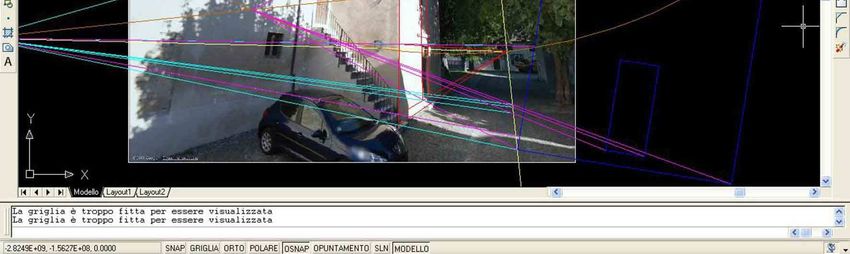
Furno – Google Street View, special data storage for Building Archaeology

a specialist in the field, they are rapid, they minimize post-capture processing and they convey domain
specific information efficiently.

Post processing phase
This phase is concerning the actual drawing, in which the most significant features of the structure’s
architecture are put into a foreground instead of the rest of the structure. It is an important phase in which the
operators introduce an "interpretation" of the data obtained during the measurement phase, although they
are moving on a real and objective vision of the photos. If the operation is carried out in a digital way, the
result must be a vectorial and metric, three-dimensional and geo-referenced drawing (space oriented on the
topographic). Restitution softwares must allow this type of procedure:
    −   render the internal orientation of each photo,
    −   render the relative orientation for the two (and other) photos,
    −   render the absolute orientation of the model that has been decided in the previous stage of relative
        orientation,
    −   render the collocation in the space on an appropriate reference system,
    −   transfer the geometric information contained in the photos in graphical and/or numerical form, on
        paper (properly so-called the phase of “restitution”).
However, even in later times, it is always possible to derive new information or verification carried out from
the photogrammetric survey, since it is a permanent recording of all the recorded architectural structure. The
survey restitution, despite the objective use of a tool such as photography, remains a critical operation and a
sort of interpretation: from photography in order to record as much information as possible, a graphical
representation of the image is required, together with the most significant elements of architecture. Indeed, it
is at this time that we proceed to the real purpose of which photogrammetry was only a half, or start
stratigraphic analysis involves the identification of the main USM (“unità statigrafica muraria”, a minimum unit
identified) and finally reaches the periodization in activities, periods, phases and events. The stratigraphic
analysis is assisted by:
    −   identification of the construction model (towers, churches, residences, fortifications, etc.);
    −   structure (load-bearing vertical and horizontal scales, etc.);
    −   construction techniques used (it was founded, floor levels, insertion of ceramic structures);
    −   presence or absence of inscriptions (which is always a great element dating);
    −   materials characteristics (type of materials used, size of individual pieces);
    −   working surface (partial or any);
    −   type of installation (characteristics of the mortar or a binder rather than another, lines of the bricks);
    −   size of quotations or bricks themselves to define a mensiocronology;
    −   finishing (plastering is common, are also traces of the tools used). (BROGIOLO 1988)
Taking into consideration all these factors (as well as other questions that arise during the study of the
product), it is possible to delineate a relative chronology of the building structure and therefore to provide
valuable support, for example, for a restoration project. In any case, this work allows you to have complete
documentation and therefore the systematic application of these methodologies in the long term: the creation

                                                                                                                     3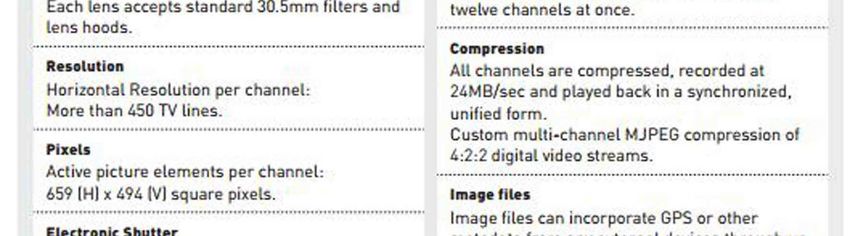
International Conference on Cultural Heritage and New Technologies | Vienna | 2012

of databases has a great interest for artistic Heritage and the use to all those involved in industry, current
and future.

Photogrammetry
Photogrammetry is both the most economical survey method available and also produces the best overall
accuracy (VALLE & RODRIGUEZ 2010). It is most effective when applied to subjects where line detail is
easily identified, such as an ashlar wall. As the final product is a CAD drawing, it can easily be edited by the
end-user, like drawings and photographs that amplify and illuminate a record. In many cases they are a more
efficient way of capturing data than either drawings or written description, but they are also valuably
supplement and to verify drawn or written records.
Historic-building records must provide information that is accessible and readily intelligible to a range of
professional, academic and lay users. In producing and curating them certain guiding principles should be
borne in mind:
    −   a record should chart the historical development of the building or site, explaining and illustrating
        what is significant and providing dates for significant parts or phases of development wherever
        possible;
    −   a record should aim to be accurate, clear and concise;
    −   the scope and level of the record and its limitations should be stated;
    −   a record should make a clear distinction between observation and interpretation, thereby allowing
        data to be reinterpreted at a later date;
    −   wherever practicable a record should take account of the site’s context, including its wider
        archaeology, known and potential, whether in terms of below-ground deposits or of landscape
        archaeology;
    −   a record should include an indication of any sources consulted;
    −   a record should identify its compilers and give the date of creation, and any subsequent
        amendments should be similarly endorsed;
    −   a record should seek to embody the benefits of peer review;
    −   the report and supporting material should be produced in a medium which can be copied easily and
        which ensures archival stability;
a record should be made accessible through deposit in a permanent archive and signposting in a recognized
internet finding aid (English Heritage 2009).

Data storage and data management of digital image
Digital image can be considered the revolution in the latest years in the field of photographic restitution
softwares. Nowadays, a main part of photogrammetry is realized with the use of digital images. The
development of still digital cameras in recent years has presented the possibility of capturing images of a
quality once obtainable only with film. While film images currently contain more information than most digital
images, and have a proven longevity, digital capture can deliver good quality provided a high-resolution
camera (with a field exceeding about five megapixels) is used. The digitalization consists in converting an

                                                                                                                       4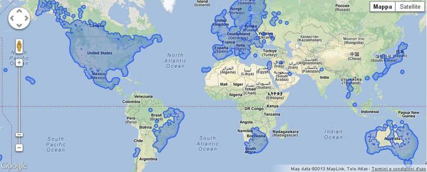
Furno – Google Street View, special data storage for Building Archaeology

analogic image in a series of graphic elements called pixel (picture element) or in other words a series of
smallest black and white squares, with specific hues in a scale of greys or colors. In a field of building
archaeology, a dimension of pixel like that with high definition image allows to distingue many details on the
surface of the stonework. On the base of these metric information, it can be possible to fix: traces of the
production on the rocks, position and dimension of the junts, measurement of the bricks, weaving of the wall
structure, types of the arches or of the other openings (windows, arches, doors). These are fundamental
data in order to obtain the guidelines for knowledge of the characteristic elements of the historical building.
Photographic pictures contain visual information about the elements together with high resolution and low
cost. They can be used metrically with different degrees of accuracy: from the dimensional analysis through
perspective of single images to photogrammetry. A photographic collection is far more than a stack of image
files stocked in a hard disk, but it is a reserve of information than can be recovered in the future. However, to
try to reach this aim, it is necessary to associate the images with some information concerning the following
aspects:

Context
Apart from the representation of the objects, the work of the photographs must register information about the
context: what is documented and why, where the image was taken, who took it and which copyrights are
attached to the image, etc. This aspect is closely related with the classification and the descriptive metadata.
Classification and recovery are powerfully interconnected: when an image is being classified we should think
about what an user in the future will try to look for and how. That is, the user will probably use a searching
point where they will introduce some keywords in order to find appropriate images. The search will be
successful only if our images are attached to this searching point and the keywords are the same we used to
classify them. The best choice is use an interconnection of data banks and the use of controlled
terminologies or thesauruses.

Radiometric
The color that we have in the images depends on the atmospheric conditions and the shooting parameters,
and, it is necessary to calibrate the radiometric response of the sensors in order to compare different
images. Furthermore, it is interesting and useful knowing the parameters of the shot, so called technical
metadata, that are normally stored in the raw images but which can disappear in its derivatives in addition
we should include reference elements in the scene.

Metric
Supplemental information is also necessary to extract metric data from the photographs: on the one hand,
the internal geometry of the camera this information can be embedded in the own images as technical
metadata (for example in Exif: exchangeable image file format for digital still cameras) or be an external file
that has to be attached. On the other hand, more than one photograph is needed to compute coordinates
(strip processing, bundle adjustment, etc.) so we will need a way to link the different images that compose
each group. Finally there will be more information, such as the location of the control points and their
coordinates that will come in separate files. All in all photographs cannot be considered by its group and also
with external files like a certificate of calibration, a sketch with the position of the control points and a list with
the coordinates of these points.

                                                                                                                          5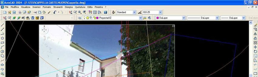
International Conference on Cultural Heritage and New Technologies | Vienna | 2012

It is essential to save the raw files because they contain all the information obtained by the cameras and
technical metadata. Raw files are proprietary formats of each company, so they are unsuitable for data
preservation. One interesting alternative is the format DNG (Digital NeGative) (ADOBE 2012), developed
and supported by Adobe®; although it is not a standard, it is widely used and its specifications are published
and can be openly accessed. After one year of its introduction, numerous companies like Extensis, Canto,
Apple, iView have developed the same file than can be read the DNG. Furthermore, well know companies
like Hasselblad, Leica, Casio, Ricoh and Samsung have introduced in the market the new cameras with the
direct DNG support. Next, context must be added, we can use the IPTC (International Press
Telecommunications Council) (IPTC 2012) metadata schema, if possible with controlled vocabularies.
These images will be our masters that we will preserve carefully and from which we will derive new images
for specific purposes such as metric use, advertising, etc. These new images will have different features:
resolution, metadata, file format and so forth, depending on the purpose and the software where they will be
used. We also need to link the files with their additional information (calibration, coordinates, etc.) which is
seldom done by the software to manage photographs. There are some alternatives, either using a general
purpose database or wrapping the data with a multilevel code (EAD, METS,…) or build up a brand-new
system (for example a multimedia based on HTML). In order to maintain a collection at our disposal without
difficulties, it is necessary cover two features: physical and format. As regards the first feature, the
information will not be lost due to degradation of the carrier where it is registered. This trouble can be
avoided by means of backup copies stored separately, refreshment to new carriers every accorded time. As
regards the second feature, in the future there will be software able to recognize the file format and use it
with all its capabilities. The use of standards is obligatory to fulfill this aim. Nevertheless, every format
becomes obsolete in a few years, so migration should be considered which could be problematic if we are
considering not only single image files, but also their metadata and links (VALLE & RODRIGUEZ 2010).

Google’s tool: “Google Street View”
Google Street View is an innovative technology featured in Google Maps and Google Earth that provides
panoramic views from positions along many streets in the world. This type of technology provides panoramic
views at 360° horizontally and at 290° vertically of the streets, similar to what you see while walking or
driving along those same streets. Google Street View was introduced in the United States on 2007 (Denver,
Las Vegas, New York, Miami and San Francisco) and until July 2008 it covered areas of the United States.
By 2009, United Kingdom started off on Google Street View with numerous cities like London, Belfast,
Cambridge, Edinburgh and Glasgow. Now service is available not only in the United States, but also in
Europe and in other countries: the service coverage is frequently updated on the official site (GOOGLE
STREET VIEW 2013) (Fig. 1). Google Street View was introduced in Italy in October 2008, adding the main
cities like Rome, Milan and Florence, but lately the coverage has been reached on all the Italian territory.
These images were taken, using special cameras and other special equipment that can obtain images
connected with specific locations through GPS system.

                                                                                                                        6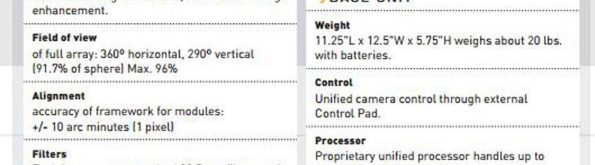
Furno – Google Street View, special data storage for Building Archaeology

Fig. 1 – Google Street View coverage (Copyright: Google)

After the acquisition, the images are “glued” with one another in order to create a panoramic view at 360°.
The cameras were collocated on the sunroof of the cars, so called “Google Cars”, but in pedestrian areas
(for example the inner cities), gardens, university campus and dirty tracks Google Trike, a pedal tricycle with
a 4th generation camera were used in order to take images where cars cannot reach. The ensuite camera is
a Dodeca 2360 System, with eleven lenses that capture images with high resolution at 360°, from every
direction, simultaneously at more than 100 million pixels per second (or 30 frames per second). It is very light
and compact (weights 11 kg) and it can be positioned on moving vehicles or adapted to every application, for
example on cyclist’s backpacks. The IM system is based on the dodecahedron, a sphere with twelve faces.
The Dodeca system enlarges the frames that were captured by every lens, then it makes a mosaic of every
frame and finally it produces a large frame of all the surrounding environment (Fig. 2-3) (DODECA SYSTEM
2013).

Fig. 2 – Dodeca 2360                                  Fig. 3 – Technical Specifications Dodeca 2360 from
                                                       http://immersivemedia.com/wp-content/uploads/2012/03/imc_cs_Dodeca-2.pdf

                                                                                                                                  7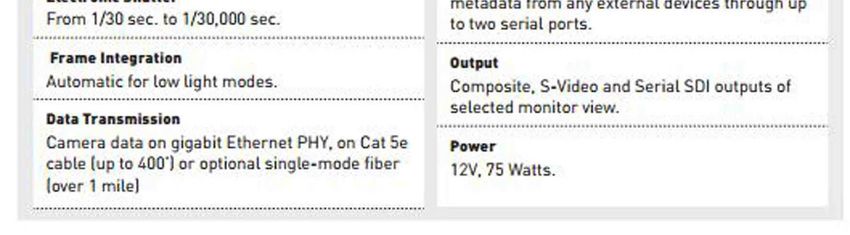
International Conference on Cultural Heritage and New Technologies | Vienna | 2012
Where the service is available, Street View images appear after zooming in beyond the highest zooming
level in maps and satellite images, and also by dragging a "pegman" icon into a location on a map. When
dragging the pegman icon, blue lines on the map showing Street View imagery will appear: using the mouse
the horizontal and vertical viewing direction and zoom level can be selected. A solid or broken line in the
photo shows the approximate path followed by the camera car, and arrows link to the next photo in each
direction. At junctions and crossings of camera car routes, more arrows are shown. By using Google Maps,
users can turn on stereoscopic 3D mode by right-clicking in Street View to get an anaglafyc version of any
Street View images.
Google operators created, inadvertently, unique and exceptional data storage of images. This type of work
can be considered great substance for any type of uses. It is a data storage from which information and
elements useful for building’s archeology, like stratigraphic interpretation of the walls can be obtained. For
example, in the specific case of an earthquake or any catastrophic event, Google storage has the
registration of all information, and it can be a useful help in order to know all formal, material and
dimensional features. Without the storage, the information would be lost (except for previous available
documentation). The photos with this type of camera are undoubtedly images with high resolution and they
own technical metadata than can define metric data, and consequently it can be used for a photogrammetric
project. At this point, it is necessary to clarify that it is possible to use the screenshots of Google Street View,
but this type of photo had been modified by during the upload process and the mosaicking process in order
to adapt it to the browser, so in the end it loses its high resolution. On the other hand, Google owns every
original photo together with the raw files, which contains all metadata necessaries to know technical
information. It wasn't possible to gain access to the original catalogue in Mountain View (California), because
the service preserves users' privacy. Privacy is an issue that came across in the case of online consultation,
which gave life to a large sue in 2007. Google Street View has indeed a high level of detail in pictures, so it
makes possible to identify people and number plates.
Case Study: Modeling 3D Ss. Stefano e Silvestro Church
Preliminary situation
At this point, we can confirm that Google Street View images are good resources to enter in a digital storage
that could give an unlimited number of information. On these bases, we attempted to reconstruct a 3D model
of SS. Stefano e Silvestro Church, in the small town of Castelnuovo (L’Aquila-Italy) in the district of San Pio
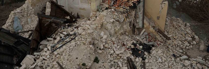
delle Camere, which was completely destroyed by the April 2009 earthquake. (Fig. 4).
8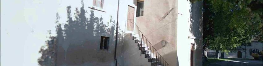
Furno – Google Street View, special data storage for Building Archaeology
Fig. 4 – Ss. Stefano e Silvestro Church after the earthquake, April 2009
Methodology
The procedure of a 3D model construction is divided in two main parts: the first part of the project consist of
drawing the geometric solid (so-called wireframe) of the structure and the second part is the texture
rendering. In the phase of planning, the main necessity is to obtain a project compatible with the final
product, which must be subjected to the data’s fruition. In this project we can see only the first part of the
drawing, because Google Street View pictures are in lower resolution and the pictures’ quality deals with a
further loss of resolution after the process of geometrical correction. With this level of resolution, it is
impossible to complete a wireframe with suitable texture. The amazing aspect of the part of the project is the
fact that the pictures can give metric information in order to reconstruct the building wireframe. In order to
rebuild the wireframe, we use two types of methodological approaches: 1.Measurements on ortophotos 2.
Inverse prospective method.
Given data
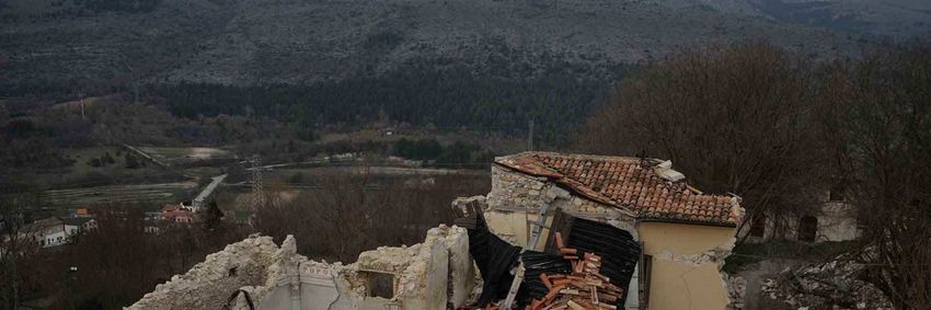
The elements at our disposal are only the images from Google Street View, taken before the quake (Fig. 5-6)
and topographical points taken by a total station, after the quake. It is noted that the topographical points are
in a .txt file and the images are screenshots, not the original copies. I deduced the plan of the church from
the topographical points, using AutoCAD tool (Fig. 7).
9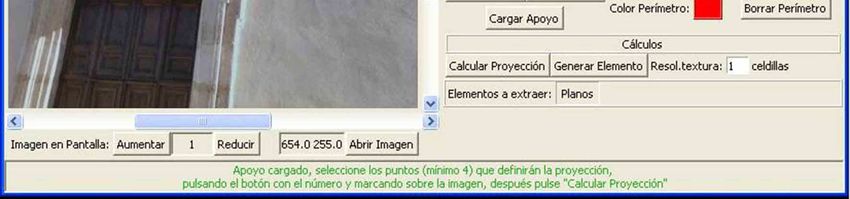
International Conference on Cultural Heritage and New Technologies | Vienna | 2012

Fig. 5 – Façade from Google Street View (Copyright: Google)

Fig. 6 – Southern façade and bell tower (before geometric correction) from Google Street View (Copyright:Google)

                                                                                                                            10
Furno – Google Street View, special data storage for Building Archaeology
First method: Measurement on orthophotos
It is necessary to have two photos of the building with minimum metric information in order to apply this
method. As discussed previously, Google Street View images are screenshots from internet with low
resolution and therefore do not give us any metric information. In order to overcome this lack of information,
we resort to the use of the plan of the church (Fig.7), which was deduced from the topographical points taken
with the total station after the earthquake.
Fig. 7 – Plant of the church deduced from the topographical points
Using AutoCAD tool, we can insert the pictures that show the southern façade (the image where the bell
tower is represented), and at this point the image is scaled according to the distance known from the survey.
In this case, what we know is just the distance from point 1 to point 2 (Fig. 8).
This distance the scale of the whole image and consequently of the complete 3D model. On the other hand,
the frontal façade and the bell tower in the pictures don’t have a complete view. For this type of pictures
(without frontal view) it is necessary to use a photogrammetry’s software. In my project, I used open source
software called Modelado, (EHU, 2013) that can upload the picture and at the same time the text file that
contains the topographical points. In the same main screen of Modelado, (Fig. 9) it is possible to indicatively
pinpoint the topographical points on the picture and in this way to calculate the final product
11International Conference on Cultural Heritage and New Technologies | Vienna | 2012
Fig. 8 – The distance from point 1 to point 2
Fig. 9 – Screenshot from Modelado software
After the process of rectifying, the picture can be inserted in AutoCAD with the same scale system of the
south façade, scale based on the church’s plan. At this point, not only the resolution changes, but also the
dimension loses several inches compared to the original. This approach doesn’t have extreme precision, and
12Furno – Google Street View, special data storage for Building Archaeology
in the final phase, in which the whole model is scaled metrically, will not be perfect. We proceed in the same
way for two façades of the bell tower: rectify the picture and after that we can scale it, based on
measurements in common with the pictures before scaled. After we have taken all the measurements, we
can be inserted church’s plan in AutoCAD, calculated from topographical points; now it is possible insert all
the coordinates (x, y, z) of the distances measured on each reference photo scaled above.
Fig. 10 – The distance from point 1 to point 3
For example: in order to reconstruct the line from the point 1-3,(Fig. 10) we can insert as point coordinates 1
(x, y, z) that we know thanks to the distance 1-2, then the coordinates of point 3, also thanks to a distance
that we know. It has to be considered that each reconstructed line has to be reconstructed using a reference
line on the same plane. The upper part of the south façade, for example is not located on the same plane of
the measure derived from the plane in which the lower part has been scaled. Therefore a new reference line
derived from the plant has to be defined.
Second method: Inverse perspective method
The chapel (located on the south side of the church) was reconstructed using inverse perspective method
(Fig.11).
It is a geometrical method used for various purposes, for example when taking photos with a wrong and
distorted perspective. In this case, it is necessary remove the effect of the “linee cadenti” with the use of
optical methods. Variations of optical flow can be due to both, perspective foreshortening and the 3D
13International Conference on Cultural Heritage and New Technologies | Vienna | 2012
structure of the scene. Since we are only interested in the latter part, the presence of elevated points we
could try to eliminate the effects of perspective by means of a coordinate transform.
Fig. 11 – The chapel (before rectifying process) from Google Street View
Figure 12 shows how this can be done: if we consider a point p in 3D space, perspective mapping means
that we draw a line through this point and the center of projection N and intersect it with the image plane to
find the corresponding image point. In order to remove the distortions of the horizontal plane, we now want to
undo this perspective map for points in the plane. We therefore define an “inverse perspective” by the
following procedure: for a point p’ in the image plane, we trace the associated ray through N towards the
horizontal plane. The intersection is the result of the inverse perspective applied to the image point p’. The
term 'inverse perspective mapping' does not correspond to an actual inversion of perspective which is of
course mathematically impossible.
Rather, it denotes an inversion under the additional constraint that inversely mapped points should lie in the
horizontal plane. If we compose both perspective and inverse perspective, the horizontal plane is mapped
onto itself, while elevated parts of the scene are distorted. The figure shows the results using this method
(screenshot from AutoCAD tool (Fig. 13).
14Furno – Google Street View, special data storage for Building Archaeology
Fig. 12 – Geometry of perspective mapping. N: center of projection (nodal point), y', z' axes of the camera coordinate system, y, z axes
of the world coordinate systems. The horizontal axes x' (for the camera) and x (for the world system) are perpendicular to the paper
plane and are omitted in the figure, p: a point in 3D space; p1, p h: its projections into the image and the horizontal plane; j:
homogeneous representation of p'. f is the focal length of the camera system and h the height of the camera nodal point above the
ground plane. By φ, we denote the inclination angle of the optical axis, i.e., the angle between y and z'
Fig. 13 – Screenshot from Autocad tool
15International Conference on Cultural Heritage and New Technologies | Vienna | 2012
Conclusions
Photographic collections are a very interesting product for Cultural Heritage knowledge. Nevertheless, to be
really effective they should follow some guidelines for the preparation, capture, storage and classification.
The alternatives are various, and it depends on the purpose of the projects. Anyway, we must keep the
context of the images and ensure the future utilization as metric documents and radiometric reference. We
don’t have single and perfect method in order to have a 3D model, but this online storage is an excellent
starting point. These two approaches are only two of two methods among a large variety of solutions that
can be used. A perfect method does not exist, but we can underline that the perspective method is more
accurate than the first. In fact, in the first method, the scale was repeatedly applied, and it depended on
subjective measurements taken by Google Street View’s image, that owns no metric information and no high
resolution. Furthermore, the measurement results are not metrically perfect because the pictures after the
process of rectifying have lost 10 centimeters compared to the original pictures. On the other hand, using
perspective inverse method, the plan is inserted in AutoCAD in the final phase and above all the pictures
don’t need the process of rectifying. If the resolution of the photo had been higher, the 3D model could be
completed by inserting the texture, which in this case is a low resolution in order to be inserted in the
wireframe (the final result is showed in the Figure 14).
Fig. 14 – Final Result: Wireframe of the church
As for the Google Street View storage, any collection of photographs is valuable in order to achieve
functional information for any type of project. In this context, we can note the importance of cataloguing all
16Furno – Google Street View, special data storage for Building Archaeology the data that we have, in order to be able to not only to allow easy access to future user, but also to pay attention to the file cataloguing method in order to be able to use them in the future. References ANDREWS, D., BEDFORD, J., BLAKE, B., BRYAN, P. . (2009). “Techniques and practice for the metric survey of historic buildings”. In: Bedford, J, Papworth, H. Measured and Draw. England: English Heritage. 1-20. ADOBE (2012) Digital Negative (DNG) [online] available from [February 2013] BROGIOLO, G.P. (1988) Archeologia dell’edilizia storica. Como: Edizioni New Press DODECA (2013) Dodeca 2360 Camera System [online] available from http://immersivemedia.com/wp- content/uploads/2012/03/imc_cs_Dodeca-2.pdf [February 2013] EHU (2013) Modelado Software [online] available from http:www.ehu.es/docarq/LDA/programas/Modelo_gen/index.htm [February 2013] EXIF (2012) Exif Version available from [April 2012] GOOGLE STREET VIEW (2013) Google Street View Official Site [online] available from http://maps.google.it/help/maps/streetview/ [February 2013] IPTC (2012) IPTC Standard v.1.1 Photo Metadata available from [April 2012] VALLE, J.M, RODRIGUEZ, A., (2010) “Methodological keys for the acquisition and long-term use of photographic collections representing elements of Heritage”, in Melero, F.J., Cano, P., Revelles, J., (ed.) Fusion of culture. Abstracts of the XXXVIII conference on Computer Application and quantitative methods in Archaeology, held 6-9 April 2010, Granada, 175-178. Imprint: Proceedings of the 17th International Conference on Cultural Heritage and New Technologies 2012 (CHNT 17, 2012) Vienna 2013 http://www.chnt.at/proceedings-chnt-17/ ISBN 978-3-200-03281-1 Editor/Publisher: Museen der Stadt Wien – Stadtarchäologie Editorial Team: Wolfgang Börner, Susanne Uhlirz The editor’s office is not responsible for the linguistic correctness of the manuscripts. Authors are responsible for the contents and copyrights of the illustrations/photographs. . 17
You can also read