National Report of Sweden to the EUREF 2021 Symposium
←
→
Page content transcription
If your browser does not render page correctly, please read the page content below
2021-05-12
T. KEMPE, A. ALFREDSSON, S. ALISSA, A. ENGFELDT, F. DAHLSTRÖM, M. HÅKANSSON,
    L. JIVALL, L. JÄMTNÄS, M. LIDBERG, T. NING, D. NORIN, P-A. OLSSON, H. STEFFEN,
                                                 R. STEFFEN, P. WIKLUND, J. ÅGREN

NATIONAL REPORT

National Report of Sweden to the
EUREF 2021 Symposium
– Geodetic Activities at Lantmäteriet

       1. Introduction
Lantmäteriet, the Swedish mapping, cadastral and land registration autho-
rity, is responsible for the national geodetic infrastructure. The geodetic
work is based on the new geodetic strategic plan presented late 2018 (Lant-
mäteriet, 2018). The activities in the fields of geodetic reference frames and
positioning are focused on
•     the operation, development and services of Swepos™, the Swedish
      national network of permanent reference stations for GNSS
•     contributions of Swepos data to international initiatives such as EPN,
      EPOS and IGS as well as international analyses of GNSS data
•     the implementation and sustainability of the Swedish national reference
      frame SWEREF 99 and the national height system RH 2000 (ETRS89
      and EVRS realisations respectively)
•     improvements of Swedish geoid models and renovation of the gravity
      network.
Sweden, through Lantmäteriet, is since 2018 member of the UNGGIM
SCoG and is also leading its working group on Education, Training and
Capacity Building.

       2. Contributions from Lantmäteriet to EPN
The number of Swepos stations included in EPN is 27. Seven of the original
Swepos stations have been included since the very beginning of EPN. These
stations are Onsala, Mårtsbo, Visby, Borås, Skellefteå, Vilhelmina and
Kiruna (ONSA, MAR6, VIS0, SPT0, SKE0, VIL0 and KIR0). The other 20
stations are represented by an additional monument located at the original
Swepos stations. Daily and hourly data are delivered for all stations, while
real-time data are delivered from nine stations.
Lantmäteriet operates the NKG EPN AC in cooperation with Onsala Space
Observatory. The NKG AC contributes with weekly and daily solutions,
since November 2019 based on CODE rapid products, using the Bernese
GNSS Software. The EPN sub-network processed by the NKG AC consists
of 100 reference stations (May 2021) concentrated to northern Europe.

    Lantmäteriet, PHONE +46 (0)771 636363 E-MAIL lantmateriet@lm.se WEBSITE www.lantmateriet.se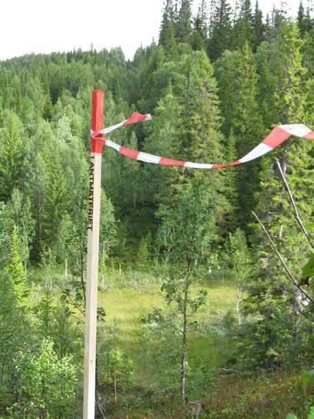
3. EPN Related GNSS Analysis
The NKG GNSS AC is chaired by Lantmäteriet (Lahtinen et al., 2018). The
project aims at a dense velocity field in the Nordic and Baltic area. Consis-
tent and combined solutions are produced based on national processing
using the Bernese GNSS Software version 5.2, following the EPN analysis
guidelines. The reprocessing of the full NKG network including all Nordic
and Baltic countries, covering the years 1997–2016 with a processing setup
consistent with EPN Repro2, (Lahtinen et al., 2019) has been followed up
with an updated coordinate and velocity solution including also operational
data up to 2020.5. The weekly solutions from the reprocessing and the con-
tinued operational solutions contribute to the EPN densification project on a
regular basis.
Lantmäteriet is one of the analysis centres in E-GVAP, as the Nordic GNSS
Analysis Centre (NGAA), and undertook the data processing for approxima-
tely 750 GNSS stations mainly in Sweden, Finland, Norway, Denmark
(Lindskog et al., 2017). Two near-real-time (NRT) ZTD products, i.e.,
NGA1 and NGA2, are currently provided. Both products are obtained from
the Bernese GNSS Software ver. 5.2 using a network solution. The NGA1
product is updated every hour while the NGA2 product is updated every 15
minutes.

    4. Swepos – the National Network of Permanent
       Reference Stations for GNSS
Swepos™ is the Swedish national network of permanent GNSS stations
operated by Lantmäteriet; see the Swepos website, https://www.swepos.se.
The purposes of Swepos are
•   providing single- and dual-frequency data for relative GNSS
    measurements
•   providing DGNSS corrections and RTK data for distribution to real-time
    users
•   acting as the continuously monitored foundation of SWEREF 99
•   providing data for geophysical research and for meteorological
    applications
•   monitoring the integrity of the GNSS systems.
By May 2021 Swepos consisted of totally 458 stations, of which 53 are of a
higher class, the so-called class A, and the remaining 405 stations are of
class B, see Figure 1. This means that the total number of Swepos stations
has increased with 37 stations since the EUREF Symposium in 2019.

                                                                         2(18)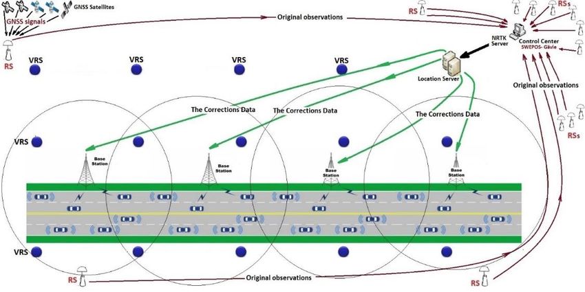
Figure 1: Left: Sveg is one of the Swepos class A stations. It has an old monument (established in
1993) as well as an additional monument (2011). Right: Gustavsberg is a Swepos class B station with
a roof mounted GNSS antenna established mainly for network RTK purposes.

The class A stations are monumented on bedrock and have redundant equip-
ment for GNSS observations, communications, power supply etc. Class B
stations are mainly established on top of buildings for network RTK purpo-
ses. They have the same instrumentation as the class A stations (dual-
frequency multi-GNSS receivers with choke ring antennas), but with some-
what less redundancy.
Five of the original 21 Swepos stations (Onsala, Mårtsbo, Visby, Borås and
Kiruna) are included in the IGS network, as well as three of the additional
monuments with newer steel grid masts (ONS1, MAR7 and KIR8).

    5. Swepos Services
Swepos provides real-time services of metre level uncertainty (DGNSS) and
centimetre level uncertainty (Network RTK), as well as data for post-
processing in RINEX format. A transition from RINEX 2 to RINEX 3 has
been implemented during the last years. An automated post-processing
service, based on the Bernese GNSS Software, is also available.
Since data from permanent GNSS stations are exchanged between the Nor-
dic countries, good coverage of the Network RTK service has been obtained
in border areas and along the coasts. Several stations from SATREF in Nor-
way and the Danish Agency for Data Supply and Efficiency are included
together with stations from private operators in Norway, Denmark, and
Finland as well as Sweden.
The Network RTK service has, in May 2021, approximately 7285 subscrip-
tions, which means some 2800 additional users since the EUREF Sympo-
sium in 2019. Lantmäteriet also has cooperation agreements with seven
international GNSS service providers using data from Swepos stations for
their services. This is done to increase the use of Swepos data as well as
optimising the benefits of the geodetic infrastructure.

                                                                                              3(18)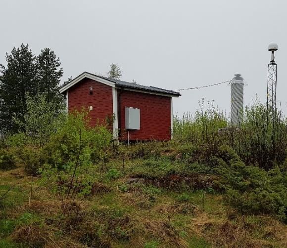
The real-time services utilise Trimble Pivot Platform GNSS Infrastructure
Software and are operating in virtual reference station mode. The Network
RTK service distributes data for GPS, Glonass and Galileo as well as GPS
L5 and L2C signals using RTCM MSM. The plan is to include BeiDou
during 2021.
There is an increasing demand for uninterrupted availability of the real-time
services, from current applications (e.g. agriculture) as well as future appli-
cations (e.g. autonomous vehicles). To meet these demands, a redundant
server infrastructure has been established in a separate physical location – a
so-called High Availability solution. This second data centre became opera-
tional in October 2020 and will protect against e.g. loss of electricity or
Internet connectivity. During normal operation, the Network RTK users are
distributed between both data centres, but in case of a failure at one data
centre, the other data centre has the capacity to handle all users. This system
will also facilitate system maintenance since all traffic can be redirected to
the other location while e.g. updating is done.

   6. Reference Frame Management – SWEREF 99
SWEREF 99 was adopted by EUREF as the Swedish realisation of ETRS89
in 2000 (Jivall & Lidberg, 2000) and is used as the national geodetic refe-
rence frame since 2007.
By defining SWEREF 99 as an active reference frame we are exposed to
rely on the positioning services of Swepos, like the Network RTK service.
All alterations of equipment and software as well as movements at the refe-
rence stations will in the end affect the coordinates. To be able to check all
these alterations, approximately 300 nationally distributed passive so-called
consolidation points are used. Each year, 50 of them are remeasured with
static GNSS following a yearly programme.
Since the original SWEREF 99 campaign, the coordinates of the Swepos
stations (see chapter 4) have been updated when necessary, e.g. when GNSS
antennas were exchanged and when new antenna models and computation
strategies have been introduced. Corrections have been added in a cumula-
tive way and stations have been determined in different epochs partly using
different models of post-glacial deformation, leading to an increase of the
uncertainties between stations.
Therefore, a review of the frame was undertaken during 2020 and updated
coordinates were implemented in the Swepos services in the beginning of
2021. The new coordinates are based on GNSS-data from the autumn 2019
and the NKG_RF17vel land uplift model.
The purpose of the review and coordinate update was to achieve a more
homogeneous SWEREF 99 that will be sustainable for the future. An over-
all measure has been taken to obtain a reference system that is consistent
with today’s measurements and computations.

                                                                           4(18)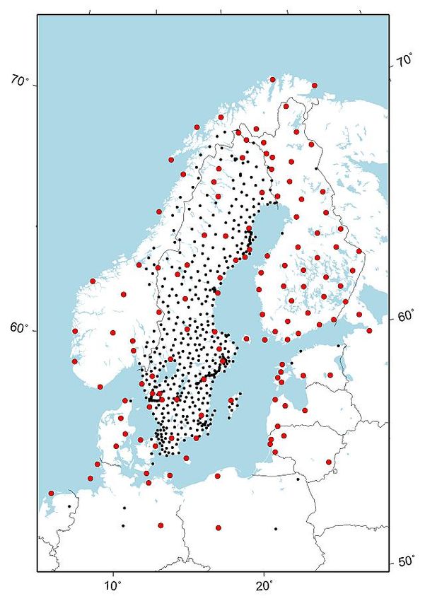
The number of reference frame      Figure 2: Red dots show the defining stations of the
                                   SWEREF 99 updating campaign. The other stations in
defining stations increased with   the campaign are shown in black.
the update, to some thirty
stations in Sweden and, in
addition, approximately
100 stations in our neighbou-
ring countries (Jivall & Lilje,
2021). The number of foreign
defining stations will however
decrease with time, since there
is no ambition to determine all
foreign stations anew when
they are altered.
The differences between the
previous and the updated coor-
dinates are, on the whole,
small and lies within the speci-
fications of the Swepos ser-
vices.
A new set of transformation
parameters between ITRF2014
and SWEREF 99 has been
developed in cooperation with-
in the Nordic Geodetic Com-
mission. It is available at Lantmäteriet’s web site and in the PROJ trans-
formation library, starting from version 7.2.1. The transformation is based
on the concept in (Häkli et al. 2016) and the NKG_RF17vel land uplift
model.

   7. Maintenance of the National Levelling Network
The third precise levelling of the mainland of Sweden lasted 1979-2003,
resulting in the new national height system RH 2000 in 2005 (Ågren et al.,
2007).
Our assessment is that RH 2000 will be the national height system for many
years to come and that it will be based on levelling. The reason is that the
precision of height determination with GNSS (height above the ellipsoid) is
not as accurate as the levelling technique. Therefore, the maintenance of the
height control network needs to be continued for the foreseeable future.
Since the beginning of the 1990s, a systematic inventory and updating of the
network has continuously been performed, with replacement of the majority
of destroyed points. To reduce costs – based on the fact that benchmarks
founded in bedrock and nodal points – are more valuable for the perseve-
rance of the network, new criteria for replacing destroyed points were intro-
duced in 2010. With that new approach almost none of the destroyed points
were replaced. During 2018 a review of the reduced updating programme

                                                                                   5(18)
was performed (Alfredsson et al. 2019), leading to an adjustment of the
replacement criteria, to make sure that a sufficient number of destroyed
benchmarks are replaced to secure the sustainability of the network.
When new height benchmarks are demarcated to replace destroyed bench-
marks, the levelling of them is done through procurement procedures, which
is also the situation for the re-measurements of the 300 consolidation points
described in chapter 6.
8. Geoid Determination
According to Lantmäteriet’s strategic plan (Lantmäteriet, 2018), an impor-
tant goal is to compute a seamless geoid model of high accuracy that fulfils
the needs of users both on land and at sea. Many activities are going on to
realise this. A new gravity reference system/frame RG 2000 was finalised in
2019 (see chapter 9). New Swedish detail gravity observations are conti-
nuously being collected using Scintrex CG5 with the purpose to fill gaps or
replace old data of low quality.
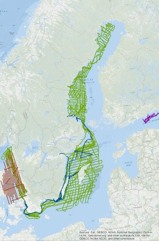
An important activity has been to Figure 3: Marine gravity campaigns performed
by Lantmäteriet during 2017-2020.
improve gravity and geoid in the
Baltic Sea within the project
FAMOS, which we can also benefit
from on land, mainly in the coastal
areas.
The introduction of the common
BSCD2000 (Baltic Sea Chart Datum
2000) (EVRS with land uplift epoch
2000.0) in the Baltic Sea (Schwabe
et al., 2020) improves navigation and
hydrographic surveying with GNSS-
based methods and a geoid model in
the Baltic Sea plays an important
part here. The FAMOS geoid will
realise BSCD2000 in the Baltic sea
and connect to the EVRS realisations
on land. Unfortunately, the EU fun-
ding for FAMOS was interrupted
earlier than planned in June 2019,
but the work now continues under
the umbrella of the Chart Datum
Working Group of the Baltic Sea Hydrographic Commission.
During 2019-2020, eight large dedicated marine campaigns were observed
with Lantmäteriet’s ZLS marine gravimeter. Gravity data has been delivered
to the FAMOS database together with all data collected by the other partici-
pating countries/organizations around the Baltic Sea. The final FAMOS
geoid model is planned to be finalised and released in 2022.
6(18)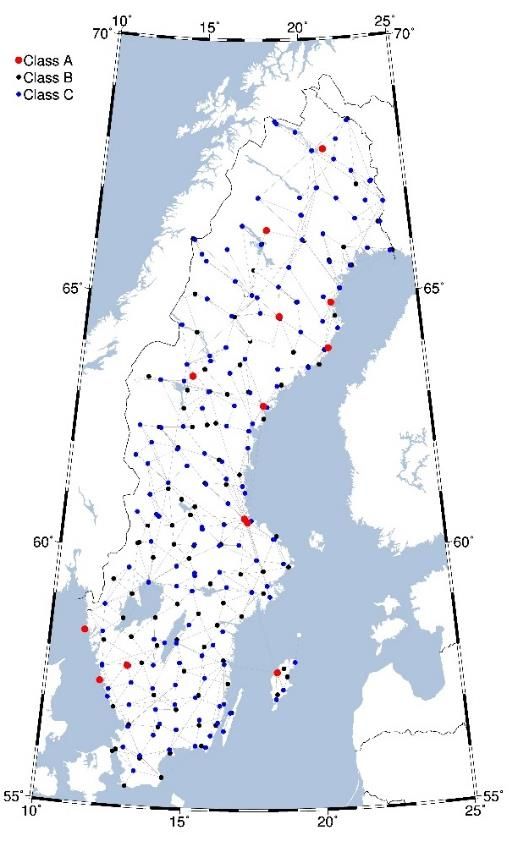
In the last years, much work has been spent on improving and densifying
the Swedish national GNSS/levelling dataset. The core of the new, updated
dataset is the so-called SWEREF GNSS points for which accurate levelled
heights are available in RH 2000. A majority of these SWEREF points are
also consolidation points (see chapter 6), which are redetermined every six
years. This makes it possible to detect and remove unstable points. Since
2019, the levelled normal heights of the GNSS/levelling points are also
checked by relevelling relative to the benchmarks in the national precise
levelling network.
In 2020, an industrial PhD student was initiated at the University of Gävle
in cooperation with Lantmäteriet. The main aim of this PhD project is to
develop and investigate different methods for regional realisation of the
International Height Reference System (IHRS) in Sweden and the Nordic/
Baltic countries.

   9. Gravity Activities
In Sweden 13 stations (see        Figure 4: The 13 absolute gravity stations (for FG5) in
                                  Sweden (blue dots) with the land uplift model
Figure 4) are revisited with      NKG2016LU_gdot, which shows the annual gravity
Lantmäteriet’s absolute           change [µGal yr-1].
gravimeter, FG5X-233, with
an interval of approximately
one to three years. Since
2007, FGX-233 also regularly
participates in local, regional
and international AG inter-
comparisons in order to keep
track of possible systematic
biases.
All Swedish absolute gravity
sites for FG5 are co-located
with Swepos stations. Ratan,
Skellefteå, Smögen, Visby
and Onsala are co-located
with tide gauges. Onsala is
also co-located with VLBI
telescopes and a super-
conducting gravimeter, which is annually calibrated with FG5X-233 AG
observations.
In the beginning of 2018 the new Swedish gravity reference frame,
RG 2000, became official (Engfeldt et al., 2019). The reference level is as
obtained by absolute gravity observations according to international stan-
dards and conventions. It is a zero permanent tide system in post glacial re-
bound epoch 2000. RG 2000 is realised by the 13 FG5 stations mentioned
above, 96 A10 points (measured by IGiK) and some 200 points observed
with relative gravimeters; see Figure 5.

                                                                                       7(18)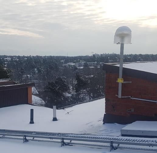
During the last year, all Lantmäteriet’s           Figure 5: Reference points in RG 2000
                                                   (class A, B, C).
detail gravity observations have got a
gravity value in RG 2000. The about
4000 detail gravity observations measu-
red from 2010 and later have got their
gravity value without any transforma-
tion. The other about 22000 detail gra-
vity observations are transformed from
their original gravity system, RG 62 or
RG 82. It should also be mentioned that
in connection to the transformation,
more than 1000 bad detail gravity
observations were removed from the
gravity database.

    10. Geodynamics
The land uplift model NKG2016LU
was released in 2016. It is a combina-
tion of levelling and GNSS data with a
GIA model. Reliable uncertainty esti-
mates have been introduced that con-
sider both measurement and GIA model
uncertainties. A description of the model can be found in Vestøl et al.
(2019).
The GNSS data of NKG2016LU are based on the latest BIFROST effort,
i.e. research regarding the 3D geometric deformation in Fennoscandia and
adjacent areas; see        Figure 6: Figure 10 of Kierulf et al. (2021). BIFROST2015 velocity
Figure 6. A repro-         field after elastic correction of the vertical component and trans-
cessed velocity field      formation to the reference frame given by the glacial isostatic
                           adjustment process.
based on 164 stations
using the GAMIT/
GLOBK software has
been published in
Kierulf et al. (2021)
and contains a detailed
analysis of different
geodynamic processes
that generate the 3D
velocity field in
northern Europe, such
as elastic contributions
(due to non-tidal ocean
loading, atmospheric
loading, glacier melt in
Antarctica, Greenland
and mountain glaciers,
hydrology), GIA, sedi-

                                                                                           8(18)
mentation, reservoir changes etc. The next reprocessing, BIFROST2020,
has meanwhile been initiated which will largely extend the number of
stations (300+) and observation time span.
The new 3D velocity model NKG_RF17vel for northern Europe has been
released in 2019. The uplift part is based on NKG2016LU while the hori-
zontal motions are generated from an updated four-layer GIA model that
reduces the misfit in the horizontals. This GIA model includes a sub-
lithospheric high-viscosity layer. A detailed documentation is currently in
progress.
Lantmäteriet is involved in the EUREF effort on obtaining a high-resolution
velocity model for Europe and adjacent areas. The first EUREF velocity
model is presented at EUREF21 (Steffen et al., 2021a) based on a least-
squares collocation method with moving variance and taking plate bounda-
ries into account. The densified EPND2100 velocity field (https://epnd.sgo-
penc.hu/) was used as input.
Another major activity is the generation of the strain-rate product within
EPOS. The project is now in the pre-operational phase. Lantmäteriet has
produced the first, though preliminary strain-rate grid for Europe (Lantmäte-
riet, 2021) which can be downloaded from the product portal at
https://gnssproducts.epos.ubi.pt.
Lantmäteriet further contributes with GIA modelling studies in different
fields. Latest results include coastal ridge pattern analysis in Estonia (Suur-
saar et al., 2019), a potential glacially triggered earthquake in Greenland
with corresponding tsunami in the North Atlantic (Steffen et al., 2020), 3D
GIA model uncertainties for North America (Li et al., 2020), and the identi-
fication of a glacially induced fault in Germany (Müller et al., 2020). Lant-
mäteriet further contributed to the generation of the International Database
of Glacially Induced Faults (Munier et al., 2020) and a book on glacially
triggered faulting (Steffen et al., 2021b).
11. Geodetic SAR and InSAR
During 2019-2021 Lantmäteriet participated in the ESA founded project
Geodetic SAR for Baltic Height System Unification, led by the Technical
University of Munich (Gruber et al., 2020). The main goal of the project
was to investigate the possibility to connect tide gauges and national height
systems around the Baltic Sea by means of absolute positioning by SAR,
using active transponders. Three active transponders were installed in Swe-
den at the Swepos stations Mårtsbo, Kobben and Vinberget and they are
now fully operational. Lantmäteriet also contributed to the project with high
resolution geoid modelling at tide gauges.
Another SAR related project is the introduction of a nationwide ground
motion service for Sweden (2020-2022). This project is coordinated by the
Swedish National Space Agency and the service will be based on the same
platform as InSAR Norway (https://insar.ngu.no/). Within this project the
geodetic infrastructure in Sweden will be complemented with some 20 pas-
9(18)sive corner reflectors, co-located with Swepos stations. Lantmäteriet will
also participate in an activity related to atmospheric corrections of the
signals from the satellites.
12. Other Activities
12.1. Guidelines for Mapping and Surveying
The regulatory documents for Lantmäteriet states that one of its responsi-
bilities is to contribute to efficient and standardised surveying and mapping
in Sweden. One of the means to accomplish this is through a series of best-
practice guidelines called HMK (a Swedish acronym roughly translated as
“Guidelines for mapping and surveying”). HMK covers a wide variety of
methods for geodata capture (e.g. laser scanning, aerial photography, geode-
tic surveying) as well as more general information about quality parameters
and how they should be specified. The guidelines are reviewed by a stake-
holder reference group on an annual basis and are published as new versions
in case of major revisions. Several guidelines for geodetic applications were
updated during 2020, e.g.
• Swedish geodetic infrastructure
• Control surveying
• Terrestrial detail surveying
• RTK detail surveying
• Support for geodetic survey tenders
All HMK guidelines are published online at
https://www.lantmateriet.se/hmk, free of charge. The guidelines are also
supplemented by online courses and technical literature that cover topics
related to HMK more in-depth.
12.2. Review of the National Border with Norway
The national borders with Finland and Norway are reviewed approximately
every 25 years, as bilateral cooperation. During 2020-2024, the border with
Norway will be reviewed. The Swedish Government has appointed a so-
called border commission at Lantmäteriet for the review, and the task is per-
formed in cooperation with Kartverket, the Norwegian Mapping Agency.
During this review, Sweden is responsible for the northern part of the border
and Norway is responsible for the southern part.
The purpose is to get an updated documentation of the border and its demar-
cation. Border markers will be restored, and the border line will be cleared
from trees and shrubs.
10(18)A helicopter reconnaissance Figure 7: An example of border line stake out.
along the border was perfor-
med in 2020, as well as initial
field work. The plan for 2021
is to have three teams working
in parallel along the border; to
restore and measure approxi-
mately 100 border markers,
stake out 40 km of border line
and to clear 25 km of border
line from vegetation.
12.3. “Reference Net-
work in the Air”
The project “Reference Net-
work in the Air” (in Swedish:
Stomnät i luften 2.0) is a re-
search and innovation project
initiated by the Swedish Trans-
port Administration and is
based on earlier research con-
cerning positioning systems for large-scale construction projects (Trafik-
verket, 2011). The aim of this project is, through 13 sub-activities, to secure
that the Swedish Transport Administration uses a modern, robust and future-
proof geodetic infrastructure for positioning based on GNSS technique.
Lantmäteriet is, together with the KTH Royal Institute of Technology and
the RISE Research Institutes of Sweden, a major partner of this project and
involved in most of the activities. The Swedish Transport Administration is
also contributing.
The project started in 2019 and runs until the end of 2022.
12.4. Monitoring of EGNOS
The European Geostationary Navigation Overlay Service (EGNOS) is
Europe’s regional satellite-based augmentation system. It was developed to
improve the performance of the GNSS systems and to provide safety-of-life
navigation services to aviation, maritime and land-based users. Lantmäteriet
is one of the partners in the project of EGNOS Service Performance Moni-
toring Support (SPMS) and participates the work package of local position
performance assessment. Lantmäteriet’s objective in this work package is to
monitor the position obtained by Swepos class A stations in Överkalix and
Visby using EGNOS corrections. The safety of life analysis of the data is
done by Lantmäteriet. At the end of each quarter, we perform the following
tasks:
11(18)• Daily monitoring and assessment of the availability of the data and the
processing.
• Quality check and analysis of the results.
• Prepare quarterly reports.
12.5. The NPAD Project
The NPAD project (Network RTK Positioning for Automated Driving) is a
research project funded by Vinnova. The project started in May 2018 and
finished in November 2020. Lantmäteriet, RISE, Ericsson, Einride, Volvo
and Scania are the major partners in the project. The main purpose of NPAD
was to develop, implement and test an efficient distribution system for Swe-
pos (Network RTK) correction data in order to enable centimetre-level
accuracy GNSS positioning for an unlimited number of mobile platforms,
e.g. automated vehicles.
The proposed idea in the NPAD project is to use a grid of fixed VRSs (Vir-
tual Reference Stations) which could be established to cover the required
area – the test area in the NPAD project. The correction data from Swepos
for the VRS grid will then be provided in broadcast mode through the cell-
phone network (location server) as shown in Figure 8.
Figure 8: The proposed configuration in the NPAD project.
In order to implement the idea suggested in the NPAD project, Lantmäteriet
made a proposal to set up a new NTRIP caster on a server between the Swe-
pos VRS NTRIP and the location server. Lantmäteriet and the other partners
have implemented and tested the proposed correction data distribution sys-
tem according to the 3GPP standard Release 15 in the assistance data of the
LTE Positioning Protocol, and also implemented the needed software at the
GNSS client side in order to test the distribution mechanism and how this is
handled by a RTK-enabled GNSS receiver. The results showed clearly that
the proposed solution works and allows an unlimited number of GNSS
clients. The handling of changing from one VRS to another still needs to be
handled and this can be done with using other sensors like IMU or other
sensors.
12(18)12.6. The PNK4UTM Project
PNK4UTM – Positioning, Navigation, and Communication for Unmanned
Aerial Traffic Management – project is a R&D project funded by the Swe-
dish Transport Administration. The project started in April 2020 and runs
until November 2024. The purpose of this project is to analyse, plan and
implement the required infrastructure to prepare technology, processes and
business development in the field of UAVs (Unmanned Aerial Vehicles).
The long-term purpose is to significantly improve the functionality of the
cellphone network and positioning services (as the Swepos services) to per-
form the long-term implementation of unmanned aerial traffic management.
Furthermore, to test and suggest improvements on existing technology pro-
ducts, processes and methods to enable secure positioning, navigation and
communication for the UAVs. The intention is to coordinate tests with the
various subsystems in collaboration between the main partners in the pro-
ject: RISE, Ericsson, Lantmäteriet, Telia, T2data, UMS Skeldar, Västervik
municipality and Linköping University.
Lantmäteriet/Swepos intends, together with Ericsson, to develop and pro-
vide network RTK corrections to drones in an efficient manner via the
3GPP format (the NPAD principle). There is also an interest in looking at
alternative positioning methods such as PPP or PPP-RTK.
12.7. Prepare Ships
Prepare Ships is a Horizon 2020 project funded by the European Union with
participating partnership organizations from Sweden, Germany, and Nor-
way. The aim of the project is to develop a decision support system for
secure ship navigation by dynamic prediction of ship movements and
sharing of such information ship-to-ship and ship-to-shore. This kind of
system has several benefits including provision of secure navigation in form
of fairway navigation and collision avoidance decision support, together
with reduced emissions into the environment. The proposed system design
incorporates several different techniques, like machine learning for dynamic
predictions, resilient and precise EGNSS positioning with sensor fusion, and
additionally employs a variety of transmission techniques and protocols.
Lantmäteriet’s part in the project is to provide GNSS positioning support in
form of network RTK corrections for precise centimetre-level positioning
and resilient positioning by providing additional integrity information to-
gether with the correction data. As for the NPAD project, corrections will be
provided from fixed VRS points along the coastline to ensure scalability
with a potentially large number of future users. On Lantmäteriet’s part, the
main challenges lie in establishment of new GNSS reference stations, adap-
tation of correction data to comply with bandwidth limitations related to the
dissemination channels unique to maritime applications, and development of
integrity estimation and integrity messages for dissemination to the end-
user.
13(18)The Prepare Ships project started in December 2020 and is planned to finish
in end of January 2022 but might be delayed a couple of months due to the
Covid-19 situation.
12.8. “Robust Satellite Positioning”
The project “Robust Satellite Positioning” (in Swedish: Robust satellit-
positionering) is a research project initiated by Swedavia and financed by
the Swedish Transport Administration. Participants in the project are Swed-
avia, FOI (the Swedish Defence Research Agency) and Lantmäteriet. The
project started in August 2020 and runs until September 2021.
The main purpose of the project is to investigate if the Swepos GNSS refe-
rence stations located close to airports can be used to detect and survey
electromagnetic interference in the GNSS band, to continuously monitor the
reliability of GNSS data. The possibility to detect jamming with the use of
information from Swepos’s GNSS receivers in combination with informa-
tion from FOI’s detection systems is studied, as well as how this capability
could be implemented in a nationwide detection system.
14(18)13. References
Alfredsson A., Alm L., Dahlström D., Jivall L., Kempe C., Wiklund P.
(2019): Förvaltning av de nationella geodetiska referensnäten. Lant-
mäteriet, Gävle, Sweden. Lantmäterirapport 2019:1 (cited May 2021).
Engfeldt A., Olsson P.-A., Steffen H., Lidberg M., Ågren J., Sekowski M.,
Dykowski P., Krynski J., Bryskhe H., Nielsen J.E., Strykowski G., (2019):
RG 2000 – the new gravity reference frame of Sweden. Geophysica, NKG
Edition, in preparation.
Eurenius B., Ohlsson K., Jämtnäs L. (2018): Supporting geodetic surveying
in Sweden (poster). NKG General Assembly, 3-6 September 2018, Helsinki,
Finland.
Gruber T., Ågren J., Angermann D., Ellmann A., Engfeldt A., Gisinger C.,
Jaworski L., Marila S., Nastula J., Nilfouroushan F., Oikonomidou X., Pou-
tanen M., Saari T., Schlaak M., Światek A., Varbla S., Zdunek R. (2020):
Geodetic SAR for Height System Unification and Sea Level Research –
Observation Concept and Preliminary Results in the Baltic Sea. Remote
Sens., 12(22), 3747, doi:10.3390/rs12223747.
Häkli P., Lidberg M., Jivall L., Nørbech T., Tangen O., Weber M., Pih-
lak P., Aleksejenko I., Paršeliūnas E. (2016): The NKG2008 GPS campaign
– final transformation results and a new common Nordic reference frame.
Journal of Geodetic Science, vol. 6, no. 1, 2016, doi:10.1515/jogs-2016-
0001.
Jivall L. & Lidberg M. (2000): SWEREF 99 – an updated EUREF realisa-
tion for Sweden. In Torres & Hornik (eds): EUREF Publication No 9,
EUREF Symposium, 22-24 June 2000, pp. 167–175, Tromsø, Norway.
Jivall L. & Lilje C. (2021): Review and update of SWEREF 99. EUREF
Symposium, 26-28 May 2021.
Kierulf, H.P., Steffen, H., Barletta, V.R., et al. (2021): A GNSS velocity field
for geophysical applications in Fennoscandia. J. Geodyn., 101845,
doi:10.1016/j.jog.2021.101845.
Lahtinen S., Häkli P., Jivall L., Kempe C., Kollo K., Kosenko K., Pihlak P.,
Prizginiene D., Tangen O., Weber M., Paršeliūnas P., Baniulis R., Galinaus-
kas K. (2018): First results of the Nordic and Baltic GNSS Analysis Centre,
J. Geod. Sci. 2018; 8:34–42. doi:10.1515/jogs-2018-0005.
Lahtinen S., Jivall L., Kall T., Kollo K., Kosenko K., Galinauskas K., Priz-
giniene D., Tangen O., Weber M., Häkli P., (2019): NKG GNSS Analysis
Centre: ITRF2014 densification for the Nordic and Baltic countries.
EUREF Symposium, 21-24 May 2019, Tallinn, Estonia.
Lantmäteriet (2018): Lantmäteriets geodesistrategi 2018-2025. Lantmäte-
riet, 24 pp., Gävle, Sweden (cited May 2021).
15(18)Lantmäteriet (2021): EPOS horizontal strain rates – preliminary version.
Available from Lantmäteriet, the Swedish mapping, cadastral and land
registration authority. doi:10.23701/sr.0001.
Li, T., Wu, P., Wang, H.S., et al. (2020): Uncertainties of Glacial Isostatic
Adjustment model predictions in North America associated with 3D struc-
ture. Geophysical Research Letters 47(10), e2020GL087944,
doi:10.1029/2020GL087944.
Lindskog M., Ridal M., Thorsteinsson S., Ning T. (2017): Data assimilation
of GNSS zenith total delays from a Nordic processing centre. Atmos. Chem.
Phys., 17, 13983-13998, 2017.
Müller, K., Polom, U., Winsemann, J., et al. (2020): Structural style and
neotectonic activity along the Harz Boundary Fault, northern Germany: A
multimethod approach integrating geophysics, outcrop data and numerical
simulations. International Journal of Earth Sciences 109, 1811-1835,
doi:10.1007/s00531-020-01874-0.
Munier, R., Adams, J., Brandes, C., et al. (2020): International database of
Glacially Induced Faults. PANGAEA, doi:10.1594/PANGAEA.922705.
Steffen, R., Steffen, H., Weiss, R., et al. (2020): Early Holocene Greenland-
ice mass loss likely triggered earthquakes and tsunami. Earth Planet. Sci.
Lett. 546C, 116443, doi:10.1016/j.epsl.2020.116443.
Steffen, R., Steffen, H., Kenyeres, A., Lidberg, M. (2021a): Velocity Model
for Europe: Application of the Least-Square Collocation. EUREF Sympo-
sium, 26-28 May 2021.
Steffen, H., Olesen, O., Sutinen, R. (2021b): Glacially-Triggered Faulting.
Cambridge University Press, Cambridge, doi:10.1017/9781108779906.
Suursaar, Ü., Kall, T., Steffen, H., Tõnisson, H. (2019): Cyclicity in ridge
patterns on the prograding coasts of Estonia. Boreas 48(4), 913–928,
doi:10.1111/bor.12398.
Schwabe, J., Ågren, J., Liebsch, G., Westfeld, P., Hammarklint, T.,
Mononen, J. & Andersen, O. (2020): The Baltic Sea Chart Datum 2000
(BSCD2000): Implementation of a common reference level in the Baltic
Sea. The international hydrographic review (23), 63-83.
Trafikverket (2011): Slutrapport Stomnät i luften för anläggningsprojekt.
Trafikverket, Borlänge, Sweden (cited May 2021).
Vestøl, O., Ågren, J., Steffen, H., Kierulf, H.P., Tarasov, L. (2019):
NKG2016LU – a new land uplift model for Fennoscandia and the Baltic
Region. J. Geod. 93(9), 1759–1779, doi:10.1007/s00190-019-01280-8.
Ågren J., Svensson R., Olsson P.-A., Eriksson P. O., Lilje M. (2007): The
Swedish height system as a national realization of EVRS. In Torres & Hor-
nik (eds): EUREF Publication No 16, EUREF Symposium, 14-16 June
2006, pp. 65–73, Riga, Latvia.
16(18)Acronyms and Abbreviations
Table 1: Explanations of acronyms and abbreviations used in the report, in alphabetical order.
Acronym or Explanation
abbreviation
3GPP 3rd Generation Partnership Project
AC Analysis Centre
AG Absolute Gravity
BIFROST Baseline Inferences for Fennoscandian Rebound
Observations Sea level and Tectonics
BSCD Baltic Sea Chart Datum
CODE Centre for Orbit Determination in Europe
DEM Digital Elevation Model
DGNSS Differential GNSS
E-GVAP The EUMETNET GNSS water vapour programme
EGNOS European Geostationary Navigation Overlay Service
EGNSS European GNSS
EPN EUREF Permanent GNSS Network
EPOS European Plate Observing System
ETRS European Terrestrial Reference System
EU European Union
EVRS European Vertical Reference System
FAMOS Finalising Surveys for the Baltic Motorways of the Sea
FOI The Swedish Defence Research Agency (Totalförsvarets
forskningsinstitut)
GIA Glacial Isostatic Adjustment
GNSS Global Navigation Satellite Systems
HMK Guidelines for mapping and surveying (Handbok imät- och
kartfrågor).
IGiK Institute of Geodesy and Cartography, Poland
IGS International GNSS Service
IHRS International Height Reference System
17(18)Acronym or Explanation
abbreviation
IMU Inertial Measurement Unit
InSAR Interferometric Synthetic Aperture Radar
ITRF International Terrestrial Reference Frame
LPP LTE Positioning Protocol
MSM Multiple Signal Message
NKG Nordic Geodetic Commission (Nordiska kommissionen
för geodesi)
NPAD Network RTK Positioning for Automated Driving
NRT Near Real-Time
NTRIP Networked Transport of RTCM via Internet Protocol
PNK4UTM Positioning, Navigation, and Communication for
Unmanned aerial Traffic Management
PPP Precise Point Positioning
R&D Research and Development
RINEX Receiver Independent Exchange format
RISE Research Institutes of Sweden
RTCM Radio Technical Commission for Maritime Services
RTK Real-Time Kinematic
SAR Synthetic Aperture Radar
UAV Unmanned Aerial Vehicle
UNGGIM United Nations initiative on Global Geospatial Information
SCoG Management, Subcommittee on Geodesy
VLBI Very Long Baseline Interferometry
VRS Virtual Reference Station
WMS Web map service
ZTD Zenith Total Delay
18(18)You can also read