EO4SD - EARTH OBSERVATION FOR SUSTAINABLE DEVELOPMENT - Fragility, Conflict and Security | Service Portfolio
←
→
Page content transcription
If your browser does not render page correctly, please read the page content below
→ EO4SD – EARTH OBSERVATION
   FOR SUSTAINABLE DEVELOPMENT

Fragility, Conflict and Security | Service Portfolio
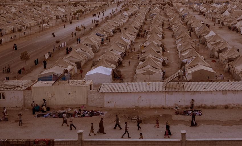
TABLE OF CONTENT

Introduction                                                                                 03

Natural Resource Management
Detection and monitoring of extraction of illegal resources                                  04
Detecting and monitoring trafficking of illegally extracted natural resources                05
Land use/land cover mapping                                                                  06
Assessment of agriculture resources                                                          07
Assessment of water resources                                                                08

Justice, Law and Early Detection of Onset of Crises
Support to election planning and implementation                                              09
Detection of illegal activities                                                              10
Detection of crimes against humanity                                                         11
Detection and monitoring of in-region displacements                                          12
Assessment of onset of violence                                                              13

Reconstruction and Development of Infrastructure
UXO assessment and planning                                                                  14
Damage characterization and reconstruction planning support                                  15
Support to establishment of property rights                                                  16
Infrastructure construction monitoring                                                       17

Environmental Security
Pollution and contaminated sites assessment                                                  18
Infectious diseases                                                                          19
Critical ecosystem assessment                                                                20

Support for operations in fragile states                                                     21

                                                          In 2017, the number of people
                                                          displaced from their homes was
                                                         at its highest since World War II
                                                                      (UNHCR)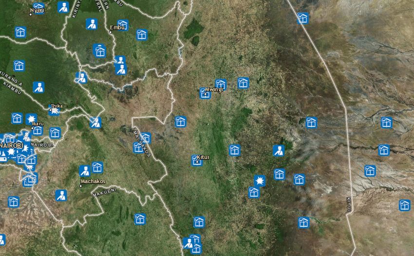
→ INTRODUCTION

FRAGILITY, CONFLICT AND SECURITY
In many parts of the world today, fragility in its many forms is a significant obstacle to environmental
and human security. Fragility, conflict, and violence is a critical development challenge and has
economic, political, environmental, security and societal dimensions that significantly affect a state’s
ability to provide security for their citizens and the environment on which they depend.

Fragility is a critical development challenge. Project or program activities in states affected by
fragility, conflict, and violence have unique challenges:

› Security concerns limiting access
› A dynamic environment
› Low capacity
Many actors such as NGOs and international financial institutions in the development community
aim to address the drivers of conflict and fragility, respond to crises, and develop resilience to climate
change, famine, pandemics and other global risks. Finding concrete solutions to the challenges faced
is difficult, but companies and organisations specialising in Earth Observation (EO) technology have
made considerable progress towards utilising new technology to create cost-effective, flexible and
affordable support to fragile states.

This project is a part of the European Space Agency’s (ESA) initiative called Earth Observation for
Sustainable Development (EO4SD), which aims at increasing the use of information and analysis
derived from EO technology in sustainable development efforts. ESA Fragility, Conflict and Security
focuses on adressing the information needs of actors working with or within fragile states by
capitalizing on new sources of EO data, such as the Copernicus program.

Adressing these needs is important because an increase in the utilisation of EO-based information
will provide affordable and effective means to improve environmental and human security in fragile
states, even though these contexts are challenging and complex. The following portfolio presents
the EO-based services available to organizations working to address challenges in fragile states and
to improve the situation for people and the environment.

  Definition of fragility:

  The Organisation for Economic Co-operation and Development (OECD) defines fragility as “[…] the combination of exposure
  to risk and insufficient coping capacity of the state, system and/or communities to manage, absorb or mitigate those risks.
  Fragility can lead to negative outcomes including violence, the breakdown of institutions, displacement, humanitarian
  crises or other emergencies” (OECD, 2016).

  Literature

  OECD (2016). States of Fragility 2016: Understanding Violence, OECD Publishing, Paris. Available:
  http://dx.doi.org/10.1787/9789264267213-en
  UNHCR (n.a). Figures at a Glance. Available: https://www.unhcr.org/figures-at-a-glance.html [11.01.19]

                                                                                                                                3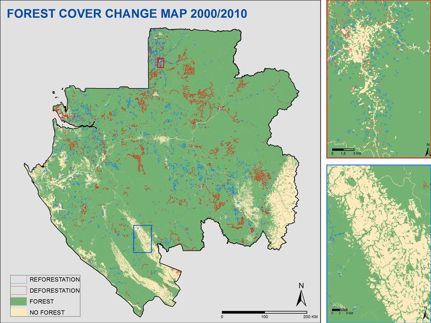
→ DETECTION AND MONITORING OF EXTRACTION OF ILLEGAL RESOURCES

 SERVICE DESCRIPTION
                                                                  Illegal resource extraction includes illegal fishing, mining extraction
                                                                  and deforestation. Not only are these issues environmentally
 Detects illegal fishing, mining extraction and deforestation     disastrous, they also negatively affect social and economic
 through various appropriate surveillance mechanisms              development in states that need it the most. Such issues can
                                                                  be difficult to detect and monitor because the areas involved are
 USE
                                                                  often small and spread over large distances. This requires the
 To improve knowledge of illegal activities and provide support   combination of multiple technologies and methods to determine
 to law enforcement actions                                       where resources are extracted illegally. Our service providers are
                                                                  joining their expertise and technologies to deliver the following
 DATA NEEDS
                                                                  services:
 Sentinel-2, SAR imagery and Very High Resolution (VHR)
 satellite imagery offering sub-meter resolution for precise      › D
                                                                      etection of illegal fishing through the identification of
 identification                                                      suspicious ships that are not being tracked by traditional vessel
 PRODUCT ACCURACY                                                    monitoring systems.
 30 cm to 1 m for infrastructure, 5 to 10 m for deforestation     ›D
                                                                    etection of illegal mining extraction through analysing images
 depending on the sensor                                           and identifying changes after areas of interests have been
                                                                   identified.
 RESOLUTION
                                                                  ›D
                                                                    etection of deforestation by comparing and analysing different
 From 10 m (Sentinel-2) to 1 m (VHR imagery)                       types of satellite images.
 BENEFIT
 Will enable stakeholders and policy makers to act against
 environmental crime

 DELIVERY FORMAT
 Maps in PDF format including satellite images, their analysis
 and a legend. Shapefiles can also be shared. Products should
 be made available through a secured File Transfer Protocol
 (FTP) or a web-based portal

 FREQUENCY
 Initial maps can be produced within a few hours of service
 activation. Refined analysis can be delivered within 2 weeks

                                                                  Deforestation map over Gabon (source: SIRS).

4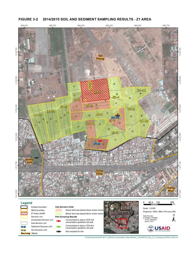
→ DETECTING AND MONITORING TRAFFICKING OF ILLEGALLY EXTRACTED NATURAL RESOURCES

Trade of illegal goods is characterised by large volumes of resources         SERVICE DESCRIPTION
being transported from multiple locations to ports and processing
facilities around the world, often by maritime shipping. This                 Maps maritime traffic acquired over long time series, focusing
applies to illegal fishing, mining and logging. Even small volumes            on illegal transport
of wildlife goods are transported at sea because there is less risk
                                                                              USE
of interception and arrest.
                                                                              To identify suspicious ships, routes and destinations and
This service tracks shipping vessels by satellite and gives a unique          provide sources for marine traffic intelligence and cartography
opportunity to record and reveal illegal networks. EO products and
satellite-based Automatic Identification Systems (AIS) can help               DATA NEEDS
fragile states to monitor and reduce such illegal activities. When            Sentinel-1 and AIS satellite data
AIS and Earth Observation (EO) data are combined, ships with
switched-off AIS transmitters can be identified and alarms can                PRODUCT ACCURACY
be sent to state authorities so that the ship’s information and
                                                                              200 m geometrical accuracy for ship detection with a false
travelling pattern can be inspected.
                                                                              alarm rate lower than 10%

                                                                              RESOLUTION
                                                                              Depending on needs

                                                                              BENEFIT
                                                                              May be used to support regulations, to strengthen patrols or to
                                                                              activate real-time surveillance

                                                                              DELIVERY FORMAT
                                                                              Maps in standard output from Geographic Information Systems
                                                                              (GIS) and ship detection reports

                                                                              FREQUENCY
                                                                              Can be delivered within one month after the collection of the
                                                                              last satellite data. Quarterly updates should be performed for a
                                                                              sustainable service

Ship detection using Sentinel-1 radar imagery and AIS vessel tracking along
Northeast coast of Madagascar (source: CLS).

                                                                                                                                                5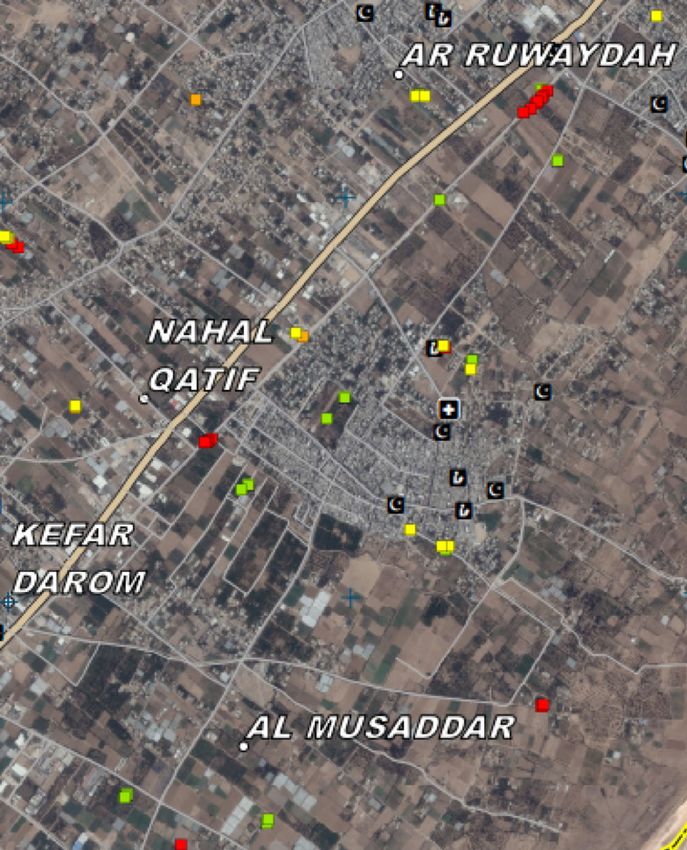
→ LAND USE/LAND COVER MAPPING

 SERVICE DESCRIPTION
                                                                   The lack of knowledge of current and past land cover and land
                                                                   use makes it difficult to plan for the future, which is key to
 Identifies land use and land cover through satellite imagery      addressing fragility. This service analyses generic geospatial data
                                                                   and determines changes and ongoing dynamics. Such knowledge
 USE
                                                                   is crucial to identify priority actions, create master plans and plan
 › Map distribution of specific thematic classes, changes and      investments in countries affected by fragility, conflict and a lack of
 intensity of changes in space and time, identify spatial and      security. Potential areas where this service can be applied include:
 temporal patterns of development and assess structural            urban planning and reconstruction, refugee camp detection and
 indicators                                                        monitoring, agriculture land assessment and development, natural
 › Identify spatial and temporal patterns of development           resources management, and identification of critical habitats.
 › Assess structural indicators
                                                                   Land Use/Land Cover (LULC) mapping provides explicit spatial
 › Assess composite indicators (combining EO and statistical       information regarding what is on the ground. This can include
 data)                                                             biophysical characteristics such as areas of vegetation, bare soil,
                                                                   hard surfaces, wetlands and water bodies. It can also describe
 DATA NEEDS                                                        areas in terms of their socio-economic purpose (areas used for
 Satellite imagery and historical data depending on user needs     residential, industrial or commercial purposes, for farming or
                                                                   forestry, for recreational or conservation purposes, etc.). Thematic
 PRODUCT ACCURACY                                                  areas can be defined according to user needs, area of interest,
 The thematic accuracy should be at least 80%                      EO data resolution and other contextual parameters. LULC evolves
                                                                   over time and change detection is made possible through satellite
 RESOLUTION                                                        imagery.
 From medium (10 m) to very high (1 m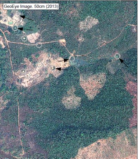
→ ASSESSMENT OF AGRICULTURE RESOURCES

Over the last decade, food security has become one of the world’s             SERVICE DESCRIPTION
greatest challenges. It is ranked second among the 17 Sustainable
Development Goals in the United Nations 2030 Agenda. Countries                Assesses different kinds of agricultural resources
affected by fragility are some of the most vulnerable in relation to
                                                                              USE
food security. To address this challenge effectively, a wide range
of timely data and information on food production, agricultural               To identify cropped areas, irrigated areas and crop types, to
practices and natural resources needs to be available and analysed,           monitor vegetation status and map land areas suitable for
and solutions need to be prioritised and designed. This service can           agricultural practices
contribute by identifying cropped and irrigated areas, monitoring
                                                                              DATA NEEDS
vegetation status over cropped areas, assessing land suitability
and identifying crop types.                                                   Sentinel-2 image time series combined with various types of
                                                                              data depending on user needs

                                                                              PRODUCT ACCURACY
                                                                              The thematic accuracy should be at least 80%

                                                                              RESOLUTION
                                                                              Resolution depending on the sensor used for satellite imagery
                                                                              (from 0.5 m to 20 m)

                                                                              BENEFIT
                                                                              Increases information on agricultural resources that enables
                                                                              better food production assessments and planning

                                                                              DELIVERY FORMAT
                                                                              Delivery format can be raster, vector and pdf

                                                                              FREQUENCY
                                                                              Frequency can be a 10-day period that is compared to an
                                                                              historical reference
Vegetation Status Maps (Vegetation Productivity Indicator see https://land.
copernicus.eu/global/products/vpi) for Zambia (source: SIRS).

                                                                                                                                              7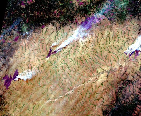
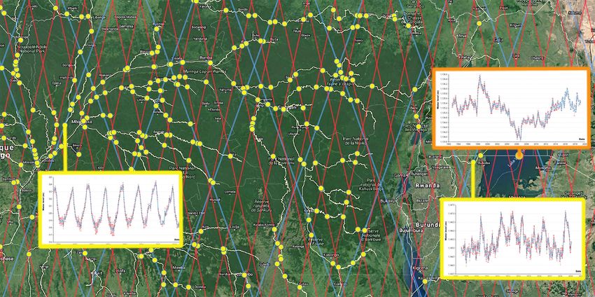
→ ASSESSMENT OF WATER RESOURCES

 SERVICE DESCRIPTION
                                                                            Failure to ensure water security often results in conflict situations
                                                                            and displacement of people, particularly when the water resource is
 Creates time series over water levels/surface areas of large               shared between several countries. This service offers assessment
 rivers and lakes                                                           of water resources which is essential for sustainable development
                                                                            in general and management of water resources in fragile states in
 USE
                                                                            particular. It is crucial to know the availability of drinking water for
 To visualise the evolution of water level as well as water                 populations and livestock when planning and operating projects
 presence in the area of interest, creating an input to                     related to irrigation and agriculture. This will aid adaptation to
 hydrological modelling                                                     climate change and help mitigate drought.
 DATA NEEDS                                                                 EO allows you to map the extent and change of water surfaces
 Radar altimetry data (1992 to present, e.g. from Topex/                    and the water level, which can be observed by measuring the time
 Poseidon to Sentinel-3) complemented by optical and radar                  it takes for radar pulses to reach the ground and return. Water
 imagery (e.g. Sentinel-2 and Sentinel-1)                                   level is computed as time series over lakes and rivers, at the
                                                                            intersections of the river network with the satellite ground tracks,
 PRODUCT ACCURACY                                                           so-called Virtual Stations.
 10 to 50 cm for water level (depending on river shape and
 altimetry mission) and 20 m for water presence                             Many other EO products related to management of water resources
                                                                            can be provided based on the service portfolio developed from
 RESOLUTION                                                                 past or ongoing ESA initiatives (TIGER, EO4SD Water).
 N/A for water level (not a geographical resolution, but a
 temporal resolution, ranging from 10 to 30 days) and 10 m for
 water presence

 BENEFIT
 Improves the understanding of hydrological processes in large
 river basins and their influence on climate variability and socio-
 economic life in fragile states

 DELIVERY FORMAT
 CSV file for water level and shapefiles or maps for water
 presence

 FREQUENCY
 Up to every day for water level operational surveillance

                                         Time series of water level in lake Victoria and Congo river (source: CLS).

8
→ SUPPORT TO ELECTION PLANNING AND IMPLEMENTATION

In addition to being valuable in itself, a safe and fair democratic      SERVICE DESCRIPTION
process is key to sustainable development. It can help build
trust in government authorities and cohesion in the population,          Creates elaborative large-scale live maps of countries,
thus helping to avoid conflict and instability. Despite this, many       displaying information that includes updates on violent events
elections remain flawed nowadays. Political violence can prevent         and irregularities
people from voting according to their opinion and stuffing of ballot
                                                                         USE
boxes may turn political participation into a meaningless exercise.
                                                                         To better document events, coordinate efforts and strengthen
GIS is a very useful tool to secure credible elections. A custom web     surveillance in specific areas
map can display various types of information such as administrative
boundaries of constituencies, location of poll centres, reported         DATA NEEDS
rallies, incidents and detected fires. These elements are essential      › GIS layers including administrative boundaries, location of
to adequately monitor the situation and understand the big picture       poll centres for instance
in order to prioritise efforts efficiently, whether before an election   › Sentinel-1, Pléiades and WorldView images. Other sub-meter
takes place, during or even after its implementation.                    sensors on a case by case basis
The information provided by this service can be interactive, with        PRODUCT ACCURACY
users reporting incidents directly through the UN-ASIGN app
                                                                         5 to 100 m accuracy (manual positioning or automatic
and adding pictures to text description. GIS support to election
planning and implementation may also include satellite imagery           geolocation)
analysis when requested to verify an incident, depending on              RESOLUTION
available sources.
                                                                         Sentinel-2 has optical resolutions down to 10 m, WorldView
                                                                         satellites have resolutions down to 31 cm. Pléiades images
                                                                         have resolutions down to 50 cm

                                                                         BENEFIT
                                                                         Provides sources for election monitoring and cartography, and
                                                                         facilitates the prioritisation of efforts by users

                                                                         DELIVERY FORMAT
                                                                         Web maps using ArcGIS Online that can be password protected

                                                                         FREQUENCY
                                                                         Up to daily, with live updates from users

Extract from a Kenya General elections webmap.

                                                                                                                                         9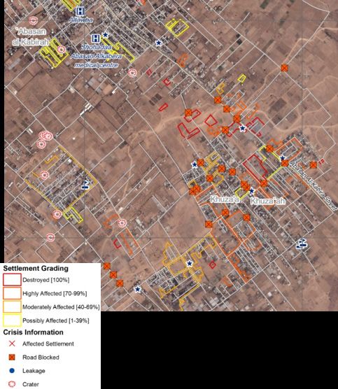
→ DETECTION OF ILLEGAL ACTIVITIES

 SERVICE DESCRIPTION
                                                                         Illegal activities can have devastating impacts on countries affected
                                                                         by fragility, and might counteract initiatives aimed at sustainable
 Creates elaborative maps in which various satellites images are         development. This service makes it possible to trace certain illegal
 analysed to identify proliferation of controlled materials, the         activities using EO data including the production of illicit crops,
 production of illicit crops or terrorist camps                          set up of terrorist training camps and proliferation of controlled
                                                                         materials.
 USE
 To support regulations or to strengthen patrols in given areas
 for specific periods and to better organise humanitarian and            This service can also:
 security efforts                                                        ›U
                                                                           se near-infrared band to gain knowledge on types of
                                                                          vegetation
 DATA NEEDS
                                                                         › Detect specific vehicle activity and structures
 Sentinel-2, Pléiades and WorldView images. Other sub-meter
 sensors on a case by case basis                                         ›U
                                                                           se the Normalized Difference Vegetation Index to assess the
                                                                          health of vegetation
 PRODUCT ACCURACY
                                                                         › Assess the extent of possible illicit crops
 30 cm to 10 m depending on the sensor used for satellite
                                                                         ›D
                                                                           etect specific elements such as training structures, people in
 imagery
                                                                          military formation or unusual vehicle activity
 RESOLUTION                                                              › Identify specific vehicles, weapons, structures, type and amount
 Sentinel-2 has optical resolutions down to 10 m, WorldView                of damage
 satellites have resolutions down to 31 cm. Pléiades images
 have resolutions down to 50 cm

 BENEFIT
 Allows better detection of illicit crops and other illegal activities
 upon request

 DELIVERY FORMAT
 Reports in PDF format including satellite images, their analysis
 and a legend. Shapefiles can also be shared. Products should
 be made available through a secured FTP

 FREQUENCY
 Can be ordered through the project web portal and delivered
 within one month after the acquisition of the image, depending
                                                                         Reported location of alleged Khan Shaykhun chemical attack.
 on the complexity of the analysis. Products can be privately
 or publicly shared depending on needs and confidentiality
 requirements

10
→ DETECTION OF CRIMES AGAINST HUMANITY
Crimes against humanity have been widespread in a number of SERVICE DESCRIPTION
countries in the last few years and fragile states are particularly
vulnerable. Such crimes include various acts committed as part Creates elaborative maps in which various satellites images are
of a widespread or systematic attack directed against civilians. analysed to identify crimes against humanity
Examples may include murder, enslavement or rape.
USE
The investigation of crimes against humanity can prove difficult To support investigations or to strengthen security presence in
at times, especially when they take place in dangerous and hard given areas at specific periods
to reach areas, but also because evidence can be tampered with
by the perpetrators or their allies. Information from EO can be DATA NEEDS
used to investigate and verify possible crimes against humanity, Pléiades, WorldView images and other sub-meter sensors on a
provided that their effects can be seen from the sky. Satellite case by case basis
images can sometimes be the only means to access evidence long
disappeared thanks to the use of archives. PRODUCT ACCURACY
30 cm to 1 m depending on the sensor used for satellite
imagery
RESOLUTION
WorldView satellites have resolutions down to 31 cm. Pléiades
images have resolutions down to 50 cm
BENEFIT
Provides sources for the detection of crimes against humanity
DELIVERY FORMAT
Reports in PDF format including satellite images, their analysis
and a legend. Shapefiles can also be shared. Products are
made available through a secured FTP
Baseline. FREQUENCY
Can be ordered through the project web portal and delivered
within one month after the acquisition of the image, depending
on the complexity of the analysis
Mass graves detection with satellite imagery.
11→ DETECTION AND MONITORING OF IN-REGION DISPLACEMENTS
SERVICE DESCRIPTION
In 2017, approximately 68.5 million people were forcibly displaced,
making it the highest number of displaced people since World
Allows analysts to digitise camps relatively quickly depicting War II. People being displaced from their home is a clear sign of
the location and number (or general trends like growth or fragility.
reduction) of displaced persons
The very precarious condition of many Internally Displaced People
USE (IDP), or refugees, is a hurdle to sustainable development. In
To create maps depicting the number and location of displaced order to get a clear overview of the problem it is important to have
persons. The types of infrastructures existing in the camps can a clear sense of locations and dynamics at play in each region. This
also be differentiated (administrative building, shelter etc.) service can obtain such information by using archive imagery that
enables analysts to highlight current crises but also draw trends
DATA NEEDS and general movement patterns.
Sentinel-2, Pléiades and WorldView images. Other sub-meter
sensors on a case by case basis
PRODUCT ACCURACY
30 cm to 10 m depending on the sensor used for satellite
imagery
RESOLUTION
Sentinel-2 has optical resolutions down to 10 m, WorldView
satellites have resolutions down to 31 cm. Pléiades images
have resolutions down to 50 cm
BENEFIT
Allows humanitarian actors to better coordinate efforts and
answer the needs of displaced persons
DELIVERY FORMAT
Maps in PDF format including satellite images, their analysis
and a legend. Shapefiles can also be shared. Products should This map illustrates satellite-detected areas of displaced persons shelters in
be made available through a secured FTP the Sangaya settlement, Borno state, Nigeria, and in the surrounding town of
Dikwa on 29 September 2016. © DigitalGlobe, Inc. Source: Department of State,
FREQUENCY Humanitarian Information Unit, NextView License. Analysis: UNOSAT.
Can be ordered through the project web portal and delivered
within 2 weeks after the collection of the last satellite image
depending on the scale of the analysis
12→ ASSESSMENT OF ONSET OF VIOLENCE
Monitoring low-intensity and early stages of violence is a good SERVICE DESCRIPTION
way to bring about more efficient operations and avoid more
severe incidents in the future. Information and analysis based on Makes it possible to identify several phases of violence before
EO data can be used to identify onsets of violence. it escalates progressively and regions end up torn in conflict
For instance, damaged and looted houses can be recognized using USE
EO. This allows for a quick assessment of the situation in locations To create maps in which various satellite images are analysed
that can otherwise be too far away or too dangerous to reach. to assess damages or signs of violence
EO technologies can also be used to directly detect some types
of violent events soon after they occurred, and sometimes even DATA NEEDS
when there is no report of the incident thanks to fire detection for Pléiades and WorldView images. Other sub-meter sensors on a
example. Early damage and security assessments can be produced case by case basis
as part of this service.
PRODUCT ACCURACY
30 cm to 1 m depending on the sensor used for satellite
imagery
RESOLUTION
WorldView satellites have resolutions down to 31 cm and
Pléiades images have resolutions down to 50 cm
BENEFIT
Allows analysts to notify relevant actors of the onset of
violence. Aims to create an efficient warning system
DELIVERY FORMAT
Maps in PDF format including satellite images, their analysis
and a legend. Shapefiles can also be shared. Products should
be made available through a secured FTP
FREQUENCY
Web-based ordering system through the project web portal
with direct notification. Can be updated every day in times of
crises. Refined analysis can be delivered within 2 weeks after
the onset of violence depending on the complexity of the case
at hand
This map extract illustrates satellite-detected damage and destruction between
6 and 12 July 2014 in Nahal Qatif and Al Musaddar, Gaza, due to violence in the
area. Image source: © Airbus DS, 2014. Analysis: UNOSAT.
13→ UXO ASSESSMENT AND PLANNING
SERVICE DESCRIPTION
Recent and historical conflicts present risks to human populations
in areas contaminated by explosive remnants of war, which
Compiles and analyses GIS and remote sensing datasets that includes mines and unexploded ordnance (UXO). Clearance is time-
support prioritisation of UXO clearance activities, completes consuming and costly, but EO data and a risk-based approach can
non-technical surveys, and leads to efficiencies in UXO support clearance planning, focus it on high-risk areas, and reduce
programmes costs to clear land for communities. The process starts with a
pre-technical survey and is followed up by clearance operations
USE
support.
To work with international partners gaining capacity in using
The first step is to characterize the UXO hazard. Satellite image
satellite imagery and GIS as a part of contaminated site
change detection can identify disturbances that may indicate UXO
screenings and site risk assessments
contamination, such as craters, damaged infrastructure, or building
DATA NEEDS rubble. Risk assessment integrates data such as population
density, livelihoods, and land use in hazardous areas.
EO data (e.g. Sentinel-2 for regional context and land cover
and land use), elevation, historical records of bombing, UXO
clearance records and historical satellite EO data (e.g. Corona
spy satellite)
PRODUCT ACCURACY
Land cover classification will be delivered with 80 to 90%
classification accuracy, depending on stakeholder requirements
and the availability of validation data
RESOLUTION
Medium resolution (e.g., Sentinel-2, RapidEye, and Landsat)
with a spatial resolution ranging from 5 m to 30 m) and
high resolution (e.g., Worldview and Pleiades) with a spatial
resolution ranging from sub-meter to 3 m
BENEFIT
More efficient screenings of sites with up-to-date information
DELIVERY FORMAT
Maps and products produced in standard GIS format. Products
should be made available through a secured FTP or web-based
portal
FREQUENCY
Baseline within 1-2 weeks of ordering, depending on size of
area and availability of ancillary data and satellite EO data
Example of crater extraction from Corona imagery in Laos.
14→ DAMAGE CHARACTERISATION AND RECONSTRUCTION PLANNING SUPPORT
Conflict or external shocks such as natural disasters can be direct SERVICE DESCRIPTION
causes of fragility and violence. In any case, the fragility of a state
causes a lack of reliable information on the existing infrastructure Creates reference and damage assessment maps pre-and post-
and an increased level of social vulnerability to any kind of disaster. conflict
Therefore, early characterisation of damages is a prerequisite for
USE
relief efforts and reconstruction planning support.
To identify transport infrastructure necessary for reconstruction
Damage characterisation following a conflict, and/or natural or and assess the degree of damages in order to prioritise and/or
manmade disasters requires the establishment of a reference prior adapt reconstruction efforts
to the event and a post-event situation to identify the areas that
were affected. DATA NEEDS
VHR satellite imagery. Pleaides, WorldView or equivalent
images
PRODUCT ACCURACY
30 cm to 1 m depending on the sensor used for satellite
imagery
RESOLUTION
WorldView satellites has resolutions down to 31 cm and
Pléiades images has resolutions down to 50 cm
BENEFIT
The identification and grading of the damages inflicted to
infrastructure is useful to determine the extent and severity of
the infrastructure destruction to start identifying priorities and
plan for reconstruction
DELIVERY FORMAT
Maps in selectable PDF format including satellite images, their
analysis and a legend. Shapefiles can also be shared. Data
publicly or privately shared depending on needs
FREQUENCY
Initial map can be produced within few hours of service
activation. Refined analysis delivered within 2 weeks
The picture shows an extract of a damage assessment map produced by SIRS
for the Copernicus Emergency Management Service – Rapid Mapping. This
activation over the Gaza strip was related to a military intervention by the Israeli
army during Summer 2014 and was classified as sensitive and provided to end
users (UN bodies) only through a secure FTP server without any publication on
the service website. It provides damage assessment on buildings and roads and
additional crisis information such as craters caused by bomb impact.
15→ SUPPORT TO ESTABLISHMENT OF PROPERTY RIGHTS
SERVICE DESCRIPTION
Establishing and securing property rights can influence economic
development and might be key to alleviate poverty. The lack of
Supports the establishment of property rights in several clarity regarding property rights is also a potential cause of conflict
regions of the world and fragility. An example of this would be the lack of agreement
regarding land use between crop farmers and nomadic cattle and
USE
sheep breeders in the Sahel which regularly causes conflicts (18
To support the establishment of a basis for a land parcel people died last year in Niger).
information system and resolving uncertainties regarding
property rights. Can also be used to distinguish between Establishing property rights can often be very difficult in the
different land uses absence of any cadastral information or if there are several land
registration systems (e.g. in Madagascar where the former colonial
DATA NEEDS system brought by France coexists with the traditional system,
Pléiades, WorldView or equivalent images. Sentinel-2 could resulting in different rights on the same land parcel). This service
also be relevant for more generic land cover/use information can support the establishment of property rights by providing up
to date information that can be used to form a basis for discussions
PRODUCT ACCURACY on property distribution and land information systems.
30 cm to 1 m depending on the sensor used for satellite
imagery
RESOLUTION
Sentinel-2 has optical resolutions down to 10m, WorldView
satellites have resolutions down to 31 cm. Pléiades images
have resolutions down to 50 cm. VHR imagery will be required
most of the time due to the specifications of the product
BENEFIT
Makes it easier to manage land information systems and
enables constructive discussions regarding land use and parcel
distribution
DELIVERY FORMAT
Maps in selectable PDF format including satellite images, their
analysis and a legend. Shapefiles can also be shared. Data
publicly or privately shared depending on needs Detailed land parcel physical
boundaries and land cover
FREQUENCY information including building
footprints for Bilma, Niger.
Initial map can be produced within few hours of service
activation. Refined analysis delivered within 2 weeks
16→ INFRASTRUCTURE CONSTRUCTION MONITORING
Many regions around the world are difficult to access due to SERVICE DESCRIPTION
the lack of infrastructure, high level of conflicts and/or terrorist
activities reported. Such situations make it almost impossible Monitors infrastructure construction using satellite imagery
to monitor infrastructure construction related to transportation
USE
network, water resource management or public buildings. Using
satellite images is a cost-effective way to ensure that the money To monitor the work progress on infrastructure construction
distributed for building strategic infrastructure is invested wisely or the extent of urban settlement and survey existing critical
in fragile states. infrastructure
DATA NEEDS
Sentinel-1 and 2
PRODUCT ACCURACY
The thematic accuracy should be at least 80%
RESOLUTION
Medium to very high resolution. Due to the specifications of the
product, VHR imagery will be required most of the time
BENEFIT
Makes it easier and more cost-effective to make investments to
build strategic infrastructure
DELIVERY FORMAT
Reference and change detection maps with associated geo-
data. Data publicly or privately shared depending on needs
FREQUENCY
Regular intervals
The picture is an example of VHR mapping results of urban areas (level 4
classification) in the northeast of Baghdad, Iraq to support reconstruction work
and infrastructure planning (source: SIRS).
17→ POLLUTION AND CONTAMINATED SITES ASSESSMENT
SERVICE DESCRIPTION
Conflict, industrial operations, and poor land management may
cause pollution and contamination of water, soils, and biological
Identifies pollution and contaminated sites through the organisms. This service is designed to support approaches for
analysis of EO data and supporting information management and prioritisation of interventions to reduce the
human health impacts caused by these issues. The approaches
USE
include Site Selection and Prioritisation, Conceptual Site Models,
Site Selection and Prioritisation, Conceptual Site Models, and and Site Characterisation. Certain incidents may require a rapid
Site Characterisation, risk assessment and decision making response to detect, map, and characterise pollution (e.g. sabotage
of oil and gas fields or industrial accidents), which is where this
DATA NEEDS
service can play a key role.
› EO data (e.g. Sentinel-2 for regional context and land cover
and land use screening) The first approach (Site Selection and Prioritisation) aims to
› Elevation and derived drainage data (e.g. WorldDEM™) identify sites with high likelihood of contamination hazards, while
the second approach (Conceptual Site Models) is used to identify
› Historical records of contaminant use and handling
human and ecological receptors and to identify exposure pathways.
› Current contamination data or human health records (provided The third approach (Site Characterisation) focuses on producing
by stakeholder/project partner)
detailed characterisation of sites by creating elaborate maps
using EO data and historical air photos. Furthermore, integration
PRODUCT ACCURACY of EO derived information into geospatial modelling supports risk
Land cover classification will be delivered with 80 to 90%
assessments and decision making.
classification accuracy, depending on stakeholder requirements
and the availability of validation data
RESOLUTION
From 10 m (Sentinel-2) to 1 m (VHR imagery)
BENEFIT
Gives international partners the capacity to use satellite
imagery and GIS as part of contaminated site screenings and
site risk assessments resulting in more efficient screening of
sites with up-to-date information
DELIVERY FORMAT
Maps and products in standard GIS format
FREQUENCY
Baseline within 1-2 weeks of ordering, depending on the size
of the area and availability of ancillary data and satellite EO
data
Environmental assessment of dioxin contamination at Bien Hoa
Airbase, Vietnam.
18→ INFECTIOUS DISEASES
Diseases that severely affect humans, animals, and plants can SERVICE DESCRIPTION
be significant obstacles to sustainable development and might
exacerbate existing vulnerabilities in communities. They are Detecs disease outbreak by distinguishing areas that
affected by diseases determined by interconnected environmental experience epidemic and seasonal transmission from those
variables that can affect incidence, transmission, and outbreak. with more stable or continuous transmission patterns, and by
executing a continuous and systematic analysis of relevant data
This service combines EO and image processing to develop maps for early detection of disease outbreak
of disease transmission risk. Information derived from EO can
support health interventions for infectious diseases, including USE
risk assessment, surveillance, and early detection. Multiple To identify primary and secondary disease reservoir habitats.
environmental and climatic indicators for disease can be developed. Applicable to many important human and veterinary vector-
The EO4SD services support experts that are seeking systematic borne diseases in Africa
datasets with improved spatial resolution or temporal frequency
to improve models. DATA NEEDS
› EO data (e.g. Sentinel-2 or Landsat; Sentinel-1 for hydrological
dynamics)
› Elevation and derived drainage data (e.g. SRTM, WorldDEM™)
› Households and population density, livelihoods, outbreak data
records and incidents
› Ancillary GIS data: land use, historical vector-based layers,
soil type, etc
› Base map and administrative data: administrative boundaries,
roads, hydrology, soil type, etc
PRODUCT ACCURACY
Habitat detection with 80 to 90% classification accuracy,
depending on the availability of validation data
RESOLUTION
Medium resolution with a spatial resolution ranging from 5 m
to 30 m, and high resolution with a spatial resolution of less
than 1 m
BENEFIT
Creates fine-spatial resolution maps over large extents to
produce risk maps at the appropriate operational scale for
Predicted exposure to infectious mosquitos in the rainy season in central Gambia. public health interventions
The River Gambia is shown in black; gray line is the international border with
Senegal; solid circles are villages. DELIVERY FORMAT
Maps and products in standard GIS format
FREQUENCY
› Baseline within 1 to 2 weeks of ordering, depending on size
of area and availability of ancillary data and satellite EO data
› Monitoring and change detection in habitat within 24 hours of
image acquisition
19→ CRITICAL ECOSYSTEM ASSESSMENT
SERVICE DESCRIPTION
Ecosystems are at risk due to the high demand for the goods and
services they provide, poor management, and climate change, a
Creates maps of ecosystems to support environmental security situation that might exacerbate fragility and pose an additional
planning, conservation planning, risk assessment, and public obstacle to improving the lives of people living in fragile contexts.
awareness
Satellite EO data can provide information to assess and monitor
USE critical ecosystems to inform decision-makers of potential issues
To standardise information for park management across themes such as degradation and drought that can exacerbate existing
(security, conservation) and integrate this with standard GIS social and economic challenges. Critical ecosystem assessment
and Google Earth covers diverse environments depending on a project’s needs,
including terrestrial, freshwater aquatic, and coastal foreshore/
DATA NEEDS intertidal information needs. Satellite EO data can provide specific
› EO data (e.g. Sentinel-2 or Landsat; Sentinel-1 for hydrological information useful for assessing ecosystem processes such as
dynamics) land degradation, deforestation and forest degradation, changes
› Elevation and derived drainage data (e.g. SRTM, WorldDEM™)
to water resources and critical habitats.
› Biodiversity or other data to develop critical habitat
assessment criteria (provided by stakeholder/project partner)
PRODUCT ACCURACY
Land cover classification will be delivered with 80 to 90%
classification accuracy, depending on stakeholder requirements
and the availability of validation data
RESOLUTION
Medium resolution with a spatial resolution ranging from 5 m
to 30 m
BENEFITS
› Increases planning capacity and makes the process to define
priorities more efficient
› Provides health and safety benefits through informing the risk
assessment process
› Improves preparation and planning for patrol teams
› Makes strong communications materials available for annual
reporting and donor engagement
DELIVERY FORMAT Sentinel-2 image acquired on Dec 28, 2015 depicting wildfires over Garamba
Maps and products in standard GIS format National Park in the Democratic Republic of the Congo.
FREQUENCY
› Baseline within 1-2 weeks of ordering, depending on size of
area and availability of ancillary data and satellite EO data
› Monitoring and change detection in habitat with 24 hours of
image acquisition
20→ SUPPORT FOR OPERATIONS IN FRAGILE STATES
Remote sensing data and analysis provide cost-effective, timely, Implementation and supervision
and flexible support to operations in fragile states across the project Provision of information on project progress where site visits are
cycle, including identification and preparation, implementation and challenging and to develop evidence that the project is achieving
supervision, and evaluation. The following is an overview of how the intended purpose. EO images and products can monitor:
EO service providers can support projects in the different stages
›D
evelopment of land use, e.g. improvement in crop production
of the project cycle:
›N
atural resources development, e.g. enhanced palm oil supply
Identification and preparation
chain
Support to the examination of technical, economic, social, and
› Ecosystem rehabilitation, e.g. mangroves restoration
environmental aspects of a proposed project. EO images and
products can identify: › Infrastructure development, e.g. confirm bridge replaced,
repaired irrigation, aquaculture
› Status of natural resources
›U
rban development, e.g. confirm housing improvements
› Status of existing infrastructure
Evaluation
› Status of populations, land use, and the human environment
Provision of data for monitoring and evaluation following project
› Environmental change drivers, e.g. agriculture, water resources
implementation and independent evaluation systems in response
During preparation, project performance indicators can be to project performance measures. EO images and products provide:
monitored using remote sensing, potentially reducing supervision
› C ompelling visual evidence of project results
and evaluation costs.
› Before and after project comparisons
›R
igorous and transparent information
› Information for areas with access constraints
21Partners of the Fragility Cluster
For more information, please contact:
ESA Technical Officer: Gordon
Anna Burzykowska
Campbell - Gordon.Campbell@esa.int
- Anna.Burzykowska@esa.int
Project Lead: Jean-Yves
Remco DostLebras
- Remco.Dost@eleaf.com
- jlebras@groupcls.com
http://eo4sd.esa.int/fragilityYou can also read