Green Infrastructure - South Dublin County Council
←
→
Page content transcription
If your browser does not render page correctly, please read the page content below
Green
Infrastructure
Vision

                                                             Green Infrastructure (GI)
Promote the development of an integrated
GI network for South Dublin County
working with and enhancing existing
biodiversity and natural heritage, improving
our resilience to climate change and
enabling the role of GI in delivering
sustainable communities to provide
environmental, economic and social
benefits.

DRAFT SOUTH DUBLIN COUNTY DEVELOPMENT PLAN 2022-2028   131
4.0 Introduction Balance is the key to the success of the GI based approach to climate action.
Increased densities should be delivered in tandem with sustainable GI and other
This chapter of the Development Plan, alongside the associated maps, sets out the mitigation measures such as increased use of renewable technologies (See Chapter
Green Infrastructure Strategy for the County. The EU defines Green Infrastructure (GI) 10 Energy).
as:
4.0.2 Planning Policy Context
“ a strategically planned network of natural and semi-natural areas with other
environmental features designed and managed to deliver a wide range of Development Plan policies and objectives must be consistent with national and
regional planning policy as set out in the National Planning Framework (NPF) and
ecosystem services such as water purification, air quality, space for recreation and
Regional Spatial and Economic Strategy (RSES). A number of policies and objectives
climate mitigation and adaptation.”
in these documents are particularly relevant to the role of GI in national and regional
policy:
It comprises the interconnected network of natural, semi-natural and artificial
habitats, green spaces and ecological assets that traverse our urban and rural areas.
àà National Policy Objective (NPO) 58 requires that ‘Integrated planning for GI and
A healthy and well-connected GI network provides a range of social, economic and
ecosystem services will be incorporated into the preparation of statutory landuse
ecological benefits. Protecting natural features and combating habitat fragmentation
plans’
improves biodiversity, filters pollutants and helps to improve air and water quality as
well as preventing flooding by helping to control surface water runoff. From a
The NPF also states that: GI planning will inform the preparation of regional and
placemaking perspective, it is an asset that can raise the profile of the County,
metropolitan strategies and city and county development plans by:
influence business decisions to invest and encourage people to live and work in the
County. As an integral component of building well designed and sustainable
àà Assisting in accommodating growth and expansion, while retaining the intrinsic
communities it is key to the success of the overall concept of connected, compact
value of natural places and natural assets;
growth avoiding the damage created to the environment and climate through urban
àà Providing increased certainty in planning by proactively addressing relevant
sprawl and facilitating improved physical and mental wellbeing. In this way GI is a
environmental issues;
holistic approach to land use planning which balances spatial, social and economic
àà Encouraging more collaborative approaches to plan-making by enabling
development in a way that enhances the natural environment.
examination of the interactions between future development requirements and
the capacity of receiving areas; and
Green Infrastructure (GI)
Green Infrastructure (GI)
4.0.1 GI and Climate Action
àà Ensuring that sufficient and well-planned green spaces, commensurate in scale to
long-term development requirements, are designated in statutory plans.
Since the publication of the previous County Development Plan 2016-2022, the wider
legislative and policy landscape underpinning GI planning has evolved. It is
Under GI-Biodiversity-Landscape, the NPF notes that: ‘It is also important to consider
acknowledged that we are living in an era of damaging climate change and
the interrelationships between biodiversity, natural heritage, landscape and our green
biodiversity loss. In acknowledgement of this, the government has declared a climate
spaces.’
and biodiversity emergency and has increased our targets towards a carbon neutral
economy.
àà NPO 59 requires that Local Authorities ‘Enhance the conservation status and
improve the management of protected areas and protected species’
The likely impacts of climate change in South Dublin County include increased
àà NPO 60 requires that policy ‘Conserve and enhance the rich qualities of natural
flooding risk, increased frequency of summer drought conditions as well as
and cultural heritage of Ireland in manner appropriate to their significance’
deteriorating air and water quality and biodiversity loss.
àà NPO 62 requires that policy ‘Identify and strengthen the value of greenbelts and
GI is now considered to be essential to the success of climate change mitigation and green spaces at a regional and city scale, to enable enhanced connectivity to
adaptation measures through nature-based solutions. While recognising that future wider strategic networks, prevent coalescence of settlements and to allow for the
development will result in higher energy demands, the potential for the environment long-term strategic expansion of urban areas.’
to act as a balance to climate change is now central to the national and regional
policy approach to climate change. GI includes urban and rural components, some The RSES also provides clear guidance for Local Authorities on climate action and GI.
natural, some man made. Through evaporation, cooling and shading it also assists in The RSES provides for ‘Enhanced GI’ as a key Regional Strategic Outcome:
the management of temperature. The integration of GI into new development and
retrofitting in existing areas contributes to sustainable development, placemaking àà RSO 10: Enhanced GI ‘Identify, protect and enhance GI and ecosystem services in
and the success of the compact growth approach. the Region and promote the sustainable management of strategic natural assets
132 DRAFT SOUTH DUBLIN COUNTY DEVELOPMENT PLAN 2022-2028 DRAFT SOUTH DUBLIN COUNTY DEVELOPMENT PLAN 2022-2028 133
such as our coastlines, farmlands, peatlands, uplands woodlands and wetlands           framework for GI in the County. This highlights existing strengths and opportunities
                                  (NSO 8, 9)’                                                                            to further expand and enhance the County’s GI network. The GI framework is based
                                                                                                                         on the identification of a network of core areas, stepping stones and local and
                            The Dublin Metropolitan Area Strategic Plan (MASP) included in the RSES identifies           strategic corridors. A detailed analysis of the quality and potential opportunities
                            key GI assets within the Dublin Metropolitan Area, several of which are located in           presented by these assets, produced a suite of objectives, which when delivered will
                            South Dublin County. These include the Dublin/Wicklow Mountains, River Dodder, the           see the emergence of a robust GI infrastructure.
                            Liffey Valley Special Amenity Area and Tymon Park, all of which are incorporated into
                            the GI Strategy.                                                                             The Strategy will serve the County and the region for generations to come, and in the
                                                                                                                         longer term fulfil the requirements of national and regional policy. Six strategic GI
                            The Climate Strategy of the optimum development scenario for the RSES states that            corridors and associated objectives are set out in this chapter. A further eleven local
                            it is policy to ‘support achievement of our national climate obligations, and also to        corridors, which link to and enhance the primary corridors, together with objectives
                            develop regional GI and ecosystem services together with site-based alternatives for         for the protection and future enhancement of these corridors - is set out in Appendix
                            adaptation/mitigation of impacts in strategic development locations.’ It further states      4, Green Infrastructure, Local Objectives and Case Studies.
                            that Local Authorities should follow the ecosystem services approach integrating
                            biodiversity protection, water management and climate action. It requires Local                    Policy GI1: Overarching
                            Authorities to ensure the protection of GI assets through the development
                            management process and to facilitate the interconnection of GI assets across the                   Protect, enhance and further develop a multifunctional GI network, using an
                            region. Local Authorities are asked to consider opportunities for carbon sequestration             ecosystem services approach, protecting, enhancing and further developing the
                            (capturing and storing carbon) and integration of natural and built heritage when                  identified interconnected network of parks, open spaces, natural features,
                            considering development.                                                                           protected areas, and rivers and streams that provide a shared space for amenity
                                                                                                                               and recreation, biodiversity protection, water quality, flood management and
                            àà RPO 7.12 ‘Local Authorities shall promote an Ecosystem Services Approach in the
                                                                                                                               adaptation to climate change.
                               preparation of statutory land use plans.’                                                       GI1 Objective 1:
                            àà RPO 7.16 ‘Support the implementation of the Habitats Directive in achieving an                  To establish a coherent, integrated and evolving GI Network across South
                               improvement in the conservation status of protected species and habitats in the                 Dublin County with parks, open spaces, hedgerows, trees including public
                               region and ensure alignment between the core objectives of the EU birds and                     street trees and native mini woodlands (Miyawaki-Style), grasslands, protected
                               Habitats Directives and local authority development plans’
Green Infrastructure (GI)

                                                                                                                                                                                                                        Green Infrastructure (GI)
                                                                                                                               areas and rivers and streams and other green and blue assets forming strategic
                            àà RPO 7.17 ‘Facilitate cross boundary co-ordination between local authorities and                 links and to integrate and incorporate the objectives of the GI Strategy
                               the relevant agencies in the Region to provide clear governance arrangements                    throughout all relevant land use plans and development in the County.
                               and co-ordination mechanisms to support the development of ecological
                               networks and enhanced connectivity between protected sites while also                           GI1 Objective 2:
                               addressing the need for management of alien invasive species and the                            To implement and monitor the South Dublin County GI Strategy during the
                               conservation of native species.’                                                                lifetime of this plan and develop a fit for purpose GI scoring for the County
                                                                                                                               which will support ongoing identification, protection, enhancement and
                            There are many other relevant national and regional policy objectives. These are                   management of GI in the County and which will enable the assessment and
                            referenced by number within individual Development Plan policies and objectives in                 monitoring of GI interventions in the County.
                            this chapter and are set out in full at Appendix 7.                                                GI1 Objective 3:
                                                                                                                               To facilitate the development and enhancement of sensitive access to and
                            4.1 Methodology                                                                                    connectivity between areas of interest for residents, wildlife and biodiversity,
                                                                                                                               and other distinctive landscapes as focal features for linkages between natural,
                            An iterative approach was employed in the formulation of this strategy, with policy                semi natural and formalised green spaces where feasible and ensuring that
                            proposals and objectives based on a detailed assessment of the existing GI network                 there is no adverse impact (directly, indirectly or cumulatively) on the
                            in the County. The County’s parks, open spaces, rivers, waterbodies, habitats, natura              conservation objectives of Natura 2000 sites and protected habitats outside of
                            sites, landscape character types (see Chapter 3 Natural, Cultural and Built Heritage)              Natura 2000 sites.
                            and other green and blue assets were mapped in detail. The blueprint of the existing
                            GI network in the County has emerged from this process (See Figure 4.3).
                            Analysis of the potential of the existing elements and assets have led to the
                            identification of key GI assets along with the development of a vision and spatial

                            134                                   DRAFT SOUTH DUBLIN COUNTY DEVELOPMENT PLAN 2022-2028   DRAFT SOUTH DUBLIN COUNTY DEVELOPMENT PLAN 2022-2028                                     135
Key Themes:
GI1 Objective 4:
To require development to incorporate GI as an integral part of the design and
layout concept for all development in the County including but not restricted 4. 5.
2.
to residential, commercial and mixed use through the explicit identification of 1. Sustainable
3. Recreation Landscape,
GI as part of a landscape plan, identifying environmental assets and including Climate and Amenity Natural,
Biodiversity Water
Resilience (Human Health Cultural and
proposals which protect, manage and enhance GI resources providing links to Management
and Wellbeing) Built Heritage
local and countywide GI networks.
GI1 Objective 5:
Continue to liaise with adjoining local authorities to ensure the protection and 4.2.1. Biodiversity
enhancement of cross county GI corridors.
Biodiversity encompasses all of the different kinds of life on earth and the various
GI1 Objective 6:
ways these lifeforms interact with each other and their environment. The complex
To collaborate with Kildare County Council to identify a common approach to a
interactions that occur between different species and organisms are essential to
greenbelt/green spaces between the growing settlements within South Dublin
support and sustain human life. Clean air and water, food, medicine and other natural
and Kildare County Councils within the lifetime of the Development Plan and to
resources that are essential to everyday life are all dependant on the protection and
advise the councillors of any such collaboration and proposed study or
development of healthy, biodiverse habitats and ecosystems. Healthy biodiversity is
approach.
at the core of the ecosystem services approach to development. Ecosystems and
GI1 Objective 7: biodiversity help mitigate climate change impacts, by absorbing excess flood water
To develop linked corridors of small urban ‘Miyawaki’ native mini-woodlands, a or buffering us against extreme weather events. Forests, peatlands and other habitats
minimum of 100sqm in size, to capture carbon and encourage biodiversity in are major stores of carbon. Protecting them can also help us limit atmospheric
suitable existing built-up areas, in low grade parkland, and other areas of zoned greenhouse gas concentrations. This Plan adopts a proactive approach to the
lands where deemed suitable and appropriate. preservation and enhancement of biodiversity in South Dublin County by promoting
the protection of existing and the restoration of degraded habitats in the County and
GI1 Objective 8:
combating habitat fragmentation through the recognition within the GI strategy of
To increase over the lifetime of this plan the percentage of land in the County,
the contribution of biodiversity to the enhancement of existing and creation of new
including residential, managed for biodiversity including supporting the
linkages and corridors as part of the County’s GI network.
Green Infrastructure (GI)
Green Infrastructure (GI)
delivery of the objectives of the County Pollinator Plan and to continue to
investigate the potential for the use of low-mow methods during the lifetime of
the Plan. “Biodiversity is the variability among living organisms
from all sources including, inter alia, terrestrial, marine
4.2 Strategic Themes and other aquatic ecosystems and the ecological
GI planning is a positive and proactive approach to land use planning that aims to complexes of which they are part; this includes genetic
secure the delivery of a broad range of ecosystem services. It is multifunctional and diversity within species, between species and of
can deliver multiple and mutual environmental, social and economic benefits. The GI
policies for South Dublin County are organised under the following five themes in ecosystems.” United Nations Convention on Biological
order to reflect this broad range of ecosystem services and benefits it provides.
Diversity”
These themes are mutually supporting, with specific policies helping to contribute to
a stronger and more resilient county-wide GI Network.
From the foothills of the Dublin Mountains to the Liffey Valley and the local and
regional parks in between, South Dublin County contains a wide range of
biodiversity-rich areas. Several of these habitats are protected at the European level
under the Birds and Habitats Directives and are designated as part of the Europe-
wide Natura 2000 network. The three Natura 2000 sites in South Dublin County are
Glenasmole Valley SAC, and the Dublin/Wicklow Mountains SAC and SPA (refer to
Chapter 3 Natural, Cultural and Built Heritage).
136 DRAFT SOUTH DUBLIN COUNTY DEVELOPMENT PLAN 2022-2028 DRAFT SOUTH DUBLIN COUNTY DEVELOPMENT PLAN 2022-2028 137
Seven sites of special ecological interest in the County are designated as proposed
                                                                                                                                GI2 Objective 2:
                            Natural Heritage Areas, including the Dodder Valley, Liffey Valley and Lugmore Glen.
                                                                                                                                To protect and enhance the biodiversity and ecological value of the existing GI
                            The Plan promotes the full utilisation of local planning powers to minimise the risk of
                                                                                                                                network by protecting where feasible (and mitigating where removal is
                            degradation to these areas. The regional and local parks and public open spaces
                                                                                                                                unavoidable) existing ecological features including tree stands, woodlands,
                            within the County serve as home to various native plant, animal and bird species and
                                                                                                                                hedgerows and watercourses in all new developments as an essential part of
                            are important areas of biodiversity in their own right. The Plan aims to enhance the
                                                                                                                                the design and construction process.
                            biodiversity of these existing public open spaces and promote the development of
                            new local parks and spaces, to protect and promote biodiversity across the County.                  GI2 Objective 3:
                                                                                                                                To retrospectively repair habitat fragmentation and provide for regeneration of
                                                                                                                                flora and fauna where weaknesses are identified in the network through the
                            Native pollinator species, such as the bumblebee and                                                implementation of new GI interventions.
                            honeybee perform a vital role in preserving Ireland’s                                               GI2 Objective 4:
                            biodiversity by pollinating crops, plants and flowers. The                                          Integrate GI, and include areas to be managed for biodiversity, as an essential
                                                                                                                                component of all new developments in accordance with the requirements set
                            All-Ireland Pollinator Plan aims to provide for the                                                 out in Chapter 13 Implementation and the policies and objectives of this
                            protection of pollinators, many of which have suffered                                              chapter.

                            decline in recent years due to habitat fragmentation                                                GI2 Objective 5:
                                                                                                                                To protect and enhance the County’s hedgerow network, in particular
                            and the use of pesticides. The National Plan contains a                                             hedgerows that form townland, parish and barony boundaries recognising their
                            variety of measures aimed at supporting pollinator                                                  historic and cultural importance in addition to their ecological importance and
                                                                                                                                increase hedgerow coverage using locally native species including a
                            species, such as reducing use of pesticides, creating                                               commitment for no net loss of hedgerows on any development site and to take
                            wildflower meadows and reducing the frequency of                                                    a proactive approach to protection and enforcement.

                            mowing on publicly owned green spaces. The Council                                                  GI2 Objective 6:
                                                                                                                                To continue to support and expand the County Pollinator Plan through the
                            has incorporated these suggestions into this GI
Green Infrastructure (GI)

                                                                                                                                                                                                                          Green Infrastructure (GI)
                                                                                                                                management and monitoring of the County’s pollinator protection sites as part
                            Strategy to help protect South Dublin County’s                                                      of the Council’s commitment to the provisions of the National Pollinator Plan
                                                                                                                                2021-2025.
                            biodiversity.
                                                                                                                                GI2 Objective 7:
                                                                                                                                To enhance the biodiversity value of publicly owned hard infrastructure areas
                                  Policy GI2: Biodiversity                                                                      by incorporating the planting of new trees, grasses and other species, thereby
                                  Strengthen the existing GI network and ensure all new developments contribute                 integrating this infrastructure into the overall GI network.
                                  towards GI, in order to protect and enhance biodiversity across the County as                 GI2 Objective 8:
                                  part of South Dublin County Council’s commitment to the National Biodiversity                 To take all possible steps to mitigate the impacts on biodiversity of increased
                                  Action Plan 2021- 2025 and the South Dublin County Council Biodiversity Action                recreation within the GI network, bearing in mind the effects of scramblers,
                                  Plan, 2020-2026, the National Planning Framework (NPF)and the East Region                     dogs, drones, littering and illegal dumping.
                                  Spatial and Economic Strategy (RSES).
                                                                                                                                GI2 Objective 9:
                                  GI2 Objective 1:                                                                              To exploit the full potential of existing underutilised perimeter and border park
                                  To reduce fragmentation and enhance South Dublin County’s GI network by                       spaces through the augmentation of wild grasses and other naturally occurring
                                  strengthening ecological links between urban areas, Natura 2000 sites,                        vegetation that enhance local area biodiversity and habitats in support of the
                                  proposed Natural Heritage Areas, parks and open spaces and the wider                          National Pollinator Plan and to consider wildflower meadows where beneficial
                                  regional network by connecting all new developments into the wider GI                         to biodiversity.
                                  Network.

                            138                                    DRAFT SOUTH DUBLIN COUNTY DEVELOPMENT PLAN 2022-2028   DRAFT SOUTH DUBLIN COUNTY DEVELOPMENT PLAN 2022-2028                                      139
watercourses. Vegetative riparian buffers provide for ecosystem services in the
                              GI2 Objective 10:
                                                                                                                        following ways:
                              To enhance biodiversity and the health of pollinator species by banning the use
                              of glyphosphate in or close to public parks, public playgrounds, community
                                                                                                                        àà Interception and reduction of potential pollutants from both agricultural and
                              gardens/allotments and within residential estates, whether by directly
                                                                                                                                  urban sources,
                              employed Local Authority staff or private contractors.
                                                                                                                        àà Attenuating flood waters,
                                                                                                                        àà Bank stabilisation,
                            4.2.2. Sustainable Water Management                                                         àà Reducing runoff volumes,
                                                                                                                        àà Habitat provision and refuge,
                            The County’s watercourses form a major and unique element of the GI network. They           àà Ecological corridors
                            are vitally important biodiversity corridors for a range of protected species. The          àà Vegetal debris that falls into the watercourse is an important source of nutrients
                            considered management and enhancement of watercourses and wetland areas can                    for instream biota
                            provide effective measures to help manage flooding and improve the quality of water.        àà Thermal shading of watercourse,
                                                                                                                        àà Amenity value.
                            The EU Floods Directive and the recommendations of the 2004 National Flood Policy
                            Review Report are driving forces behind flood management in Ireland. The Planning
                                                                                                                              Policy GI3: Sustainable Water Management
                            System and Flood Risk Management Guidelines for Planning Authorities, DECLG and
                            OPW (2009) and DECLG Circular P12/2014 address the interface between flood risk                   Protect and enhance the natural, historical, amenity and biodiversity value of the
                            management and the planning system. The guidelines state that the steps in the                    County’s watercourses. Require the long-term management and protection of
                            Development Plan process and its Strategic Environmental Assessment need to be                    these watercourses as significant elements of the County’s and Region’s Green
                            supported by an appropriate analysis of flood risk.                                               Infrastructure Network and liaise with relevant Prescribed Bodies where
                                                                                                                              appropriate.
                            A Strategic Flood Risk Assessment (SFRA) of the County has been prepared to
                            support the Strategic Environmental Assessment of the County Development Plan.                    Accommodate flood waters as far as possible during extreme flooding events
                            The assessment was carried out in accordance with the requirements of the Flood                   and enhance biodiversity and amenity through the designation of riparian
                            Risk Management Guidelines. The SFRA Report is a separate document to be read in                  corridors and the application of appropriate restrictions to development within
                            parallel with this Plan and Chapter 11 Infrastructure and Environmental Services,                 these corridors.
Green Infrastructure (GI)

                                                                                                                                                                                                                         Green Infrastructure (GI)
                            Policy IE 4 Flood Risk.
                                                                                                                              GI3 Objective 1:
                                                                                                                              To ensure that hydromorphical assessments are undertaken where proposed
                            Riparian Corridors                                                                                development is within lands which are partially or wholly within the Riparian
                            Riparian Corridors are the focal point for much of the world’s freshwater. These areas            Corridors identified as part of this Development Plan.
                            are seen to be important in terms of biogeochemical processing and subsequent
                            ecosystem service provision. They have a proven role in controlling the movement                  GI3 Objective 2:
                            and processing of waterborne pollutants. The relationship between riparian areas and              To require development proposals that are within riparian corridors to
                            nutrient processing is widely known, by acting as buffers between upland areas and                demonstrate how the integrity of the riparian corridor can be maintained and
                            open water, they help treat pollutants. Riparian vegetation acts with flow, sediment              enhanced having regard to flood risk management, biodiversity, ecosystem
                            and topography to influence channel form, instream habitat, nutrient dynamics,                    service provision, water quality and hydromorphology.
                            temperature and flow patterns.
                                                                                                                              GI3 Objective 3:
                                                                                                                              To promote and protect native riparian vegetation along all watercourses and
                            Therefore, removal of upland and riparian vegetation through agriculture and
                                                                                                                              ensure that a minimum 10m vegetated riparian buffer from the top of the
                            urbanisation disrupts land-water linkages leading to reductions in water quality,
                                                                                                                              riverbank is maintained/reinstated along all watercourses within any
                            simplification of stream channels, less stable thermal and flow regimes, and
                                                                                                                              development site.
                            ultimately, reduced ecosystem integrity. Riparian vegetation is a key source of
                            beneficial in-stream nutrients and carbon, provides shade aiding thermally sensitive              GI3 Objective 4:
                            species (e.g. salmonids) and directly influences channel morphology (bank                         To uncover existing culverts where appropriate and in accordance with relevant
                            stabilisation, source of Large Woody Debris).                                                     river catchment proposals to restore the watercourse to acceptable ecological
                                                                                                                              standards for biodiversity wherever possible improving habitat connection and
                            Designating and maintaining riparian corridors along the major watercourses and                   strengthening the County’s GI network.
                            their tributaries is key to maximising ecosystem services provided by the

                            140                                  DRAFT SOUTH DUBLIN COUNTY DEVELOPMENT PLAN 2022-2028   DRAFT SOUTH DUBLIN COUNTY DEVELOPMENT PLAN 2022-2028                                       141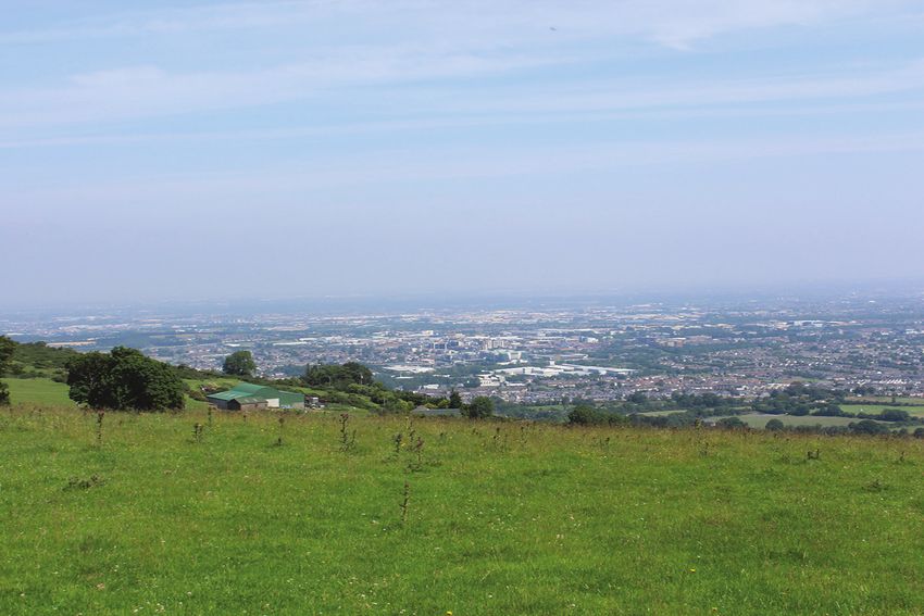
Sustainable Urban Drainage Systems (SuDS)
                                                                                                                                   GI4 Objective 2:
                            Natural features and open spaces such as parks or forests help retain and store
                                                                                                                                   To incorporate a SuDS management train during the design stage whereby
                            stormwater, slowing its infiltration into the water system and filtering pollutants.
                                                                                                                                   surface water is managed locally in small sub-catchments rather than being
                            However, due to reduced open space provision and higher rates of impermeable
                                                                                                                                   conveyed to and managed in large systems further down the catchment.
                            paving, urban areas can often experience challenges around surface water
                            management. Water is directed to grey infrastructure drainage systems that can                         GI4 Objective 3:
                            become overwhelmed during periods of heavy rainfall, leading to flooding. Pollutants                   To require multifunctional open space provision within new developments to
                            from the urban environment also flow into the water system unmitigated, potentially                    include provision for ecology and sustainable water management.
                            reducing overall water quality. The implementation of Sustainable Urban Drainage
                                                                                                                                   GI4 Objective 4:
                            Systems (SuDS) is a nature-based solution to water management that aims to
                                                                                                                                   To require that all SuDS measures are completed to a taking in charge
                            address these issues in a sustainable manner, by utilizing and mimicking natural
                                                                                                                                   standard.
                            infiltration processes from the environment.
                                                                                                                                   GI4 Objective 5:
                            The SuDS philosophy is to mimic the natural hydrological cycle by promoting;                           To promote SuDS features as part of the greening of urban and rural streets to
                            infiltration, evaporation, evapotranspiration, the harvesting of rainwater at source and               restrict or delay runoff from streets entering the storm drainage network.
                            the temporary storage of water (ponding), through the construction of a combination
                                                                                                                                   GI4 Objective 6:
                            or series of components to form a ‘management train’ The three ‘pillars’ of
                                                                                                                                   To maintain and enhance existing surface water drainage systems in the County
                            sustainable stormwater management practice are generally accepted as;
                                                                                                                                   and promote and facilitate the development of Sustainable Urban Drainage
                                                                                                                                   Systems (SUDS), including integrated constructed wetlands, at a local, district
                                   (i) Reducing the rate and quantity of stormwater discharge,
                                                                                                                                   and County level, to control surface water outfall and protect water quality.
                                   (ii) Improve the quality of stormwater discharges and receiving water bodies; and
                                   (iii) Provide amenity and biodiversity value. Consideration of the sensitivity of the
                                   		 surrounding environment and downstream water quality is fundamental to the             4.2.3 Climate Resilience
                                   		 successful implementation of SUDS systems, particularly as we face into the
                                   		 uncertainties of a changing climate.                                                   ‘Resilience’ is the ability to react and recover from external shocks and disruptions, as
                                                                                                                             well as the foresight to anticipate and proactively prepare for future challenges.
                            Guidance on the design, criteria and implementation of SuDS was produced under                   Climate change is recognised as a global source of disruption, one that will influence
Green Infrastructure (GI)

                                                                                                                                                                                                                           Green Infrastructure (GI)
                            the Greater Dublin Strategic Drainage Study (GDSDS). South Dublin County Council’s               Ireland’s spatial and economic growth and development over the next several
                            SuDS Guidance document will further inform developers and stakeholders in the                    decades. The Plan rises to this challenge and promotes a GI approach which
                            implementation of SuDS. SuDS measures suitable for the public realm and communal                 frontloads South Dublin County’s response to ensure a county which is resilient to
                            areas include ponds and wetlands, bioswales and urban trees. Through careful design              current and future climate change impacts.
                            such features can help enhance the streetscape. Localised site-specific measures
                            include the provision of green roofs/walls, filter strips, rain gardens, water butts and         The impacts of a changing climate include fluctuations in seasonal temperatures,
                            the incorporation of permeable paving where appropriate (see Appendix 4 and                      greater rainfall intensity and more frequent storm events, leading to an increased
                            Chapter 11 Infrastructure and Environmental Services and Chapter 13 Implementation               likelihood of flooding. Urban areas are particularly susceptible to these impacts.
                            and Monitoring).                                                                                 Built-up, three dimensional landscapes absorb and retain larger amounts of sunlight,
                                                                                                                             contributing to higher localised temperatures compared to rural areas. This is known
                                  Policy GI4: Sustainable Urban Drainage Systems                                             as the ‘Urban Heat Island’ effect, and can lead to higher cooling costs for buildings, as
                                                                                                                             well as cause discomfort for residents and visitors. Urban areas are also more
                                  Require the provision of Sustainable Urban Drainage Systems (SUDS) in the                  susceptible to intense rainfall and storm events which can overwhelm stormwater
                                  County and maximise the amenity and biodiversity value of these systems.                   drainage systems.
                                  GI4 Objective 1:
                                  To limit surface water run-off from new developments through the use of                    GI will play a key role in combating climate change and mitigating against its impacts.
                                  Sustainable Urban Drainage Systems (SuDS) using surface water and nature-                  The County’s trees, forest and park areas provide valuable carbon sequestration
                                  based solutions and ensure that SuDS is integrated into all new development in             services, absorbing CO2 from the atmosphere and storing it in the soil. In urban areas
                                  the County and designed in accordance with South Dublin County Council’s                   tree planting and other local GI interventions provide cooling and shade, ensuring a
                                  Sustainable Drainage Systems (SuDS) Explanatory, Design and Evaluation                     liveable and comfortable environment for residents and visitors. GI planting and SuDS
                                  Guide.                                                                                     can also play a significant role in stormwater runoff.

                            142                                       DRAFT SOUTH DUBLIN COUNTY DEVELOPMENT PLAN 2022-2028   DRAFT SOUTH DUBLIN COUNTY DEVELOPMENT PLAN 2022-2028                                    143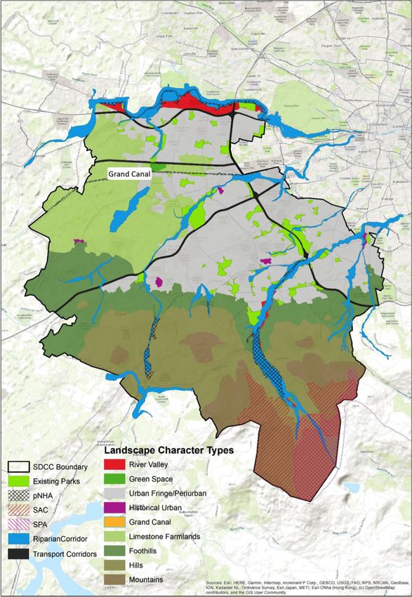
Urban Greening                                                                                 lifetime of the Development Plan. Where considered appropriate objectives
                            Interventions which modify the quality, quantity and accessibility of urban green              supporting additional planting are included in the relevant neighbourhood areas
                            spaces is described as Urban Greening. Urban Greening can be achieved by                       (refer to Chapter 12, Our Neighbourhoods).
                            establishing new urban spaces or by changing the characteristics of existing ones.
                            The process can refer to a broad spectrum of measures which can be implemented at
                            different scales in private or public spaces. These can include, pocket parks, urban
                            gardens, green roofs/walls, recreational and urban/community gardening and may
                            include facilitated access to urban woodlands, forests and natural wildlife areas.
                            Urban greening helps combat air and noise pollution, soaks up rainwater that may
                            otherwise create flooding, creates a habitat for local wildlife, and has shown to lift
                            morale in the people who see it, calming traffic and there is some evidence that it can
                            lessen urban crime.

                            Urban Greening is often implemented through the development of an Urban Greening
                            Factor (UGF). This is a tool that evaluates and quantifies the amount and quality of
                            urban greening that a scheme provides to inform decisions about appropriate levels
                            of greening in new developments. It should be based on a range of agreed factors
                            which contribute to greening of an area for example green roof/wall, tree planting,
                            provision of semi-natural vegetation, provision of wildflower meadows, water
                            features, hedge and tree planting etc. The output for a particular development would
                            be the achievement of a target score based on assigned scores to agreed
                            interventions.

                                  A Green roof is one which is planted with different types of vegetation, which
                                  can include grasses, flora, herbs and vegetables. Green roofs can be incorporated
                                  into new developments and retroactively installed on older buildings in order to
Green Infrastructure (GI)

                                                                                                                                                                                                                    Green Infrastructure (GI)
                                  secure a variety of benefits. They can contribute to climate change resilience,
                                  helping to improve air quality and temperature while also retaining and filtering
                                  stormwater to alleviate pressure on drainage infrastructure. Depending on the
                                  mix of plants used green roofs can also help contribute to local biodiversity, as
                                  well as provide new public and private amenity spaces and increase property
                                  values. Green walls can provide similar benefits and contribute to urban design
                                  and placemaking.

                            Tree Planting
                            The value of trees in delivering carbon sequestration is undisputed. Tree canopy               Figure 4.1: Tree Canopy Cover South Dublin County Council (Source: Department of
                            cover in the County has been assessed based on data provided by UCD, see Figure                Geography, UCD 2017)
                            4.1. It is highly desirable that the extent of this canopy should be extended during the

                            144                                     DRAFT SOUTH DUBLIN COUNTY DEVELOPMENT PLAN 2022-2028   DRAFT SOUTH DUBLIN COUNTY DEVELOPMENT PLAN 2022-2028                               145
Policy GI5: Climate Resilience                                                                   GI5 Objective 6:
                                  Strengthen the County’s GI in both urban and rural areas to improve resilience                   To provide more tree cover across the county, in particular to areas that are
                                  against future shocks and disruptions arising from a changing climate.                           lacking trees.

                                  GI5 Objective 1:                                                                                 GI5 Objective 7:
                                  Protect and enhance the rich biodiversity and ecosystems in accordance with                      Require the provision of green roofs and green walls, providing benefits for
                                  the ecosystem services approach to development enabling mitigation of                            biodiversity and as an integrated part of Sustainable Drainage Systems (SuDS)
                                  climate change impacts, by absorbing excess flood water, providing a buffer                      and Green Infrastructure, in apartment, commercial, leisure and educational
                                  against extreme weather events, absorbing carbon emissions and filtering                         buildings, wherever possible and develop an evidence base for specific green
                                  pollution.                                                                                       roof requirements as part of the Council’s ongoing SuDs strategy development.

                                  GI5 Objective 2:
                                                                                                                             4.2.4 Recreation and Amenity (Human Health and Wellbeing)
                                  To protect and enhance the natural regime of the watercourses of the County
                                  to more efficiently capture their flood resilience value.
                                                                                                                             There is a clear understanding that access to nature and the outdoors has a positive
                                  GI5 Objective 3:                                                                           impact on human health and wellbeing. This comes at the same time as an increased
                                  To ensure compliance with the South Dublin Climate Change Action Plan and                  awareness of the impact of air pollution on human health, which can lead to a myriad
                                  the provisions of the Council’s Tree Management Strategy.                                  of negative outcomes. A GI approach to planning maximises the benefits to humans
                                                                                                                             from healthy functioning ecosystems. To remain healthy and to continue to offer
                                  àà Increase the County’s tree canopy cover by promoting annual planting,                   benefit to humans, the integrity and biodiversity value of ecosystems must be
                                       maintenance preservation and enhancement of trees, woodlands and                      protected.
                                       hedgerows within the County using locally native species and supporting
                                       their integration into new development.                                               South Dublin’s GI network makes a vital contribution to the mental and physical
                                  àà   Identify suitable sites for new urban trees including Miyawaki style mini             health of our communities. The County’s hierarchy of publicly owned and managed
                                       woodlands, where feasible.                                                            parks and open spaces are important recreational destinations for residents and
                                  àà   Support the implementation of a co-ordinated regional approach to the                 visitors at the local, neighbourhood and regional level. The Dublin Mountains are a
                                       maintenance of trees and support the work of the Regional Steering Group              significant recreational attraction and are popular destinations for hiking, climbing
Green Infrastructure (GI)

                                                                                                                                                                                                                         Green Infrastructure (GI)
                                       on Tree Management to which South Dublin County Council is a participant.             and bike riding. Many of these open spaces serve as important hotspots for
                                  àà   Promote the establishment of tree trails in public parks across the County.           biodiversity, and the trees, forestry and woodlands they contain filter carbon and
                                  àà   Promote the planting of new woodlands and forestry within appropriate                 other pollutants, contributing to air quality. Over the period of this plan the Council
                                       open space and park locations within the County.                                      will preserve these existing recreational opportunities and support new projects and
                                  àà   To plant “pocket forests” in tracts of open grassland to act as an oasis for          innovations, such as the Dodder Greenway, that will further enhance and diversify the
                                       biodiversity.                                                                         ways in which residents and visitors can access and enjoy nature in the County.
                                  àà   The Council recognises the value of mature trees in terms of carbon
                                       sequestration and amenity over saplings.                                              A collaborative project with Dun Laoghaire Rathdown County Council, Dublin City
                                                                                                                             Council and the National Transport Authority, the Dodder Greenway will be over 17km
                                                                                                                             long, providing an integrated pedestrian and cycle route from the quays in Dublin
                                  GI5 Objective 4:
                                                                                                                             City Centre to Glenasmole in the foothills of the Dublin Mountains. This significant
                                  To implement an urban greening factor for all new developments subject to an
                                                                                                                             infrastructure will be integrated within the existing park system in order to provide
                                  appropriate scoring mechanism being developed for the County based on best
                                                                                                                             safe and attractive access throughout to open space throughout the County. A
                                  international standards and its appropriate application to the unique features
                                                                                                                             similarly forward-looking approach will be used to identify and promote new
                                  of the County. Developers will be required to demonstrate how they have
                                                                                                                             opportunities to improve the amenity and function of the County’s GI network. The
                                  achieved urban greening targets based on the scoring mechanism developed
                                                                                                                             Council will support Coillte’s Dublin Mountains Conversion Plan that seeks to convert
                                  through relevant interventions as part of the proposed development. (See
                                                                                                                             commercial forests in the Dublin Mountains to native and mixed woodlands to
                                  Chapter 13 Implementation and Monitoring).
                                                                                                                             improve their biodiversity value and recreational amenity. There is also an opportunity
                                  GI5 Objective 5:                                                                           to examine the various sports and leisure facilities that are located throughout the
                                  To promote positive land and soil protection measures to avoid degradation or              County, including playing pitches, skateparks and water sports, to review and assess
                                  loss of natural soil resources, to minimise sealing of soils and to remediate              how appropriate GI interventions can further improve their function and accessibility.
                                  contaminated land.

                            146                                       DRAFT SOUTH DUBLIN COUNTY DEVELOPMENT PLAN 2022-2028   DRAFT SOUTH DUBLIN COUNTY DEVELOPMENT PLAN 2022-2028                                  147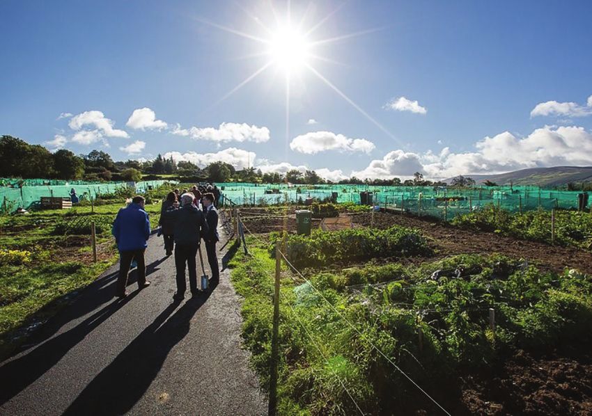
Innovative design solutions can help integrate traditionally hard-landscaped
Policy GI6: Human Health and Wellbeing
recreational facilities, such as playgrounds and skateparks, into the local GI network.
Doing so can diversify the uses of these spaces, while also contributing to stormwater Improve the accessibility and recreational amenity of the County’s GI in order to
management. Weaver Park in Dublin City’s Liberties area combines the provision of a enhance human health and wellbeing while protecting the natural environment
skatepark with lawns and tree planting to create a multifunctional outdoor space that within which the recreation occurs.
can host active and passive recreational uses, as well as markets or outdoor
GI6 Objective 1:
exhibitions. As a European example, the Lemvig Skatepark in Denmark transforms the
To support a hierarchy of accessible open spaces and recreational facilities,
idea of a mono-functional skate park into a multifunctional recreational space. The
appropriate for neighbourhood size and catchment area, which are adaptable
paved skate area is interspersed with grassy planted areas, as well as a small
and capable of accommodating multiple uses (See Chapter 8 Community and
basketball court and sandpit, providing discrete yet interconnected spaces where
Public Open Space).
families and visitors of all ages can play and relax.
GI6 Objective 2:
To maximise the leisure and amenity resource offered by the County’s parks
The Council manages allotments at Tymon Park in Tallaght, Corkagh Park in
through the promotion of Management Plans that provide for the continued
Clondalkin, Friarstown in Bohernabreena and Mill Lane in Palmerstown. Residents
improvement of the park setting, biodiversity and recreational facilities.
can pay to rent these allotments to grow their own fruits and vegetables,
providing access to healthy affordable food. Allotment growing also provides an GI6 Objective 3:
opportunity for healthy physical recreation and social engagement, and also can To provide accessible, attractive and safe routes linking settlements to the GI
play an important role in improving local biodiversity. The Council will continue network of the County.
to protect and promote these existing and provide for new allotments in
accordance with a review of the provision and management of allotments across GI6 Objective 4:
the County. To ensure that all new residential development provides access to
multifunctional green open space, in accordance with the provisions of Chapter
8 Community and Public Open Space of this Development Plan and South
Dublin County’s Parks and Open Space Strategy.
GI6 Objective 5:
To support the provision of new walkways and cycleways in suitable locations
Green Infrastructure (GI)
Green Infrastructure (GI)
to improve the recreational amenity of GI corridors in a manner that does not
compromise the ecological functions of the corridors.
GI6 Objective 6:
To minimise the environmental impact of external lighting within the GI
network to achieve a sustainable balance between the recreational needs of an
area, the safety of walking and cycling routes and the protection of light
sensitive species such as bats (See Chapter 3 Natural, Cultural and Built
Heritage).
GI6 Objective 7:
To enhance publicly owned open spaces with further appropriate GI including
nature-based interventions to improve and diversify the services they provide.
GI6 Objective 8:
To support, in agreement with the delivery authority, the provision of outdoor
public water drinking fountains along all new and future dedicated cycleways,
promoting reusables and actively incentivising transition from single use
plastic.
GI6 Objective 9:
To investigate the potential to plant hedgerows along roads to help mitigate
noise and air pollution, and to increase visual amenity and enhance biodiversity.
148 DRAFT SOUTH DUBLIN COUNTY DEVELOPMENT PLAN 2022-2028 DRAFT SOUTH DUBLIN COUNTY DEVELOPMENT PLAN 2022-2028 149GI6 Objective 10: Policy GI7: Landscape, Natural, Cultural and Built Heritage
To continue to protect and promote existing allotments and provide for new Protect, conserve and enhance landscape, natural, cultural and built heritage
allotments where feasible in accordance with a review of the provision and features, and support the objectives and actions of the County Heritage Plan.
management of allotments across the County.
GI7 Objective 1:
To protect, conserve and enhance natural, built and cultural heritage features
4.2.5 Landscape, Natural, Cultural and Built Heritage
and restrict development that would have a negative impact on these assets in
accordance with the provisions of Chapter 3 Natural, Cultural and Built
Natural, cultural and built heritage is concerned with the range of natural and man-
Heritage of this Development Plan.
made assets of heritage value in the County. These include areas of importance for
biodiversity, such as watercourses, woodlands and cultural assets such as important GI7 Objective 2:
monuments, buildings and landscapes. To protect and enhance the landscape character of the County by ensuring
that development retains, protects and, where necessary, enhances the
Natural heritage plays an important role in defining the character of South Dublin. appearance and character of the landscape, in accordance with the provisions
The County contains a diverse range of landscapes that are both important of South Dublin’s Landscape Character Assessment and the provisions of
ecological habitats as well as areas of natural beauty. The foothills of the Dublin Chapter 3 Natural, Cultural and Built Heritage of this Development Plan.
Mountains, the river valleys of the Dodder and the Liffey and the Grand Canal are part
GI7 Objective 3:
of South Dublin’s natural, cultural and built context and contribute to the County’s
To work in collaboration with the owners of lands along the perimeter of
setting and character, as well providing important recreational uses for residents (See
Rathcoole Woodlands for its protection and that of the wildlife using it and the
Landscape Character Assessment, Appendix 9). The County’s heritage also presents
ecological services it provides.
an opportunity to attract more visitors and tourists to the area on account of its
amenity and beauty. The GI Strategy recognises the plurality of the values and aims GI7 Objective 4:To develop Rathcoole Woodlands as part of a wider nature/
to provide for the protection of South Dublin’s heritage while ensuring its sustainable walking trail from Saggart to Lugg Woods subject to the protection of its
management and utilisation. biodiversity, wildlife and ecological value which is of primary importance.
Natural, cultural and built heritage also contributes to placemaking at the local level. GI7 SLO 1:
People have a cultural and emotional attachment to their natural environment. It The current green wildlife corridor between Saggart and Rathcoole be
Green Infrastructure (GI)
Green Infrastructure (GI)
helps us interpret and connect with our communities and contributes to a sense of maintained and the need to preserve this wildlife corridor be incorporated into
place and community cohesion. Local heritage features, such as a small park, a the design and development plans for Rathcoole park.
collection of trees or even a line of hedgerow may not immediately appear to be CS10 SLO 1*:
important in the context of the wider County. Yet, such features help define our To investigate the potential for alternative land uses for the lands currently
communities and peoples experience within them. South Dublin’s GI network is zoned RES-N (To provide for new residential communities in accordance with
greater than the sum of its parts and local heritage contributes to a healthy County- approved area plans) and OS (To preserve and provide for open space and
wide GI network in which residents will be invested. recreational amenities) as identified by the SLO on the CDP land use zoning
map, having regard to protecting existing habitats, biodiversity and the
A key challenge for the Plan is to balance the protection of our heritage and Rathcoole woodlands, the need for social and affordable housing, community
landscapes with the management of change in a manner that enhances rather than infrastructure and access. Following this assessment, and where alternative
diminishes heritage and landscape features, structures, buildings, sites and places of land use arrangements are identified in line with the proper planning and
special interest. sustainable development of the area, to bring forward proposals for re-zoning.
*This SLO is repeated from the Core Strategy for ease of reference.
150 DRAFT SOUTH DUBLIN COUNTY DEVELOPMENT PLAN 2022-2028 DRAFT SOUTH DUBLIN COUNTY DEVELOPMENT PLAN 2022-2028 1514.3 Defining the Spatial Framework key corridors pass through the neighbouring administrative areas of Dún
Laoghaire–Rathdown, Dublin City, Kildare and Fingal. As such the GI Strategy will
The Council’s GI network has been identified and mapped as part of the development have regard to the need for cross-boundary communication and collaboration for
of this strategy. This mapping exercise has identified a spatial framework for the their effective management.
County’s GI comprising a diverse range of habitat and landscape types, from river
valleys and major parks to private gardens and urban green spaces and including The Strategic County GI Corridors are further supported by a number of Local GI
Natura 2000 sites and proposed NHAs. Other data sets have also informed the Corridors, as demonstrated in Figure 4.4. Each strategic corridor is described
strategy, including flood maps and riparian corridors. There are variations in the separately within Table 4.1, along with associated objectives. Appendix 4 provides
distribution and quality of GI across the County. However, the County’s GI assets further detail around the Local GI Corridors.
come together to create a complex, integrated network of components whose total
àà The County’s GI network contains a number of smaller, discrete green spaces that
value is greater than the sum of their parts.
are dispersed throughout its built-up area. These include local-scale greens and
parks and other green spaces. These spaces serve as Stepping Stones for species
4.3.1 Components of the GI Network
to move throughout the broader network of corridors and core areas and
contribute to a range of additional local benefits around recreation and
GI networks are spatially defined in terms of several common components. Core
stormwater management.
Areas serve as anchors within a GI network. They are the point of origin and
destination for wildlife and are sites at which essential ecological processes occur.
àà The urban centres and suburban areas of the County contain localised GI features
Corridors represent the physical links that tie the network of Core Areas together.
such including urban trees, smaller open spaces and water management features
They typically align with water courses or linear open spaces and allow for the
such as SuDS. The GI Strategy seeks to enhance such features and ensure they are
migration of species between Core habitats. Stepping Stones are smaller areas of
connected to the broader GI network.
green space. They provide alternative routes for the movement of species within the
overall network and contribute to local biodiversity. The spatial arrangement of these
This strategy seeks to ensure that all new development contributes to the overall GI
different components and their relationship to one another comprises a spatial GI
network of the County. It provides measures to protect and enhance existing GI
network. In the context of South Dublin County these Core Areas and Corridors
attributes in the County providing for connections to local Stepping Stones (creating
provide connections not just within the County itself but also to the adjoining Local
Stepping Stones) and ultimately providing links to the GI Corridors and Core areas of
Authorities of Dublin City Council, Fingal County Council, Wicklow County Council,
the County and Region. This contributes to strong climate change mitigation and
Green Infrastructure (GI)
Green Infrastructure (GI)
Kildare County Council and Dún Laoghaire–Rathdown County Council.
adaptation in South Dublin County allowing us to meet national and regional targets
referenced in section 4.0.1 above.
The key components and features of the County’s spatial GI framework are detailed
below:
or
k
àà Major Core Areas within the County include the Dublin Mountains and the parks rid
or
or
C
located along the Liffey Valley providing strong GI links with adjoining counties.
etw
Co
Other Core Areas include major parks and public green spaces, such as
rri
ts of GI N
do
Waterstown Park and Lucan Demesne within the Liffey Valley, and Tymon Park Core
r
and Corkagh Park. The Liffey Valley Special Amenity Order Area extends
protection within the Liffey Valley from Chapelizod to Lucan. These core areas are
important centres of biodiversity in their own right and also serve as important
recreational assets for South Dublin residents and visitors.
ponen
Core Stepping
àà A network of overlapping and multi-functional GI Corridors connects the County’s Stones
core areas with the Dublin Mountains, Liffey Valley, Kildare rural hinterland and the
m
broader regional GI network. These corridors largely comprise of watercourses
Co
and their associated riparian zones, such as the River Liffey, Dodder, and Camac Core
as well as the Grand Canal. Two additional emerging potential corridors along the
urban fringe have been identified, adjoining the boundary with County Kildare
(greenbelt/green space potential) and the M50 Corridor. Corridors also include
the extensive network of hedgerows and trees that exist across the County. The Figure 4.2: Components in a GI Network
152 DRAFT SOUTH DUBLIN COUNTY DEVELOPMENT PLAN 2022-2028 DRAFT SOUTH DUBLIN COUNTY DEVELOPMENT PLAN 2022-2028 153Green Infrastructure (GI)
Green Infrastructure (GI)
Figure 4.4: Green Infrastructure Strategy Map
Figure 4.3: Key Elements of South Dublin County Council’s GI network
154 DRAFT SOUTH DUBLIN COUNTY DEVELOPMENT PLAN 2022-2028 DRAFT SOUTH DUBLIN COUNTY DEVELOPMENT PLAN 2022-2028 1554.3.2 Strategic Corridor Objectives
Overarching Objectives:
Objectives for each of the six strategic corridors are set out below in Table 4.1.
àà To provide a multi-functional GI corridor crossing and connecting the
mountains, urban and rural areas and linking with other regional corridors.
Table 4.1 Strategic Green Infrastructure Corridors
àà To recognise, protect, and enhance the role of the River Dodder Corridor as
Strategic Corridor 1: The Dodder River a key route through the urban environment for biodiversity and protected
The River Dodder rises in the Dublin Mountains in the Glenasmole Valley and species.
flows north-eastwards through the administrative areas of South Dublin, DLR àà To protect and enhance the River Dodder Corridor as an area of heritage,
and Dublin City before entering the sea at the Grand Canal Basin in Ringsend. As geology, special amenity and recreation.
such, the Dodder presents a unique opportunity to connect South Dublin’s GI àà To monitor and address any negative impacts on biodiversity and protected
network with those of its neighbours. species arising from amenity and greenway activities, so as to maintain the
high value of the River Dodder Corridor as a Green Infrastructure link
The River Dodder has the unique characteristics of being both an urban river through the County and region.
within a capital city and an important GI corridor for biodiversity. The Dodder is àà To explore opportunities to restore the quality and biodiversity of the
a Strategic GI corridor at the regional level passing through three urban / Dodder’s river-bank margins.
suburban counties and linking to several Natura 2000 sites and links to the àà To enhance and maintain ecological habitats along the river corridor to
Dublin / Wicklow Mountains and the Irish Sea. The Dodder River is a strong improve mobility for protected species and to support other ecosystem
ecological corridor, containing a valuable biodiversity resource and acts as a services such as pollinator sites, flood attenuation, and spaces for low-
refuge and protection of biodiversity both in general, and especially, for a wide impact recreation.
range of protected species through the urban landscape – true ‘Green àà To continue the implementation of non-native invasive species control
Infrastructure’. In a European context, the presence of kingfishers, dippers. within the County including along the river Dodder, and to co-ordinate
otters, and lamprey along an urban river like the Dodder is a very unique control measures with other stakeholders, wherever possible, to ensure a
situation, especially for a capital city. collaborative approach.
àà To protect green and blue infrastructure of the Dodder river corridor and
There are substantial parks along the banks of the Dodder, providing amenity restore the naturalness of the rivers riparian buffer zones through the
and recreation for the population of the city. The more recent development of planting of native plant species while minimising new development within
Green Infrastructure (GI)
Green Infrastructure (GI)
the Dodder Greenway resulted from a collaboration between South Dublin, the riparian buffer areas (Riparian Buffer Zones are shown on GI Map
Dublin City and Dun Laoghaire Rathdown Councils. This project will see the accompanying the Development Plan).
creation of a 17km greenway linking the quays in Dublin City Centre to the àà To protect sensitive species within the Dodder Valley and ensure new
Bohernabreena Reservoir at Glenasmole. South Dublin are responsible for 14km recreational development within the Dodder Valley does not have an
of the greenway, from Bohernabreena Reservoir to Orwell Park in Rathfarnham. adverse impact on nocturnal species.
The Greenway will be utilised by pedestrians and cyclists. Planning for the àà To protect and enhance the outstanding landscape character and amenity
Greenway requires improvement of the environment through which it passes. of the Dodder Valley (See Chapter 3: Natural, Cultural and Built Heritage).
àà To restore the natural features of the River Dodder riparian buffer zone and
promote the planting of native plant species.
àà To implement the plans for the Dodder Greenway in accordance with the
Part 8 for the scheme.
156 DRAFT SOUTH DUBLIN COUNTY DEVELOPMENT PLAN 2022-2028 DRAFT SOUTH DUBLIN COUNTY DEVELOPMENT PLAN 2022-2028 157You can also read