DRAFT for Community Engagement - July/August 2021 - Whangarei District Council
←
→
Page content transcription
If your browser does not render page correctly, please read the page content below
DRAFT for Community Engagement
         July/August 2021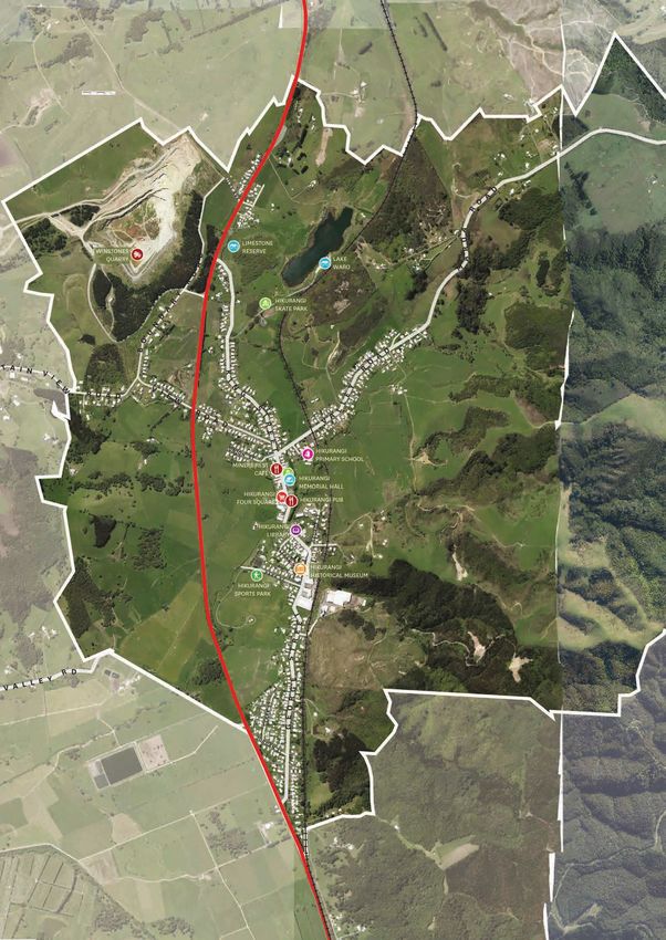
INTRODUCTION
                                                The Hikurangi Placemaking Plan is a response to
                                                the growth and changes that are happening in

    Hikurangi
                                                Hikurangi. The Hikurangi Placemaking Plan is a 20-
                                                30-year vision for how Hikurangi will change, grow
                                                and develop.

    PLAN IN BRIEF                                             By 2051, Hikurangi’s population
                                                              is estimated to grow from

    We are seeking feedback on the draft
                                                              3,313 to 5,017
    Hikurangi Placemaking Plan. Does the                      By 2051, Hikurangi’s dwellings
    Hikurangi Placemaking Plan reflect your                   are estimated to grow from
    future vision for the area? Are we on the
    right track? Are we missing anything?
                                                              1,216 to 1,937

    Tell us what you think at                                                               3
                                                   The Hikurangi Placemaking Plan contains key
    www.wdc.govt.nz/Placemaking                         outcomes,   4 Areas of focus, 41 Actions
                                                                         and a community toolkit
    Hikurangi has been identified as a
    moderate growth node within
    the Whangārei Growth
    Strategy.

       Hikurangi
       (Moderate Growth
       Area)
       Tutukākā Coast

       High Growth

       Moderate Growth

2
3 KEY OUTCOMES 41 ACTIONS
          Connectivity
          Hikurangi will be a walkable, safe,                 9 Ongoing/Funded Actions
                                                              9 Planned Actions
          legible and accessible place with strong
          connections to Whangārei City Centre, the
          Tutukaka Coast and Glenbervie Forest.

          Heritage and Character                             14 Strategic Actions
          Hikurangi will be celebrated for its
          distinctive Heritage, Character, Culture
          and Environment.
                                                              9 Development Guidance
                                                         Actions are structured around who leads/drives
          Destination                                    them:
          Hikurangi will be considered a unique and
          vibrant destination for future residents and
          visitors.

                                                           Whangārei         Community or      Developers

4AREAS OF FOCUS
                                                         District Council     Community        or Private
                                                             (or other          Groups           Sector
                                                            Agencies)

Hikurangi Village Centre                                 ONGOING / FUNDED
Improve and uplift the profile, appearance and
connectivity of the main streets of Hikurangi
Village to celebrate its unique character, promote
                                                         ACTIONS
activity and walkability.                                •   Footpath improvements within the Hikurangi
                                                             Village.
Hikurangi Sports Hub                                     •   Identification of heritage buildings and
Improve the connectivity and usability of the                character assessments.
Hikurangi Sports park and the multiple sporting
                                                         •   Work with community and Northland inc. to
facilities in the direct area.
                                                             develop a Hikurangi Heritage trail.
Lake Waro                                                •   Hikurangi Sports Hub user forum and master
Uplift the Lake Waro area as a key feature and               plan.
amenity within Hikurangi. Continue to develop the        •   Improvement of Lake Waro facilities.
area as a key amenity, building on the facilities and
improving access and connectivity                        •   Hikurangi Skate Park upgrade.
                                                         •   Work with community and Northland inc.
SH1 Connections                                              to promote and market Hikurangi as a
Improve connectivity and safety between                      destination.
Hikurangi village and SH1. Support the community         •   Work with hapū to improve environmental
to enhance Hikurangi’s profile as a destination              outcomes of the Hikurangi Wairepo/Swamp.
through marketing and wayfinding.
                                                         •   Riparian and community planting.

                                                                                                            3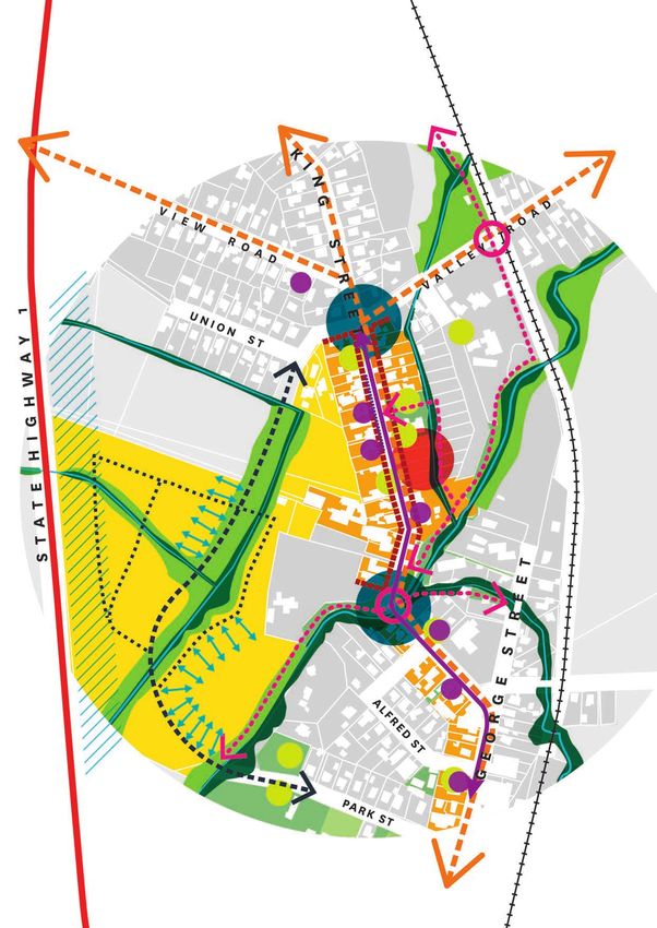
Contents Page
    02 Placemaking Hikurangi - Plan in Brief      46 Area of Focus 2
                                                  46 Hikurangi Sports Hub
    04 Contents Page                              48 Actions
    05 Background
                                                  50 Area of Focus 3
    06   Placemaking Plans                        50 Lake Waro Destination
    06   What is the Placemaking Programme?       52 Actions
    06   Why are we creating Placemaking Plans?
    07   Growth and Wellbeing                     54 Area of Focus 4
    08   Placemaking Strategic Drivers            54 SH1 Connection and Safety
    09   Where does this plan fit in?             56 Actions
    10   Future Placemaking Plans
    10   Developing the Plan                      60 Other Actions

    12 Hikurangi Placemaking Plan                 64    Community Toolkit
    12 Community Engagement                       64    What we do
    12 Engagement with Tangata Whenua             65    Engaging with your council
                                                  66    Forms of support available
    15   Location and Context                     66    Customer Service
    19   Current Growth                           67    What is the Long-Term Plan?
    21   Growth Considerations and Hazards        67    Community Development
    22   Infrastructure and Transport             69    Events
    25   Connectivity and Walkability             70    Planning and Development
    27   Future Growth                             71   Community Gardens
    29   Infrastructure Capacity                  72    District Promotion
    31   Qualities and Characteristics            73    List of other key organisations
    33   Issues and Opportunities                 77    Key community contacts

    34 Key Outcomes

    36 Hikurangi Placemaking Plan Actions
    38 Areas of Focus

    40 Area of Focus 1
    40 Hikurangi Village Centre
    42 Actions

4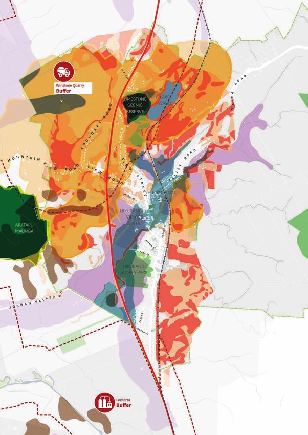
Background
       Whangārei is growing and developing but there is a gap when it
       comes to understanding how this affects specific locations in our
       District.
       A key response within the Whangārei District Growth Strategy is to undertake a
       Placemaking Programme. The Placemaking Programme will create a series of spatial
       plans for our Districts communities and look at how they will change, grow and develop
       over the next 20-30 years.

       The Placemaking Programme was adopted by Whangārei District Council in February
       2020 and began in the communities of Tikipunga and Hikurangi.

Engagement
We are seeking feedback on the draft Hikurangi Placemaking Plan. Does the Hikurangi
Placemaking Plan reflect your future vision for the area? Are we on the right track? Are
we missing anything? Tell us what you think at www.wdc.govt.nz/Placemaking or
contact us at placemaking@wdc.govt.nz.

We began the process of developing the Hikurangi Placemaking Plan we set out to develop a shared vision
between Whangārei District Council, the community, hapū and key stakeholders.

Engagement was very important to us from the outset but was interrupted in 2020 by COVID-19 and the
continuous risk of potential lockdowns and government mandated level changes. It led to a more adaptable
and flexible approach to our engagement, using more online tools as well as face-to-face engagement.

We have conducted a total of two rounds of community engagement and, with this plan, are now undertaking
the third. To date, there have been 191 responses online as well as community workshops and drop in
sessions held in Hikurangi. We have also conducted more targeted engagement with hapū and hapori Māori
in Hikurangi.

Community feedback received indicated to us what place-specific outcomes and issues the community
wanted the Hikurangi Placemaking Plan to focus on:
•      Connectivity
•      Heritage & Character
•      Destination

                                                                                                           5
Placemaking
                     Plans
    What is the Placemaking Programme?
    The Placemaking Programme is a response to the growth and changes that are happening in the Whangārei
    District. While we have often planned for growth at a District level, what has been missing is the understanding
    of what this growth means for individual communities and neighbourhoods. A ‘one size fits all’ approach is
    not the best way forward for our diverse District because each place is different. Communities have their
    own set of qualities, unique characteristics and people who make them special.

    The Placemaking Programme will create a series of 20-30-year place-based, spatial plans for how a specific
    community will change and grow and identify the key challenges and opportunities that come with it.

    Why are we creating Placemaking Plans?
    Whangārei is growing and developing but there is a gap when it comes to understanding how this
    affects specific locations in our District.

6
Growth and Wellbeing
Central government direction is ensuring that the    connected, have a high standard of amenity and can
way our communities grow and develop is not just     easily access services such as education, health and
about the number of homes that can be built. It      public open spaces.
recognises the importance of amenity, connectivity
and access to services. The Placemaking Plans seek   Policy 1 from the National Policy Statement on Urban
to achieve the same outcomes.                        Development provides a framework which has
                                                     driven the outcomes and actions of the Placemaking
As these places grow, we need to plan ahead and      Plans.
ensure existing and future communities are well

    Planning decisions contribute to well-functioning urban environments, which are
    urban environments that, as a minimum:
                       A. have or enable a variety of homes that:
                          i. meet the needs, in terms of type, price, and location, of different
                              households; and
                          ii. enable Māori to express their cultural traditions and norms; and

                       B. have or enable a variety of sites that are suitable for different
                          business sectors in terms of location and site size; and

                       C. have good accessibility for all people between housing,
                          jobs, community services, natural spaces, and open spaces,
                          including by way of public or active transport; and

                       D. support, and limit as much as possible adverse impacts on,
                          the competitive operation of land and development markets;
                          and

                       E. support reductions in greenhouse gas emissions; and

                       F. are resilient to the likely current and future effects of climate
                          change.

                                                                                                            7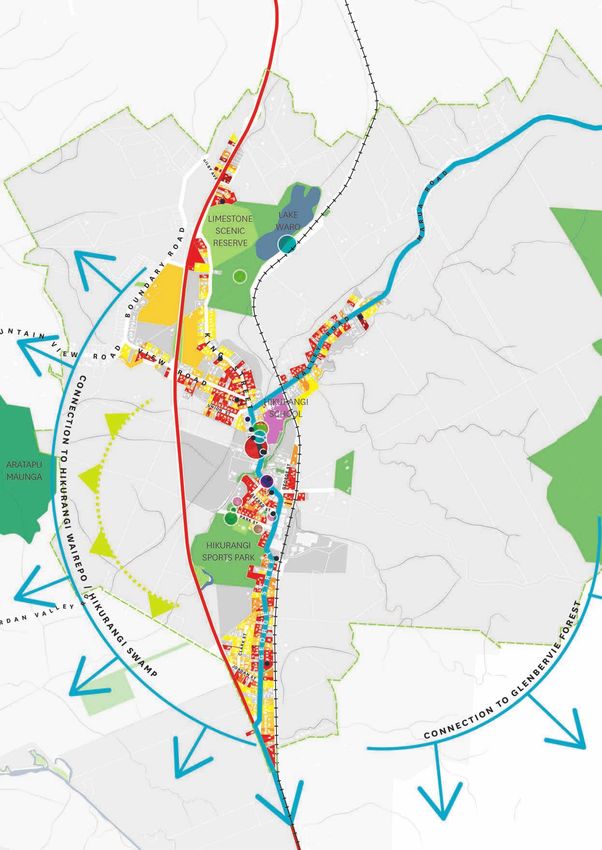
Placemaking
                     Plans
    What is the Placemaking Programme?
    The Hikurangi Placemaking Plan has
    been driven by:

    Each Placemaking Plan will identify actions which will feed into the district plan review process, the capital
    works, infrastructure, and transport programmes, and align their actions with the Long-Term Plan and
    annual plan funding. They will also act as a tool for communities providing a vehicle for community input
    into planning and development decisions

8
Where does this plan fit in?
The Placemaking Programme is a series of non-statutory plans which look at growth and the management of
growth at a place-specific level. It is a strategic programme which has come from our overarching Whangārei
District Growth Strategy and sits alongside our Whangārei City Centre Planning work.

The plans are intended to be integrated, tying together the various council tools in planning, infrastructure,
transport and regulatory to ensure council departments are working towards the same outcomes for our
communities.

                                                                                                                 9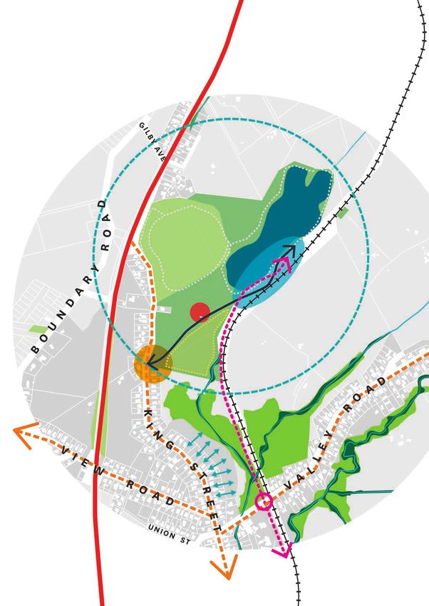
Placemaking
                      Plans
     Future Placemaking Plans
     Council have set the prioritisation of the Placemaking Plans. It is envisioned that each plan will take 12
     months and more than one plan can be worked on at any one time:

                                            Placemaking Programme

     This list may be added to in the future or locations may be reprioritised subject to elected members approval.
     In particular, the Marsden/Ruakaka plan may be worked through separately as part of the Northland to
     Auckland Corridor Plan.

     Developing the Plan
     The Hikurangi Placemaking Plan has been developed using a three-stage process:
     • Stage 1: Set Direction
     • Stage 2: Testing and Developing
     • Stage 3: Final Plan

     The Hikurangi Placemaking Plan was developed alongside the Tikipunga Placemaking Plan and included
     internal workshops, discussions with external and central government stakeholders as well as three rounds
     of community engagement. The plan development process and key council and community milestones are
     outlined in the diagram on the following page.

     The aim is to have the Placemaking Plans adopted by Whangārei District Council on 23rd September 2021.

10
11
Hikurangi
                     Placemaking Plan

     Community Engagement
     The Hikurangi Placemaking Plan was put together         with the Hikurangi Placemaking Plan. This led us
     by Council alongside the community, tangata             to focus a lot of engagement online, something we
     whenua, hapū and key stakeholders to build a            continued to do throughout the process.
     shared future vision for Hikurangi which is inclusive
     and meaningful.                                         The development of the pilot Placemaking Plans
                                                             also helped us to understand the importance of
     Throughout the development of this plan, ongoing        building relationships with key community groups
     collaboration with internal staff and the community     and individuals within the community early in
     has guided the plan development process. This was       the plan making process. From the outset, we
     a new approach to our plan development and will         have worked alongside the Hikurangi Business
     be used to inform engagement as we develop future       Association, Hikurangi Friendship House and other
     Placemaking Plans.                                      key community groups. This led to the formation
                                                             of the Hikurangi Placemaking Plan Steering Group,
     Engagement within the early stages of the plan          a community led group which we engaged with
     development were interrupted by COVID-19                regularly throughout the development of the
     restrictions. Within our engagement we aimed to be      plans. The energy from this group and the wider
     flexible, adaptable and creative to ensure we gained    community was a key strength to the development
     the best possible outcomes for the communities          of this plan.
     we were working with, while continuing to progress

     Engagement with Tangata Whenua
     As we moved into the development of the draft Hikurangi Placemaking Plan we wanted to establish a more
     robust and inclusive approach to engagement with hapū to ensure their aspirations and priorities were
     captured within these plans. Following the first and second round of engagement council felt we had not
     been successful in capturing the Maori voice and wanted the opportunity to work in partnership with hapū
     to encourage participation within the development of these plans and future Placemaking Plans.

     We worked with Te Huinga to ensure we engaged appropriately with hapū. We also engaged an external
     consultant to assist us in this process. A roopu kaumatua was formed to advise council and the consultant
     in the development of the Hikurangi Placemaking Plan Whakaaro Ahurea Report. Recommendations were
     made as part of this report and more work needs to be done to ensure these are embedded into the actions
     of the Hikurangi Placemaking Plan or inform other council work programmes.

     Through the development of these plans we have created a clear process and methodology which we
     hope to continue to use through the development of other Placemaking Plans and strategic documents.
     Engagement with tangata whenua will begin at the outset of future Placemaking Plans.

12
June / July 2020 October / November 2020 July / August 2021
The purpose of the first round of The purpose of the second round The purpose of the third round
community engagement was to: of community engagement was round of community engagement
• educate the public about the to: was to:
Placemaking Programme • identify opportunities as well • seek feedback on the final
• gain an understanding of as test our own learnings draft plan to ensure we are
Hikurangi and what matters and analysis from internal heading in the right direction.
most to the community. discussions and the first
round of engagement.
Online Survey Online Survey
140
Responses
51Responses
Due to COVID-19 restrictions, PLACEHOLDER
our engagement was limited Community Response to third
to online platforms and tools. Workshop
30
round of community
We asked people to tell us what
they think the qualities, issues engagement
Attendees
and opportunities are within
Hikurangi.
Drop-in
We also used it as an opportunity Sessions
to acknowledge the context of
COVID-19 and how it has affected 4 Sessions
people and their feelings towards
their local neighbourhoods.
1314
Hikurangi
                Location and Context

                                                                   Hikurangi
                                                                   (Moderate Growth Area)

                                                                   Tutukākā Coast

                                                                   High Growth

                                                                   Moderate Growth

Hikurangi is a settlement located 16km north of
Whangārei. It is the District’s northern gateway
to Whangārei and the Tutukaka Coast. It is an
important service centre to the wider community
and local agricultural industry. The township was
built around the mining of coal and limestone
resources beginning in the late nineteenth
century. Its mining history has strongly influenced
Hikurangi’s settlement pattern and character.
This character is reinforced by the strong sense of
community and the friendly and diverse people
living and working in Hikurangi.

Hikurangi’s population over the past 20 years has
remained constant at around 1600-1700 people.
Although the population has remained stable,
Hikurangi has the potential to be a key growth area
for the north of the District.
                                                      *Estimated Residential Population
                                                                                            15
Map Key
School
Playground
Sports / Recreation
Community Halls
Commercial
Study
Library
Cafe/Restaurant
area
Scenic Locations
Industry
Museum
16Hikurangi
Location and Context
The Hikurangi village is primarily a residential area and is the northern most settlement in Whangārei. The
commercial area is centred around the four square, the Hikurangi pub, and many other long-standing
businesses. There are also a number of community operated facilities such as Hikurangi Memorial Hall,
Hikurangi Historic Museum and the Hikurangi Library. The Hikurangi Sports Park is also well used and
a prominent event and social space within the community. Another key feature is Lake Waro and the
Limestone Scenic Reserve located at the Northern end of
Hikurangi Village.
Although the focus has been on the Hikurangi
Village Centre, as shown in the map, we
wanted to acknowledge the connections
Hikurangi has to the wider rural and coastal
areas.
It was important that while the
scope of the plan was centred
around the Hikurangi Village,
the surrounding rural and
coastal areas were considered
in the development of the plan.
*Data Hikurangi
Springs Flat StatsNZ
Area Unit
*Estimated
Residential Population
* Stats NZ Census Data 2018
1718
Hikurangi
                Current Growth
The growth that we are facing within the Whangārei District is largely driven by people moving to Whangārei,
rather than a natural increase in our existing population. As a moderate growth area, Hikurangi has only seen a
small portion of this growth. However, it has a lot more potential for growth and development.
    As Hikurangi grows it is important to consider the following issues:
    • Avoiding sprawl and focus development in and around the Hikurangi village area.
    •   Consider access and means of travel to employment opportunities both within Hikurangi and in
        and around Whangārei City Centre.
    •   Investing in core infrastructure to keep up with demand as well as identifying now the big projects
        we will need in the future
    •   Aligning growth with transport services including public transport and walking/cycling
        opportunities
    •   Considering our strategic partnerships and the role of central government in supporting
        development.

                                             * Tech One Extract / LINZ Survey Plans Analysis

            Map Key
                State Highway 1
                                                                                               Building Consents
                                                 Rural Village zoned land
                Railway Line
                                                                                               Commercial Centres
                                                 Subdivision 2 lots
                Rivers & Streams
                                                 Subdivision 3 - 5 lots                        Employment Nodes
                Council Green Space
                                                 Subdivision 6 - 10 lots                       Journey to Work
                Other Green Space

                                                                                                                    19
20
Hikurangi
         Growth Considerations and Hazards
Our District has varied ground and climatic conditions. In Hikurangi, there are areas susceptible
to hazards. Hazards create risks to human health and safety, and threaten property. These risks
can be exacerbated by land use activities such as earthworks, building, excavation, and vegetation
clearance. Development within hazard areas is discouraged and rules and controls for land use
activities in these areas are within the Whangārei District Plan.

In addition, it is important to consider features which require protection from development such
as outstanding natural landscapes and features, areas of importance, and productive soils. In the
wider Hikurangi area buffers are identified to protect existing industry, namely Fonterra and the
Winstone quarry to ensure they can operate effectively, and reverse sensitivity issues are managed.

When accommodating growth in Hikurangi we need to consider the risks from natural hazards and
avoid where practicable the risks or adverse effects to the environment, people and property.

                                Map Key

                                     State Highway 1
                                                                 Industry Buffers
                                     Railway Line                        Dicksons Quarry
                                     Rivers & Streams                    Fonterra

                                     Council Green Space
                                                                         Industry Buffer
                                     Other Green Space

                                                                  Natural features and
                               Hazards
                                                                  areas of importance
                                     Flood Prone Land                    Protected Natural Area
                                                                         Programme (PNAP)
                                     Land Instability -
                                     Medium Risk                         Outstanding Natural
                                                                         Landscape
                                     Land Instability -
                                     High Risk                           Outstanding Natural
                                                                         Feature
                                     Mining Hazard
                                                                         Productive soils

                                                                                                      21
Hikurangi
Infrastructure & Transport
Infrastructure is important and supports what we early childhood education centres, one medical
do in our daily lives: the water we drink, the parks centre and two community buildings. Residents
that we play in and the way we get around. The within the rural village and rural residential zones
quality of the environment and the wellbeing of are currently serviced by the three waters core
communities are affected by choices about the infrastructure.
management of, and investment in, infrastructure.
As Hikurangi grows, we need to ensure that
infrastructure is provided in a co-ordinated manner
to service not just the village, but the wider rural
area. Currently Hikurangi has one school, three
* Stats NZ Census
Data 2018
Map Key
Physical Infrastructure
Council Green
Space
Stormwater Pipes
Other Green Space
Wastewater Pipes
Wastewater
Treatment Plant Water Pipes
Reservoir Telecommunications
Social Infrastructure
Schools Community Halls
Early Childhood
Library
Education
Medical Services
22* Stats NZ Census Data 2018
Hikurangi village runs parallel to State Highway 1 and has
two key intersections to the highway. One to the north
of the village at the end of King Street, one to the south
at George Street. View Road has a bridge which crosses
over State Highway 1. The height limitations of this bridge
causes heavy vehicles to pass through the village centre.
There are currently two routes between Hikurangi and the
wider Whangārei area. One is State Highway 1 which links
directly to urban Whangārei, the other is Marua Road
which links to the Tutukaka Coast and is part of the Twin
Coast Discovery Highway.
Map Key
State Highway 1 Limited Bus Service
(1 day a week)
Railway Line Existing Walking
Track
Arterial Road Twin Coast
Discovery Route
Local / Collector State Highway 1
Road Intersection
2324
Hikurangi
                Walkability & Connectivity
 When considering growth, we need to avoid sprawl and focus development in and around the Hikurangi
Village where residents have greater access to amenities, infrastructure and means of travel. Intensifying
existing residential areas has the advantage of accommodating future growth in a way that is more
sustainable and less costly to the community. However, location is very important and development needs
to be within walking distance of:
•       an existing town/neighbourhood centre
•       public transport corridors or walking and cycling networks
•       amenities such as schools, public open space or medical and community services.

To better understand where and how we can accommodate more people and houses in and around the
Hikurangi village, we mapped key facilities within a 10 minute walkable catchment. Where there was a
greater density of facilities, their is greater walkability.

     Map Key
                                     Number of facilities within       Facilities / Amenities
          State Highway 1            a walkable catchment                    School
                                           1 Facility
          Railway Line                                                       Playground
                                           2 Facilities
          Rivers & Streams                                                   Sports / Recreation
                                           3 Facilities
          Council Green Space                                                Community Halls
                                           4 Facilities
          Other Green Space                                                  Commercial
                                           5 Facilities
          Existing Walking                 6 Facilities                      Library
          Track
          Pedestrian Crossing              7 Facilities
                                                                             Cafe/Restaurant
                                           8 Facilities                      Scenic Locations

                                                                             Medical Services

                                                                                                             25
Map Key
State Highway 1
Railway Line
Rivers & Streams
Green Space We also explored areas along King
Street, Valley Road and Marua Road as
Redevelopment Potential possible future growth areas. However,
preliminary analysis found that these
Infill Development Potential areas are within flood plains and have
Future (Greenfield) Development highly versatile soils which should be
Potential within 10 years protected.
Future (Greenfield) Development
Potential within 20/30 years
26Hikurangi
Future Growth
Within Hikurangi we have identified growth areas which fall into the following catagories:
Redevelopment
This assesses the number of houses that could be built on a site if the existing
house was removed. This assessment includes sites within a 10 minute walkable
catchment of 3 or more amenities / facilities.
Infill Development
This assesses the number of houses that could be built on a section with an
existing house. This assessment includes sites within land which is currently
zoned residential.
Future Development
This assesses the number of houses that could be built on greenfield land on the
edge of the village centre. A plan change would be needed to enable housing
development to occur, where urban zoning is not already in place and future
infrastructure capacity and investment will need to be considered.
Below give an indication of the forecasted population and dwellings in the next 10 and 30 years.
The new residential unit ranges give a high level indication of how many units can be enabled, not
necessarily built as many other things such as market feasibility and construction costs need to
be considered.
2021 2031 2051
POPULATION
3,313 3,848 5,017 51%
DWELLINGS
1,216 1,466 1,937 59%
*Data from Population Forecast
NEW RESIDENTIAL UNITS OVER 30 YEARS (RANGE)
*These are not houses to be built. The below ranges provide an indication of
what can be enabled through our District Plan.
REDEVELOPMENT INFILL DEVELOPMENT
POTENTIAL POTENTIAL
500 - 1,000 50 - 200
FUTURE DEVELOPMENT FUTURE DEVELOPMENT
POTENTIAL (10 years) POTENTIAL (20-30 years)
400 - 700 20 - 200
*These figures are based on different density scenarios of 350m2 - 2.5ha
*10 years indicates land which currently zoned urban and enables development through the District Plan.
27Map Key
State Highway 1
Council recognises that as Hikurangi
Railway Line grows further support needs to be
provided to hapū and the community
Rivers & Streams to ensure Whakapara Marae
(Whakapara) and community halls
Green Space and facilities are able to meet future
capacity.
Community Halls
Commercial
28Hikurangi
Infrastructure Capacity
When considering growth, it is not just about the number of homes that can be built,
but also a level of understanding when it comes to connectivity, amenity and access to
infrastructure and community services. The table below gives a high-level indication of
each individual growth area, the development potential, and the infrastructure capacity
when it comes to both physical and social infrastructure. This information will provide a
level of certainty around growth management, it will help direct and prioritise appropriate
future development as well as inform future plan changes and infrastructure investment.
The Information provided is based on a high-level infrastructure capacity analysis. All sites
will require individual assessment under the resource consent process.
Yes, enough capacity
Yes, with planned changes
Yes, with unplanned changes
No capacity or intended changes
*Development potential range is based on different density scenarios of 350m2 - 650m2 and 4000m2 - 2.5ha
*10 years indicates land which is currently zoned urban and enables development through the District Plan.
29Connection to
Tutukaka Coast
Connection to
Whangārei City Centre
30Hikurangi
Qualities & Characteristics
As we began the Placemaking process it was Hikurangi Wairepo, Glenbervie Forest, the Tutukaka
important understand what the community Coast, and the Whangārei City Centre. People also
valued and cherished most about Hikurangi. referred to Hikurangi’s heritage which is reflected
The most common response received was the in its older character buildings, story and the
community and the diverse friendly people who people who live in this community. Other qualities
live in Hikurangi. Other aspects included the included key amenities and features such as Lake
village lifestyle. Many comments referred to the Waro, Hikurangi Sports Park, and the Village centre
remote village feel, while still maintaining strong as well as strong views to Aratapu Maunga.
connections to the adjacent rural areas,
*High level summary of feedback
from Engagement Round 1 - online
survey June/July 2020
* Stats NZ Census Data 2018
Map Key Visual connection
and views Facilities and Amenities
State Highway 1
Heritage Buildings Scenic Locations
Railway Line Schools
Building Age
Rivers & Streams Early Childhood
1910’s Education
Council Green Space 1920’s Playgrounds
1930’s Sports & Recreation
Other Green Space
1940’s Community Building &
Aratapu Maunga / Mount 1950’s Churches
Hikurangi
1960’s Commercial Activities
Connections to surrounding
locations and features 1970’s Library
31View Road Bridge runs directly
over State Highway 1 and has a
height limitation which causes
heavy freight vehicles to travel
through Hikurangi village centre.
This means King Street and
George Street as the main village
centre, are limited when it comes
to streetscape improvements and
beautification.
Map Key
School
Playground
Sports / Recreation
The State Highway 1 to George
Community Halls
Street intersection has recently
Commercial been improved in terms of
safety and wayfinding. The
community would like to see
Library
similar improvements done to the
northern entrance at King Street.
Cafe/Restaurant
Scenic Locations
Industry
Museum
32Hikurangi
Issues and Opportunities
As part of community engagement, we wanted to Other comments included a focus on improving
understand what the community identified as key entrances to Hikurangi and the Hikurangi village,
issues and opportunities within Hikurangi. We also enhancing it as a destination as well as improving
asked what changes would affect Hikurangi and its profile and wayfinding. Concerns were also
the community in the future. A lot of the feedback raised in regard to the safety of the State Highway 1
focused on creating more amenity and connectivity intersections as well as the height limitation of the
within the village centre, concentrating on three View Road Bridge, which causes heavy vehicles to
key areas, the village centre, Lake Waro and the travel through the village centre.
Hikurangi Sports Park. This in turn will improve
safety and the feeling of safety in Hikurangi, as well
as make it more appealing to residents
and tourists.
Map Key
State Highway 1
*High level summary of feedback
Railway Line from Engagement Round 1 - online
survey June/July 2020
Rivers & Streams
Council Green Space
Other Green Space
Enhance entranceways and
wayfinding signage
Areas of focus for improved
amenity, safety and
connectivity
Safety of intersection to State
Highway 1
View Road Bridge, height
limitations
33Key Outcomes
Hikurangi Placemaking Plan
The Hikurangi Placemaking Plan is structured around the achievement of 3 key outcomes. These were
developed with the community and capture what is valued and the opportunities both now and into the
future.
Connectivity
• Better connectivity within the Hikurangi between key destinations such as
Lake Waro, Hikurangi Sports Park, Hikurangi School and the village centre.
• Improved connectivity and greater transport choice between Hikurangi and
the wider Whangārei area.
• Accessible and safe walking and cycling opportunities.
• Safer and attractive roads and connections to and within Hikurangi including
from State Highway.
• Improving connectivity, walkability and activity through design to enhance
safety and perceptions of safety.
In 30 years Hikurangi will be a walkable, safe, legible and accessible place with strong connections to
Whangārei City Centre, the Tutukaka Coast and Glenbervie Forest.
To achieve this, the Placemaking Plan sets out to:
• Create stronger links between Hikurangi village centre, Lake Waro and other key amenities.
• Better connect Hikurangi to Whangārei through better transport choice with improved connectivity for
walking, cycling and public transport.
• Improve wayfinding and access to key areas and amenities in Hikurangi.
• Improve connectivity, walkability and activity through design to enhance safety and perceptions of
safety.
• Improve connections and footpaths to ensure they are accessible and walkable.
• Enhance and uplift the streetscape in Hikurangi Village centre to promote movement, safety and
exchange.
• Improve safety and connectivity to SH1 which runs parallel to Hikurangi village centre below View road
and links ant King Street and George Street.
34Heritage and Character
• The strong and unique built heritage, natural character and history of
Hikurangi is important to the people in the community.
• Protection and enhancement of Hikurangi’s unique identity and natural
environment is important as they adapt to population and demographic
changes.
• Strong sense of community and the friendly and diverse people are also a
key aspect of Hikurangi’s character.
• Unique and well-designed public spaces, streets and buildings.
In 30 years Hikurangi will be celebrated for its distinctive Heritage, Character, Culture and Environment.
To achieve this, the Placemaking Plan sets out to:
• Work with the community to support the upkeep of heritage and heritage character buildings.
• Improve, maintain and promote WDC’s own heritage and character buildings in Hikurangi
• Protect and enhance Hikurangi’s built heritage and natural character through future planning rules and
provisions.
• Support information sharing and education of Hikurangi built and industrial heritage through promotion
and tools such as art and heritage trails.
• Better connect Hikurangi, both physically and visually, to the surrounding natural features and waterways.
• Improve water quality, biodiversity and flood mitigation of Hikurangi swamp and waterways.
Destination
• Enhance Hikurangi’s profile as a visitor destination as well as a place to live,
work and play.
• Celebrate Hikurangi’s unique character and local community.
• Enable growth and change.
• More diverse and well-designed activities, facilities, and amenities to cater
to their community as well as attract visitors.
In 30 years, Hikurangi will be considered a unique and vibrant destination for future residents and visitors.
To achieve this, the Placemaking Plan sets out to:
• Advocate for the promotion of Hikurangi as a destination.
• Support the community in the promotion of Hikurangi, its amenities and its services.
• Uplift Hikurangi’s village centre and Lake Waro
• Support the community with community events
• Create clear multi-modal connections, signage and access to Hikurangi from the South, North and East.
• Work with the community to promote Hikurangi’s heritage, character and community facilities.
• Develop quality recreational and youth activities in Hikurangi.
35Actions
Hikurangi Placemaking Plan
The actions within the Hikurangi Placemaking Plan are grouped around specific areas of focus. These
include the three key centres within Hikurangi as well as improving the connection between Hikurangi
the State Highway and the wider Whangārei area. Each actions works towards achieving the three key
outcomes developed by the community.
The Hikurangi Placemaking Plan is intended to be a shared vision and actions are structured around who
leads/drives them, whether it be WDC (or other government agencies) community driven or outcomes to
be delivered through development.
Whangārei District Community or Developers or
Council (or other Community Groups Private Sector
Agencies)
When looking at the timing and implementation of the action, we have moved away from short, medium-
and long-term actions. Instead each action will fall into one of the following:
IMPLEMENTATION /TIMING DESCRIPTION
Ongoing Refers to projects or initiatives which have started or are a part of an ongoing
programme of work
Funded Projects which have funding within the Long-Term Plan (LTP). Timeframe is
typically 0 - 3 years.
Planned Projects which have been identified within the Long-Term Plan, or within other
plans or strategies. Timeframe is typically 3 - 10 years.
Strategic Idea or concept that requires further investigation. Not currently funded or
planned for. Timeframe is typically 10 - 30 years, however further investigation
can inform earlier timeframes.
Guidance Outcomes and actions which are informed by development or the private
sector. Timing and funding not informed by council.
36Map Key
State Highway 1
Railway Line
Council Green Space
Other Green Space
Area of Focus 1 -
Hikurangi Village
Centre
Area of Focus 2 -
Hikurangi Sports Hub
Area of Focus 3 - Lake
Waro
Area of Focus 3 - SH1
Connections
37Areas of Focus
Hikurangi Placemaking Plan
Improve and uplift the profile, appearance and
connectivity of the main streets of Hikurangi
Village to celebrate its unique character, promote
activity, exchange and walkability and expand
on the established community facilities and
amenities.
Outcomes achieved:
Improve the connectivity and usability of the
Hikurangi Sports park and the multiple sporting
facilities in the direct area. Encourage diversity
in activity, promotion and ease of access for
residents and visitors.
Outcomes achieved:
38Uplift the Lake Waro area as a key feature and
amenity within Hikurangi. Continue to develop
the area as a key amenity, building on the
facilities and improving access and connectivity
between Lake Waro and the wider Hikurangi
areas.
Outcomes achieved:
Improve connectivity and safety between
Hikurangi village and SH1. Support the
community to enhance Hikurangi’s profile as a
destination through marketing and wayfinding.
Create stronger links between Hikurangi and the
wider Whangārei area through the development
of walking and cycling links, and public transport.
Outcomes achieved:
Additional actions for the Hikurangi Placemaking
Plan which do not fall within the key focus areas.
This includes future district plan zoning,
Hikurangi Wairepo and Gomez Road Opportunity
Site.
Outcomes achieved:
39Areas of Focus
New road layouts should be well
connected and avoid cul-de-sacs.
40Area Of Focus - Hikurangi Village Centre
WDC Projects & Initiatives
Improved footpath connections
Development of walking & cycling
connections
New development should face the
street and adjoining public space to
Development of key pedestrian
provide activity and safety.
crossing points
Identification of heritage
buidlings & character
Community Driven Initiatives
Hikurangi village arrivals /
entry points
Riparian planting initiatives should
be focused in areas of existing
council reserves for ease of access. King Street Opportunity Site
Hikurangi Heritage Trail
Riparian Planting strip (indicative)
Focus this on existing council reserves
along Mangawhero Stream.
Key / Context Development Deliverables
Development of new road
State Highway
connections (indicative)
Railway Line
Development to front on to and
Rivers & Streams have a visual connection to new
roads, green space & public space.
Hikurangi Village
Development of reserves around
Hikurangi Village Expansion rivers & streams (indicative)
(zoned land) To aid flood mitigation, bio-diversity and
connectivity.
Council Green Space Redevelopment to maintain
building line and active frontages
Other Green Space
Restoration of shop fronts
Existing Amenities & Facilities
& verandahs
41Areas of Focus
Improve and uplift the profile, appearance and connectivity of the main streets of Hikurangi Village
to celebrate its unique character, promote activity, exchange and walkability and expand on the
established community facilities and amenities.
The following actions have been identified to help achieve the Hikurangi Placemaking Plan
key outcomes:
WDC Projects & Initiatives (and other entities)
ACTION DESCRIPTION TRIGGERS TIMEFRAMES
Footpath As the footpaths in Hikurangi Footpath Funded Planned Strategic
Improvements come up for renewal, upgrade Renewals Ongoing
the footpath quality to achieve Utility &
better walkability, accessibility Infrastructure
and positive amenity and social provider
outcomes. improvements
Prioritise King Street as an One Network
activity street, followed by Framework (ONF)
George Street, View Road and implementation
Valley Road as urban connectors.
Identification As part of future District Plan Future District Plan Funded Planned Strategic
of heritage reviews consider identifying reviews
buildings and key buildings which have
character unique heritage character and
assessments contribute to Hikurangi’s history.
Identify options to protect these
buildings through the District Plan
or other identified mechanisms.
Funded Planned Strategic
Road crossings Develop safe and accessible Implementation
walking and crossing points for of walking
cycling pedestrians and cyclists at & cycling
key roadway junctions along connections
the blue/green network.
Locations are:
a. Valley Road
b. King Street
42Area Of Focus 1- Hikurangi Village Centre
WDC Projects & Initiatives (and other entities)
ACTION DESCRIPTION TRIGGERS TIMEFRAMES
Create a walking and cycling
Walking Walking & Funded Planned Strategic
connection between Park
& Cycling Cycling Strategy
Street, King Street and Valley
Connections Review
Road (as shown) to better
along
connect Hikurangi Village to Walking &
Mangawhero
the wider residential area and Cycling
Stream and the
key amenities such as Hikurangi connection from
Railway Line
School, Lake Waro and The Lake Waro to
Hikurangi Sports Park. Provide safe Valley Road
road crossings.
Prioritise:
1. Valley Road to Village Centre
2. King Street to Park Street along
Mangawhero Stream
3. King Street to George Street.
Community Driven Initiatives
ACTION DESCRIPTION TRIGGERS TIMEFRAMES
Hikurangi Work with the Northland Community drive Funded Planned Strategic
Heritage Trail Inc. to support the Hikurangi Ongoing
museum and community in the Support and
development and promotion relationship with
of a heritage trail within the Northland inc.
Hikurangi village centre.
King Street Work with the community to Community drive Funded Planned Strategic
Opportunity Site purchase and develop the site
next to Hikurangi memorial Sale of land
hall. Development is dependent
of community drive and funding
and should:
a. Contribute to an attractive
village centre with active
frontages and public space.
b. Be a continuation of the
community hub surrounding
Hikurangi memorial hall.
43Areas of Focus
Development Deliverables
ACTION DESCRIPTION TRIGGERS TIMEFRAMES
Hikurangi shop As redevelopment occurs, Redevelopment Guidance
frontages and WDC will work with property
verandahs owners in the uplift and WDC footpath
restoration of Hikurangi renewals
shop frontages and programme
verandahs, to maintain
Hikurangi’s unique character
and village feel.
New Road Develop a new road which Development Guidance
Connection provides a safe connection for
Union Street to both vehicles and pedestrians
Park Street between Union and Park
Street, to better connect
future village expansion to the
wider area.
This road (indicatively shown
on the map) should create a
direct route, have a footpath
on either side and consider
appropriate traffic calming.
44Area Of Focus 1 - Hikurangi Village Centre
45Areas of Focus 46
Priority Action 2 - Hikurangi Sports Hub

                                           WDC Projects & Initiatives

                                                  Improved footpath connections

                                                  Development of walking & cycling
                                                  connections

                                                  Development of key pedestrian
                                                  crossing points

                                                  Identification of heritage
                                                  buidlings & character

                                            Community Driven Initiatives

                                                  Hikurangi village arrivals /
                                                  entry points

                                                  King Street Opportunity Site

                                                  Hikurangi Heritage Trail

                                                  Riparian Planting strip (indicative)
                                                    Focus this on existing council reserves
                                                    along Mangawhero Stream.

 Key / Context                              Development Deliverables

                                                  Development of new road
       State Highway
                                                  connections (indicative)
       Railway Line
                                                  Development to front on to and
        Rivers & Streams                          have a visual connection to new
                                                  roads, green space & public space.
        Hikurangi Village
                                                  Development of reserves around
        Hikurangi Village Expansion               rivers & streams (indicative)
        (zoned land)                                To aid flood mitigation, bio-diversity and
                                                    connectivity.
        Council Green Space                       Redevelopment to maintain
                                                  building line and active frontages
        Other Green Space
                                                  Restoration of shop fronts
        Existing Amenities & Facilities
                                                  & verandahs
                                                                                                 47
Areas of Focus
Improve the connectivity and usability of the Hikurangi Sports park and the multiple sporting facilities
in the direct area. Encourage diversity in activity, promotion and ease of access for residents and
visitors.
The following actions have been identified to help achieve the Hikurangi Placemaking Plan
key outcomes:
WDC Projects & Initiatives (and other entities)
ACTION DESCRIPTION TRIGGERS TIMEFRAMES
Hikurangi Create a recreational Mangawhero Funded Planned Strategic
Sports Park walking & cycling loop Stream /
recreational around Hikurangi sports Park Street
walking & park which links the park to connection
cycling loop adjoining residents, improves
safety, access and activity in
this area
New George Develop a new playground Population Funded Planned Strategic
Street within 400m (5min walk) of increase
Playground the Hikurangi sports park
to service residents in the
southern area of Hikurangi
around George, Clark and
Park Streets.
Pedestrian Investigate the improvement Business Case Funded Planned Strategic
paths and realignment of
existing pedestrian paths Redevelopment
with a focus on safety and
connectivity.
48Area Of Focus 2- Hikurangi Sports Hub
Community Driven Initiatives
ACTION DESCRIPTION TRIGGERS TIMEFRAMES
Sports hub Work with sport northland to: User forum Funded Planned Strategic
• Assist in establishing a user has been Ongoing
forum / governing body with established.
the Hikurangi Sports hub
and the sporting codes.
• Undertake a feasibility study
/ needs assessment.
• Develop a master plan
or development plan for
Hikurangi Sports hub
including a purpose for the
old bowling green site on
Park Street.
• Explore opportunities to
increase collaboration
and partnerships at an
operational level between the
existing and future users.
Supports / aligns with the Active
Recreation and Sport Strategy -
action 35.
Development Deliverables
ACTION DESCRIPTION TRIGGERS TIMEFRAMES
New Connection As redevelopment and Development Funded Planned Strategic
Clark Street to development occurs, create a
George Street new multi-modal connection
from Clark Street to George
Street to service new residential
development.
Visual As development occurs, ensure a Development Guidance
connection visual connection and access
to Hikurangi for residents is maintained to
Sports Park Hikurangi sports Park, ensuring
passive surveillance and safety.
49Areas of Focus 50
Priority Action 3 - Lake Waro Destination

                                            51
Areas of Focus
Uplift the Lake Waro area as a key feature and amenity within Hikurangi. Continue to develop the area as
a key amenity, building on the facilities and improving access and connectivity between Lake Waro and the
wider Hikurangi areas.
The following actions have been identified to help achieve the Hikurangi Placemaking Plan
key outcomes:
WDC Projects & Initiatives (and other entities)
ACTION DESCRIPTION TRIGGERS TIMEFRAMES
Improve existing Improve the level of service Community Drive Funded Planned Strategic
facilities as well as amenities and Ongoing
facilities within the existing
Lake Waro Scenic Reserve.
This could include:
a. Shade and Seating
b. Safety and passive
surveillance
c. Signage and access
Hikurangi skate Improve and expand on the Funded Planned Strategic
park renewal existing skatepark facilities
near Lake Waro ensure safety,
connectivity and good access.
Walking and Create a walking and cycling Community drive Funded Planned Strategic
Cycling link link alongside the railway line
from Lake Waro which connects Lake Waro to the Lake Waro
to Valley Road Hikurangi Village Centre via Valley reserve
Road. improvements
Lake Waro Improve the access road and Funding & Funded Planned Strategic
entranceway entranceway to Lake Waro Resourcing
and access improving its visibility, legibility,
road. signage and making it more
accessible.
52Priority Action 3 - Lake Waro Destination
WDC Projects & Initiatives (and other entities)
ACTION DESCRIPTION TRIGGERS TIMEFRAMES
Joint Work with Doc to develop a Resources & Funded Planned Strategic
management joint management plan for the Funding within
Plan and wider Lake Waro and Limestone WDC and Doc
masterplan for Reserve areas.
Lake Waro and This could include:
the Limestone a. Protection and enhancement
Reserve of the natural features.
b. Vegetation maintenance,
clearing and management
of Lake Waro and Limestone
Reserve
c. A masterplan which looks
at further opportunities for
safety, connectivity, access
and additional amenities.
d. Action for single
management of the sites.
53Areas of Focus 54
Priority Action 4 - SH1 Connection and Safety

                                                55
Areas of Focus
Improve connectivity and safety between Hikurangi village and SH1. Support the community to
enhance Hikurangi’s profile as a destination through marketing and wayfinding. Create stronger links
between Hikurangi and the wider Whangārei area through the development of walking and cycling
links, and public transport.
The following actions have been identified to help achieve the Hikurangi Placemaking Plan
key outcomes:
WDC Projects & Initiatives (and other entities)
ACTION DESCRIPTION TRIGGERS TIMEFRAMES
Walking Create a walking and Implementation Funded Planned Strategic
and cycling cycling connection through of local Hikurangi
connection Glenbervie forest which walking & cycling
through links Hikurangi to Tikipunga, connection.
Glenbervie Glenbervie and the wider Implementation
Forest Tutukaka coast. of Tikipunga to
Glenbervie forest
connection
Hikurangi Work with NRC to support the Community Drive Funded Planned Strategic
bus service continuous improvement of
improvements the Hikurangi bus service Increased
by: patronage
a. Improvements to NZTA funding
availability and frequency.
b. Development of bus
infrastructure such as bus
stops.
c. Promotion of trips to
Hikurangi as well as from
Hikurangi to town.
SH1 Northern Improve safety and sightlines Waka Kotahi Funded Planned Strategic
Intersection at the State Highway 1 / business case
safety King Street intersection
improvements north of Hikurangi. This will Community Drive
include:
a. Vegetation removal and
maintenance.
b. Investigation of the
reconfiguration of the
intersection.
56Priority Action 4 - SH1 Connection and Safety
WDC Projects & Initiatives (and other entities)
ACTION DESCRIPTION TRIGGERS TIMEFRAMES
View Road Work with Waka Kotahi on a Waka Kotahi Funded Planned Strategic
Bridge over SH1 business case for changes to Business Case
the View Road bridge over Community Drive
SH1, to allow for passage
of heavy vehicles which are
currently directed through the
Hikurangi Village centre.
Hikurangi to Formalise a walking and WDC Walking Funded Planned Strategic
Whangārei cycling connection along and cycling
SH1 walking SH1 which connects Hikurangi strategy
and cycling to Whangārei city via the SH1 safety
connection Kamo shared path. improvements
Regional walking
& cycling
strategy
Railway Improve safety for Railway use Funded Planned Strategic
line railway pedestrians and vehicles at Frequency of rail
crossings railway crossings. Railway
crossings are located at:
a. Valley Road
b. Hill Street
Funded Planned Strategic
Park & Ride Investigate opportunities for Community Drive
park and ride within Tikipunga
or Kamo to service Hikurangi Supporting
residents. Park and ride infrastructure
facilities should be: Funding &
• In a location which is along Resourcing
the bus route to ensure
easy access.
• Be secure and safe for both
pedestrians and vehicles.
Funded Planned Strategic
Commuter rail Explore opportunities for Population
future commuter rail increase
between Hikurangi and Investment in rail
Whangārei . infrastructure
57Areas of Focus
Community Projects and Initiatives
ACTION DESCRIPTION TRIGGERS TIMEFRAMES
Hikurangi Work with Northland inc Community Drive Funded Planned Strategic
destination to support the community Ongoing
marketing in the promotion and Northland inc.
marketing of Hikurangi resource and
village. Focus on up-skilling funding
and education as well as Northland
tying into existing marketing inc support
streams with twin coast programmes
discovery route/ the blue / education
lagoon destination. initiatives
Hikurangi Work with the community Community Drive Funded Planned Strategic
entranceways to build on the development
and arrivals of unique arrivals into
Hikurangi using gateways,
visual landmarks and
wayfinding signage to
highlight Hikurangi’s unique
character and key features
and amenities.
Hikurangi Work with the community Changes to View Funded Planned Strategic
streetscape to develop a unique Road Bridge over
improvements streetscape that celebrates SH1
and traffic Hikurangi’s character, creates
calming vibrancy and activity as well
as calms traffic and driver
behaviour.
58Priority Action 4 - SH1 Connection and Safety
59Other Actions
Additional actions for the Hikurangi Placemaking Plan which do not fall within the key focus areas.
This includes future district plan zoning, Hikurangi Wairepo and Gomez Road Opportunity Site.
The following actions have been identified to help achieve the Hikurangi Placemaking Plan
key outcomes:
WDC Projects & Initiatives (and other entities)
ACTION DESCRIPTION TRIGGERS TIMEFRAMES
District Plan Include identified future District Plan Funded Planned Strategic
zoning growth areas (20-30years) review
within future District Plan
zoning as part of the district
plan review process.
Include consideration of
appropriate rural subdivision.
This should be considered
where:
• additional capacity
is required, and
intensification is not
happening.
• intensification goals are
not being compromised.
• there is appropriate
infrastructure provision.
Dog control In response to community Bylaw review Funded Planned Strategic
concerns on dog behaviour
and roaming dogs, review our
Dog Management Policy
Bylaw.
60Overall Hikurangi Actions
WDC Projects & Initiatives (and other entities)
ACTION DESCRIPTION TRIGGERS TIMEFRAMES
Hikurangi Work with hapū as kaitiaki to Pump renewals / Funded Planned Strategic
Wairepo meet the environmental, maintenance
cultural and ecological
protection outcomes of Central
the Hikurangi swamp Government
including the capture and funding.
relocation of tuna (eels).
a. Establish a working group
of Council, hapū and
scheme holders.
b. Suspend planned
renewals of pumps
and pump stations (24
months) until a workable
solution can be found.
c. Provide additional
funding support for hapū
and kaitiaki initiatives.
d. Investigate ongoing
support including from
central government.
61Other Actions
Community Driven Projects and Initiatives
ACTION DESCRIPTION TRIGGERS TIMEFRAMES
Support the community in
Gomez Road Community Drive Funded Planned Strategic
the development of a path/
Opportunity Site
trail on Council owned
Resource
land at Gomez Road
Consent to
(Gomez Park).
establish the
WDC to support the
activities on site.
community through:
a. grant funding for
resource consent fees.
b. Further support to be
considered within future
LTP’s.
Work with the community Community drive Funded Planned Strategic
Riparian
and developers to establish Ongoing
planting
riparian planting around our
local rivers and streams.
Ensure planting maintains
safety and passive surveillance
and allows for connectivity, and
access to rivers in key areas. It
should also be considerate and
appropriate for flood risk.
Development Deliverables
ACTION DESCRIPTION TRIGGERS TIMEFRAMES
Redevelopment Enable infill and Footpath Guidance
and infill redevelopment in the urban Renewals
opportunities areas of Hikurangi which are
walkable through: Utility &
a. Future District Plan changes. Infrastructure
b. Guidance for redevelopment. provider
c. Guidance for historic/ improvements
heritage buildings.
d. Infrastructure provision
62You can also read