GRENDON HALL - Understanding Historic Parks and Gardens in Buckinghamshire - March 2021 - Buckinghamshire Gardens Trust
←
→
Page content transcription
If your browser does not render page correctly, please read the page content below
Understanding Historic Parks and
         Gardens in Buckinghamshire
The Buckinghamshire Gardens Trust Research & Recording Project

                GRENDON HALL
                      March 2021

                                            Roland
                                            Callingham
                                            Foundation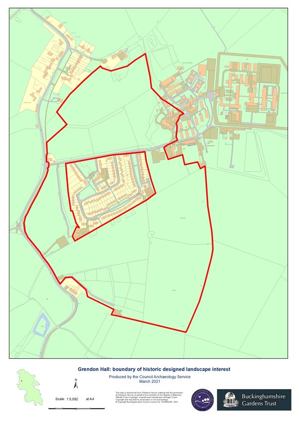
Bucks Gardens Trust, Site Dossier: Grendon Hall, Aylesbury Vale Area March 2021
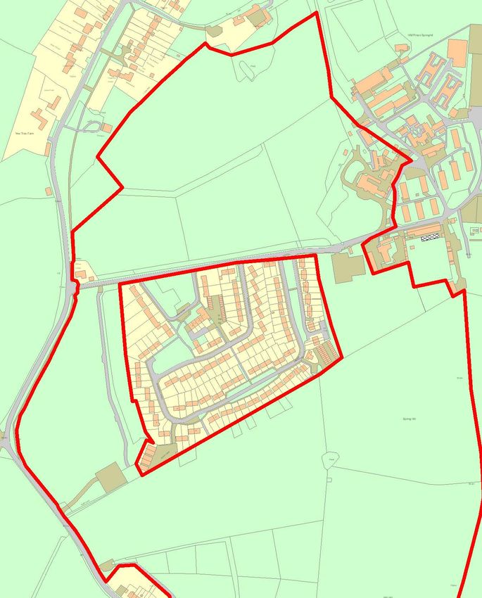
HISTORIC SITE BOUNDARY
2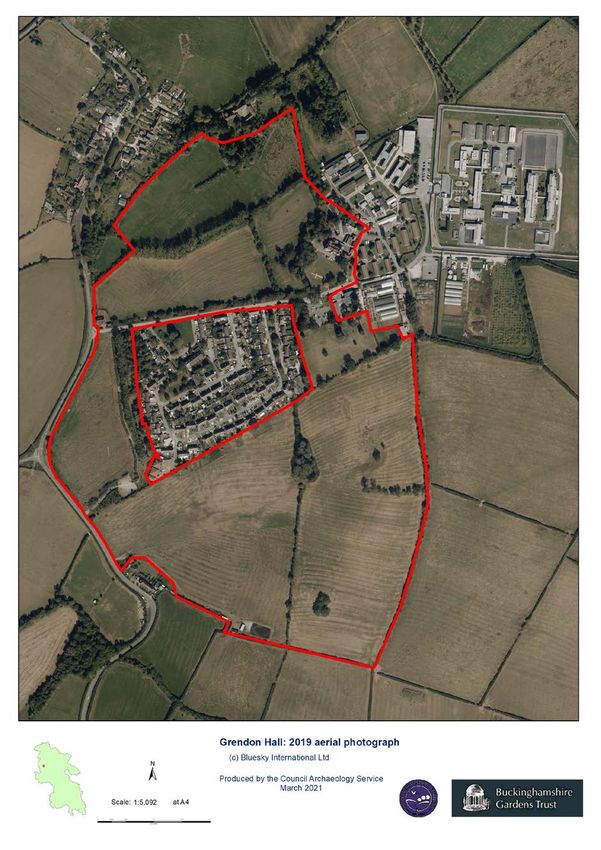
Bucks Gardens Trust, Site Dossier: Grendon Hall, Aylesbury Vale Area   March 2021

                                                            3
Bucks Gardens Trust, Site Dossier: Grendon Hall, Aylesbury Vale Area                         March 2021

INTRODUCTION

Background to the Project
This site dossier has been prepared as part of The Buckinghamshire Gardens Trust (BGT) Research
and Recording Project, begun in 2014. This site is one of several hundred designed landscapes
county‐wide identified by Bucks County Council in 1998 (including Milton Keynes District) as
potentially retaining evidence of historic interest, as part of the Historic Parks and Gardens Register
Review project carried out for English Heritage (now Historic England) (BCC Report No. 508). The list
is not definitive and further parks and gardens may be identified as research continues or further
information comes to light.

Content
BGT has taken the Register Review list as a sound basis from which to select sites for appraisal as
part of its Research and Recording Project for designed landscapes in the historic county of Bucks
(pre‐1974 boundaries). For each site a dossier is prepared by volunteers trained by BGT in appraising
designed landscapes.

Each dossier includes the following for the site:
       A site boundary mapped on the current Ordnance Survey to indicate the extent of the main
       part of the surviving designed landscape, also a current aerial photograph.
       A statement of historic significance based on the four Interests outlined in the National
       Planning Policy Framework and including an overview.
       A written description, derived from documentary research and a site visit, based on the
       format of Historic England Register of Parks & Gardens of special historic interest 2nd edn.
       A map showing principal views and features.

The area within the site boundary represents the significant coherent remains of the designed
landscape. It does not necessarily include all surviving elements of the historical landscape design,
which may be fragmented. It takes no account of current ownership.

NOTE: Sites are not open to the public unless advertised elsewhere.

Supporters and Acknowledgements
The project was funded by BGT, with significant grants from the Finnis Scott Foundation, the
Roland Callingham Foundation, BCC (since April 2020 part of Buckinghamshire Council) and
various private donors. Buckinghamshire Council also provided significant funding, and help in
kind including current and historic mapping and access to the Historic Environment Record. The
project is supported by The Gardens Trust.

The Trust thanks the volunteers and owners who have participated in this project and given so much
time and effort to complete this challenging and rewarding task.
Further information is available from: www.bucksgardenstrust.org.uk

                                                            4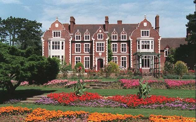
Bucks Gardens Trust, Site Dossier: Grendon Hall, Aylesbury Vale Area                         March 2021

SITE NAME: Grendon Hall                                            HER no: 1169100000

COUNTY: Bucks                                                      GRID REF: SP682 219
PARISH: Grendon Underwood                                          POSTCODE: HP18 0TL

STATEMENT OF SIGNIFICANCE

Overview

The pleasure ground and park for an 1880s country house on a new site, including terrace, informal
lawns with mature trees and shrubberies, and parkland, since the mid-C20 in institutional use as a
prison. The layout survives considerably intact, except for a 7ha. housing estate in the south park
and prison buildings in the pleasure grounds around the Hall to the east and south. A large prison
compound lies adjacent in the setting to the east.

Archaeological interest

Potential for evidence of Roman occupation is high, given the proximity to Akeman Street and
archaeological evidence nearby along the route of HS2. The medieval Forest of Bernwood provides
this area with a unique heritage, many of the features and place names being a direct legacy of the
ancient royal forest. Potential for evidence associated with the Forest particularly relates to banks,
routes, boundaries and buildings. The park is rich in ridge and furrow. Potential exists for former
features related to the designed landscape since the 1880s, such as buildings, paths, beds, terraces,
boundaries, and the lost north drive.

Architectural interest

This is a typical group of structures for a new country house of the 1880s. It is by an obscure but
competent amateur architect, Rev. Randolphe Henry Piggot, who, as well as the Hall, seemingly
designed the stable block, stable yard crenelated walls, lodge (gone), and associated structures. The
structures were typically united in the design using fashionable Jacobean style in red brick with
stone dressings. It is unclear whether Piggot designed buildings elsewhere. Unusually no kitchen
garden was provided.

Artistic interest

The layout comprises a largely typical ensemble of pleasure ground and park for a country house
developed in the 1880s with buildings in Jacobean style. The 1880s design incorporated hedgerow
trees as specimens in the new park and a straight main drive was framed by an avenue. Some of the
early specimens survive enclosing the informal lawns within the modest pleasure ground. Elements
lost to development include the 7ha. housing estate in the south park and prison buildings east and
south of the Hall. The rural setting enjoys views over the Vale of Aylesbury but has been damaged by
the large prison development immediately the east of the Hall.

Historic interest

The early history of the site has strong associations with the Forest of Bernwood.

                                                            5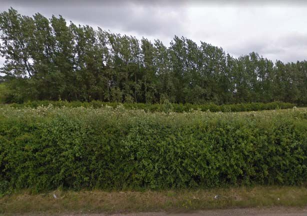
Bucks Gardens Trust, Site Dossier: Grendon Hall, Aylesbury Vale Area                         March 2021

HISTORIC DEVELOPMENT

Evidence for Roman occupation includes the remains of a late Roman settlement at Lawn Farm
north of the historic park boundary (BC monument record). The site lies north of the nearby Roman
Akeman Street, now the A41 road from Aylesbury to Bicester.

Grendon Underwood (Grendon under Bernwode) was recorded in Domesday and was part of
Bernwood Forest from before that time, being used as a hunting forest from the reign of Edward the
Confessor (1042-1066) whose royal palace was at Brill to the south. Grendon means a ‘green hill’
and Underwood refers to Bernwood. The area was only partially wooded, as medieval forests
included agricultural land and open land, and villages. During the reign of King John (1199-1216) the
Forest shrank in size and was disafforested. Remnants of Bernwood survive at Doddershall and
Grendon Woods (both SSSIs Bucks History Portal).

In 1068 Henry de Ferrers held the manor which eventually passed to the Braybroke family in 1402. In
1520 it was acquired by Thomas Piggot of Whaddon, who died that year, while his widow died in in
1549. The manor and that of Doddershall 3km to the west passed to their son Thomas and
descended through the family until the mid-C19 (VCH). C16 records mention a fishpond; however,
this is not shown on later maps (Bucks History Portal). The hunting status of the Forest was removed
in 1635. By 1812 (OS draft) the land was enclosed agricultural fields and a building, possibly a farm,
stood at the core of the present site. Further details about the Piggot family can be found in the
report on Doddershall (BGT 2017).

The Jervoise family of Herriard in Hampshire purchased a large part of the estate in 1796 and in the
mid-C19 William Piggot sold them the remainder of the Manor of Grendon Underwood. However, by
1873 it was back in the ownership of the Piggot family (VCH/Nat Arch).

Sir Thomas Digby Piggot was born in Buckinghamshire in 1840, the family’s main residence being
Doddershall. His mother Emma was an Upcher, a Norfolk family, and the Piggots had connections
with Norfolk and Cannock, Staffs. Piggot served as private secretary to Lord Northbrook, Lord
Lansdowne, and Lord Cranbrook. In 1888 he was appointed Controller of HM Stationery Office by
Disraeli. He was a keen amateur ornithologist and a writer, including of natural history stories for
children. His work brought him into contact with some of the foremost scientific men of the day,
including Walter Rothschild at nearby Tring. He was instrumental in the passing of the Wild Birds
Protection Act of 1880 (Obituary).

Following the reacquisition of the land at Grendon, Sir Digby financed the building of a new country
house on the estate and his brother, Rev. Randolphe Henry Piggot (rector and squire of Grendon
Underwood) was given the task of designing Grendon Hall. The gabled, Jacobethan, red brick house
is dated 1882 on a beam in the chapel. The grounds were laid out alongside the new house at this
time and in any case by the late 1890s (VCH; 1898 OS). Sir Digby never lived in the house, and as the
Old Grendon Rectory (1756) was not large enough to accommodate the Reverend’s large family and
servants they moved into the hall which was used as a rectory by Rev. Piggot until his death in 1900,
when Mrs Adeline Piggot became the lady of the manor; she died in 1932 (Houghton/VCH).

In 1911 Sir Digby retired and settled in Sheringham, Norfolk he died in 1927. The house was sold and
by 1913 Mr and Mrs A.E. Skinner were living there and they continued to maintain the garden.
During World War II the site was requisitioned, initially it was used by MI5 and from January 1942 as

                                                            6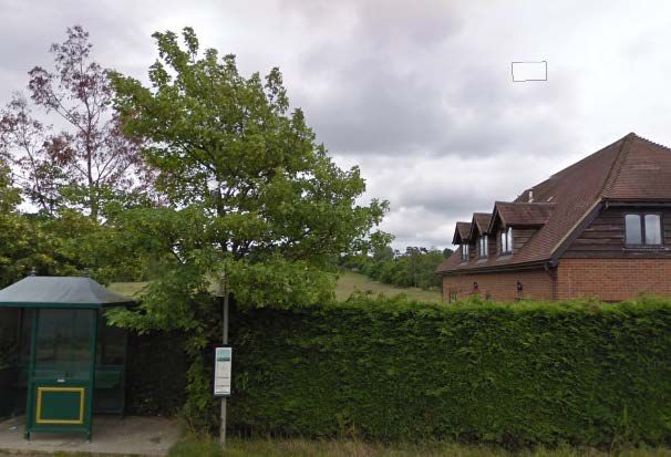
Bucks Gardens Trust, Site Dossier: Grendon Hall, Aylesbury Vale Area                          March 2021

Station 53 of SOE (Special Operations Executive) here new radio communications were developed in
conjunction with the new radio station at nearby Pounden House (BGT 2015). Towards the end of
the war the estate was also used as a fire training centre and then as a school for the daughters of
displaced Polish people until 1951. To accommodate more than 300 staff the pleasure grounds to
the north of the house were used for accommodation huts, recreation facilities and stores with
about ten more in the field beyond, this now forming part of the area occupied by the prison
(Houghton).

The site was purchased in 1953 by the Prisons Commission and HMP Springhill (Category D) became
the UK’s first open prison. In 1962 HMP Grendon (Category B) opened on the adjacent site, the UK’s
first prison to use psychotherapeutic treatment. Many skills were taught to the prisoners, gardening
being one (Wiki). A large kitchen garden was created to the south of the house which included
extensive polytunnels and vegetable beds. It was at its most productive from the mid-1960s through
to 2005, by which time its use was in decline (APs 1976, 1988, 2006).

In the 1960s Grendon housing estate was built in the area to the south of the approach road
(outside the historic site boundary) to house prison staff. The properties, which include small
businesses are in separate ownership having been sold in the late C20. The estate is still in public
ownership and used for prison purposes. Grendon Hall is used as offices.

SITE DESCRIPTION
LOCATION AREA BOUNDARIES LANDFORM AND SETTING

The village of Grendon Underwood sits in the Vale of Aylesbury between the neighbouring hamlets
of Woodham and Edgcott, 1km north of the A41, formerly the Roman road Akeman Street which
linked London to Cirencester. Aylesbury is 12km to the east and Bicester 10km to the west. The
37ha. site is situated 1km north of the village centre and 0.25km south of Edgcott.

The area is predominantly agricultural land interspersed with small areas of woodland; remnants of
Bernwood Forest are to be found at Grendon and Doddershall Woods (jointly an SSSI). The soil is
clay. The land is gently undulating and rises to 96m AOD at the core of the site. A tributary of the
River Ray (a tributary of the River Cherwell) rises in the park and flows south-west, hence Springhill.

In the C20 areas around the Hall were built over, with the development of the prisons, much of
which sits outside the historic boundary, and an area of the south park was lost to the Grendon
housing estate (outside the historic site boundary). Grendon Prison to the east was noted in 1994 as
having bleak buildings of 1962 by the Ministry of Works (Pevsner). Views remain from the house
north-east towards Edgcott and from the pleasure grounds and park south-west towards Mill Hill,
Doddershall Wood, and south to the village of Grendon Underwood and Waddesdon Hill in the
distance.

Starting from Hall Cottages (which were built to house servants in late C19) 750m south-west of the
house, the west boundary follows Edgcott Road and Grendon Road then turns north-west 50m after
the main entrance. The north boundary then follows the field line parallel to Edgcott, skirting Lawn
House (formerly The Rookery, Grade II) to the north. It then turns south as the east boundary,
through the centre of the prisons. It continues for 500m south along the line of a public bridleway
downhill and then turns back west along a footpath as the south boundary, re-joining the Edgcott
road after 250m. The boundaries are predominantly marked by hedges.

                                                            7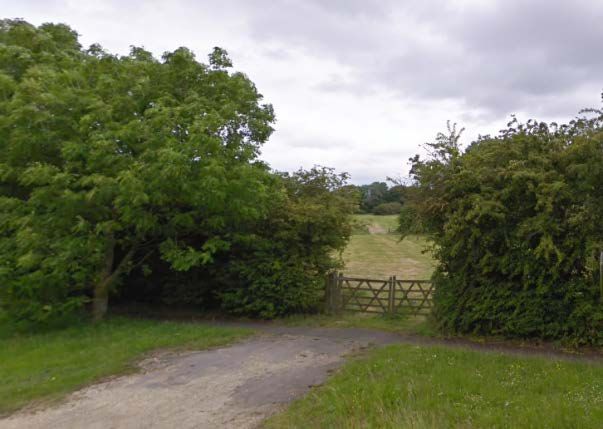
Bucks Gardens Trust, Site Dossier: Grendon Hall, Aylesbury Vale Area                           March 2021

ENTRANCES AND APPROACHES

The main entrance lies 450m west of the Hall and was created when the house was built in 1882.
The gateway (listed Grade II) stands on the east side of Edgcott Road. It is marked by two masonry
piers flanked by iron pedestrian gates and curved railings; the carriage gates are missing. The piers
are of red brick with stone bases, moulded cornices and obelisk finials. Pedestrian gates and railings
are wrought iron, the gates having standard panels with wavy Ionic pilasters and scrolled
overthrows, the railings with scrolled standards. The former carriage gates were probably of this
pattern too. North of the entrance Willow Lodge, c.1990s (AP 1999), replaces a lodge present by the
1890s which was presumably part of the creation of the drive when the house was built c.1882, by
the 1980s the Victorian lodge was in a state of disrepair and was demolished (Houghton; OS).

The straight asphalt drive runs 450m east from the gate, through the park to the pleasure grounds.
There are five turnings to the housing estate to the right: two for Park Road, two for Springhill Road
and one to Mill Corner (all outside the historic site boundary). Upon entering the pleasure grounds
the drive turns north for 75m to arrive at the south-west, entrance front of the house; the road
continues beyond this to the east into the prison complex. The area to the south and west of the
house is now parking.

In 1882 the drive followed a circuit and entered the pleasure grounds where it turned north, arriving
at the south-west, entrance front of the Hall after 60m. The former stable yard adjoining the house
to the east was reached via a spur from the drive through an arch in its east side, the spur is now
gone although part of the yard may survive (1898 OS; Historic image).

A service drive formerly gave access through the north of the park, entering via Lawn House Lane in
Edgcott, west of Lawn House. It ran south-east through the park to arrive at the north-east, service
front of the Hall (OS). This too had access to the stable yard, into the west side. A spur linked the
forecourt and service drive alongside the north-west side of the Hall.

PRINCIPAL BUILDING

Grendon Hall (listed Grade II) is situated near the east boundary of the roughly oval site. It is used as
offices for the prison. The E-shaped Hall is built in Jacobethan style. The north-west and south-west,
entrance, fronts overlook the pleasure grounds, with service fronts on the other two sides.

It is described as follows (Listing description):

‘Red brick with painted stone quoins, bonded window surrounds and copings, and moulded brick
eaves. Tiled roofs, brick chimneys. Jacobethan E-plan building with shallow projecting outer bays and
porch. Outer bays have shaped gables and 2-storey canted bay windows with painted stone mullions
and transoms, embattled ornament to parapets, and diaper panels between storeys. 3-light attic
windows with hoodmoulds and shields above. Intermediate bays each have 2 cross windows to each
storey and 2-light attic dormers with stone crosses in ogee gables, Central porch has 3-light
transomed window with hoodmould to first floor, 2-light attic window, and door in 4-centred stone
arch with hoodmould. Stone shields above door and in shaped gable of porch’. Chapel to rear of left
wing has battlemented porch with 2-centred arch. Altered chapel has open truss roof, inserted floor,
and coffin hatch with re-used C16 wooden surround’.

                                                            8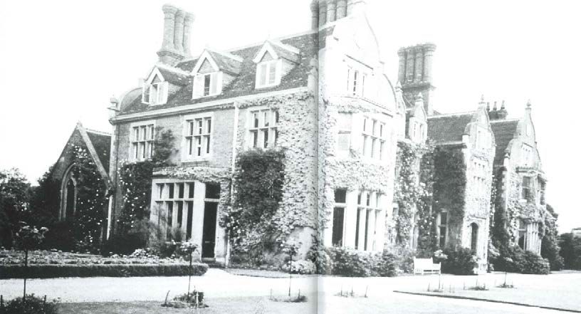
Bucks Gardens Trust, Site Dossier: Grendon Hall, Aylesbury Vale Area                        March 2021

THE GARDENS AND PLEASURE GROUNDS

The 1.5 hectare pleasure grounds formerly enclosed the Hall on all sides but have partly been
covered by C20 prison buildings to the east and north. They were laid out with informal trees, lawns
and shrubbery and included a small lake to the east of the house which was filled in when the prison
was built. The largest, south section remains and retains lawns through which the drive and formerly
paths thread. The west section is a car park enclosed by trees. Many of the C19 trees survive,
particularly around the perimeter.

The pleasure grounds were created when the house was built in the 1880s when mixed trees, both
deciduous and conifers, and shrubs were planted, and walks were laid out overlooking lawns to the
south. A photograph of 1910 shows the pleasure grounds beyond the lake to the east of the house,
this is the only image of the tower and shows a tunnel arbour in front of the crenelated walls of the
stable yard (Houghton). An early C20 photograph show a rockery. A photograph of an ‘Olde country
Faire’ on the lawns in front of the house in 1913 shows that the front of the house was covered with
climbers including roses (Bucks historic photos). A photograph from 1935 of the west façade
includes a parterre with beds enclosed by box hedging and standard rose bushes (Houghton). A
group of stone pine west of the house survived in the late C20, with other mature planting around it.
An undated photograph (probably early C20) of the sweeping drive to the front of the house shows
island beds in the lawn planted with roses and further shrubs planted on the east side of the drive.
The crenelated wall that extended from the east wing of the Hall screened the stable yard from
visitors, with the arched gateway giving pedestrian access to the rear of the house and gardens, and
a large archway in the wall as the stable yard entrance with its adjoining rustic tower were
demolished during WWII (Sketch of tower/Historic England image).

By c.2005, the south lawns below the entrance front of the house were planted by the prisoners
with rows of flower borders accessed via stone steps, and a gazebo was erected over the steps from
the terrace to the east of the house (see cover image). Their training included traditional bedding-
out of borders, one of the few places where this skill, popular in Victorian gardens and a feature in
public parks in the C20, was still taught. This is no longer the case and the beds are gone.

THE PARK

The park extends west and south of the house and is laid largely to pasture with a few mature
specimen trees. Initially an avenue of trees was planted along the drive (OS 1898) and other rows
broke up the landscape, probably remnants of field boundaries. These have largely been replaced by
hedging, dividing fields grazed by sheep, possibly during the time the site was requisitioned (APs
1947, 1976). One of the last remaining trees was a horse chestnut south of the car park, still standing
in 2005 but now probably gone. In the south park a belt of trees planted on the west boundary of
the 7ha. housing estate screens it from the road to the west.

Many views across the park from the drive, house and pleasure grounds survive.

KITCHEN GARDEN

It seems that no kitchen garden was laid out initially in the late C19 when the grounds were
designed. This is very unusual for an estate of this type and period.

                                                            9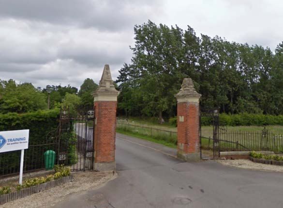
Bucks Gardens Trust, Site Dossier: Grendon Hall, Aylesbury Vale Area                         March 2021

With the arrival of the prisons after World War II, gardening become an important part of prisoners’
rehabilitation and two areas of productive kitchen garden were created within the prison site. These
included glasshouses in which flowers for cutting, bedding plants and pot plants would have been
grown. Enough fruit and vegetables were produced for the prison needs and the excess was sold to
the public. A historic image inside the glasshouse shows a prisoner being trained in the cultivation of
chrysanthemums. Since the beginning of the C21 this activity has been in decline and a relatively
small area is now cultivated (APs 1979, 1988, 2006).

REFERENCES

Bucks Gardens Trust (2017) ‘Doddershall Park’
https://bucksgardenstrust.org.uk/wp-content/uploads/2016/10/Doddershall_Park.pdf

Bucks Gardens Trust (2015) ‘Pounden House’

https://bucksgardenstrust.org.uk/wp-content/uploads/2015/03/Poundon_House.pdf

Houghton B, Images of Grendon Underwood and Kingswood (2000).
Victoria County History https://www.british-history.ac.uk/vch/bucks/vol4/pp50-54 (accessed
26/01/21)

Norfolk Naturalists 1927, Obituary of Sir Digby Piggot p.377
http://norfolknaturalists.org.uk/wp/wp-content/uploads/2017/02/Transactions-1926-27-
transactionsofno12norf_page_365-526.pdf (accessed online 27/01/21)

Pevsner, N. The Buildings of England - Buckinghamshire (1979), 148.

Watkin, B. A Shell Guide – Buckinghamshire (1981), 92.

https://www.wikitree.com/wiki/Pigott-300 (accessed 11/02/21)

https://en.wikipedia.org/wiki/HM_Prison_Grendon (accessed 12/02/21)

https://en.wikipedia.org/wiki/HM_Prison_Spring_Hill (accessed 12/02/21)

https://discovery.nationalarchives.gov.uk/details/r/c301bb65-1cdd-4b87-82ba-9e66be336270
(accessed 12/02/21)

https://heritageportal.buckinghamshire.gov.uk/Theme/TBC747 (accessed 12/02/12)

https://heritageportal.buckinghamshire.gov.uk/Monument/MBC25038 (accessed 15/02/21)

Ordnance Survey
1812 OS surveyor’s draft, 2″ to 1 mile
1880 1st edition, 25″ to 1 mile
1885 1st edition 6″ to 1 mile
1898 6″ to 1 mile
1898 25″ to 1 mile
1900 2nd edition 6″ to 1 mile
1950 6″ to 1 mile
1984 National grid 1:10,000

                                                           10
Bucks Gardens Trust, Site Dossier: Grendon Hall, Aylesbury Vale Area March 2021
Images
Aerial photographs 1947 (RAF), 1976 (British Gas), 1985, 1988, 1999, 2003, 2006, 2019
https://www.geograph.org.uk/photo/436628/417956/489352/434710/417947 (accessed 11/2/21)
https://www.buckscc.gov.uk/services/culture-and-leisure/buckinghamshire-archives/online-
resources/historic-photographs/ (accessed 12/02/21)
Ref: phgrendonunderwood18, phgrendonunderwood19.
https://www.ebay.ie/itm/1953-London-Prisoner-Lawn-Grendon-Hall-Minimum-Security-Castle-
Estate-News/164691579434?hash=item265862122a:g:oNwAAOSwhcZePYyM
Historic England images (accessed online 12/02/21) Ref: bb98/01998 (1904), 0311_171, 0311_173
Google Earth (accessed 12/02/20)
https://www.thesun.co.uk/news/4965398/hmp-springhill-three-escaped-prisoners-killer/ (cover
image)
C de C March 2021, edited SR March 2021
11Bucks Gardens Trust, Site Dossier: Grendon Hall, Aylesbury Vale Area March 2021
KEY HISTORIC FEATURES & VIEWS
5
5
5
5
2
7
1
6
4
4
3
8
Key to numbered features
1. House 2. Stable block and yard, entrances to west and east
3. West entrance & Willow Lodge 4. West drive
5. North drive (site) 6. Pleasure Grounds
7. North park 8. South park
12Bucks Gardens Trust, Site Dossier: Grendon Hall, Aylesbury Vale Area March 2021
RECENT IMAGES
Gate piers at main entrance View back to park from Edgcott Road
View north across park to Spring Hill Willow Lodge with park beyond
Tree belt screening housing estate in park Bridleway to Doddershall Woods (2005)
View south from park towards Waddesdon Hill (2005) Spring Hill with Mill Hill beyond (2005)
13Bucks Gardens Trust, Site Dossier: Grendon Hall, Aylesbury Vale Area March 2021
View south from carpark (2005) Garden front (2005)
HISTORIC IMAGES
Garden front (circa 1913) chapel to the rear to left and gateway to stable yard to right.
The stable yard 1904 (Historic England)
14Bucks Gardens Trust, Site Dossier: Grendon Hall, Aylesbury Vale Area March 2021
Entrance gates and former lodge (demolished 1980s) photograph 1910
Lodge and gates 1915
Sketch of tower and entrance circa 1910
15Bucks Gardens Trust, Site Dossier: Grendon Hall, Aylesbury Vale Area March 2021
View of east side of house, across the lake, showing tower at entrance to the service yard
(demolished during WWII) and tunnel arbour to the right C. 1910
View of west façade of house showing pleasure grounds and chapel to the rear 1935
16Bucks Gardens Trust, Site Dossier: Grendon Hall, Aylesbury Vale Area March 2021
Rows of trees in park (now gone) Rockery in pleasure ground (now gone)
There may be more details on the planting in the 1912 sales particulars (Bucks County Archive)
Carriage drive, with island beds and stable entrance to right of Hall HMP inside the glasshouses
Prisoners gardening 1953
17You can also read